List of Washington Natural Area Preserves

Last updated
Map all coordinates using: OpenStreetMap  
Download coordinates as: KML  ·  GPX

This is a list of Natural Area Preserves (NAPs), part of the Washington Natural Areas Program managed by Washington Department of Natural Resources.

NameCountyLocation/GPS CoordinatesNotes
Marcellus Shrub SteppeAdams 47°13′52″N118°24′43″W / 47.231°N 118.412°W / 47.231; -118.412 (Marcellus Shrub Steppe)
Camas MeadowsChelan 47°29′20″N120°35′42″W / 47.489°N 120.595°W / 47.489; -120.595 (Camas Meadows)
Entiat SlopesChelan 47°38′56″N120°15′04″W / 47.649°N 120.251°W / 47.649; -120.251 (Entiat Slopes)
Upper Dry GulchChelan 47°19′52″N120°08′56″W / 47.331°N 120.149°W / 47.331; -120.149 (Upper Dry Gulch)
Washougal OaksClark 45°33′54″N122°16′12″W / 45.565°N 122.270°W / 45.565; -122.270 (Washougal Oaks) Largest remaining Garry oak forest in Western Washington [1]
The Two-SteppeDouglas 47°35′56″N119°37′59″W / 47.599°N 119.633°W / 47.599; -119.633 (The Two-Steppe)
Kahlotus RidgetopFranklin 46°41′42″N118°33′18″W / 46.695°N 118.555°W / 46.695; -118.555 (Kahlotus Ridgetop)
Castle RockGrant 47°53′24″N119°03′54″W / 47.890°N 119.065°W / 47.890; -119.065 (Castle Rock)
Carlisle BogGrays Harbor 47°08′35″N124°05′02″W / 47.143°N 124.084°W / 47.143; -124.084 (Carlisle Bog NAP) Sphagnum bog
Chehalis River Surge PlainGrays Harbor 46°56′28″N123°42′18″W / 46.941°N 123.705°W / 46.941; -123.705 (Chehalis River Surge Plain NAP)
Goose IslandGrays Harbor 46°58′44″N124°04′12″W / 46.979°N 124.070°W / 46.979; -124.070 (Goose Island) Island in Grays Harbor, sometimes submerged
North BayGrays Harbor 47°02′56″N124°06′11″W / 47.049°N 124.103°W / 47.049; -124.103 (North Bay NAP) Sphagnum bog
Sand Island Grays Harbor 46°57′43″N124°03′43″W / 46.962°N 124.062°W / 46.962; -124.062 (Sand Island) Island in Grays Harbor, sometimes submerged
Whitcomb FlatsGrays Harbor 46°54′32″N124°04′26″W / 46.909°N 124.074°W / 46.909; -124.074 (Whitcomb Flats) Island in Grays Harbor, sometimes submerged
Admiralty InletIsland 48°10′34″N122°41′10″W / 48.176°N 122.686°W / 48.176; -122.686 (Admiralty Inlet NAP) Located inside Ebey's Landing National Historical Reserve; population of threatened golden paintbrush [2]
Clearwater BogsJefferson 47°34′59″N124°09′54″W / 47.583°N 124.165°W / 47.583; -124.165 (Clearwater Bogs) Sphagnum bog
Dabob BayJefferson 47°50′02″N122°49′37″W / 47.834°N 122.827°W / 47.834; -122.827 (Dabob Bay NAP)
Charley CreekKing 47°14′31″N121°47′35″W / 47.242°N 121.793°W / 47.242; -121.793 (Charley Creek)
Kings Lake BogKing 47°35′46″N121°46′44″W / 47.596°N 121.779°W / 47.596; -121.779 (Kings Lake Bog NAP) Sphagnum bog
Snoqualmie BogKing 47°39′43″N121°37′19″W / 47.662°N 121.622°W / 47.662; -121.622 (Snoqualmie Bog NAP) Sphagnum bog
Kitsap ForestKitsap 47°36′43″N122°52′01″W / 47.612°N 122.867°W / 47.612; -122.867 (Kitsap Forest) One of the last old-growth forests in Puget Sound region [3]
Badger GulchKlickitat 45°50′31″N120°32′13″W / 45.842°N 120.537°W / 45.842; -120.537 (Badger Gulch) Oak savanna
Cleveland Shrub SteppeKlickitat 45°57′40″N120°22′34″W / 45.961°N 120.376°W / 45.961; -120.376 (Cleveland Shrub Steppe)
Columbia Hills Klickitat 45°42′14″N121°04′30″W / 45.704°N 121.075°W / 45.704; -121.075 (Columbia Hills NAP)
Monte CristoKlickitat 45°54′22″N121°33′25″W / 45.906°N 121.557°W / 45.906; -121.557 (Monte Cristo)
Trout LakeKlickitat 46°01′05″N121°33′47″W / 46.018°N 121.563°W / 46.018; -121.563 (Trout Lake NAP)
Spring Creek CanyonLincoln 47°45′00″N117°53′20″W / 47.750°N 117.889°W / 47.750; -117.889 (Spring Creek Canyon NAP)
Hamma Hamma Balds Mason 47°35′06″N123°04′30″W / 47.585°N 123.075°W / 47.585; -123.075 (Hamma Hamma Balds NAP) Rocky balds
Ink Blot Mason 47°17′35″N123°14′31″W / 47.293°N 123.242°W / 47.293; -123.242 (Ink Blot NAP) Sphagnum bog
Oak PatchMason 47°28′37″N122°55′12″W / 47.477°N 122.920°W / 47.477; -122.920 (Oak Patch NAP)
Schumacher CreekMason 47°18′40″N123°04′48″W / 47.311°N 123.080°W / 47.311; -123.080 (Hamma Hamma Balds NAP) Also spelled Schumocher Creek
Critically imperiled Sitka alder/skunk cabbage/water parsley community [4]
Skookum InletMason 47°08′20″N123°04′52″W / 47.139°N 123.081°W / 47.139; -123.081 (Skookum Inlet NAP)
Kennedy Creek Mason and Thurston 47°05′42″N123°04′48″W / 47.095°N 123.080°W / 47.095; -123.080 (Kennedy Creek NAP) One of the largest Chum salmon spawning areas in the lower Puget Sound [5]
Barker MountainOkanogan 48°40′48″N119°18′00″W / 48.680°N 119.300°W / 48.680; -119.300 (Barker Mountain NAP)
Chopaka Mountain Okanogan 48°58′30″N119°46′48″W / 48.975°N 119.780°W / 48.975; -119.780 (Chopaka Mountain NAP) 2,764 acres (1,119 ha) surrounding summit of Chopaka Mountain [6]
Davis CanyonOkanogan 48°14′24″N119°45′58″W / 48.240°N 119.766°W / 48.240; -119.766 (Davis Canyon NAP)
Methow RapidsOkanogan 48°01′55″N119°53′31″W / 48.032°N 119.892°W / 48.032; -119.892 (Methow Rapids NAP)
Riverside BreaksOkanogan 48°29′02″N119°29′46″W / 48.484°N 119.496°W / 48.484; -119.496 (Riverside Breaks NAP)
Bone River Pacific 46°39′32″N123°52′12″W / 46.659°N 123.870°W / 46.659; -123.870 (Bone River NAP)
Gunpowder IslandPacific 46°39′29″N124°02′10″W / 46.658°N 124.036°W / 46.658; -124.036 (Gunpowder Island NAP)
Niawiakum RiverPacific 46°37′55″N123°54′50″W / 46.632°N 123.914°W / 46.632; -123.914 (Niawiakum River NAP)
Willapa DividePacific 46°26′53″N123°34′52″W / 46.448°N 123.581°W / 46.448; -123.581 (Willapa Divide NAP) Old-growth forest [7]
Point DoughtySan Juan 48°42′29″N122°56′28″W / 48.708°N 122.941°W / 48.708; -122.941 (Point Doughty NAP) Adjacent to Point Doughty Recreation Site [8] [9]
Cypress HighlandsSkagit 48°34′44″N122°43′30″W / 48.579°N 122.725°W / 48.579; -122.725 (Cypress Highlands NAP) Wetlands and rocky balds
Olivine BridgeSkagit 48°36′54″N121°54′18″W / 48.615°N 121.905°W / 48.615; -121.905 (Olivine Bridge NAP) Dwarf forest on serpentine soil [10]
Skagit Bald EagleSkagit 48°28′08″N121°27′11″W / 48.469°N 121.453°W / 48.469; -121.453 (Skagit Bald Eagle NAP) 1,546 acres (626 ha), part of 8,000-acre (3,200 ha) Skagit River Bald Eagle Natural Area [11]
Columbia FallsSkamania 45°36′54″N122°08′02″W / 45.615°N 122.134°W / 45.615; -122.134 (Columbia Falls NAP) Threatened Larch Mountain salamander, threatened and sensitive plant species [12]
PinecroftSpokane 47°40′55″N117°13′55″W / 47.682°N 117.232°W / 47.682; -117.232 (Pinecroft NAP)
Little Pend Oreille RiverStevens 48°35′20″N117°33′18″W / 48.589°N 117.555°W / 48.589; -117.555 (Little Pend Oreille River NAP)
Bald HillThurston 46°49′16″N122°25′59″W / 46.821°N 122.433°W / 46.821; -122.433 (Bald Hill NAP) Cliffs and rocky balds; over 1,000 plant species [13]
Mima Mounds Thurston 46°53′N123°03′W / 46.89°N 123.05°W / 46.89; -123.05 (Mima Mounds NAP)
Rocky PrairieThurston 46°55′05″N122°51′32″W / 46.918°N 122.859°W / 46.918; -122.859 (Rocky Prairie NAP)
Dailey PrairieWhatcom 48°43′23″N122°02′13″W / 48.723°N 122.037°W / 48.723; -122.037 (Dailey Prairie NAP)
Selah CliffsYakima 46°42′18″N120°27′18″W / 46.705°N 120.455°W / 46.705; -120.455 (Selah Cliffs NAP) Near Selah Creek Bridge; largest known population of threatened basalt daisy [14]

Notes

  1. Washougal Oaks NAP, Washington DNR, archived from the original on 2013-04-14, retrieved 2013-05-24
  2. Admiralty Inlet NAP, Washington DNR, archived from the original on 2014-04-13
  3. Kitsap Forest NAP, Washington DNR, archived from the original on 2013-04-13, retrieved 2013-05-24
  4. Schumacher Creek NAP, Washington DNR, archived from the original on 2013-04-14, retrieved 2013-05-24
  5. Christopher Smith; Laura Ritter, Engineering with Nature: Alternative Techniques to Riprap Bank Stabilization, Federal Emergency Management Agency
  6. Chopaka Mountain NAP, Washington DNR, archived from the original on 2011-05-20
  7. Willapa Divide NAP, Washington DNR, archived from the original on 2013-04-13, retrieved 2013-05-24
  8. "Site analysis: Point Doughty" (PDF), Trust Lands Guidelines, San Juan County, archived from the original (PDF) on 2016-03-03, retrieved 2013-05-24
  9. Washington sea kayaking: Point Doughty on Orcas Island, Recreational Equipment, Inc. (REI), retrieved 2013-05-24
  10. Olivine Bridge NAP, Washington DNR, archived from the original on 2013-04-13, retrieved 2013-05-24
  11. Skagit Wild and Scenic River System—Wildlife, United States Forest Service, retrieved 2013-05-24
  12. Columbia Falls NAP, Washington DNR, archived from the original on 2013-04-14, retrieved 2013-05-24
  13. Ed Alvorson; Reid Schuller; Shelly Evans; Jim Barrett; Ed Alvorson (c. 1988), "Bald Hill Lake, Thurston County, Washington", WNPS Plant List, Washington Native Plant Society, retrieved 2013-05-24
  14. Selah Cliffs NAP, Washington DNR, archived from the original on 2013-04-14, retrieved 2013-05-24

Sources

Related Research Articles

Natural Resources Conservation Service (NRCS), formerly known as the Soil Conservation Service (SCS), is an agency of the United States Department of Agriculture (USDA) that provides technical assistance to farmers and other private landowners and managers.

The Indiana Department of Natural Resources (DNR) is the agency of the U.S. state of Indiana. There are many divisions within the DNR and each has a specific role. The DNR is not only responsible for maintaining resource areas but also manages Indiana's fish and wildlife, reclaims coal mine ground, manages forested areas, aids in the management of wildlife on private lands, enforces Indiana's conservation laws, and many other duties not named here. According to the department's website, their mission is "to protect, enhance, preserve, and wisely use natural, cultural, and recreational resources for the benefit of Indiana's citizens through professional leadership, management, and education".

Mattawoman Creek coastal plain tributary in Maryland, United States

Mattawoman Creek is a 30.0-mile-long (48.3 km) coastal-plain tributary to the tidal Potomac River with a mouth at Indian Head, Maryland, 20 miles (32 km) downstream of Washington, D.C. It comprises a 23-mile (37 km) river flowing through Prince George's and Charles counties and a 7-mile (11 km) tidal-freshwater estuary in Charles County. About three-fourths of its 94-square-mile (240 km2) watershed lies in Charles County, with the remainder in Prince George's County immediately to the north.

Minnesota Department of Natural Resources

The Minnesota Department of Natural Resources is the agency of the U.S. state of Minnesota charged with conserving and managing the state's natural resources. The agency maintains areas such as state parks, state forests, recreational trails, and recreation areas as well as managing minerals, wildlife, and forestry throughout the state. The agency is divided into six divisions - Ecological & Water Resources, Enforcement, Fish & Wildlife, Forestry, Lands & Minerals, and Parks & Trails.

Wisconsin Department of Natural Resources government agency

The Wisconsin Department of Natural Resources (WDNR) is an agency of the state of Wisconsin charged with conserving and managing Wisconsin's natural resources. The Wisconsin Natural Resources Board has the authority to set policy for the WDNR. The WDNR is led by the Secretary, who is appointed by the Governor of Wisconsin. The WDNR develops regulations and guidance in accordance with laws passed by the Wisconsin Legislature. It administers wildlife, fish, forests, endangered resources, air, water, waste, and other issues related to natural resources. The central office of the WDNR is located in downtown Madison, near the state capitol.

Michigan Department of Natural Resources

The Michigan Department of Natural Resources (DNR) is the agency of the state of Michigan charged with maintaining natural resources such as state parks, state forests, and recreation areas. It is governed by a director appointed by the Governor and accepted by the Natural Resources Commission. Currently the Director is Keith Creagh. The DNR has about 1,400 permanent employees, and over 1,600 seasonal employees.

The Iowa Department of Natural Resources is a department/agency of the U.S. state of Iowa formed in 1986, charged with maintaining state parks and forests, protecting the environment of Iowa, and managing energy, fish, wildlife, land resources, and water resources of Iowa.

The Maryland Department of Natural Resources (DNR) is a government agency in the state of Maryland charged with maintaining natural resources including state parks, public lands, state forests, state waterways, wildlife and recreation areas. Its headquarters are in Annapolis.

Dominion Energy company

Dominion Energy, Inc., commonly referred to as Dominion, is an American power and energy company headquartered in Richmond, Virginia that supplies electricity in parts of Virginia, North Carolina, and South Carolina and supplies natural gas to parts of Utah, West Virginia, Ohio, Pennsylvania, North Carolina, South Carolina, and Georgia. Dominion also has generation facilities in Indiana, Illinois, Connecticut, and Rhode Island.

The Maryland Natural Resources Police (NRP) is the law enforcement arm of the Maryland Department of Natural Resources (DNR). Natural Resources Police Officers patrol state-owned lands and enforce conservation and boating laws as well as Maryland's Criminal Law and Transportation Article. NRP is also the primary law enforcement agency on the waterways of Maryland and is the primary response agency for all homeland security threats on Maryland waterways.

Washington State Department of Natural Resources State agency managing state trust lands

The Washington State Department of Natural Resources (DNR) manages over 3,000,000 acres (12,000 km2) of forest, range, agricultural, and commercial lands in the U.S. state of Washington. The DNR also manages 2,600,000 acres (11,000 km2) of aquatic areas which include shorelines, tidelands, lands under Puget Sound and the coast, and navigable lakes and rivers. Part of the DNR's management responsibility includes monitoring of mining cleanup, environmental restoration, providing scientific information about earthquakes, landslides, and ecologically sensitive areas. DNR also works towards conservation, in the form of Aquatic Reserves such as Maury Island and in the form of Natural Area Preserves like Mima Mounds or Natural Resource Conservation Areas like Woodard Bay Natural Resource Conservation Area.

Greenleaf Lake State Recreation Area

Greenleaf Lake State Recreation Area is a state park unit of Minnesota, USA, currently in development. It includes undeveloped shoreline on both Greenleaf and Sioux Lakes, halfway between the cities of Hutchinson and Litchfield in Meeker County. Portions of the state recreation area (SRA) are open to the public for day-use recreation, but there are no facilities yet on site. The park boundaries were set by the Minnesota Legislature and the state is still acquiring land from willing sellers; two-thirds of the property remain privately owned.

Geoduck aquaculture

Geoduck aquaculture or geoduck farming is the practice of cultivating geoducks for human consumption. The geoduck is a large edible saltwater clam, a marine bivalve mollusk, that is native to the Pacific Northwest.

Kennedy Creek Natural Area Preserve

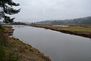
Kennedy Creek Natural Area Preserve is a state-protected Natural Area near US Highway 101 on Oyster Bay, Puget Sound, in southwest Washington state, United States. The preserve is on the border of Thurston County and Mason County and contains 203 acres (82 ha) of intertidal salt marsh and upland forest.

Ink Blot Natural Area Preserve

Ink Blot Natural Area Preserve is a Washington state Natural Area Preserve located in Mason County. The preserve totals 153 acres (62 ha), mostly wetlands and Sphagnum bogs in three parallel glacier-formed basins.

Hamma Hamma Balds Natural Area Preserve

Hamma Hamma Balds is a Washington state Natural Area Preserve. It is located in the eastern foothills of the Olympic Mountains in Mason County, above the Hamma Hamma River and adjacent to Olympic National Forest. The term "balds" refers to rocky outcroppings in the heavy forest. The preserve totals 957 acres (387 ha).

Admiralty Inlet Natural Area Preserve in Island County, Washington is part of the Washington Natural Areas Program. It lies along Admiralty Inlet within Ebey's Landing National Historical Reserve on land owned by the Whidbey Camano Land Trust with a conservation easement owned by the Washington Department of Natural Resources. Admiralty Inlet NAP is home to one of only 11 remaining populations of golden paintbrush, a flowering plant listed as threatened under the Endangered Species Act. The preserve's 46 acres (19 ha) includes old-growth forest, a rare remnant prairie, and shoreline.