List of dams in Akita Prefecture

Last updated

Map of dams in Akita Prefecture.(See Wikidata query)

The following is a list of dams in Akita Prefecture, Japan.

Contents

List

NameLocationOpenedHeightImage
Ainono Dam   OOjs UI icon edit-ltr-progressive.svg 39°16′48″N 140°38′42″E [1] 196140.8 m (134 ft)
Akazawa Dam   OOjs UI icon edit-ltr-progressive.svg 39°9′56″N 140°21′8″E 193519.3 m (63 ft)
Asahikawa Chisui Dam   OOjs UI icon edit-ltr-progressive.svg 39°48′7″N 140°13′0″E 197251.5 m (169 ft) Asahikawa Chisui Dam in autumn 2019.jpg
Bessho Tameike Dam   OOjs UI icon edit-ltr-progressive.svg 40°12′41″N 140°41′36″E 195719 m (62 ft)
Chokai Dam   OOjs UI icon edit-ltr-progressive.svg 39°7′30″N 140°9′20″E 199381 m (266 ft)
Etsuri Dam   OOjs UI icon edit-ltr-progressive.svg 40°15′14″N 140°35′4″E 194917.7 m (58 ft)
Fujikura Dam  OOjs UI icon edit-ltr-progressive.svg 39°47′22″N 140°11′56″E Fujikura Dam (Teng Cang damu) - panoramio.jpg
Haginari Dam   OOjs UI icon edit-ltr-progressive.svg 39°55′28″N 140°18′48″E [1] 196661 m (200 ft) Haginari Dam.jpg
Hanekawa Dam   OOjs UI icon edit-ltr-progressive.svg 40°3′33″N 140°6′29″E [1] 196717.7 m (58 ft)
Hayakuchi Dam   OOjs UI icon edit-ltr-progressive.svg 40°24′17″N 140°21′16″E [1] 197661 m (200 ft) Hayaguti Dam.jpg
Hokiden Tameike Dam   OOjs UI icon edit-ltr-progressive.svg 39°48′59″N 140°6′56″E 193825.7 m (84 ft)
Hotokezawa Dam   OOjs UI icon edit-ltr-progressive.svg 39°25′48″N 140°36′50″E 193524.7 m (81 ft)
Hotta Tameike Dam   OOjs UI icon edit-ltr-progressive.svg 39°48′48″N 140°7′6″E 195622.6 m (74 ft)
Ichijogi Dam   OOjs UI icon edit-ltr-progressive.svg 39°27′59″N 140°36′22″E 193818.5 m (61 ft)
Itado Dam   OOjs UI icon edit-ltr-progressive.svg 39°4′4″N 140°35′49″E [1] 198328.7 m (94 ft)
Iwagami Dam   OOjs UI icon edit-ltr-progressive.svg 40°16′39″N 140°35′40″E 196923.3 m (76 ft)
Iwami Dam   OOjs UI icon edit-ltr-progressive.svg 39°44′43″N 140°20′34″E [1] 197866.5 m (218 ft)
Jindai Dam   OOjs UI icon edit-ltr-progressive.svg 39°37′49″N 140°41′11″E [1] 194026.5 m (87 ft)
Kagura Dam   OOjs UI icon edit-ltr-progressive.svg 40°19′47″N 140°45′43″E 195720 m (66 ft) Kagura Dam.jpg
Kanazawa Dam   OOjs UI icon edit-ltr-progressive.svg 39°22′44″N 140°35′13″E [1] 198029.2 m (96 ft)
Karasawa No.1 Dam   OOjs UI icon edit-ltr-progressive.svg 40°15′45″N 140°35′19″E 195116 m (52 ft)
Katajiri Dam   OOjs UI icon edit-ltr-progressive.svg 39°24′12″N 140°36′58″E [1] 196331.8 m (104 ft)
Kohabiro Dam   OOjs UI icon edit-ltr-progressive.svg 39°23′14″N 140°14′11″E 197220 m (66 ft)
Kurakarizawa Dam   OOjs UI icon edit-ltr-progressive.svg 39°12′45″N 140°34′37″E 194518.6 m (61 ft)
Kuromorigawa No.1 Dam   OOjs UI icon edit-ltr-progressive.svg 39°17′48″N 140°2′31″E 197626 m (85 ft)
Kuzugasawa Dam   OOjs UI icon edit-ltr-progressive.svg 39°21′34″N 140°23′11″E 194318.8 m (62 ft)
Kyowa Dam   OOjs UI icon edit-ltr-progressive.svg 39°41′34″N 140°26′28″E [1] 199749.3 m (162 ft)
Magura Dam   OOjs UI icon edit-ltr-progressive.svg 39°14′50″N 140°34′28″E 193125.5 m (84 ft)
Matsukura Dam   OOjs UI icon edit-ltr-progressive.svg 39°10′5″N 140°19′52″E [1] 196121.9 m (72 ft)
Matsumine Tameike Dam   OOjs UI icon edit-ltr-progressive.svg 40°18′43″N 140°32′26″E 199219.9 m (65 ft)
Minase Dam   OOjs UI icon edit-ltr-progressive.svg 39°3′24″N 140°37′47″E [1] 196366.5 m (218 ft) MinaseDam1.JPG
Mizusawa Dam   OOjs UI icon edit-ltr-progressive.svg 40°21′32″N 140°5′45″E [1] 199446.5 m (153 ft) Mizusawa Dam.JPG
Moriyoshi Dam   OOjs UI icon edit-ltr-progressive.svg 40°2′52″N 140°36′23″E [1] 195262 m (203 ft) Moriyosi damu.jpg
Moriyoshizan Dam   OOjs UI icon edit-ltr-progressive.svg 40°2′9″N 140°27′28″E 201189.9 m (295 ft) Moriyoshizan-395-r1.JPG
Myoei Tameike Dam   OOjs UI icon edit-ltr-progressive.svg 39°19′42″N 140°34′16″E 193518.3 m (60 ft)
Naganuma Dam   OOjs UI icon edit-ltr-progressive.svg 39°21′59″N 140°36′55″E 195416.5 m (54 ft)
Nangai Dam   OOjs UI icon edit-ltr-progressive.svg 39°26′13″N 140°17′52″E [1] 197821.4 m (70 ft)
Naruse Dam   OOjs UI icon edit-ltr-progressive.svg 39°2′26″N 140°43′17″E 1983114.5 m (376 ft)
Natsuze Dam   OOjs UI icon edit-ltr-progressive.svg 39°38′4″N 140°42′38″E [1] 194040 m (130 ft)
Ohbuka Dam   OOjs UI icon edit-ltr-progressive.svg 39°55′42″N 140°47′56″E 196121.6 m (71 ft)
Ohdutsumi Dam   OOjs UI icon edit-ltr-progressive.svg 39°57′7″N 139°45′46″E 192115.6 m (51 ft)
Omatsukawa Dam   OOjs UI icon edit-ltr-progressive.svg 39°18′29″N 140°38′43″E [1] 199865 m (213 ft)
Ohtakisawa Tameike Dam   OOjs UI icon edit-ltr-progressive.svg 39°46′43″N 140°9′11″E 193726.6 m (87 ft)
Ohuchi Dam   OOjs UI icon edit-ltr-progressive.svg 39°26′12″N 140°15′20″E 200727.5 m (90 ft)
Ohyoshizawa Tameike Dam   OOjs UI icon edit-ltr-progressive.svg 39°58′6″N 140°9′1″E 193418.5 m (61 ft)
Rokkamura Dam   OOjs UI icon edit-ltr-progressive.svg 39°25′5″N 140°6′5″E 195217.6 m (58 ft)
Sarutasawa Tameike Dam   OOjs UI icon edit-ltr-progressive.svg 39°48′33″N 140°7′7″E 193820.5 m (67 ft)
Shaka-ike Dam   OOjs UI icon edit-ltr-progressive.svg 40°19′45″N 140°36′11″E 194321.4 m (70 ft)
Shinzan No.1 Dam   OOjs UI icon edit-ltr-progressive.svg 39°55′49″N 139°46′23″E 192217.4 m (57 ft)
Sodegasawa Tsutsumi Dam   OOjs UI icon edit-ltr-progressive.svg 39°55′28″N 140°9′42″E 193417.1 m (56 ft)
Sotonosawa Dam   OOjs UI icon edit-ltr-progressive.svg 40°3′44″N 140°7′51″E 195215 m (49 ft)
Subari Dam   OOjs UI icon edit-ltr-progressive.svg 40°20′1″N 140°13′22″E [1] 197072 m (236 ft) SubariDam.jpg
Suganosawa Dam   OOjs UI icon edit-ltr-progressive.svg 40°8′8″N 140°7′10″E 191216 m (52 ft)
Suginosawa Dam   OOjs UI icon edit-ltr-progressive.svg 39°23′41″N 140°25′36″E 193415.5 m (51 ft)
Sunakozawa Dam   OOjs UI icon edit-ltr-progressive.svg 40°22′34″N 140°46′7″E 201078.5 m (258 ft) Sunakozawa Dam.jpg
Takikawa Dam   OOjs UI icon edit-ltr-progressive.svg 39°54′45″N 139°47′43″E [1] 199828.7 m (94 ft)
Takinosawa Tameike Dam   OOjs UI icon edit-ltr-progressive.svg 39°44′56″N 140°10′36″E 193420.3 m (67 ft)
Tamagawa Dam  OOjs UI icon edit-ltr-progressive.svg 39°49′51″N 140°38′25″E Tamagawa Dam.jpg
Tengusawanuma Dam   OOjs UI icon edit-ltr-progressive.svg 39°20′54″N 140°34′54″E 193218 m (59 ft)
Yamase Dam  OOjs UI icon edit-ltr-progressive.svg 40°22′12″N 140°28′19″E [1] Yamase Dam1.jpg
Yashio Dam   OOjs UI icon edit-ltr-progressive.svg 39°15′36″N 140°14′11″E [1] 196327 m (89 ft) Yashio Dam lake survey 1976.jpg
Yatsurazawa Dam   OOjs UI icon edit-ltr-progressive.svg 40°10′19″N 140°35′22″E 195116.5 m (54 ft)
Yoroihata Dam   OOjs UI icon edit-ltr-progressive.svg 39°47′24″N 140°39′13″E [1] 195758.5 m (192 ft) Yoroibata Dam.jpg
Yoshida Tameike Dam   OOjs UI icon edit-ltr-progressive.svg 39°49′0″N 140°6′16″E 195418 m (59 ft)
Yunosawa Dam   OOjs UI icon edit-ltr-progressive.svg 40°12′10″N 140°10′5″E 195717.2 m (56 ft)
Yunosawa Tameike Dam   OOjs UI icon edit-ltr-progressive.svg 39°11′46″N 140°37′26″E 193021.2 m (70 ft)

See also

Related Research Articles

Akita is a Japanese name and may refer to:

<span class="mw-page-title-main">Akita Prefecture</span> Prefecture of Japan

Akita Prefecture is a prefecture of Japan located in the Tōhoku region of Honshu. Its population is approximately 966,000 and its geographic area is 11,637 km2. Akita Prefecture is bordered by Aomori Prefecture to the north, Iwate Prefecture to the east, Miyagi Prefecture to the southeast, and Yamagata Prefecture to the south.

<span class="mw-page-title-main">Akita (city)</span> Core city in Tōhoku, Japan

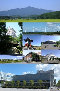
Akita 'Autumn field' is the capital city of Akita Prefecture, Japan, and has been designated a core city since 1 April 1997. As of 1 January 2020, the city has an estimated population of 305,625, 136,628 households and a population density of 340 persons per km2. The total area of the city is 906.07 square kilometres (349.84 sq mi).

<span class="mw-page-title-main">Tōhoku region</span> Northeastern portion of Honshu island, Japan

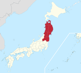
The Tōhoku region, Northeast region, or Northeast Japan consists of the northeastern portion of Honshu, the largest island of Japan. This traditional region consists of six prefectures (ken): Akita, Aomori, Fukushima, Iwate, Miyagi, and Yamagata.

<span class="mw-page-title-main">Yuzawa, Akita</span> City in Tōhoku, Japan

Yuzawa is a city located in Akita Prefecture, Japan. As of 31 December 2019, the city had an estimated population of 44,346 in 17,789 households, and a population density of 56 persons per km². The total area of the city is 790.91 km2 (305.37 sq mi). Yuzawa claims to be the birthplace of the famous Heian period poet Ono no Komachi.

<span class="mw-page-title-main">Kazuno, Akita</span> City in Tōhoku, Japan

Kazuno is a city located in Akita Prefecture, Japan. As of 30 April 2019, the city had an estimated population of 30.715, and a population density of 43 persons per km² in 12.970 households. The total area of the city is 707.52 square kilometres.

<span class="mw-page-title-main">Mamurogawa</span> Town in Tōhoku, Japan

Mamurogawa is a town located in Yamagata Prefecture, Japan. As of 29 February 2020, the town has an estimated population of 7,506 in 2678 households, and a population density of 20 persons per km². The total area of the town is 374.29 square kilometres (145 sq mi).

<span class="mw-page-title-main">Shizukuishi</span> Town in Tōhoku, Japan

Shizukuishi is a town located in Iwate Prefecture, Japan. As of 31 March 2020, the town had an estimated population of 16,263 in 6354 households, and a population density of 27 persons per km². The total area of the town is 608.82 square kilometres (235.07 sq mi).

<span class="mw-page-title-main">Nishimeya</span> Village in Tōhoku, Japan

Nishimeya is a village located in Aomori Prefecture, Japan. As of 1 April 2020, the village had an estimated population of 1340 in 556 households, and a population density of 5.4 persons per km2. The total area of the village is 246.02 square kilometres (94.99 sq mi).

<span class="mw-page-title-main">Nishiwaga</span> Town in Tōhoku, Japan

Nishiwaga is a town in Iwate Prefecture, Japan. As of 31 March 2020, the town had an estimated population of 5,468 in 2279 households, and a population density of 9 persons per km². The total area of the town is 590.74 square kilometres (228.09 sq mi). The total area was 825.97 square kilometres (318.91 sq mi).

<span class="mw-page-title-main">Omono River</span> River in Akita prefecture, Japan

The Omono River is located in Akita Prefecture, Japan. The river flows from Mount Daisen on the border of Akita Prefecture with Miyagi and Yamagata Prefectures in the city of Yuzawa and drains into the Sea of Japan at the city of Akita. The river's drainage basin is essentially the entire southern half of Akita Prefecture. The river is free of dams for its entire length. It is regarded as a "first class river" in the Japanese river classification system.

<span class="mw-page-title-main">Katagami, Akita</span> City in Tōhoku, Japan

Katagami is a city located in Akita Prefecture, Japan. As of 31 December 2019, the city had an estimated population of 32,858 in 13,897 households, and a population density of 330 persons per km². The total area of the city is 97.96 square kilometres (37.82 sq mi).

<span class="mw-page-title-main">Namahage</span> Japanese folklore character associated with new years ritual

The Namahage (生剥) are demonlike beings portrayed by men wearing hefty oni (ogre) masks and traditional straw capes (mino) during a New Year's ritual, in local northern Japanese folklore of the Oga Peninsula area of Akita Prefecture.

Kitakami Line

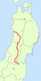
The Kitakami Line is a railway line in Japan. Part of the East Japan Railway Company system, it connects Kitakami Station in Kitakami, Iwate Prefecture to Yokote Station in Yokote, Akita Prefecture, acting as a connecting line between the Ōu Main Line to the Tōhoku Main Line. It connects with the Tōhoku Shinkansen and Tohoku Main Line at Kitakami Station, and the Ōu Main Line at Yokote Station.

<span class="mw-page-title-main">Japan National Route 13</span> National highway in Japan

National Route 13 is a highway in Japan on the island of Honshū which runs from Fukushima in Fukushima Prefecture to Akita in Akita Prefecture.

National Route 46 is a national highway of Japan that connects the capital cities of Iwate Prefecture and Akita Prefecture, Morioka and Akita. It has a total length of 121.4 kilometers (75.4 mi).

National Route 101 is a national highway of Japan connecting the capitals of Aomori and Akita prefectures, Aomori and Akita in northern Japan, with a total length of 241.6 kilometers (150.1 mi). The majority of the highway travels along the coast of the Sea of Japan, paralleling the more inland National Route 7. The present-day highway largely follows the path of the Ōmagoe-kaidō, an Edo period road that linked the Kubota and Hirosaki feudal domains.

National Route 105 is a national highway of Japan that traverses the prefecture of Akita in a southwest–northeast routing. It connects the city of Kitaakita in north-central Akita Prefecture and Yurihonjō on the prefecture's southwestern coast. It has a total length of 170.0 kilometers (105.6 mi).

<span class="mw-page-title-main">Norihisa Satake</span> Japanese politician

Norihisa Satake is a Japanese politician. A former two-term mayor of Akita City in Akita Prefecture, first elected in 2001, he is currently the Governor of Akita Prefecture after winning election on April 12, 2009. He is the 21st head of the North Satake branch of the Satake clan.

Tohoku Soccer League (東北社会人サッカーリーグ) is a Japanese football league covering the Tōhoku region, the 6 prefectures of Akita, Aomori, Fukushima, Iwate, Miyagi and Yamagata. It is one of the nine Japanese Regional Leagues, the fifth and sixth league levels in the Japanese association football league system.

References

  1. 1 2 3 4 5 6 7 8 9 10 11 12 13 14 15 16 17 18 19 20 21 22 GEOnet Names Server, Wikidata   Q1194038