Graphs are unavailable due to technical issues. There is more info on Phabricator and on MediaWiki.org. |
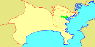
Map of dams in Kanagawa Prefecture(See Wikidata query)
The following is a list of dams in Kanagawa Prefecture, Japan.
Graphs are unavailable due to technical issues. There is more info on Phabricator and on MediaWiki.org. |
The following is a list of dams in Kanagawa Prefecture, Japan.
| Name | Location | Opened | Height (metres) | Image |
|---|---|---|---|---|
| Doshi Dam | 35°33′2″N 139°8′0″E | 1955 | 32.8 |  |
| Honzawa Dam | 35°36′28″N 139°16′32″E [1] | 1965 | 73 |  |
| Ishigoya Dam | 35°32′20″N 139°15′21″E | 2000 | 34.5 |  |
| Iizumi Intake Weir | 35°16′22″N 139°9′58″E [1] | |||
| Kurokura Dam | 35°27′13″N 139°7′10″E [1] |  | ||
| Miho Dam | 35°24′37″N 139°2′30″E | 1978 | 95 |  |
| Miyagase Dam | 35°32′31″N 139°14′56″E | 2000 | 156 |  |
| Numamoto Dam | 35°36′8″N 139°13′49″E [1] | 1943 | 34.5 |  |
| Ohmatazawa Dam | 35°26′6″N 139°0′53″E | 1917 | 18.7 | |
| Sagami Dam | 35°36′56″N 139°11′43″E | 1947 | 58.4 |  |
| Sagamihara Chindenti Dam | 35°32′3″N 139°23′15″E | 1954 | 19.5 | |
| Shiroyama Dam | 35°35′9″N 139°17′22″E | 1965 | 75 |  |

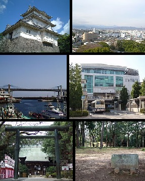
Kanagawa Prefecture is a prefecture of Japan located in the Kantō region of Honshu. Kanagawa Prefecture is the second-most populous prefecture of Japan at 9,221,129 and third-densest at 3,800 inhabitants per square kilometre (9,800/sq mi). Its geographic area of 2,415 km2 (932 sq mi) makes it fifth-smallest. Kanagawa Prefecture borders Tokyo to the north, Yamanashi Prefecture to the northwest and Shizuoka Prefecture to the west.

The Kantō region is a geographical region of Honshu, the largest island of Japan. In a common definition, the region includes the Greater Tokyo Area and encompasses seven prefectures: Gunma, Tochigi, Ibaraki, Saitama, Tokyo, Chiba, and Kanagawa. Slightly more than 45 percent of the land area within its boundaries is the Kantō Plain. The rest consists of the hills and mountains that form land borders with other regions of Japan.

Ōi is a town located in Kanagawa Prefecture, Japan. As of 1 October 2023, the town had an estimated population of 17,313 and a population density of 1201 persons per km². The total area of the town is 14.41 square kilometres (5.56 sq mi).

Aikawa is a town located in Kanagawa Prefecture, Japan. As of 1 April 2021, the town had an estimated population of 39,763 and a population density of 1200 persons per km². The total area of the town is 34.29 square kilometres (13.24 sq mi).

Kiyokawa is a village located in Kanagawa Prefecture, Japan. As of 1 October 2023, the village had an estimated population of 2,912 and a population density of 40,8 persons per km². The total area of the village is 71.29 square kilometres (27.53 sq mi).
Kanagawa-ku (神奈川区) is one of the 18 wards of the city of Yokohama in Kanagawa Prefecture, Japan. As of 2010, the ward had an estimated population of 230,401 and a density of 9,650 persons per km2. The total area was 23.88 km2.
Odawara is a city in Kanagawa Prefecture, Japan. As of 1 June 2021, the city had an estimated population of 188,482 and a population density of 1,700 persons per km2. The total area of the city is 113.79 square kilometres (43.93 sq mi).
TV Kanagawa is an independent television station in Japan serving Kanagawa Prefecture and parts of the Greater Tokyo Area with favorable reception. The station was founded on April 20, 1971 and began broadcasting on April 1, 1972. Its call sign is JOKM-DTV and occupies the UHF channel 18 on the airwaves.

The Sameura Dam is a dam on the Yoshino River on the island of Shikoku, Japan, completed in 1975. It has the largest storage capacity in Shikoku. The dam holds back a reservoir, named Lake Sameura

The Sagami River is a river in Kanagawa and Yamanashi Prefectures on the island of Honshū, Japan.

The Shiroyama Dam is a multi-purpose dam on the main stream Sagami River in Sagamihara, Kanagawa Prefecture on the island of Honshū, Japan.

The Miyagase Dam is a dam on the Nakatsu River, a main tributary of the Sagami River in Aikō District, Kanagawa Prefecture, Japan. It straddles the border between the village of Kiyokawa, town of Aikawa and the former town of Tsukui.
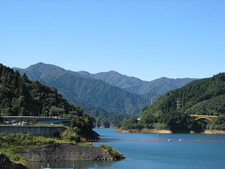
Tanzawa-Ōyama Quasi-National Park is a quasi-national park in the Kantō region of Honshū in Japan. It is rated a protected landscape according to the IUCN. The park includes the Tanzawa Mountains, Miyagase Dam and its surrounding forests, Hayato Great Falls, and the religious sites of Mount Ōyama in the mountains of western Kanagawa Prefecture.

The Sagami Dam is a multi-purpose dam on the main stream Sagami River in Sagamihara, Kanagawa Prefecture on the island of Honshū, Japan.

The Miho Dam is a multi-purpose dam on the Kawauchi River, a tributary stream of the Sakawa River in the town of Yamakita, Ashigarakami District, Kanagawa Prefecture on the island of Honshū, Japan. The dam is located within the borders of the Tanzawa-Ōyama Quasi-National Park.

Doshi Dam(Japanese: 道志ダム) is a gravity dam located in Kanagawa Prefecture in Japan. The dam is used for power production. The catchment area of the dam is 112.5 km2. The dam impounds about 14 ha of land when full and can store 1525 thousand cubic meters of water. The construction of the dam was started on 1952 and completed in 1955.
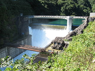
Miyagase Fuku Dam(Japanese: 石小屋ダム) is a gravity dam located in Kanagawa Prefecture in Japan. The dam is used for flood control, water supply and power production. The catchment area of the dam is 1.1 km2. The dam impounds about 4 ha of land when full and can store 557 thousand cubic meters of water. The construction of the dam was started on 1971 and completed in 2000.
Ohmatazawa Dam(Japanese: 大又沢ダム) is a gravity dam located in Kanagawa Prefecture in Japan. The dam is used for power production. The catchment area of the dam is 16 km2. The dam impounds about 2 ha of land when full and can store 90 thousand cubic meters of water. The construction of the dam was started on 1914 and completed in 1917.
Sagamihara Chindenti(Japanese: 相模原沈でん池) is an earthfill dam located in Kanagawa Prefecture in Japan. The dam is used for water supply. The dam impounds about 12 ha of land when full and can store 883 thousand cubic meters of water. The construction of the dam was completed in 1954.