List of dams in Kagoshima Prefecture

Last updated

Map of dams in Kagoshima Prefecture.(See Wikidata query)

The following is a list of dams in Kagoshima Prefecture, Japan.

Contents

List

NameLocationOpenedHeight (metres)Image
Arase Dam   OOjs UI icon edit-ltr-progressive.svg 31°20′18″N 131°0′41″E 201865.6
Boma Dam   OOjs UI icon edit-ltr-progressive.svg 27°47′55″N 128°58′9″E 196317
Ichiki Dam  OOjs UI icon edit-ltr-progressive.svg 31°43′2″N 130°22′0″E [1] 41 [2]
Isenchubu Dam   OOjs UI icon edit-ltr-progressive.svg 27°42′23″N 128°56′39″E [1] 198729
Jisso Dam   OOjs UI icon edit-ltr-progressive.svg 32°6′35″N 130°36′6″E 194623.3
Kawanabe Dam   OOjs UI icon edit-ltr-progressive.svg 31°26′42″N 130°26′44″E 200253.5 Kawanabe-2880-r1.JPG
Kihoku-damu   OOjs UI icon edit-ltr-progressive.svg 31°32′55″N 130°54′3″E [1] 200541.9
Kinpo Dam   OOjs UI icon edit-ltr-progressive.svg 31°27′16″N 130°23′58″E [1] 200357.9
Kiyoura Dam   OOjs UI icon edit-ltr-progressive.svg 31°45′22″N 130°28′9″E [1] 197438.1
Kougawa Dam   OOjs UI icon edit-ltr-progressive.svg 32°3′53″N 130°24′46″E 42 [2] Kougawa-2868-r1.JPG
Kushikino Dam   OOjs UI icon edit-ltr-progressive.svg 31°44′5″N 130°19′34″E [1] 197031.7
Matsumoto Dam   OOjs UI icon edit-ltr-progressive.svg 31°33′54″N 130°25′2″E [1] 200238.5
Mitarai Dam   OOjs UI icon edit-ltr-progressive.svg 32°1′30″N 130°18′13″E [1] 198243.4
Nagayoshi Dam   OOjs UI icon edit-ltr-progressive.svg 31°32′59″N 130°24′57″E [1] 197937
Nakadake Dam   OOjs UI icon edit-ltr-progressive.svg 31°38′32″N 131°5′23″E [1] 200769.9
Nanbu Dam   OOjs UI icon edit-ltr-progressive.svg 27°47′23″N 128°56′51″E [1] 196925.2
Nishinotani Dam   OOjs UI icon edit-ltr-progressive.svg 31°36′3″N 130°30′8″E 201221.5
Odate Dam   OOjs UI icon edit-ltr-progressive.svg 30°20′14″N 130°35′30″E [1] 196353.5
Okawa Dam   OOjs UI icon edit-ltr-progressive.svg 28°20′29″N 129°29′1″E 198649.2 Okawa Dam in Amami, Kagoshima.jpg
Saikyo Dam   OOjs UI icon edit-ltr-progressive.svg 30°45′52″N 131°1′55″E [1] 198729.7 Xi Jing damuDSC01143.JPG
Seibu Dam   OOjs UI icon edit-ltr-progressive.svg 27°49′18″N 128°55′56″E 196816.7
Sendaigawa Dam   OOjs UI icon edit-ltr-progressive.svg 31°57′32″N 130°29′57″E 196424 Sendaigawa No. 2 Dam.jpg
Shinrei Dam   OOjs UI icon edit-ltr-progressive.svg 27°45′9″N 128°59′51″E [1] 198133.8
Shinsumiyogawa Dam   OOjs UI icon edit-ltr-progressive.svg 28°17′20″N 129°23′10″E [1] 25 [2] Shinsumiyogawa Dam 1977.jpg
Suno Dam   OOjs UI icon edit-ltr-progressive.svg 28°28′25″N 129°41′56″E [1] 199827.5
Takakuma Dam   OOjs UI icon edit-ltr-progressive.svg 31°30′30″N 130°51′34″E 196747 TakakumaDam.jpg
Takamatsu Dam   OOjs UI icon edit-ltr-progressive.svg 32°1′26″N 130°14′53″E [1] 196937
Takanosu Dam   OOjs UI icon edit-ltr-progressive.svg 32°12′10″N 130°10′58″E 198828.9
Takaono Dam   OOjs UI icon edit-ltr-progressive.svg 32°1′41″N 130°18′36″E 35 [2] Takaono-2858-r1.JPG
Take Dam   OOjs UI icon edit-ltr-progressive.svg 32°1′18″N 130°17′20″E [1] 200329.7
Takeyama Dam   OOjs UI icon edit-ltr-progressive.svg 31°48′47″N 130°39′55″E [1] 198754.5
Tanikawauchi Dam   OOjs UI icon edit-ltr-progressive.svg 31°44′3″N 130°56′24″E 201258.5
Tobu Dam   OOjs UI icon edit-ltr-progressive.svg 27°41′55″N 128°57′30″E 197019
Tokunoshima Dam   OOjs UI icon edit-ltr-progressive.svg 27°46′30″N 128°55′39″E 201556.3
Tsuruda Dam   OOjs UI icon edit-ltr-progressive.svg 31°59′19″N 130°29′38″E Tsuruta-2861-r1.JPG
Yamada Dam  OOjs UI icon edit-ltr-progressive.svg 27°21′44″N 128°34′8″E [1]
Yamato Dam   OOjs UI icon edit-ltr-progressive.svg 28°20′34″N 129°23′15″E 200645 Yamato Dam1.JPG

See also

Related Research Articles

<span class="mw-page-title-main">Kagoshima</span> Core city in Kyushu, Japan

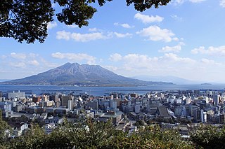
Kagoshima, officially Kagoshima City, is the capital city of Kagoshima Prefecture, Japan. Located at the southwestern tip of the island of Kyūshū, Kagoshima is the largest city in the prefecture by some margin. It has been nicknamed the "Naples of the Eastern world" for its bay location, hot climate, and emblematic stratovolcano, Sakurajima. The city was officially founded on April 1, 1889. It merged with Taniyama City on April 29, 1967 and with Yoshida Town, Sakurajima Town, Kiire Town, Matsumoto Town and Kōriyama Town on November 1, 2004.

<span class="mw-page-title-main">Kagoshima Prefecture</span> Prefecture of Japan

Kagoshima Prefecture is a prefecture of Japan located on the island of Kyushu and the Ryukyu Islands. Kagoshima Prefecture has a population of 1,564,175 and has a geographic area of 9,187 km2. Kagoshima Prefecture borders Kumamoto Prefecture to the north and Miyazaki Prefecture to the northeast.

Ōshima, Oshima, Ooshima or Ohshima may refer to:

<span class="mw-page-title-main">Kōgawa Dam</span> Dam in Kagoshima Prefecture, Japan

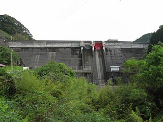
Kōgawa Dam is a dam in Kagoshima Prefecture, Japan, completed in 1973.

<span class="mw-page-title-main">Sendaigawa Dam</span> Dam in Kagoshima Prefecture, Japan

Sendaigawa Dam or Sendaigawa No.2 Dam is a dam in Kagoshima Prefecture, Japan, completed in 1964. The dam is a gravity dam, built for the purpose of generating hydroelectric power.

<span class="mw-page-title-main">Shinsumiyogawa Dam</span> Dam in Kagoshima Prefecture, Japan

Shinsumiyogawa Dam is a dam in Kagoshima Prefecture, Japan, completed in 1959.

<span class="mw-page-title-main">Takaono Dam</span> Dam in Kagoshima Prefecture, Japan

Takaono Dam is a dam in Kagoshima Prefecture, Japan, completed in 1966.

<span class="mw-page-title-main">Tsuruda Dam</span> Dam in Kagoshima Prefecture, Japan

Tsuruda Dam is a dam in Kagoshima Prefecture, Japan, completed in 1965.

Matsumoto Dam(Japanese: 松元ダム) is a gravity dam located in Kagoshima, Kagoshima Prefecture in Japan. The dam is used for irrigation. The catchment area of the dam is 2.9 km2. The dam impounds about 6 ha of land when full and can store 640 thousand cubic meters of water. The construction of the dam was started on 1986 and completed in 2002.

References

  1. 1 2 3 4 5 6 7 8 9 10 11 12 13 14 15 16 17 18 19 20 Geographic Names Server, Wikidata   Q1194038
  2. 1 2 3 4 Dams in Japan, Japan Dam Foundation, Wikidata   Q113763464