Graphs are unavailable due to technical issues. There is more info on Phabricator and on MediaWiki.org. |
Map of dams in Tochigi Prefecture.(See Wikidata query)
The following is a list of dams in Tochigi Prefecture, Japan.
Graphs are unavailable due to technical issues. There is more info on Phabricator and on MediaWiki.org. |
The following is a list of dams in Tochigi Prefecture, Japan.
| Name | Location | Started | Opened | Height | Length | Image | DiJ number |
|---|---|---|---|---|---|---|---|
| Akagawa Dam | 36°37′12″N 139°47′26″E [1] | 1965 | 1970 | 17.5 m (57 ft) | 221 m (725 ft) | 0565 | |
| Ashio Dam | 36°40′37″N 139°26′22″E |  | |||||
| Chuzenji Dam | 36°44′19″N 139°29′57″E | 1953 | 1959 | 6.4 m (21 ft) | 25.1 m (82 ft) |  | |
| Chiburi Dam | 37°5′40″N 140°5′57″E | 1966 | 1971 | 23 m (75 ft) | 130 m (430 ft) |  | 0566 |
| Dorobu Dam | 36°52′31″N 139°35′4″E [1] | 1962 | 1963 | 21.6 m (71 ft) | 56 m (184 ft) |  | 0558 |
| Higashiarakawa Dam | 36°50′50″N 139°49′43″E [1] | 1974 | 1990 | 70 m (230 ft) | 290 m (950 ft) |  | 0577 |
| Hokigawa Dam | 36°57′57″N 139°51′25″E |  | |||||
| Ikari Dam | 36°54′11″N 139°42′19″E [1] | 1941 | 1956 | 112 m (367 ft) | 267 m (876 ft) |  | 0559 |
| Imaichi Dam | 36°49′32″N 139°39′59″E [1] | 1979 | 1986 | 75.5 m (248 ft) [2] |  | 0579 | |
| Itamuro Dam | 37°3′25″N 139°55′51″E | 1968 | 1973 | 16.8 m (55 ft) | 76 m (249 ft) |  | 0569 |
| Kawaji Dam | 36°53′56″N 139°41′34″E [1] | 140 m (460 ft) [2] |  | 0571 | |||
| Kawamata Dam | 36°52′41″N 139°31′13″E [1] | 1957 | 1966 | 117 m (384 ft) | 131 m (430 ft) |  | 0563 |
| Koami Dam | 36°53′2″N 139°42′9″E | 1953 | 1958 | 23.5 m (77 ft) | 128 m (420 ft) |  | 0560 |
| Koshin Dam | 36°37′51″N 139°25′15″E | 1975 | 1985 | 29 m (95 ft) | 55.9 m (183 ft) |  | 0585 |
| Kurobe Dam | 36°52′9″N 139°36′36″E | 28.7 m (94 ft) [2] |  | 0556 | |||
| Kuriyama Dam | 36°51′8″N 139°39′11″E [1] | 1981 | 1985 | 97.5 m (320 ft) [2] |  | 0578 | |
| Kuriyasawa Dam | 36°38′32″N 139°48′20″E [1] | 15 m (49 ft) [2] | 3674 | ||||
| Matsudagawa Dam | 36°25′35″N 139°25′30″E [1] | 1981 | 1995 | 56 m (184 ft) | 228 m (748 ft) |  | 0581 |
| Mikawasawa Dam | 36°57′17″N 139°33′0″E [1] | 1984 | 2003 | 48.5 m (159 ft) | 97.5 m (320 ft) | 0588 | |
| Miyama Dam | 37°5′22″N 139°54′17″E [1] | 1968 | 1973 | 75.5 m (248 ft) | 333.8 m (1,095 ft) |  | 0568 |
| Nishigoya Dam | 36°47′42″N 139°45′13″E [1] | 1962 | 1963 | 21.5 m (71 ft) | 189.7 m (622 ft) |  | 0562 |
| Nakaiwa Dam | 36°47′12″N 139°42′14″E | 1922 | 1924 | 26.3 m (86 ft) | 107.9 m (354 ft) |  | 0557 |
| Nakauchi Dam | 36°57′46″N 139°37′17″E |  | |||||
| Nanma Dam | 36°33′1″N 139°40′10″E | 1969 | 86.5 m (284 ft) | 359 m (1,178 ft) |  | 0576 | |
| Nishiarakawa Dam | 36°49′1″N 139°48′30″E [1] | 1962 | 1968 | 43.5 m (143 ft) | 116 m (381 ft) |  | 0564 |
| Nishigoya Dam | 36°47′42″N 139°45′13″E [1] | 1962 | 1963 | 21.5 m (71 ft) | 189.7 m (622 ft) | | 0562 |
| Numappara Dam | 37°6′14″N 139°55′42″E [3] | 1969 | 1973 | 38 m (125 ft) | 1,597 m (5,240 ft) |  | 0567 |
| Ogoto Dam | 36°24′35″N 140°6′14″E [1] | 1976 | 1986 | 27.7 m (91 ft) | 150 m (490 ft) | 0572 | |
| Omuro Dam | 36°43′11″N 139°45′7″E [1] | ||||||
| Sabigawa Dam | 36°59′44″N 139°52′6″E [1] | 1994 | 1994 | 104 m (341 ft) [2] |  | 0583 | |
| Shiobara Dam | 36°57′7″N 139°53′4″E [1] | 1969 | 1978 | 60 m (200 ft) | 240 m (790 ft) |  | 0570 |
| Sunokobashi Tailings Dam | 36°38′48″N 139°26′20″E |  | |||||
| Sakasegawa Dam | 36°51′3″N 139°41′10″E | 1911 | 1912 | 18.2 m (60 ft) | 121.2 m (398 ft) |  | 0555 |
| Shioda Dam | 36°49′34″N 139°52′30″E [1] | 1977 | 2000 | 26.1 m (86 ft) | 218 m (715 ft) |  | 0573 |
| Shiota Choseichi Dam | 36°36′57″N 140°6′56″E | 1982 | 2000 | 29 m (95 ft) | 460 m (1,510 ft) | 3153 | |
| Sugamata Choseichi Dam | 36°33′1″N 140°9′5″E | 1982 | 2002 | 28.4 m (93 ft) | 105 m (344 ft) | 3279 | |
| Terayama Dam | 36°50′50″N 139°51′52″E [1] | 1972 | 1984 | 62.2 m (204 ft) | 260 m (850 ft) |  | 0574 |
| Yanome Dam | 37°4′7″N 140°9′6″E [1] | 1976 | 1990 | 29 m (95 ft) | 187 m (614 ft) |  | 0575 |
| Yashio Dam | 36°59′7″N 139°51′10″E [1] | 1986 | 1992 | 90.5 m (297 ft) | 263 m (863 ft) | 0582 | |
| Yunishigawa Dam | 36°56′10″N 139°39′48″E [2] | 1982 | 2012 | 119 m (390 ft) [2] |  | 0584 |

Tochigi Prefecture is a landlocked prefecture of Japan located in the Kantō region of Honshu. Tochigi Prefecture has a population of 1,897,649 and has a geographic area of 6,408 km². Tochigi Prefecture borders Fukushima Prefecture to the north, Gunma Prefecture to the west, Saitama Prefecture to the south, and Ibaraki Prefecture to the southeast.
Ibaraki Prefecture is a prefecture of Japan located in the Kantō region of Honshu. Ibaraki Prefecture has a population of 2,828,086 and has a geographic area of 6,097.19 square kilometres. Ibaraki Prefecture borders Fukushima Prefecture to the north, Tochigi Prefecture to the northwest, Saitama Prefecture to the southwest, Chiba Prefecture to the south, and the Pacific Ocean to the east.

The Kantō region is a geographical region of Honshu, the largest island of Japan. In a common definition, the region includes the Greater Tokyo Area and encompasses seven prefectures: Gunma, Tochigi, Ibaraki, Saitama, Tokyo, Chiba, and Kanagawa. Slightly more than 45 percent of the land area within its boundaries is the Kantō Plain. The rest consists of the hills and mountains that form land borders with other regions of Japan.

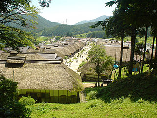
Tochigi is a city located in Tochigi Prefecture, in the northern Kantō region of Japan. As of 1 June 2023, the city had an estimated population of 151,842 in 66,018 households, and a population density of 458 persons per km². The total area of the city is 331.50 square kilometres (127.99 sq mi). Because the city escaped war damage during World War II, many historical temples, traditional shops and kura remain in the city center. The city was awarded the "Utsukushii-machinami Taisho" prize from the Ministry of Land, Infrastructure, Transport and Tourism in 2009.
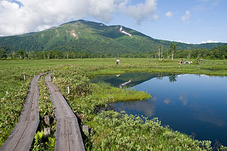
Katashina is a village located in Gunma Prefecture, Japan. As of 31 October 2020, the village had an estimated population of 4,314 in 1694 households, and a population density of 11 persons per km². The total area of the village is 391.76 square kilometres (151.26 sq mi). m². Much of the village is within the borders of Oze National Park.
Shimogō is a town located in Fukushima Prefecture, Japan. As of 1 April 2020, the town had an estimated population of 5,517 in 2216 households and a population density of 17 persons per km2. The total area of the town was 317.04 square kilometres (122.41 sq mi).

Nishigō is a village located in Fukushima Prefecture, Japan. As of 1 March 2020, the village had an estimated population of 20,351 in 7618 households and a population density of 110 persons per km2. The total area of the village was 192.06 square kilometres (74.15 sq mi)..