List of dams in Saga Prefecture

Last updated

Map of dams in Saga Prefecture.(See Wikidata query)

The following is a list of dams in Saga Prefecture, Japan.

Contents

Hokuzan Dam, taken in 2008 Hokuzan-2524-r1.JPG
Hokuzan Dam, taken in 2008

List

NameLocationConstruction startedOpenedHeight (metres)Length (metres)DiJ no.
Agekura Dam   OOjs UI icon edit-ltr-progressive.svg 33°25′23″N 129°51′8″E [1] 1972199219.6 [2] 196.8 2547
Akasaka Dam   OOjs UI icon edit-ltr-progressive.svg 33°24′48″N 129°53′47″E [1] 1972199230.4256.4 2548
Amagase Dam   OOjs UI icon edit-ltr-progressive.svg 33°14′58″N 130°6′25″E [1] 1972198239.4270 2541
Arita Dam   OOjs UI icon edit-ltr-progressive.svg 33°11′54″N 129°53′43″E 1958196127.5108 2526
Asahi Dam  OOjs UI icon edit-ltr-progressive.svg 33°13′5″N 130°2′38″E [1]
Banzai Tameike Dam   OOjs UI icon edit-ltr-progressive.svg 33°1′54″N 130°4′47″E 197317.5128 2531
Fuchinoo Dam   OOjs UI icon edit-ltr-progressive.svg 33°10′53″N 129°59′50″E 1979198029138 2556
Fujinohira Dam   OOjs UI icon edit-ltr-progressive.svg 33°27′53″N 129°53′7″E [1] 1990200258.4296.2 2549
Fukaura Dam   OOjs UI icon edit-ltr-progressive.svg 33°8′17″N 130°6′11″E 1977198926121 2546
Furukoba Dam   OOjs UI icon edit-ltr-progressive.svg 33°10′2″N 129°54′41″E [1] 1973199826.8193 2542
Hanatori Tameike Dam   OOjs UI icon edit-ltr-progressive.svg 33°3′32″N 130°7′8″E 196922.5176 2530
Hansho Dam   OOjs UI icon edit-ltr-progressive.svg 33°13′35″N 130°0′46″E [1] 1973197829.4156 2536
Hatcho Dam   OOjs UI icon edit-ltr-progressive.svg 33°18′48″N 130°8′56″E [1] 1973198224.6346.6 2538
Hinomine Dam   OOjs UI icon edit-ltr-progressive.svg 33°10′59″N 129°55′38″E [1] 1982200128.4112 2560
Hirakoba Dam   OOjs UI icon edit-ltr-progressive.svg 33°25′55″N 129°56′43″E [1] 1972198329.5117 2543
Hokuzan Dam   OOjs UI icon edit-ltr-progressive.svg 33°26′2″N 130°14′14″E 1950195659.3 [3] 180 [3] 2524
Ikisa Dam   OOjs UI icon edit-ltr-progressive.svg 33°22′3″N 130°2′35″E [1] 1969197958.5203 2540
Inubashiri Dam  OOjs UI icon edit-ltr-progressive.svg 33°10′35″N 129°58′31″E [1]
Iwayagawauchi Dam   OOjs UI icon edit-ltr-progressive.svg 33°4′4″N 129°59′0″E [1] 1967197359.5192 2533
Kasegawa Dam   OOjs UI icon edit-ltr-progressive.svg 33°23′22″N 130°13′1″E 1973201197, 99 [4] 454.5, 456 [4] 2553
Karitate Dam   OOjs UI icon edit-ltr-progressive.svg 33°10′54″N 129°55′46″E [1] 1982200128.4177 2559
Kawachi Dam   OOjs UI icon edit-ltr-progressive.svg 33°24′24″N 130°29′21″E [1] 197135153 2528
Kishikawa Dam   OOjs UI icon edit-ltr-progressive.svg 33°19′1″N 130°7′31″E [1] 196226.566 2527
Kitaura Tameike Dam   OOjs UI icon edit-ltr-progressive.svg 33°18′29″N 130°12′32″E 194817.9192 2522
Kogo-ike Dam   OOjs UI icon edit-ltr-progressive.svg 33°19′57″N 130°19′49″E 194816100 2523
Kyuragi Dam   OOjs UI icon edit-ltr-progressive.svg 33°19′41″N 130°6′8″E [1] 19731986117390.4 2545
Kyuragigawa Choseichi Dam   OOjs UI icon edit-ltr-progressive.svg 33°20′56″N 130°6′52″E [1] 1918193015.5 [5] 59.8 2515
Motobe Dam   OOjs UI icon edit-ltr-progressive.svg 33°16′1″N 130°0′34″E [1] 1979198842.1130 2555
Nagahama Dam  OOjs UI icon edit-ltr-progressive.svg 33°16′27″N 129°50′53″E [1]
Nakakoba Dam   OOjs UI icon edit-ltr-progressive.svg 33°2′30″N 130°4′13″E 1978200769.5265 2552
Nanamagari Tameike Dam   OOjs UI icon edit-ltr-progressive.svg 33°1′51″N 130°7′19″E 197315.3133 2532
Niwaki Dam   OOjs UI icon edit-ltr-progressive.svg 33°7′34″N 129°57′36″E [1] 1985199426.2130 2557
Ohura Dam   OOjs UI icon edit-ltr-progressive.svg 32°58′2″N 130°10′6″E [1] 1970198745160 2534
Ryumon Dam   OOjs UI icon edit-ltr-progressive.svg 33°12′43″N 129°52′41″E [1] 1968197542.2150 2535
Sasahara Tameike Dam   OOjs UI icon edit-ltr-progressive.svg 33°2′34″N 130°7′17″E 197026.3175 2529
Tenzan Dam   OOjs UI icon edit-ltr-progressive.svg 33°20′33″N 130°7′56″E [1] 1978198669380 2550
Uchiage Dam   OOjs UI icon edit-ltr-progressive.svg 33°30′27″N 129°54′8″E [1] 1972199236.1181.8 2539
Ushirogawachi Dam   OOjs UI icon edit-ltr-progressive.svg 33°26′45″N 129°55′19″E [1] 1972199242.2250 2544
Yokotake Dam   OOjs UI icon edit-ltr-progressive.svg 33°3′34″N 130°2′17″E [1] 1973200157249 2551
Yahazu Dam   OOjs UI icon edit-ltr-progressive.svg 33°8′34″N 129°56′59″E [1] 1981199332.5199 2558

See also

Related Research Articles

<span class="mw-page-title-main">Yōjirō Ishizaka</span>

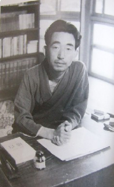
Yōjirō Ishizaka was a Japanese writer of short stories and novels.

<span class="mw-page-title-main">Sagan Tosu</span> Japanese football club

Sagan Tosu is a Japanese professional football club based in Tosu, Saga Prefecture. The club plays in the J1 League, which is the top tier of football in the country.

<i>Kamairicha</i> Japanese green tea

Kamairicha (釜炒り茶) is a Japanese green tea produced by pan-roasting or pan-firing tea leaves during the early stages of production. It is most commonly produced in the western region of Japan. Kamairicha has a mildly roasted flavour with more sweet and fresh notes than bitter ones.

<span class="mw-page-title-main">Bandai-Asahi National Park</span> National park in Tōhoku, Japan

Bandai-Asahi National Park is a national park in the Tōhoku region, Honshū, Japan. The park site straddles over Fukushima Prefecture, Yamagata Prefecture, and Niigata Prefecture. The park was designated as a national park on September 5, 1950. The park encompasses 186,404 ha of land, consisting of three independent units: the Dewasanzan-asahi Region, Iide Region, and Bandaiazuma-Inawashiro Region.

<span class="mw-page-title-main">Kazuhiro Haraguchi</span> Japanese politician (born 1959)

Kazuhiro Haraguchi is a Japanese politician of the Democratic Party for the People and a member of the House of Representatives in the Diet.

<span class="mw-page-title-main">Tokyo Metropolitan Art Museum</span> Museum in Tokyo, Japan

The Tokyo Metropolitan Art Museum is a museum of art located in Ueno Park, Tokyo, Japan. It is one of Japan's many museums which are supported by a prefectural government. The first public art museum in Japan, it opened in 1926 as the Tokyo Prefectural Art Museum and was renamed in 1943 after Tokyo became a metropolitan prefecture. The museum's current building was constructed in 1975 and designed by modernist architect Kunio Maekawa, remaining one his most well-known works today.

<span class="mw-page-title-main">Tokyo Metropolitan Assembly</span> Prefectural parliament of Tokyo

The Tokyo Metropolitan Assembly is the prefectural parliament of Tokyo Metropolis.

The Journal of the Academic Association of Koreanology in Japan is a Japanese/Korean/English-language scholarly journal published by the Tenri University, a private university in Tenri, Nara Prefecture, Japan. The journal features articles and book reviews of current scholarship in East Asian Studies, focusing on Korean and Japanese history, literature and religion, with occasional coverage of politics and linguistics.

<span class="mw-page-title-main">Higashi-Shimizu Frequency Converter</span> HVDC back-to-back station in Japan

Higashi-Shimizu Frequency Converter is the third facility in Japan for interconnecting the power grid of eastern Japan, which operates at 50 hertz, and that of western Japan, which operates at 60 hertz.

<span class="mw-page-title-main">Yabakei Dam</span> Dam in Ōita Prefecture, Japan

Yabakei Dam is a dam in the Ōita Prefecture, Japan.

<span class="mw-page-title-main">Ikumi Yoshimatsu</span> Japanese actress, stunt woman, author, activist and beauty queen

Ikumi Yoshimatsu is a Japanese actress, stunt woman, book author, opinion leader, social activist and beauty queen who was crowned Miss International 2012 in Okinawa. It was Japan's first Miss International win in the 52-year history of the pageant.

Kouichi Oohori is a Japanese actor. He participated in Gekidan Kenko from 1985 to 1992.

Kosobe ware is a type of Japanese pottery traditionally from Osaka Prefecture.

<span class="mw-page-title-main">Space Operations Group</span> Military unit

The Space Operations Group is a Japan Air and Space Self-Defense Force unit based at Fuchu Air Base in Fuchu, Tokyo. It is responsible for the JASDF's space domain awareness capability, integrating surveillance data from a sensor near Sanyo-Onoda in Yamaguchi Prefecture, along with data supplied by JAXA and the United States Space Force. The unit also conducts satellite navigation and satellite communications for other military units.

References

  1. 1 2 3 4 5 6 7 8 9 10 11 12 13 14 15 16 17 18 19 20 21 22 23 24 25 26 27 28 Geographic Names Server, Wikidata   Q1194038
  2. "Agekura Dam". Structurae .
  3. 1 2 http://www.sa-tochi.jp/construction.html
  4. 1 2 https://www.qsr.mlit.go.jp/kasegawa/learn/mokuteki/syogen.html
  5. "Kyuragigawa Choseichi [Saga Pref.]". Dams in Japan.