List of dams in Mie Prefecture

Last updated

Map of dams in Mie Prefecture.(See Wikidata query)

The following is a list of dams in Mie Prefecture, Japan.

Contents

List

NameLocationOpenedHeight (meters)Image
Ano Dam   OOjs UI icon edit-ltr-progressive.svg 34°48′25″N 136°22′56″E [1] 198973 Mie ken, Tsu shi, Anou Dam - panoramio.jpg
Bandotame Dam   OOjs UI icon edit-ltr-progressive.svg 35°8′54″N 136°34′32″E 196329.5
Erihara Dam   OOjs UI icon edit-ltr-progressive.svg 34°23′16″N 136°47′27″E Erihara-dam 01.JPG
Fudodani Dam   OOjs UI icon edit-ltr-progressive.svg 34°13′26″N 136°8′41″E 196120.5
Hachisu Dam   OOjs UI icon edit-ltr-progressive.svg 34°22′37″N 136°12′32″E 199178 Hachisu-1331-r1.jpg
Hinachi Dam   OOjs UI icon edit-ltr-progressive.svg 34°36′50″N 136°9′19″E [1] 199870.5 1330-r1.jpg
Isaka Dam   OOjs UI icon edit-ltr-progressive.svg 35°2′19″N 136°37′7″E 196634.5 Isaka Dam lake survey 1975.jpg
Kamiji Dam   OOjs UI icon edit-ltr-progressive.svg 34°23′57″N 136°46′57″E [1] 197229.6 Kamiji-dam 01.JPG
Katada Dam   OOjs UI icon edit-ltr-progressive.svg 34°42′51″N 136°24′59″E 192926.6 Pian Tian Zhu Shui Chi .JPG
Kawakami Dam   OOjs UI icon edit-ltr-progressive.svg 34°39′21″N 136°11′10″E 84 Chuan Shang damu001.jpg
Kimigano Dam  OOjs UI icon edit-ltr-progressive.svg 34°35′48″N 136°18′47″E [1] 73 [2]
Kochi Dam   OOjs UI icon edit-ltr-progressive.svg 34°26′20″N 136°48′51″E 196324
Kokatsura-ike Dam   OOjs UI icon edit-ltr-progressive.svg 34°24′51″N 136°29′44″E 189515
Komono Dam  OOjs UI icon edit-ltr-progressive.svg 35°0′5″N 136°29′28″E [1]
Komori Dam   OOjs UI icon edit-ltr-progressive.svg 33°56′5″N 135°55′41″E [1] 34 [2] Komori-1313-r1.jpg
Kuchisubo Dam   OOjs UI icon edit-ltr-progressive.svg 34°5′31″N 136°9′44″E [1] 35 [2] Kuchisubo Dam.jpg
Matsuo Dam   OOjs UI icon edit-ltr-progressive.svg 34°25′24″N 136°50′48″E 196317
Midoro Dam   OOjs UI icon edit-ltr-progressive.svg 34°45′48″N 136°11′42″E 197026.2
Misedani Dam   OOjs UI icon edit-ltr-progressive.svg 34°23′21″N 136°24′4″E 196639 [2] Misedani-dam (Mie) 02.JPG
Miyagawa Choseichi Dam   OOjs UI icon edit-ltr-progressive.svg 35°5′4″N 136°29′45″E 197927
Miyagawa Dam   OOjs UI icon edit-ltr-progressive.svg 34°17′11″N 136°11′46″E [1] 195688.5 Miyagawa-dam (Mie) 01.JPG
Nakaoki-ike Dam   OOjs UI icon edit-ltr-progressive.svg 34°22′57″N 136°22′43″E 199017
Nakazato Dam   OOjs UI icon edit-ltr-progressive.svg 35°13′12″N 136°28′54″E [1] 46 [2] Nakazato-975-ri.JPG
Nameri-ko Dam   OOjs UI icon edit-ltr-progressive.svg 34°35′17″N 136°25′40″E 197328.4
Nanairo Dam   OOjs UI icon edit-ltr-progressive.svg 33°57′37″N 136°0′9″E [1] 196561 [2] Nanairodam.jpg
Nishikomenogawa Dam   OOjs UI icon edit-ltr-progressive.svg 34°50′19″N 136°7′18″E 198218.5
Ohhira-ike Dam   OOjs UI icon edit-ltr-progressive.svg 34°48′39″N 136°16′10″E 197915.1
Saigu Choseichi Dam   OOjs UI icon edit-ltr-progressive.svg 34°30′39″N 136°36′27″E 201116
Sakakibara-ike Dam   OOjs UI icon edit-ltr-progressive.svg 34°41′59″N 136°19′39″E 193918.9
Shorenji Dam   OOjs UI icon edit-ltr-progressive.svg 34°36′15″N 136°7′12″E 197082 Shorenji-1316-r1.jpg
Taketani-ike Dam   OOjs UI icon edit-ltr-progressive.svg 34°50′7″N 136°15′37″E 196022
Takigawa Dam   OOjs UI icon edit-ltr-progressive.svg 34°43′2″N 136°12′53″E [1] 199929.8
Takitani-ike Dam   OOjs UI icon edit-ltr-progressive.svg 34°52′53″N 136°7′4″E 195523.5
Tobakochi Dam   OOjs UI icon edit-ltr-progressive.svg 34°26′25″N 136°48′58″E 39
Yamasato-ohike Dam   OOjs UI icon edit-ltr-progressive.svg 35°9′50″N 136°32′33″E 196322

See also

Related Research Articles

<span class="mw-page-title-main">Mie Prefecture</span> Prefecture of Japan

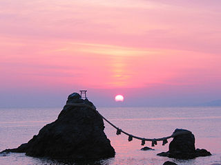
Mie Prefecture is a prefecture of Japan located in the Kansai region of Honshu. Mie Prefecture has a population of 1,781,948 and has a geographic area of 5,774 square kilometers (2,229 sq mi). Mie Prefecture is bordered by Gifu Prefecture to the north, Shiga Prefecture and Kyoto Prefecture to the northwest, Nara Prefecture to the west, Wakayama Prefecture to the southwest, and Aichi Prefecture to the east.

<span class="mw-page-title-main">Ibi River</span> River in Japan

The Ibi River is a tributary of the Kiso River located in Gifu and Mie Prefectures in Japan. Along with the Nagara and Kiso rivers, the Ibi is the third of the Kiso Three Rivers of the Nōbi Plain. It is one of Japan's first-class rivers. The former Tōkaidō post station of Kuwana-juku was located on the western banks of this river during the Edo period.

<span class="mw-page-title-main">Miya River (Mie)</span> River in Japan

The Miya River is a major river that flows through central Mie Prefecture on the island of Honshū, Japan. It is officially classified as a Class 1 river by the Japanese government and is one of four Class 1 rivers that flow solely through Mie; it is the longest among these four.

<span class="mw-page-title-main">Kushida River</span> River in Japan

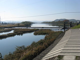
The Kushida River is a major river that flows through central Mie Prefecture on the island of Honshū, Japan. It is officially classified as a Class 1 river by the Japanese government, one of four Class 1 rivers that flow solely through Mie. The majority of river's course is through the city of Matsusaka.

<span class="mw-page-title-main">Komori Dam</span> Dam in Mie, Japan

Komori Dam is a dam in Kumano, Mie Prefecture, Japan. Construction of the dam began in 1963 and was completed in 1965.

<span class="mw-page-title-main">Kuchisubo Dam</span> Dam in Mie Prefecture, Japan

Kuchisubo Dam is a dam in Mie Prefecture, Japan, completed in 1961.

<span class="mw-page-title-main">Misedani Dam</span> Dam in Mie Prefecture, Japan

Misedani Dam is a multipurpose concrete Arch-gravity dam in located in Ōdai, Mie Prefecture, Japan. completed in 1966. The dam is one of several crossing the Miyagawa River, and was intended for hydroelectric power generation, and for the supply of industrial water to the Ise Bay industrial region.

<span class="mw-page-title-main">Nakazato Dam</span> Dam in Mie Prefecture, Japan

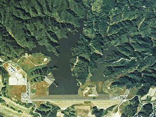
Nakazato Dam is a dam in Mie Prefecture, Japan, completed in 1976.

<span class="mw-page-title-main">Nanairo Dam</span> Dam in Mie Prefecture, Japan

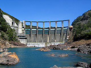
The Nanairo Dam is a concrete gravity-arch dam located in Kumano, Mie Prefecture, Japan. The dam crosses the Kitayama River, a tributary of the Kumano River near the border of Mie Prefecture with Wakayama Prefecture.

<span class="mw-page-title-main">Shorenji Dam</span> Dam in Mie, Japan

Shorenji Dam is a dam in Nabari, Mie Prefecture, Japan, completed in 1970. It is located about 2 miles west of Hinachi Dam, which is actually on a different branch of the Nabari River.

References

  1. 1 2 3 4 5 6 7 8 9 10 11 Geographic Names Server, Wikidata   Q1194038
  2. 1 2 3 4 5 6 Dams in Japan, Japan Dam Foundation, Wikidata   Q113763464