Graphs are unavailable due to technical issues. There is more info on Phabricator and on MediaWiki.org. |
Map of dams in Saitama Prefecture.(See Wikidata query)
The following is a list of dams in Saitama Prefecture, Japan.
Graphs are unavailable due to technical issues. There is more info on Phabricator and on MediaWiki.org. |
The following is a list of dams in Saitama Prefecture, Japan.
| Name | Location | Started | Opened | Height | Length | Image | DiJ number |
|---|---|---|---|---|---|---|---|
| Arima Dam | 35°52′22″N 139°10′38″E | 83.5 m (274 ft) [1] |  | 0640 | |||
| Futase Dam | 35°56′30″N 138°54′35″E | 1961 | 1961 | 95 m (312 ft) [1] |  | 0637 | |
| Kakkaku Dam | 36°3′29″N 138°57′57″E [2] | 1970 | 2001 | 60.9 m (200 ft) [1] |  | 0641 | |
| Maze Dam | 36°9′46″N 139°6′33″E [3] | 27.5 m (90 ft) [1] |  | 0633 | |||
| Shimokubo Dam | 36°7′57″N 139°1′21″E | 1968 | 1968 | 129 m (423 ft) |  | 0615 | |
| Shinsui Dam | 36°9′8″N 139°2′58″E [4] | 20.5 m (67 ft) [1] |  | 0614 | |||
| Suzukawa Sabo Dam | 36°1′30″N 139°15′10″E |  | |||||
| Takizawa Dam | 35°57′21″N 138°53′54″E | 2008 | 2007 | 132 m (433 ft) |  | 0643 | |
| Tamayodo Dam | 36°6′58″N 139°10′10″E | 1962 | 1964 | 32 m (105 ft) |  | 0638 | |
| Tsuburada Dam | 36°7′42″N 139°9′54″E | 1949 | 1954 | 21 m (69 ft) [1] |  | 0635 | |
| Urayama Dam | 35°57′13″N 139°3′8″E | 1998 | 1999 | 156 m (512 ft) | 372 m (1,220 ft) | 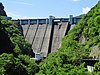 | 0642 |
| Yamaguchi Dam | 35°46′41″N 139°24′55″E | 1999 | 2002 | 33.5 m (110 ft) | 716 m (2,349 ft) |  |
Ibaraki Prefecture is a prefecture of Japan located in the Kantō region of Honshu. Ibaraki Prefecture has a population of 2,828,086 and has a geographic area of 6,097.19 square kilometres. Ibaraki Prefecture borders Fukushima Prefecture to the north, Tochigi Prefecture to the northwest, Saitama Prefecture to the southwest, Chiba Prefecture to the south, and the Pacific Ocean to the east.

Kamikawa is a town located in Saitama Prefecture, Japan. As of 1 February 2021, the town had an estimated population of 13,369 in 5774 households and a population density of 280 persons per km2. The total area of the town is 47.40 square kilometres (18.30 sq mi).

Yorii is a town in Saitama Prefecture, Japan. As of 1 March 2021, the town had an estimated population of 32,851 in 14,689 households and a population density of 510 persons per km². The total area of the town is 64.25 square kilometres (24.81 sq mi).