List of dams in Tottori Prefecture

Last updated

Map of dams in Tottori Prefecture.(See Wikidata query)

The following is a list of dams in Tottori Prefecture, Japan.

Contents

List

NameLocationStartedOpenedHeightLengthImageDiJ number
Asanabe Dam   OOjs UI icon edit-ltr-progressive.svg 35°20′52″N 133°23′42″E [1] 1989200445 m (148 ft)150 m (490 ft) 3046
Ikenotani Tameike Dam   OOjs UI icon edit-ltr-progressive.svg 35°23′25″N 133°46′23″E 192316 m (52 ft)78 m (256 ft) 1669
Kasyo Dam   OOjs UI icon edit-ltr-progressive.svg 35°18′32″N 133°19′46″E [1] 1971198846.4 m (152 ft)174 m (571 ft) Kashou-1685-r1.JPG 1685
Kawagawa No.2 Dam   OOjs UI icon edit-ltr-progressive.svg 35°27′10″N 133°30′50″E 199317 m (56 ft)46 m (151 ft)
Kodamata Dam   OOjs UI icon edit-ltr-progressive.svg 35°26′32″N 133°38′42″E 1977200650 m (160 ft)347 m (1,138 ft) 1689
Matanoagawa Dam   OOjs UI icon edit-ltr-progressive.svg 35°15′44″N 133°29′30″E [1] 1978198469.3 m (227 ft) [2] Matanogawa Dam.jpg 1686
Misasa Dam   OOjs UI icon edit-ltr-progressive.svg 35°23′48″N 133°53′56″E 1956195815 m (49 ft)75.2 m (247 ft) 1679
Mitaki Dam   OOjs UI icon edit-ltr-progressive.svg 35°16′17″N 134°19′59″E [1] 193623.8 m (78 ft)82.5 m (271 ft) Mitaki Dam lake survey 1974.jpg 1673
Momodani Dam   OOjs UI icon edit-ltr-progressive.svg 35°30′38″N 134°16′25″E [1] 1969197318 m (59 ft)79 m (259 ft) 1683
Myogadani Dam   OOjs UI icon edit-ltr-progressive.svg 35°20′51″N 134°27′34″E [1] 1958196040 m (130 ft)124.5 m (408 ft) 1680
Nakatsu Dam   OOjs UI icon edit-ltr-progressive.svg 35°22′32″N 133°59′17″E 1954195735 m (115 ft)96 m (315 ft) 1678
Nishitakao Dam   OOjs UI icon edit-ltr-progressive.svg 35°26′26″N 133°42′7″E [1] 1979199246.2 m (152 ft)237 m (778 ft) Nishitakao Dam.jpg 1690
Ohkamidani Tameike Dam   OOjs UI icon edit-ltr-progressive.svg 35°22′32″N 133°43′31″E 197327.2 m (89 ft)255.5 m (838 ft) Okamidanitameike 1974.jpg 1671
Omiya Dam   OOjs UI icon edit-ltr-progressive.svg 35°13′38″N 133°18′7″E [1] 194016.8 m (55 ft)68.5 m (225 ft) 1674
Sagarikaya Dam   OOjs UI icon edit-ltr-progressive.svg 35°17′36″N 133°33′15″E [1] 2001 [2] 55.5 m (182 ft) [2] 650 m (2,130 ft) [2] 1687
Sajigawa Dam   OOjs UI icon edit-ltr-progressive.svg 35°19′45″N 134°2′36″E [1] 1967197146.5 m (153 ft)105 m (344 ft) 1682
Sakura Tameike Dam   OOjs UI icon edit-ltr-progressive.svg 35°25′51″N 133°42′30″E 197336.6 m (120 ft)115 m (377 ft) 1684
Senjozan Dam   OOjs UI icon edit-ltr-progressive.svg 35°25′41″N 133°36′25″E [1] 1979200343.9 m (144 ft)232.7 m (763 ft) Senjyosan Dam.jpg 1688
Sugesawa Dam  OOjs UI icon edit-ltr-progressive.svg 35°12′19″N 133°18′52″E [1] 73.5 m (241 ft) [2] Sugasawa-1681-r1.JPG 1681
Tetsuzan-ike Dam   OOjs UI icon edit-ltr-progressive.svg 35°26′31″N 133°43′53″E 194019 m (62 ft)78.5 m (258 ft) 1675
Togo Dam   OOjs UI icon edit-ltr-progressive.svg 35°26′41″N 133°55′24″E [1] 1991200339.5 m (130 ft)227 m (745 ft) 3132
Tono Dam  OOjs UI icon edit-ltr-progressive.svg 35°26′57″N 134°20′32″E 1985201175 m (246 ft)294 m (965 ft) Gu idamu - panoramio.jpg 2931
Tsubakidani Tameike Dam   OOjs UI icon edit-ltr-progressive.svg 35°20′7″N 133°18′20″E 189015 m (49 ft)90 m (300 ft) 1663
Yokotani Tameike Dam   OOjs UI icon edit-ltr-progressive.svg 35°23′13″N 133°45′17″E 195216.7 m (55 ft)118.6 m (389 ft) 1677

See also

Related Research Articles

<span class="mw-page-title-main">Tottori Prefecture</span> Prefecture of Japan

Tottori Prefecture is a prefecture of Japan located in the Chūgoku region of Honshu. Tottori Prefecture is the least populous prefecture of Japan at 538,525 (2023) and has a geographic area of 3,507.13 square kilometres (1,354.11 sq mi). Tottori Prefecture borders Shimane Prefecture to the west, Hiroshima Prefecture to the southwest, Okayama Prefecture to the south, and Hyōgo Prefecture to the east.

<span class="mw-page-title-main">Chizu, Tottori</span> Town in Japan

Chizu is a town located in Yazu District, Tottori Prefecture, Japan. As of 1 January 2024, the town had an estimated population of 5,906 in 2681 households and a population density of 26.3 persons per km². The total area of the town is 224.70 square kilometres (86.76 sq mi).

<span class="mw-page-title-main">Nichinan, Tottori</span> Town in Japan

Nichinan is a town located in Hino District, Tottori Prefecture, Japan. As of 31 December 2021, the town had an estimated population of 4,144 in 1903 households and a population density of 12 persons per km2. The total area of the town is 340.962 square kilometres (131.646 sq mi), representing 10% of the total area of Tottori Prefecture.Over 90% of the town is covered by mountains and forest, and 5% of the land is arable. Areas of Nichinan are part of Hiba-Dogo-Taishaku Quasi-National Park.

<span class="mw-page-title-main">Tottori (city)</span> Core city in Chūgoku, Japan

Tottori is the capital and the largest city of Tottori Prefecture in the Chūgoku region of Japan. As of 30 November 2022, the city had an estimated population of 183,383 in 81,732 households and a population density of 240 persons per km². The total area of the city is 765.31 square kilometres (295.49 sq mi). Most of the city is within the San'in Kaigan Geopark.

<span class="mw-page-title-main">Hino River</span> River in Japan

The Hino River is a major river in the western part of Tottori Prefecture. The river flows east-northeast for 77 kilometres (48 mi), and is the longest river in the prefecture. The Hino River emerges from the Chūgoku Mountains. The source of the river is at an elevation of 1,004 metres (3,294 ft) in an area near Mount Mikuni and Mount Dōgo in Nichinan in southeastern Tottori Prefecture. At Kofu, the river turns north-northwest. The lower part of the Hino River flows through the Yonago Plain before finally discharging into Miho Bay at Hiezu near Yonago. Erosion over time has created the scenic Sekkakei Ravine. The Sukesawa Dam forms an artificial lake, Lake Nichinan. Approximately 60,800 people use the water provided by the Hino River.

<span class="mw-page-title-main">Japan National Route 29</span> National highway in Japan

National Route 29 is a national highway connecting Himeji and Tottori in Japan.

<span class="mw-page-title-main">Sendai River</span> River in Tottori Prefecture, Japan

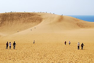
The Sendai River is a river in eastern Tottori Prefecture, Japan. The Sendai is 52 kilometers (32 mi) in length and has a drainage area of 1,190 square kilometers (460 sq mi). The source of the river is in the Chūgoku Mountains. The Sendai flows north through Tottori Prefecture into the Sea of Japan. Under the Rivers Act of 1964 it is designated a Class 1 River, and is managed by the Japanese Ministry of Land, Infrastructure, Transport and Tourism. About 200,000 people live along the course of the river. The Sendai River provides sediment to form the Tottori Sand Dunes, the largest dune system in Japan.

References

  1. 1 2 3 4 5 6 7 8 9 10 11 12 13 Geographic Names Server, Wikidata   Q1194038
  2. 1 2 3 4 5 Dams in Japan, Japan Dam Foundation, Wikidata   Q113763464