Graphs are unavailable due to technical issues. There is more info on Phabricator and on MediaWiki.org. |
Map of dams in Wakayama Prefecture.(See Wikidata query)
The following is a list of dams in Wakayama Prefecture, Japan.
Graphs are unavailable due to technical issues. There is more info on Phabricator and on MediaWiki.org. |
The following is a list of dams in Wakayama Prefecture, Japan.
| Name | Location | Started | Opened | Height | Length | Image | DiJ number |
|---|---|---|---|---|---|---|---|
| Futagawa Dam | 34°4′50″N 135°21′32″E | 67.4 m (221 ft) [1] |  | 1647 | |||
| Hirogawa Dam | 33°58′26″N 135°14′0″E | 53.5 m (176 ft) [1] |  | 1648 | |||
| Kirimegawa Dam | 33°52′52″N 135°19′15″E | 1991 | 2014 | 44.5 m (146 ft) | 3131 | ||
| Kodakumi Dam | 33°35′38″N 135°50′4″E [2] | 35.9 m (118 ft) [1] |  | 1646 | |||
| Komori Dam | 33°56′5″N 135°55′41″E [2] | 34 m (112 ft) [1] |  | 1313 | |||
| Nanairo Dam | 33°57′37″N 136°0′9″E [2] | 1965 | 61 m (200 ft) [1] |  | 1312 | ||
| Shichikawa Dam | 33°35′52″N 135°41′43″E |  | |||||
| Tonoyama Dam | 33°41′2″N 135°33′49″E [2] | 64.5 m (212 ft) [1] |  | 1644 | |||
| Torinose Dam | 33°50′38″N 135°22′26″E [2] | ||||||
| Tsubayama Dam | 33°57′32″N 135°23′27″E [2] | 1966 | 1988 | 56.5 m (185 ft) [1] |  | 1649 | |
| Yamada Dam | 34°11′37″N 135°20′2″E | 1950 | 1957 [3] | 34 m (112 ft) |  | 1645 |

Wakayama Prefecture is a prefecture of Japan located in the Kansai region of Honshu. Wakayama Prefecture has a population of 944,320 and has a geographic area of 4,724 square kilometres (1,824 sq mi). Wakayama Prefecture borders Osaka Prefecture to the north, and Mie Prefecture and Nara Prefecture to the northeast.

Tokushima Prefecture is a prefecture of Japan located on the island of Shikoku. Tokushima Prefecture has a population of 728,633 and has a geographic area of 4,146 km2. Tokushima Prefecture borders Kagawa Prefecture to the north, Ehime Prefecture to the west, and Kōchi Prefecture to the southwest.

Wakayama is the capital city of Wakayama Prefecture in the Kansai region of Japan. As of 1 December 2021, the city had an estimated population of 351,391 in 157066 households and a population density of 1700 persons per km². The total area of the city is 208.84 square kilometres (80.63 sq mi).
Aridagawa is a town located in Arida District, in central Wakayama Prefecture, Japan. As of 30 November 2021, the town had an estimated population of 25,940 in 10680 households and a population density of 74 persons per km². The total area of the town is 351.84 square kilometres (135.85 sq mi).

National Route 42, also called Kumano Kaidō or Tropical Route is a national highway connecting Hamamatsu, Shizuoka and Wakayama, Wakayama in Japan. Part of the route requires crossing Ise Bay on the Ise-wan Ferry.
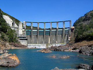
The Nanairo Dam is a concrete gravity-arch dam located in Kumano, Mie Prefecture, Japan. The dam crosses the Kitayama River, a tributary of the Kumano River near the border of Mie Prefecture with Wakayama Prefecture.
Wakayama Dam(Japanese: 若山ダム) is an earthfill dam located in Ishikawa Prefecture in Japan. The dam is used for irrigation. The catchment area of the dam is 4.2 km2. The dam impounds about 6 ha of land when full and can store 486 thousand cubic meters of water. The construction of the dam was completed in 1963.