List of dams in Kumamoto Prefecture

Last updated

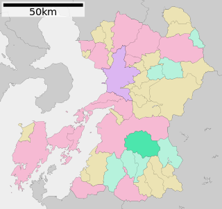
Map of dams in Kumamoto Prefecture.(See Wikidata query)

The following is a list of dams in Kumamoto Prefecture, Japan.

Contents

List

NameLocationOpenedHeight (metres)Image
Aburatani Dam   OOjs UI icon edit-ltr-progressive.svg 32°25′15″N 130°41′43″E 197582 Aburatani-2672-r1.JPG
Akagi Dam  OOjs UI icon edit-ltr-progressive.svg 32°19′27″N 130°6′23″E [1]
Amagimi Dam   OOjs UI icon edit-ltr-progressive.svg 32°44′21″N 130°50′29″E [1] 197039
Arase Dam  OOjs UI icon edit-ltr-progressive.svg 32°25′25″N 130°38′47″E Arasedam-0A3N80pbxFs6g.JPG
Fukasako Dam   OOjs UI icon edit-ltr-progressive.svg 32°49′41″N 130°50′37″E [1] 19 CKU20082-C23-36 Fukasako Dam.jpg
Funatsu Dam   OOjs UI icon edit-ltr-progressive.svg 32°37′53″N 130°53′35″E [1] 25.5
Hikawa Dam   OOjs UI icon edit-ltr-progressive.svg 32°34′16″N 130°47′12″E [1] 58.5 Hikawa-3139-r1.JPG
Himenokawauchi Dam   OOjs UI icon edit-ltr-progressive.svg 32°15′15″N 130°1′44″E [1] 198721
Ichifusa Dam   OOjs UI icon edit-ltr-progressive.svg 32°19′13″N 131°0′46″E [1] 195978.5 Ichifusa Dam.jpg
Ishiuchi Dam   OOjs UI icon edit-ltr-progressive.svg 32°38′37″N 130°31′10″E [1] 199238.5 040125ishiuchidam2.jpg
Itsuwa Dam   OOjs UI icon edit-ltr-progressive.svg 32°29′1″N 130°7′30″E [1] 198537.1
Itsuwatobu Dam   OOjs UI icon edit-ltr-progressive.svg 32°28′58″N 130°8′44″E [1] 200233.3
Kamekawa Dam   OOjs UI icon edit-ltr-progressive.svg 32°25′55″N 130°8′6″E [1] 198237
Kawabe Dam  OOjs UI icon edit-ltr-progressive.svg 32°20′14″N 130°50′28″E 107.5 [2] Kawabegawa-2677-r1.JPG
Kono Dam   OOjs UI icon edit-ltr-progressive.svg 32°18′23″N 131°0′10″E 195921.2 Kouno-2662-r1.JPG
Kotsuura Dam   OOjs UI icon edit-ltr-progressive.svg 32°28′37″N 130°19′29″E 200454
Kusuura Dam   OOjs UI icon edit-ltr-progressive.svg 32°24′12″N 130°10′22″E [1] 196632
Kuwanouchi Dam   OOjs UI icon edit-ltr-progressive.svg 32°43′49″N 131°12′22″E [1] 195526.5
Kyoragi Dam   OOjs UI icon edit-ltr-progressive.svg 32°27′34″N 130°22′13″E [1] 197629.3
Midorikawa Dam   OOjs UI icon edit-ltr-progressive.svg 32°37′38″N 130°54′33″E [1] 197076.5
Midorikawa Hojo Dam   OOjs UI icon edit-ltr-progressive.svg 32°37′47″N 130°54′23″E 197035
Nishigochi Dam   OOjs UI icon edit-ltr-progressive.svg 32°25′19″N 130°23′19″E 197017.5
Yairagi No.2 Dam   OOjs UI icon edit-ltr-progressive.svg 32°14′45″N 130°2′0″E [1] 198436.1
Ohkiribata Dam   OOjs UI icon edit-ltr-progressive.svg 32°50′29″N 130°55′52″E 197523
Ohkubo Tameike Dam   OOjs UI icon edit-ltr-progressive.svg 32°13′3″N 130°40′8″E 191415
Oso Dam   OOjs UI icon edit-ltr-progressive.svg 32°59′44″N 131°12′4″E [1] 201969.9 damuWan Cheng Hou moShui gatamaranaiDa Su damu(A Su Chan Shan Cun )2012Nian 3Yue 25Ri .JPG
Otani Dam   OOjs UI icon edit-ltr-progressive.svg 32°51′21″N 131°15′42″E [1] 194026.1 Otani Dam (Takamori, Kumamoto) survey 1976.jpg
Rogi Dam   OOjs UI icon edit-ltr-progressive.svg 32°16′55″N 130°5′13″E 201353
Ryumon Dam  OOjs UI icon edit-ltr-progressive.svg 33°2′13″N 130°50′57″E [1] 99.5 [2] Ryumon-2675-r1.JPG
Seiganji Dam   OOjs UI icon edit-ltr-progressive.svg 32°11′52″N 130°56′19″E [1] 197860.5 CKU768-C9-29 Seiganji Dam.jpg
Setoishi Dam   OOjs UI icon edit-ltr-progressive.svg 32°21′31″N 130°38′26″E [1] 195826.5 Setoishi Dam.JPG
Shiibaru Dam  OOjs UI icon edit-ltr-progressive.svg 32°29′5″N 130°53′37″E [1]
Shiki Dam   OOjs UI icon edit-ltr-progressive.svg 32°29′3″N 130°4′10″E [1] 197336
Shimouke Dam   OOjs UI icon edit-ltr-progressive.svg 33°9′36″N 130°59′4″E [1] Shimouke-2797-r1.JPG
Shiraishizeki Dam  OOjs UI icon edit-ltr-progressive.svg 32°58′10″N 130°35′43″E [1]
Tateno Dam   OOjs UI icon edit-ltr-progressive.svg 32°52′32″N 130°58′20″E 90 Li Ye damu03.jpg
Tororo Dam  OOjs UI icon edit-ltr-progressive.svg 32°27′42″N 130°3′41″E [1] 41.8 [2]
Tsukaze Dam  OOjs UI icon edit-ltr-progressive.svg 32°38′30″N 130°51′54″E [1]
Uchidani Dam   OOjs UI icon edit-ltr-progressive.svg 32°25′20″N 130°43′54″E [1] 197564

See also

Related Research Articles

<span class="mw-page-title-main">Kumamoto Prefecture</span> Prefecture of Japan

Kumamoto Prefecture is a prefecture of Japan located on the island of Kyūshū. Kumamoto Prefecture has a population of 1,748,134 and has a geographic area of 7,409 square kilometres (2,861 sq mi). Kumamoto Prefecture borders Fukuoka Prefecture to the north, Ōita Prefecture to the northeast, Miyazaki Prefecture to the southeast, and Kagoshima Prefecture to the south.

<span class="mw-page-title-main">Ōno River</span> River in Ōita, Japan

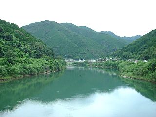
The Ōno River is a river that originates in Ōita Prefecture, Japan. After running through the southern and central portions of Ōita Prefecture, it runs through the eastern part of Kumamoto Prefecture and the northern part of Miyazaki Prefecture.

<span class="mw-page-title-main">Itsuki, Kumamoto</span> Village in Kyushu, Japan

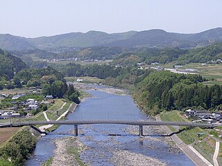
Itsuki is a village located in Kuma District, Kumamoto Prefecture, Japan.

<span class="mw-page-title-main">Kuma River (Japan)</span> River in Kumamoto Prefecture, Kyūshū, Japan

The Kuma River is a river in Kumamoto Prefecture, central Western part of Kyūshū, Japan. It is sometimes referred as Kumagawa River. It is the longest river in Kyushu, with the length of 115 km long and has a drainage area of 1,880 km2 (730 sq mi). The tidal flat of the Kuma River estuary is approximately 1000 hectares.

<span class="mw-page-title-main">1953 Northern Kyushu flood</span>

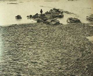
The 1953 North Kyushu flood was a flood which hit Northern Kyushu, Japan in June 1953. The flood was caused by cloudbursts and prolonged rain from the Meiyu rain front which dropped 1,000 mm of rain over Mount Aso and Mount Hiko. This downpour resulted in the overflow of many of the surrounding rivers, such as the Chikugo River.

<span class="mw-page-title-main">2016 Kumamoto earthquakes</span> Earthquake in Japan

The 2016 Kumamoto earthquakes were a series of earthquakes, including a magnitude 7.0 mainshock which struck at 01:25 JST on April 16, 2016 beneath Kumamoto City of Kumamoto Prefecture in Kyushu Region, Japan, at a depth of about 10 kilometres (6.2 mi), and a foreshock earthquake with a magnitude 6.2 at 21:26 JST (12:26 UTC) on April 14, 2016, at a depth of about 11 kilometres (6.8 mi).

References

  1. 1 2 3 4 5 6 7 8 9 10 11 12 13 14 15 16 17 18 19 20 21 22 23 24 25 26 27 28 Geographic Names Server, Wikidata   Q1194038
  2. 1 2 3 Dams in Japan, Japan Dam Foundation, Wikidata   Q113763464