List of dams in Fukushima Prefecture

Last updated

Map of dams in Fukushima Prefecture(See Wikidata query)

The following is a list of dams in Fukushima Prefecture, Japan.

Contents

List

NameLocationOpenedHeight (metres)Image
Akasaka Dam  OOjs UI icon edit-ltr-progressive.svg 37°8′53″N 140°6′28″E [1] 18.3 [2]
Akimotoko Dam   OOjs UI icon edit-ltr-progressive.svg 37°39′10″N 140°6′45″E 199910.6 Akimotoko-s-r1.jpg
Asahi Dam   OOjs UI icon edit-ltr-progressive.svg 37°15′16″N 139°52′5″E 16.1 [2] Asahi-r1.jpg
Dake Dam  OOjs UI icon edit-ltr-progressive.svg 37°36′26″N 140°21′41″E 60 [2]
Fujikura Dam  OOjs UI icon edit-ltr-progressive.svg 37°51′41″N 140°28′22″E [1] 36.5 [2] CTO201120-C1-15 Fujikura Dam (Fukushima).jpg
Fujinuma Dam   OOjs UI icon edit-ltr-progressive.svg 37°18′7″N 140°11′41″E 1949 Reservoir Fujinuma 20090321.Jpg
Fukada Dam  OOjs UI icon edit-ltr-progressive.svg 37°23′1″N 140°15′23″E 55.5 [2] 20080524FukadaDam.JPG
Futamata Dam  OOjs UI icon edit-ltr-progressive.svg 37°29′14″N 139°46′39″E [1] 30 [2]
Hatori Dam   OOjs UI icon edit-ltr-progressive.svg 37°16′18″N 140°4′34″E [1] 195637.1 Hatori-490-r1.jpg
Higashiyama Dam  OOjs UI icon edit-ltr-progressive.svg 37°27′38″N 139°57′56″E [1] 70 [2]
Honna Dam   OOjs UI icon edit-ltr-progressive.svg 37°26′29″N 139°29′35″E [1] 195451.5 [2] Honna-488-r1.jpg
Horai Dam  OOjs UI icon edit-ltr-progressive.svg 37°38′41″N 140°31′41″E [1] [3] 21.5 [2] Horai Dam right view.jpg
Horikawa Dam  OOjs UI icon edit-ltr-progressive.svg 37°9′14″N 140°4′14″E [1] 20081105Ku Chuan damu.JPG
Iritono Dam  OOjs UI icon edit-ltr-progressive.svg 37°3′54″N 140°39′51″E [1]
Iwabe Dam  OOjs UI icon edit-ltr-progressive.svg 37°38′45″N 140°41′12″E [1]
Jurokkyo Dam   OOjs UI icon edit-ltr-progressive.svg 37°31′18″N 140°1′28″E Jyurokkyou-s-r1.jpg
Kaminojiri Dam   OOjs UI icon edit-ltr-progressive.svg 37°37′55″N 139°37′52″E 195830 Kaminojiri-495-r1.jpg
Katakado Dam   OOjs UI icon edit-ltr-progressive.svg 37°33′52″N 139°45′45″E 195329 [2] Katakado-485-r1.jpg
Kodama Dam  OOjs UI icon edit-ltr-progressive.svg 37°7′25″N 140°49′39″E [1] 102 [2] Kodamagawa II Dam left view.jpg
Komachi Dam  OOjs UI icon edit-ltr-progressive.svg 37°16′47″N 140°35′11″E [1] 37 [2]
Konosu Dam  OOjs UI icon edit-ltr-progressive.svg 37°51′3″N 140°53′35″E [1] 23.5 [2]
Kuromori Dam  OOjs UI icon edit-ltr-progressive.svg 37°7′38″N 140°4′28″E [1] 20.2 [2] 20100719Hei Sen damu.jpg
Mano Dam  OOjs UI icon edit-ltr-progressive.svg 37°43′7″N 140°49′59″E [1] 69 [2]
Matsugabo Dam  OOjs UI icon edit-ltr-progressive.svg 37°47′51″N 140°46′20″E [1] 46 [2] CTO201311-C36-3 Matsugabo Dam.jpg
Miharu Dam   OOjs UI icon edit-ltr-progressive.svg 37°24′14″N 140°28′30″E [1] 199765 Miharu-525-r1.jpg
Miyakawa Dam   OOjs UI icon edit-ltr-progressive.svg 37°22′33″N 139°47′16″E [1] 42 [2] Miyagawa-504-r1.jpg
Miyashita Dam   OOjs UI icon edit-ltr-progressive.svg 37°27′46″N 139°37′46″E [1] 194653 [2] Miyashita-481-r1.jpg
Modo Dam  OOjs UI icon edit-ltr-progressive.svg 37°21′49″N 140°52′25″E [1] 22 [2]
Nishigo Dam  OOjs UI icon edit-ltr-progressive.svg 37°11′5″N 140°4′44″E [1] 32.5 [2]
Nitchu Dam  OOjs UI icon edit-ltr-progressive.svg 37°45′8″N 139°54′30″E [1] Hotspring Nicchuu Fukushima 02.jpg
Notekami Dam  OOjs UI icon edit-ltr-progressive.svg 37°38′7″N 140°48′11″E [1]
Ogaki Dam  OOjs UI icon edit-ltr-progressive.svg 37°30′53″N 140°53′4″E [1]
Ogi Dam  OOjs UI icon edit-ltr-progressive.svg 37°20′42″N 140°54′19″E [1] 27.8 [2]
Okawa Dam   OOjs UI icon edit-ltr-progressive.svg 37°20′51″N 139°54′37″E [1] 1988 Okawa-523-r1.jpg
Okusagawa Dam  OOjs UI icon edit-ltr-progressive.svg 37°2′3″N 140°24′45″E [1]
Okutadami Dam   OOjs UI icon edit-ltr-progressive.svg 37°9′13″N 139°14′59″E [1] 1961157 [2] Okutadami Dam 001.jpg
Otori Dam   OOjs UI icon edit-ltr-progressive.svg 37°12′55″N 139°12′49″E [1] 196383 [2] Otori Dam survey 1976.jpg
Otsumata Dam  OOjs UI icon edit-ltr-progressive.svg 37°2′53″N 139°17′54″E [1] 52 [2] Otsumata Dam lake survey 1976.jpg
Ouchi Dam   OOjs UI icon edit-ltr-progressive.svg 37°20′35″N 139°52′17″E [1] 1991102 Shimogo Ouchi Dam.jpg
Ozaso Dam  OOjs UI icon edit-ltr-progressive.svg 37°48′23″N 140°23′14″E [1] 27.2 [2] CTO20071-C14-9 Ozaso Dam.jpg
Ryui Dam  OOjs UI icon edit-ltr-progressive.svg 37°17′10″N 140°8′15″E [1] 32.5 [2] 20080524RyuseiDam.JPG
Sakashita Dam  OOjs UI icon edit-ltr-progressive.svg 37°22′59″N 140°56′39″E [1] 43 [2] Sakashita Dam 04.jpg
Sekishiba Dam  OOjs UI icon edit-ltr-progressive.svg 37°40′56″N 139°55′36″E [1] 20 [2]
Sengosawa Dam  OOjs UI icon edit-ltr-progressive.svg 37°11′15″N 140°29′7″E [1] SengozawaDam1.JPG
Shingo Dam   OOjs UI icon edit-ltr-progressive.svg 37°36′41″N 139°44′11″E 27.5 [2] Shhingo-475-r1.jpg
Shin-Miyakawa Dam   OOjs UI icon edit-ltr-progressive.svg 37°21′50″N 139°46′52″E [1] 69 [2] Xin Gong Chuan damu.jpg
Shinobu Dam  OOjs UI icon edit-ltr-progressive.svg 37°42′58″N 140°29′52″E [1] 21.5 [2] Shinobu Dam.jpg
Shitoki Dam  OOjs UI icon edit-ltr-progressive.svg 36°54′21″N 140°43′6″E [1] 83.5 [2] Shitoki Dam 10.jpg
Surikamigawa Dam   OOjs UI icon edit-ltr-progressive.svg 37°55′35″N 140°24′57″E [1] 105 [2] Surigamigawa-536-r1.jpg
Tadami Dam   OOjs UI icon edit-ltr-progressive.svg 37°20′8″N 139°18′4″E 198930 [2] Tadami-541-r1.JPG
Tajima Dam  OOjs UI icon edit-ltr-progressive.svg 37°14′1″N 139°44′22″E [1] 36 [2]
Takashiba Dam  OOjs UI icon edit-ltr-progressive.svg 36°57′24″N 140°43′58″E [1] 59.5 [2] Takashiba Dam.jpg
Taki Dam   OOjs UI icon edit-ltr-progressive.svg 37°23′13″N 139°23′3″E [1] 196146 [2] Taki-499-r1.JPG
Tagokura Dam   OOjs UI icon edit-ltr-progressive.svg 37°18′38″N 139°17′13″E 1959145 [2] Tagokura-494-r1.JPG
Takanokura Dam  OOjs UI icon edit-ltr-progressive.svg 37°37′49″N 140°53′29″E [1] 54.2 [2] Takanokura Dam 05.jpg
Tetsuzan Dam  OOjs UI icon edit-ltr-progressive.svg 37°34′22″N 140°52′51″E [1] 25.2 [2] Tetsuzan Dam 03.jpg
Tochizawa Dam  OOjs UI icon edit-ltr-progressive.svg 37°23′42″N 139°52′20″E [1] 23.7 [2]
Uwada Dam   OOjs UI icon edit-ltr-progressive.svg 37°28′58″N 139°32′16″E [1] 195434 [2] Uwada-487-r1.jpg
Yamanoiri Dam  OOjs UI icon edit-ltr-progressive.svg 37°37′50″N 140°25′10″E [1] 29.5 [2]
Yamasato Dam   OOjs UI icon edit-ltr-progressive.svg 37°36′23″N 139°41′15″E 22.5 [2] Yamasato-478-r1.jpg
Yanaizu Dam   OOjs UI icon edit-ltr-progressive.svg 37°31′8″N 139°42′25″E 195334 [2] Yanaizu-486-r1.jpg
Yokokawa Dam  OOjs UI icon edit-ltr-progressive.svg 37°35′57″N 140°54′20″E [1] 78.5 [2] Yokokawa Dam (Fukushima) 01.jpg
Yoshigadaira Dam  OOjs UI icon edit-ltr-progressive.svg 37°26′50″N 140°0′21″E [1] 22.5 [2]

See also

Related Research Articles

<span class="mw-page-title-main">Fukushima (city)</span> Core city in Tōhoku, Japan

Fukushima is the capital city of Fukushima Prefecture, Japan. It is located in the northern part of the Nakadōri, central region of the prefecture. As of 1 August 2023, the city had an estimated population of 275,850 in 122,130 households and a population density of 359 inhabitants per square kilometre (930/sq mi). The total area of the city is 767.72 square kilometres (296.42 sq mi).

<span class="mw-page-title-main">Fukushima Prefecture</span> Prefecture of Japan

Fukushima Prefecture is a prefecture of Japan located in the Tōhoku region of Honshu. Fukushima Prefecture has a population of 1,771,100 and has a geographic area of 13,783.90 square kilometres (5,321.99 sq mi). Fukushima Prefecture borders Miyagi Prefecture and Yamagata Prefecture to the north, Niigata Prefecture to the west, Gunma Prefecture to the southwest, and Tochigi Prefecture and Ibaraki Prefecture to the south.

<span class="mw-page-title-main">Sukagawa, Fukushima</span> City in Tōhoku, Japan

Sukagawa is a city located in Fukushima Prefecture, Japan. As of 1 May 2018, the city had an estimated population of 76,251 in 38824 households, and a population density of 270 persons per km2. The total area of the city was 279.43 square kilometres (107.9 sq mi).

<span class="mw-page-title-main">Shimogō, Fukushima</span> Town in Tōhoku, Japan

Shimogō is a town located in Fukushima Prefecture, Japan. As of 1 April 2020, the town had an estimated population of 5,517 in 2216 households and a population density of 17 persons per km2. The total area of the town was 317.04 square kilometres (122.41 sq mi).

<span class="mw-page-title-main">Hinoemata, Fukushima</span> Village in Tōhoku, Japan

Hinoemata is a village located in Fukushima Prefecture, Japan. As of 1 January 2020, the village had an estimated population of 556, and a population density of 1.5 persons per km². The total area of the village was 390.46 square kilometres (150.76 sq mi). It is locally famous for its soba and known nationally for its kabuki performances and as a gateway to the Oze marshlands.

<span class="mw-page-title-main">Tadami, Fukushima</span> Town in Tōhoku, Japan

Tadami is a town located in Fukushima Prefecture, Japan. As of 1 March 2020, the town has an estimated population of 4,117 in 1749 households, of which 45.88% were classified as "elderly households" The town had a population density of 5.5 persons per km2. The total area of the town was 747.56 square kilometres (288.63 sq mi). Tadami is famous locally for its own Snow Festival, where huge sculptures and replicas of monuments are cut out of Tadami's abundant snow.

<span class="mw-page-title-main">Mishima, Fukushima</span> Town in Tōhoku, Japan

Mishima is a town located in Fukushima Prefecture, Japan. As of 1 March 2020, the town had an estimated population of 1,590 in 755 households, and a population density of 18 persons per square kilometre. The total area of the town was 90.81 square kilometres (35.06 sq mi). In 2017, Mishima was selected as one of The Most Beautiful Villages in Japan.

<span class="mw-page-title-main">Nishigō, Fukushima</span> Village in Tōhoku, Japan

Nishigō is a village located in Fukushima Prefecture, Japan. As of 1 March 2020, the village had an estimated population of 20,351 in 7618 households and a population density of 110 persons per km2. The total area of the village was 192.06 square kilometres (74.15 sq mi)..

<span class="mw-page-title-main">Tone River</span> River in Kantō, Japan

The Tone River is a river in the Kantō region of Japan. It is 322 kilometers (200 mi) in length and has a drainage area of 16,840 square kilometers (6,500 sq mi). It is nicknamed Bandō Tarō ; Bandō is an obsolete alias of the Kantō Region, and Tarō is a popular given name for an oldest son. It is regarded as one of the "Three Greatest Rivers" of Japan, the others being the Yoshino in Shikoku and the Chikugo in Kyūshū.

<span class="mw-page-title-main">Asahi Dam (Fukushima)</span> Dam in Fukushima, Japan

Asahi Dam (旭ダム) is a dam in Shimogō, Fukushima Prefecture, Japan, completed in 1935.

<span class="mw-page-title-main">Hatori Dam</span> Dam in Fukushima, Japan

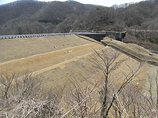
Hatori Dam is a dam in Ten'ei, Fukushima Prefecture, Japan. Hatori Dam is managed directly by the Ministry of Agriculture, Forestry and Fisheries, and is intended to provide irrigation for the Shirakawa area of the Abukuma River Basin. The dam is an earth dam with a height of 37.1 meters. The reservoir created by the dam is called Lake Hatori, and has been developed as a resort area.

<span class="mw-page-title-main">Yamasato Dam</span> Dam in Fukushima Prefecture, Japan.

Yamasato Dam is a dam in the Fukushima Prefecture of Japan, completed in 1943.

References

  1. 1 2 3 4 5 6 7 8 9 10 11 12 13 14 15 16 17 18 19 20 21 22 23 24 25 26 27 28 29 30 31 32 33 34 35 36 37 38 39 40 41 42 43 44 45 46 47 48 49 50 Geographic Names Server, Wikidata   Q1194038
  2. 1 2 3 4 5 6 7 8 9 10 11 12 13 14 15 16 17 18 19 20 21 22 23 24 25 26 27 28 29 30 31 32 33 34 35 36 37 38 39 40 41 42 43 44 45 46 47 Dams in Japan, Japan Dam Foundation, Wikidata   Q113763464
  3. http://damnet.or.jp/cgi-bin/binranA/enAll.cgi?db4=0473