List of dams in Iwate Prefecture

Last updated

Map of dams in Iwate Prefecture.(See Wikidata query)

The following is a list of dams in Iwate Prefecture, Japan.

Contents

List

NameLocationOpenedHeight (metres)Image
Akazawa Dam  OOjs UI icon edit-ltr-progressive.svg 39°29′55″N 140°46′15″E [1]
Appi Bosai Dam  OOjs UI icon edit-ltr-progressive.svg 40°0′53″N 140°56′3″E [1]
Arasawa No. 1 Dam   OOjs UI icon edit-ltr-progressive.svg 40°0′53″N 140°56′3″E 197238
Arasawa No.2 Dam   OOjs UI icon edit-ltr-progressive.svg 40°2′5″N 140°56′41″E [1] 198945.5
Arasawa No.3 Dam   OOjs UI icon edit-ltr-progressive.svg 40°2′40″N 140°57′32″E [1] 196022
Fudai Dam   OOjs UI icon edit-ltr-progressive.svg 39°59′50″N 141°54′10″E [1] 37.3
Gando Dam   OOjs UI icon edit-ltr-progressive.svg 39°49′37″N 141°22′24″E 196040 Gandou-242-r1.jpg
Gosho Dam   OOjs UI icon edit-ltr-progressive.svg 39°41′37″N 141°1′48″E 198152.5 Gosho-256-r1.JPG
Hayachine Dam   OOjs UI icon edit-ltr-progressive.svg 39°31′54″N 141°20′22″E 200073.5 Hayachine Dam.JPG
Hinata Dam   OOjs UI icon edit-ltr-progressive.svg 39°17′35″N 141°47′51″E [1] 56.5 HinataDam1.JPG
Hisanai Tameike Dam   OOjs UI icon edit-ltr-progressive.svg 39°18′6″N 141°39′38″E 198227
Ikatai Dam   OOjs UI icon edit-ltr-progressive.svg 40°0′52″N 141°7′59″E [1] 40
Irihata Dam   OOjs UI icon edit-ltr-progressive.svg 39°14′22″N 140°56′59″E [1] 199080 Irihata-259-r1.JPG
Isawa Dam   OOjs UI icon edit-ltr-progressive.svg 39°7′17″N 140°44′11″E 2013 Isawa dam 1.jpg
Ishibane Dam   OOjs UI icon edit-ltr-progressive.svg 39°18′18″N 140°57′14″E [1] 195320.5 Ishibane-237-r1.JPG
Ishibuchi Dam   OOjs UI icon edit-ltr-progressive.svg 39°6′48″N 140°54′13″E 1953 Ishibuchi-235-r1.jpg
Iwasaki Nojo Tameike Dam   OOjs UI icon edit-ltr-progressive.svg 39°15′40″N 140°59′14″E 193824.2
Kanagoezawa Dam   OOjs UI icon edit-ltr-progressive.svg 38°50′36″N 141°23′37″E [1] 200543
Kemuyama Dam   OOjs UI icon edit-ltr-progressive.svg 39°36′58″N 141°5′56″E [1] 21.8 Kemuyama Dam lake 1976.jpg
Koromogawa No.1 Dam   OOjs UI icon edit-ltr-progressive.svg 39°6′0″N 140°57′58″E [1] 196335.5
Koromogawa No.2 Dam   OOjs UI icon edit-ltr-progressive.svg 39°0′14″N 141°0′46″E 197134
Koromogawa No.3 Dam   OOjs UI icon edit-ltr-progressive.svg 39°1′23″N 141°2′1″E [1] 41
Koromogawa No.4 Dam   OOjs UI icon edit-ltr-progressive.svg 39°3′43″N 141°0′13″E [1] 33
Koromogawa No.5 Dam   OOjs UI icon edit-ltr-progressive.svg 39°0′34″N 141°3′48″E [1] 20.5
Kuzumaru Dam   OOjs UI icon edit-ltr-progressive.svg 39°30′45″N 141°3′11″E 199151.7 Kuzumaru dam.jpg
Neishi Dam   OOjs UI icon edit-ltr-progressive.svg 40°11′6″N 140°57′55″E [1] 41
Ono Dam   OOjs UI icon edit-ltr-progressive.svg 40°14′53″N 141°38′57″E [1] 26
Ohsawa Dam   OOjs UI icon edit-ltr-progressive.svg 39°35′13″N 141°44′38″E 194330.8
Oshida Dam   OOjs UI icon edit-ltr-progressive.svg 40°5′21″N 141°17′44″E [1] 63.7
Oshuku Dam   OOjs UI icon edit-ltr-progressive.svg 39°36′50″N 140°53′37″E [1] 17.5
Rentaki Dam   OOjs UI icon edit-ltr-progressive.svg 39°34′10″N 140°54′46″E [1] 37.7
Ryorigawa Dam   OOjs UI icon edit-ltr-progressive.svg 39°3′44″N 141°46′42″E 200043
Sannokai Dam   OOjs UI icon edit-ltr-progressive.svg 39°32′51″N 141°3′53″E 200161.5 Sannoukai-263-r1.JPG
Senganishi Dam   OOjs UI icon edit-ltr-progressive.svg 39°13′29″N 141°0′31″E 193431.3
Senmatsu Dam   OOjs UI icon edit-ltr-progressive.svg 38°48′3″N 141°24′48″E [1] 26.8
Setsukinai Dam   OOjs UI icon edit-ltr-progressive.svg 40°6′51″N 141°29′36″E [1] 38.5
Shijushida Dam   OOjs UI icon edit-ltr-progressive.svg 39°45′10″N 141°8′54″E 196850 Shijyushida-249-r1.JPG
Sorihikizawa Tameike Dam   OOjs UI icon edit-ltr-progressive.svg 39°12′51″N 141°0′36″E 193523.5
Sotomasuzawa Dam   OOjs UI icon edit-ltr-progressive.svg 39°36′49″N 140°58′12″E [1] 22.5
Sotoyama Dam   OOjs UI icon edit-ltr-progressive.svg 39°46′32″N 141°17′1″E [1] 33
Taki Dam   OOjs UI icon edit-ltr-progressive.svg 40°9′5″N 141°43′24″E [1] 70 CTO20112-C18-3 Taki Dam (Iwate).jpg
Takou Dam   OOjs UI icon edit-ltr-progressive.svg 39°9′20″N 141°42′7″E 200677 Ying Sheng damu007.JPG
Tase Dam   OOjs UI icon edit-ltr-progressive.svg 39°20′35″N 141°19′7″E [1] 195481.5 Tase-238-r1.JPG
Tokitosawa Tameike Dam   OOjs UI icon edit-ltr-progressive.svg 39°20′24″N 140°57′52″E 198816
Tono Dam   OOjs UI icon edit-ltr-progressive.svg 39°18′22″N 141°32′7″E [1] 195726.5
Tono No.2 Dam   OOjs UI icon edit-ltr-progressive.svg 39°19′7″N 141°31′47″E 201023.1
Toyosawa Dam   OOjs UI icon edit-ltr-progressive.svg 39°28′50″N 140°58′27″E [1] 196159.1 Toyosawa-245-r1.JPG
Tsunatori Dam   OOjs UI icon edit-ltr-progressive.svg 39°42′40″N 141°12′18″E [1] 198259 Tsunatori Dam.JPG
Yabitsu Dam   OOjs UI icon edit-ltr-progressive.svg 39°36′56″N 141°0′35″E [1] 198133.5
Yanagawa Dam   OOjs UI icon edit-ltr-progressive.svg 39°40′22″N 141°15′46″E 77.2
Yuda Dam   OOjs UI icon edit-ltr-progressive.svg 39°18′6″N 140°53′6″E 196489.5 Yuda-247-r1.JPG
Yukiyagawa Dam   OOjs UI icon edit-ltr-progressive.svg 40°17′28″N 141°31′0″E [1] 197728.4
Wakayanagi Dam   OOjs UI icon edit-ltr-progressive.svg Wakayanagi-s-r1.JPG

See also

Related Research Articles

<span class="mw-page-title-main">Iwate Prefecture</span> Prefecture of Japan

Iwate Prefecture is a prefecture of Japan located in the Tōhoku region of Honshu. It is the second-largest Japanese prefecture at 15,275 square kilometres (5,898 sq mi), with a population of 1,165,886. Iwate Prefecture borders Aomori Prefecture to the north, Akita Prefecture to the west, and Miyagi Prefecture to the south.

<span class="mw-page-title-main">Morioka</span> Core city in Tōhoku, Japan

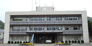
Morioka is the capital city of Iwate Prefecture located in the Tōhoku region of northern Japan. On 1 August 2023, the city had an estimated population of 283,981 in 132,719 households, and a population density of 320 per square kilometre (830/sq mi). The total area of the city is 886.47 square kilometres (342.27 sq mi).

Tono, Tōno or Toño may refer to:

<span class="mw-page-title-main">Shizukuishi</span> Town in Tōhoku, Japan

Shizukuishi is a town located in Iwate Prefecture, Japan. As of 31 March 2020, the town had an estimated population of 16,263 in 6354 households, and a population density of 27 persons per km². The total area of the town is 608.82 square kilometres (235.07 sq mi).

<span class="mw-page-title-main">Shiwa, Iwate</span> Town in Tōhoku, Japan

Shiwa is a town in Iwate Prefecture, Japan. As of 31 March 2020, the town had an estimated population of 33,090, in 12338 households, and a population density of 134 persons per km². The total area of the town is 238.98 square kilometres (92.27 sq mi).

Gando may refer to

<span class="mw-page-title-main">Nishiwaga</span> Town in Tōhoku, Japan

Nishiwaga is a town in Iwate Prefecture, Japan. As of 31 March 2020, the town had an estimated population of 5,468 in 2279 households, and a population density of 9 persons per km². The total area of the town is 590.74 square kilometres (228.09 sq mi). The total area was 825.97 square kilometres (318.91 sq mi).

<span class="mw-page-title-main">Ōshū, Iwate</span> City in Tōhoku, Japan

Ōshū is a city located in Iwate Prefecture, Japan. As of 30 April 2020, the city had an estimated population of 114,620 and a population density of 120 persons per km2 in 45,728 households. The total area of the city is 993.30 square kilometres (383.52 sq mi). Ōshū is famous for its Maesawa Beef, numerous festivals, historic temples and shrines and Fujiwara no Sato, a theme park and movie lot based on the exploits of the Northern Fujiwaras in the 12th century. Many famous people claim Ōshū as their home, including Ichiro Ozawa, the long-time leader of the Democratic Party of Japan.

<span class="mw-page-title-main">Kitakami River</span> River in Japan

The Kitakami River is the fourth largest river in Japan and the largest in the Tōhoku region. It is 249 kilometres (155 mi) long and drains an area of 10,150 square kilometres (3,920 sq mi). It flows through mostly rural areas of Iwate and Miyagi Prefectures. The source of the river is the Mount Nanashigure in northern Iwate, from which it flows to the south between the Kitakami Mountains and the Ōu Mountains. The river is unusual in that it has two mouths, one flowing south into Ishinomaki Bay and the other flowing east into the Pacific Ocean, both in Ishinomaki City.

<span class="mw-page-title-main">Japan National Route 283</span> Road in Iwate prefecture, Japan

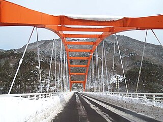
National Route 283 is a national highway connecting Kamaishi, Iwate and Hanamaki, Iwate in Japan, with a total length of 89.3 km (55.49 mi).

<span class="mw-page-title-main">Japan National Route 396</span> Road in Iwate prefecture, Japan

National Route 396 is a national highway of Japan connecting Tōno, Iwate and Morioka, Iwate in Japan, with a total length of 58.7 km (36.47 mi).

<span class="mw-page-title-main">Tase Dam</span> Dam in Iwate, Japan

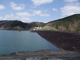
Tase Dam is a multipurpose dam located on the Sarugaishi River in the former town of Tōwa which is now a part of the city of Hanamaki in Iwate Prefecture, in the Tohoku region of northern Japan. Completed in 1954, it is managed by the Tohoku Regional Development Bureau of the Ministry of Land, Infrastructure and Transport. Located on the Sarugaishi River, a branch of the Kitakami River, it is the first of the dams completed as part of the Kitakami Area Comprehensive Development Plan (KVA). The dam creates Lake Tase, a popular sightseeing spot.

<span class="mw-page-title-main">Gandō Dam</span> Dam in Iwate, Japan

Gandō Dam is a dam on the Tandogawa River, a branch of the Kitakami River in Morioka, Iwate Prefecture, Japan, completed in 1960.

<span class="mw-page-title-main">Hayachine Dam</span> Dam in Iwate, Japan

The Hayachine Dam is a multi-purpose dam on the Hienuki River, a branch of the Kitakami River, located in the city of Hanamaki, Iwate Prefecture in the Tōhoku region of northern Japan. It managed by Hanamaki Civil Engineering Center, Minami Kunisaki Promotion Department, and is a gravity-type concrete dam with a bank height of 73.5 meters.

<span class="mw-page-title-main">Irihata Dam</span> Dam in Iwate, Japan

Irihata Dam is a dam in Kitakami, Iwate Prefecture, Japan, completed in 1990.

<span class="mw-page-title-main">Ishibane Dam</span> Dam in Iwate, Japan

Ishibane Dam is a dam in Kitakami, Iwate Prefecture, Japan, completed in 1953.

<span class="mw-page-title-main">Kuzumaru Dam</span> Dam in Iwate, Japan

Kuzumaru Dam is a dam in Hanamaki, Iwate Prefecture, Japan, completed in 1991.

<span class="mw-page-title-main">Toyosawa Dam</span> Dam in Iwate Prefecture, Japan

The Toyosawa Dam is a dam on the Toyosawa River, a tributary of the Kitakami River system, located in the southern portion of the city of Hanamaki, Iwate Prefecture in the Tōhoku region of northern Japan. It was completed in 1961.

<span class="mw-page-title-main">Yuda Onsenkyō Prefectural Natural Park</span>

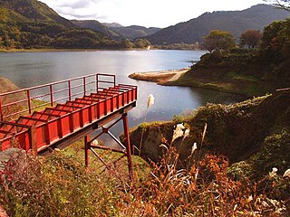
Yuda Onsenkyō Prefectural Natural Park is a Prefectural Natural Park in Iwate Prefecture, Japan. Established in 1961, the park is wholly within the town of Nishiwaga. It encompasses the area around Lake Kinshu reservoir created by Yuda Dam and nearby hot spring resorts

References

  1. 1 2 3 4 5 6 7 8 9 10 11 12 13 14 15 16 17 18 19 20 21 22 23 24 25 26 27 28 29 30 31 Geographic Names Server, Wikidata   Q1194038