List of dams in Miyazaki Prefecture

Last updated

Map of dams in Miyazaki Prefecture.(See Wikidata query)

The following is a list of dams in Miyazaki Prefecture, Japan.

Contents

List

NameLocationOpenedHeight (meters)Image
Ayakita Dam   OOjs UI icon edit-ltr-progressive.svg 32°5′55″N 131°8′34″E 196075.3 Ayakita Dam.jpg
Ayaminami Dam   OOjs UI icon edit-ltr-progressive.svg 32°3′29″N 131°7′14″E 195864 Ayaminami Dam 1976.jpg
Dogawa Dam   OOjs UI icon edit-ltr-progressive.svg 32°21′19″N 131°20′42″E [1] 62.5 Dogawa Dam.jpg
Hamago Dam  OOjs UI icon edit-ltr-progressive.svg 32°39′19″N 131°37′13″E [1] 42.7 [2]
Hamanose Dam   OOjs UI icon edit-ltr-progressive.svg 32°5′40″N 131°0′46″E 201462.5
Hase Dam   OOjs UI icon edit-ltr-progressive.svg 32°8′47″N 131°20′28″E [1] 198165
Higashibaru Choseichi Dam   OOjs UI icon edit-ltr-progressive.svg 32°9′14″N 131°24′42″E 198021
Hirosawa Dam   OOjs UI icon edit-ltr-progressive.svg 32°0′25″N 131°11′12″E [1] 62.7
Hiroto Dam   OOjs UI icon edit-ltr-progressive.svg 31°42′59″N 131°15′59″E [1] 66 Guang Du damu - panoramio.jpg
Hitotsuse Dam   OOjs UI icon edit-ltr-progressive.svg 32°12′25″N 131°18′7″E 1963130 Hitotsuse-2829-r1.JPG
Horigawa Dam  OOjs UI icon edit-ltr-progressive.svg 32°43′5″N 131°34′29″E [1]
Hoshiyama Dam   OOjs UI icon edit-ltr-progressive.svg 32°37′18″N 131°25′39″E 194230.5
Ishikawauchi Dam   OOjs UI icon edit-ltr-progressive.svg 32°14′29″N 131°23′25″E [1] 200747.5 Ishikawauchi-3302-r1.JPG
Iwase Dam   OOjs UI icon edit-ltr-progressive.svg 31°56′32″N 131°8′24″E [1] 196755.5 Iwase-2833-r1.JPG
Iwayato Dam   OOjs UI icon edit-ltr-progressive.svg 32°28′7″N 131°12′42″E 194157.5
Kadogawa Bosai Dam   OOjs UI icon edit-ltr-progressive.svg 32°30′29″N 131°38′26″E [1] 197231
Kamishiiba Dam   OOjs UI icon edit-ltr-progressive.svg 32°27′37″N 131°8′58″E 1955110 [2] Kamishiiba-2815-r1.JPG
Kanasumi Dam  OOjs UI icon edit-ltr-progressive.svg 32°14′58″N 131°21′28″E [3] [4] 200742.5 [2]
Kawabaru Dam   OOjs UI icon edit-ltr-progressive.svg 32°12′48″N 131°25′2″E [1] 193923.6 Xiao Wan Chuan Chuan Yuan damu - panoramio.jpg
Kiribaru Dam   OOjs UI icon edit-ltr-progressive.svg 32°13′6″N 131°28′2″E 201261.3
Koganekyo Dam   OOjs UI icon edit-ltr-progressive.svg 32°4′35″N 131°10′38″E 195832
Konokawauchi Dam   OOjs UI icon edit-ltr-progressive.svg 31°52′10″N 131°0′35″E 200964.3
Kuwanouchi Dam   OOjs UI icon edit-ltr-progressive.svg 32°43′49″N 131°12′22″E [1] 195526.5
Madonose Dam  OOjs UI icon edit-ltr-progressive.svg 32°42′49″N 131°17′57″E [1]
Matsuo Dam   OOjs UI icon edit-ltr-progressive.svg 32°17′4″N 131°22′15″E [1] 68 [2]
Miyanomoto Dam   OOjs UI icon edit-ltr-progressive.svg 32°33′58″N 131°16′41″E [1] 18.5 [2] Miyanomoto-2825-r1.JPG
Morozuka Dam   OOjs UI icon edit-ltr-progressive.svg 32°33′36″N 131°19′12″E 196059 Morodsuka-2824-r1.JPG
Nichinan Dam   OOjs UI icon edit-ltr-progressive.svg 31°38′26″N 131°16′24″E [1] 47 [2]
Nishihata Dam   OOjs UI icon edit-ltr-progressive.svg 32°40′22″N 131°26′53″E [1] 17.8 [2]
Okita Dam   OOjs UI icon edit-ltr-progressive.svg 32°33′2″N 131°37′10″E [1] 36 [2]
Oseuchi Dam   OOjs UI icon edit-ltr-progressive.svg 32°14′49″N 131°21′44″E [1] 65.5 [2]
Ouchibaro Dam   OOjs UI icon edit-ltr-progressive.svg 32°25′47″N 131°28′53″E [1] 25.5 [2]
Oyodogawa No.1 Dam   OOjs UI icon edit-ltr-progressive.svg 31°55′8″N 131°8′3″E [1] 47 [2] Oyodogawa No1-2826-r1.JPG
Oyodogawa No.2 Dam  OOjs UI icon edit-ltr-progressive.svg 31°56′15″N 131°12′21″E [1] Oyodogawa II power station secondary reservoir survey 1974.jpg
Sabukawa Dam   OOjs UI icon edit-ltr-progressive.svg 32°6′57″N 131°17′8″E [1] 33.5 [2]
Saigo Dam   OOjs UI icon edit-ltr-progressive.svg 32°27′31″N 131°24′10″E [1] Saigo Dam.JPG
Shimoaka Dam   OOjs UI icon edit-ltr-progressive.svg 32°45′1″N 131°37′49″E [2] 17.8 [2] Shimoaka-2827-r1.JPG
Sugiyasu Dam   OOjs UI icon edit-ltr-progressive.svg 32°9′46″N 131°21′33″E [1] 39.5 [2] Sugiyasu Dam Aerial Photograph.jpg
Tachibana Dam   OOjs UI icon edit-ltr-progressive.svg 32°7′57″N 131°16′6″E [1] 71.3 [2] Tachibana Dam.jpg
Takaoka Dam   OOjs UI icon edit-ltr-progressive.svg 31°56′15″N 131°12′21″E [2] 38.9 [2] Takaoka Dam survey 1974.jpg
Tashirohae Dam   OOjs UI icon edit-ltr-progressive.svg 32°8′9″N 131°7′20″E 64.6 [2] Tashirobae Dam.jpg
Tenjin Dam   OOjs UI icon edit-ltr-progressive.svg 31°49′7″N 131°13′49″E [1] 62.5 [2]
Torinosu Dam  OOjs UI icon edit-ltr-progressive.svg 32°29′54″N 131°22′4″E [1]
Tosaki Dam  OOjs UI icon edit-ltr-progressive.svg 32°15′0″N 131°23′2″E [1]
Tsukabaru Dam   OOjs UI icon edit-ltr-progressive.svg 32°30′19″N 131°18′0″E [1] 199387 [2] Tsukabaru-2808-r1.JPG
Urita Dam   OOjs UI icon edit-ltr-progressive.svg 31°55′35″N 131°18′26″E [1] 42 [2] Gua Tian damu - panoramio.jpg
Ushiyama Dam  OOjs UI icon edit-ltr-progressive.svg 32°23′39″N 131°17′5″E [1]
Yamase Dam  OOjs UI icon edit-ltr-progressive.svg 32°32′54″N 131°16′1″E [1]
Yamasubaru Dam   OOjs UI icon edit-ltr-progressive.svg
Yanagihara Dam  OOjs UI icon edit-ltr-progressive.svg 32°32′41″N 131°19′38″E [1]

See also

Related Research Articles

<span class="mw-page-title-main">Miyazaki Prefecture</span> Prefecture of Japan

Miyazaki Prefecture is a prefecture of Japan located on the island of Kyūshū. Miyazaki Prefecture has a population of 1,073,054 as of 1 June 2019 and has a geographic area of 7,735 km2. Miyazaki Prefecture borders Ōita Prefecture to the north, Kumamoto Prefecture to the northwest, and Kagoshima Prefecture to the southwest.

<span class="mw-page-title-main">Saito, Miyazaki</span> City in Kyushu, Japan

Saito is a city located in Miyazaki Prefecture, Japan. As of 1 November 2023, the city had an estimated population of 28,53 in 13964 households, and a population density of 65 persons per km2. The total area of the city is 438.79 km2 (169.42 sq mi).

<span class="mw-page-title-main">Ōno River</span> River in Ōita, Japan

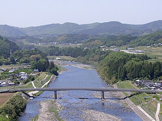
The Ōno River is a river that originates in Ōita Prefecture, Japan. After running through the southern and central portions of Ōita Prefecture, it runs through the eastern part of Kumamoto Prefecture and the northern part of Miyazaki Prefecture.

<span class="mw-page-title-main">Nishimera, Miyazaki</span> Village in Kyushu, Japan

Nishimera is a village located in Koyu District, Miyazaki Prefecture, Japan. As of 1 October 2023, the village had an estimated population of 1,040 in 533 households, and a population density of 3.8 persons per km². The total area of the village is 271.51 square kilometres (104.83 sq mi).

<span class="mw-page-title-main">Kijō, Miyazaki</span> Town in Kyushu, Japan

Kijō is a town located in Koyu District, Miyazaki Prefecture, Japan. As of 1 October 2023, the town has an estimated population of 4,642 in 1857 households, and a population density of 32 persons per km². The total area of the town is 145.96 square kilometres (56.36 sq mi).

<span class="mw-page-title-main">Japan National Route 326</span> Road in Japan

National Route 326 is a national highway of Japan connecting Nobeoka, Miyazaki and Bungo-ōno, Ōita in Japan, with a total length of 68.3 km (42.44 mi).

<span class="mw-page-title-main">Miyanomoto Dam</span> Dam in Miyazaki Prefecture, Japan

Miyanomoto Dam is a dam in Miyazaki Prefecture, Japan. It was completed in 1961.

<span class="mw-page-title-main">Morozuka Dam</span> Dam in Miyazaki Prefecture, Japan

Morozuka Dam is a dam in Miyazaki Prefecture, Japan, completed in 1961.

<span class="mw-page-title-main">Mimi River (Japan)</span> River in Miyazaki Prefecture, Japan

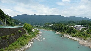
Mimi River is a river of Japan. It flows through the Miyazaki Prefecture. There is cascade of six dams built on the river with two dams in the upstream basin of the Tsukabaru Dam and three dams on the downstream.

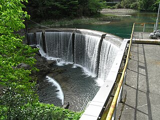
Yamasubaru Dam is a dam in Miyazaki Prefecture, Japan, completed in 1932. It dams the Mimi River.

References

  1. 1 2 3 4 5 6 7 8 9 10 11 12 13 14 15 16 17 18 19 20 21 22 23 24 25 26 27 28 29 30 31 32 33 Geographic Names Server, Wikidata   Q1194038
  2. 1 2 3 4 5 6 7 8 9 10 11 12 13 14 15 16 17 18 19 20 21 22 Dams in Japan, Japan Dam Foundation, Wikidata   Q113763464
  3. Structurae (in English, French, and German), Ratingen, LCCN   2004564817, Wikidata   Q1061861
  4. https://structurae.net/en/structures/kanasumi-dam