List of dams in Okayama Prefecture

Last updated

Map of dams in Okayama Prefecture.(See Wikidata query)

The following is a list of dams in Okayama Prefecture, Japan.

Contents

List

NameLocationOpenedHeight (meters)Image
Abekura Dam  OOjs UI icon edit-ltr-progressive.svg 34°45′18″N 133°50′41″E [1]
Aono Dam  OOjs UI icon edit-ltr-progressive.svg 34°38′35″N 133°28′38″E [1] 20 [2]
Asahikawa Dam   OOjs UI icon edit-ltr-progressive.svg 34°54′49″N 133°51′23″E 45 [2] Asahikawa-1867-r1.jpg
Asahigawa No.2 Dam  OOjs UI icon edit-ltr-progressive.svg 34°54′10″N 133°52′45″E [1]
Chiaraiike Dam  OOjs UI icon edit-ltr-progressive.svg 34°56′3″N 134°1′53″E [1] 15 [2]
Chiya Dam   OOjs UI icon edit-ltr-progressive.svg 35°3′24″N 133°27′25″E 97.5 [2] Chiya Dam view from the front.jpg
Doyo Dam   OOjs UI icon edit-ltr-progressive.svg 35°13′53″N 133°32′42″E 198686.7 [2] Doyo-1904-r1.JPG
Hattojikawa Dam  OOjs UI icon edit-ltr-progressive.svg 34°52′16″N 134°15′2″E [1] 44 [2]
Higasa Dam  OOjs UI icon edit-ltr-progressive.svg 34°52′3″N 134°10′22″E [1]
Hiyama Dam  OOjs UI icon edit-ltr-progressive.svg 34°53′18″N 133°49′50″E [1] 25.4 [2]
Hokubo Dam   OOjs UI icon edit-ltr-progressive.svg 35°0′3″N 133°35′58″E [1] 198035.3 Hokubo Dam 1.jpg
Hoshida No.2 Dam  OOjs UI icon edit-ltr-progressive.svg 34°38′32″N 133°31′53″E [1] 42.6 [2]
Kagami Dam  OOjs UI icon edit-ltr-progressive.svg 35°12′44″N 133°59′7″E [1] 39 [2]
Kawahira Dam  OOjs UI icon edit-ltr-progressive.svg 34°52′26″N 133°49′19″E [1] 38.5 [2]
Kawakami Dam  OOjs UI icon edit-ltr-progressive.svg 35°7′13″N 134°18′13″E [1] 24 [2]
Komoto Dam   OOjs UI icon edit-ltr-progressive.svg 34°57′44″N 133°27′24″E [1] 60 [2] Koumoto Dam view from right side.jpg
Kuga Dam  OOjs UI icon edit-ltr-progressive.svg 35°6′2″N 134°13′37″E [1] 36.5 [2]
Kurodani Dam   OOjs UI icon edit-ltr-progressive.svg 34°47′19″N 133°47′44″E [1] 30 [2] Kurodani Dam 3.jpg
Kurodori Dam   OOjs UI icon edit-ltr-progressive.svg 34°47′14″N 133°26′58″E 15.5 [2] Kurodori Dam 1.jpg
Kurogi Dam  OOjs UI icon edit-ltr-progressive.svg 35°13′34″N 134°2′20″E [1]
Makidani Dam  OOjs UI icon edit-ltr-progressive.svg 34°46′22″N 133°43′44″E [1] 45 [2]
Meiji Dam   OOjs UI icon edit-ltr-progressive.svg 34°40′43″N 133°25′38″E [1] 199333.4 Meiji Dam01.JPG
Mimurogawa Dam   OOjs UI icon edit-ltr-progressive.svg 35°2′2″N 133°20′24″E 74.5 [2] Mimurogawa Dam 1.jpg
Nagahara Dam  OOjs UI icon edit-ltr-progressive.svg 34°59′40″N 133°59′30″E [1] 27 [2]
Narai Dam  OOjs UI icon edit-ltr-progressive.svg 34°47′57″N 133°39′17″E [1] 38.2 [2] You Jing damu - panoramio.jpg
Narutaki Dam  OOjs UI icon edit-ltr-progressive.svg 34°49′23″N 133°46′17″E [1] 34 [2] Ming Long damu - panoramio (1).jpg
Nishihara Dam  OOjs UI icon edit-ltr-progressive.svg 35°7′32″N 134°12′10″E [1] 46.1 [2]
Ochiai Dam  OOjs UI icon edit-ltr-progressive.svg 34°48′1″N 133°43′48″E [1] 35.7 [2]
Onbara Dam   OOjs UI icon edit-ltr-progressive.svg 35°18′1″N 133°59′15″E 24 [2] Onbara-1852-r1.JPG
Ongi Dam  OOjs UI icon edit-ltr-progressive.svg 34°56′28″N 133°44′29″E [1] 30.8 [2]
Onigatake Dam  OOjs UI icon edit-ltr-progressive.svg 34°41′4″N 133°35′34″E [1] 39 [2]
Osa Dam   OOjs UI icon edit-ltr-progressive.svg 35°7′8″N 133°33′0″E [1] 43.7 [2] Osa Dam 1.jpg
Osakabegawa Dam   OOjs UI icon edit-ltr-progressive.svg 34°58′50″N 133°31′52″E [1] 67.2 [2] Osakabegawa Dam 1.jpg
Otake Dam  OOjs UI icon edit-ltr-progressive.svg 34°43′15″N 133°25′56″E [1] 26.9 [2]
Shin-Nariwagawa Dam   OOjs UI icon edit-ltr-progressive.svg 34°49′23″N 133°24′2″E [1] 103 [2] Shin-Nariwagawa Dam 1.jpg
Tabara Dam   OOjs UI icon edit-ltr-progressive.svg 34°48′37″N 133°25′30″E [1] 41 [2] Tabara Dam 3.jpg
Takasegawa Dam   OOjs UI icon edit-ltr-progressive.svg 35°4′28″N 133°21′28″E [1] 67 [2] Takasegawa Dam 2.jpg
Taketani Dam  OOjs UI icon edit-ltr-progressive.svg 34°51′50″N 133°42′36″E [1] 38 [2]
Takimiya Dam  OOjs UI icon edit-ltr-progressive.svg 34°55′48″N 134°12′27″E [1]
Takiyama Dam  OOjs UI icon edit-ltr-progressive.svg 34°54′56″N 134°2′10″E [1] 33.2 [2]
Tomata Dam   OOjs UI icon edit-ltr-progressive.svg 35°7′38″N 133°53′38″E 74 [2] Tomata Dam 4.jpg
Tsugawa Dam  OOjs UI icon edit-ltr-progressive.svg 35°10′4″N 134°6′33″E [1] 76 [2]
Yamate Dam  OOjs UI icon edit-ltr-progressive.svg 34°53′34″N 133°58′6″E [1] 24 [2]
Yubara Dam   OOjs UI icon edit-ltr-progressive.svg 35°12′29″N 133°43′58″E [2] 73.5 [2] Yubara Dam 2.jpg

See also

Related Research Articles

<span class="mw-page-title-main">Okayama Prefecture</span> Prefecture of Japan

Okayama Prefecture is a prefecture of Japan located in the Chūgoku region of Honshu. Okayama Prefecture has a population of 1,906,464 and has a geographic area of 7,114 km2. Okayama Prefecture borders Tottori Prefecture to the north, Hyōgo Prefecture to the east, and Hiroshima Prefecture to the west.

<span class="mw-page-title-main">Yubara, Okayama</span> Former municipality in Chūgoku, Japan

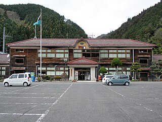
Yubara was a town located in Maniwa District, Okayama Prefecture, Japan.

<span class="mw-page-title-main">Maniwa</span> City in Chūgoku, Japan

Maniwa is a city located in Okayama Prefecture, Japan. As of 1 February 2023, the city had an estimated population of 42,477 in 17568 households and a population density of 51 persons per km2. The total area of the city is 828.53 square kilometres (319.90 sq mi).

<span class="mw-page-title-main">Okayama</span> Designated city in Chūgoku, Japan

Okayama is the capital city of Okayama Prefecture in the Chūgoku region of Japan. The Okayama metropolitan area, centered around the city, has the largest urban employment zone in the Chugoku region of western Japan. The city was founded on June 1, 1889. As of February 2023, the city has an estimated population of 700,940 and a population density of 890 persons per km2. The total area is 789.95 square kilometres.

<span class="mw-page-title-main">Chiya Dam</span> Dam in Okayama, Japan

Chiya Dam is a dam constructed near the origin of the class A Takahasi river, located in Niimi, Okayama Prefecture, Japan.

<span class="mw-page-title-main">Hokubō Dam</span> Dam in Okayama, Japan

Hokubō Dam is a dam in Okayama Prefecture, Japan. It is located on the border between the cities of Maniwa and Niimi, and it is actually situated between the eastbound and westbound lanes of the Chūgoku Expressway. The dam was completed in 1980.

<span class="mw-page-title-main">Kōmoto Dam</span> Dam in Okayama, Japan

Komoto Dam is a dam in Niimi, Okayama Prefecture, Japan, completed in 1964.

<span class="mw-page-title-main">Kurodori Dam</span> Dam in Okayama, Japan

Kurodori Dam is a dam on the Nariwa River in Takahashi, Okayama Prefecture, Japan, completed in 1968.

<span class="mw-page-title-main">Meiji Dam</span> Dam in Okayama Prefecture, Japan

Meiji Dam is a concrete dam near Ibara, Okayama Prefecture, Japan, completed in 1993. It was built for irrigation purposes.

<span class="mw-page-title-main">Mimurogawa Dam</span> Dam in Okayama Prefecture, Japan

Mimurogawa Dam is a dam in the Okayama Prefecture, Japan, completed in 2005.

<span class="mw-page-title-main">Onbara Dam</span> Dam in Okayama Prefecture, Japan

Onbara Dam is a dam in the Okayama Prefecture, Japan, completed in 1927.

<span class="mw-page-title-main">Osa Dam</span> Dam in Okayama Prefecture, Japan

Osa Dam is a dam in the Okayama Prefecture, Japan, completed in 1981.

<span class="mw-page-title-main">Osakabegawa Dam</span> Dam in Okayama Prefecture, Japan

Osakabegawa Dam is a dam in the Okayama Prefecture, Japan, completed in 1954.

<span class="mw-page-title-main">Shin-Nariwagawa Dam</span> Dam in Okayama Prefecture, Japan

Shin-Nariwagawa Dam is a dam in the Okayama Prefecture, Japan, completed in 1968.

<span class="mw-page-title-main">Tabara Dam</span> Dam in Okayama Prefecture, Japan

Tabara Dam is a dam in the Okayama Prefecture, Japan, completed in 1968.

<span class="mw-page-title-main">Takasegawa Dam</span> Dam in Okayama Prefecture, Japan

Takasegawa Dam is a dam in the Okayama Prefecture, Japan, completed in 1982.

<span class="mw-page-title-main">Tomata Dam</span> Dam in Okayama Prefecture, Japan

Tomata Dam is a dam in the Okayama Prefecture, Japan, completed in 2004.

<span class="mw-page-title-main">Yubara Dam</span> Dam in Okayama Prefecture, Japan

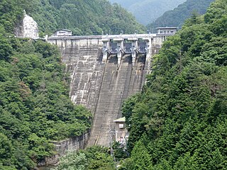
Yubara Dam is a dam in Okayama Prefecture, Japan, completed in 1954.

<span class="mw-page-title-main">Asahigawa Dam</span> Dam in Okayama, Japan

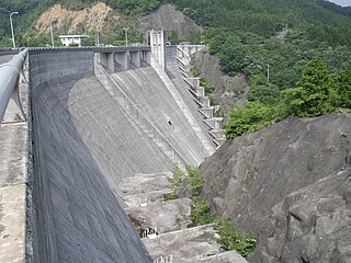
Asahigawa Dam is a dam on Asahi River straddling the border between Kibichūō and northern Takebe, Okayama in Okayama Prefecture, Japan. The dam was completed in 1954.

References

  1. 1 2 3 4 5 6 7 8 9 10 11 12 13 14 15 16 17 18 19 20 21 22 23 24 25 26 27 28 29 30 31 32 33 34 35 36 Geographic Names Server, Wikidata   Q1194038
  2. 1 2 3 4 5 6 7 8 9 10 11 12 13 14 15 16 17 18 19 20 21 22 23 24 25 26 27 28 29 30 31 32 33 34 35 36 37 38 Dams in Japan, Japan Dam Foundation, Wikidata   Q113763464