List of municipal roads in Markham, Ontario

Last updated
Sample road signs found along Markham's municipal roads. Dension StreetSign.PNG
Sample road signs found along Markham's municipal roads.

While most major roads in Markham, Ontario are funded by the York Regional government, some of the main roads are funded by the Markham government. These roads are named as municipal roads. These municipal roads are served for motorists to travel within the city. The Markham government also funded all of the local, light-duty Collector roads. This article lists all the major municipal roads funded by Markham.

Contents

Regional roads are maintained by York Region Transportation Services Department and all other roads by the City of Markham's Operations Department.

North-South routes

Road nameNorthern EndSouthern EndLength (km) [1] Additional notes
Aileen Road Green Lane John Street 0.4
Allstate Parkway Toronto/Buttonville Airport York Regional Road 7.svg Highway 7 1.1Named for the location of the former Allstate's Canada Head Office building, now home to Seneca College Markham campus.
Birchmount Road York Regional Road 7.svg Highway 7 Steeles Avenue 2.4Continuation of street from with City of Toronto; extension from 14th Avenue do serve as future principle artery of Downtown Markham.
Brimley Road York Regional Road 71.svg 14th Avenue Steeles Avenue 2.1Continuation of street from with City of Toronto.
Cornell Centre Boulevard York Regional Road 73.svg 16th Avenue Ontario 7.svg Highway 7 Eastern border of the community of Cornell;
Alternative route to relieve traffic congestion on Main Street Markham and Ninth Line;
Former alignment of York Regional Road 48. Formerly named as the Old Markham By-Pass in reference of traffic bypassing Markham Village and Main Street Markham. Current name linked with the community of Cornell, Ontario.
Henderson Avenue Toronto Ladies' Golf Course Steeles Avenue 2.5Major thoroughfare in Community of Thornhill. Connects with Maxome Avenue in Toronto to the south of Steeles Avenue.
Laureleaf Road York Regional Road 34.svg Bayview Avenue Steeles Avenue 1.7Connects with City of Toronto with a street with the same name (signed as Laureleaf Road South)
Main Street Unionville Rosemead CloseEnterprise Drive2.75Street name linked to the community of Unionville, Ontario. Major tourist area of the city of Markham.
Formerly the alignment of present-day York Regional Road 3.
Middlefield Road York Regional Road 71.svg 14th Avenue Steeles Avenue Continuation of of road from with City of Toronto with a street with the same name; eastern border of the Community of Milliken.
Mingay Avenue York Regional Road 25.svg Major MacKenzie Drive York Regional Road 73.svg 16th Avenue Main route in the Community of Wismer Common and named for Mingay family who are related to the Cornell settlers of Markham including lawyer and former Deputy Reeve of Markham Paul Mingay.
Old Kennedy Road Denison Street Steeles Avenue Formerly the alignment of present-day York Regional Road 3 (Kennedy Road). Connects with City of Toronto as Silver Star Boulevard. Section north of Denison renamed as Frenso Court.
Reesor Road19th Avenue York Regional Road 29.svg York Regional Road 29 Steeles Avenue East (York Regional Road 95)12Continues north of 19th as Tenth Line then merges with York-Durham Town Line (York Regional Road 30) in Lincolnville, Ontario. Street is continuation of street with same name in Toronto. South of Steeles Avenue road ends at Finch Avenue East at Toronto Zoo.
Rodick Road York Regional Road 8.svg Woodbine Avenue Riviera Drive 6.8Western border of Downtown Markham.
Roy Rainey Avenue York Regional Road 25.svg Major MacKenzie Drive York Regional Road 73.svg 16th Avenue Road is named for Private Roy Rainey of Unionville who died in 1918 as member of the 3rd Battalion of the Canadian Infantry (Central Ontario Regiment) in Somme, France [2]
Stonebridge Drive York Regional Road 25.svg Major MacKenzie Drive York Regional Road 73.svg 16th Avenue
The Bridle Walk York Regional Road 25.svg Major MacKenzie Drive York Regional Road 73.svg 16th Avenue Passes through the heart of the community of Berczy Village.
Town Centre Boulevard Apple Creek Boulevard York Regional Road 7.svg Highway 7 Many important structures of the city locate on this road. Roads name was based on the location of the Markham Civic Centre which served as Town Centre before 2012.
Victoria Park Avenue Denison Street Steeles Avenue Street is continuation of street with same name in Toronto.
Village Parkway York Regional Road 73.svg 16th Avenue York Regional Road 7.svg Highway 7 Western border of Community of Unionville.
Future connection to Birchmount Road that currently terminates south of Highway 7.
Willowbrook Road York Regional Road 34.svg Bayview Avenue Green Lane 1.9

East-West routes

Road nameEastern endWestern endLength (km) [1] Additional information
14th Avenue Alden Road Ontario 404.svg Highway 404 Although most of 14th Avenue is marked as Regional Road 71, the section west of Warden is municipal-funded. Former sideroad between lots 5 and 6. [3] Council debated renaming the road, as "4" is considered unlucky by Chinese. [4]
19th Avenue York Regional Road 30.svg York-Durham Line York Regional Road 8.svg Woodbine Avenue Although parts of 19th Avenue is marked as Regional Road 29, the section east of Woodbine is municipal-funded; 19th Avenue is the northernmost municipal road in Markham. Former sideroad between lots 30 and 31. [3]
Alden Road York Regional Road 65.svg Warden Avenue Esna Park Drive Along with John Street and the section of Esna Park Drive west of Alden, it bridges the two separate sections of York Regional Road 71.
Apple Creek Boulevard York Regional Road 65.svg Warden Avenue York Regional Road 8.svg Woodbine Avenue Northern border of Downtown Markham. Named for small waterway and Rouge River tributary in the area Apple Creek.
Bullock Drive York Regional Road 68.svg Main Street Markham North York Regional Road 7.svg Highway 7
Bur Oak Avenue York Regional Road 7.svg Highway 7 York Regional Road 3.svg Kennedy Road 11.0Major thoroughfare in Berczy Village, Wismer Common, Greensborough, and Cornell
Carlton Road York Regional Road 67.svg McCowan Road York Regional Road 65.svg Warden Avenue Major thoroughfare in Unionville.
Castlemore Avenue York Regional Road 69.svg Ninth Line York Regional Road 3.svg Kennedy Road
Clark Avenue East Sprucewood Drive York Regional Road 1.svg Yonge Street 1.6Connects with Vaughan.
Denison Street Bethany StreetSteelcase Road West9.9Serve as an alternative to the traffic congested Steeles Avenue.
Major thoroughfare for Milliken.
Elgin Mills Road East York Regional Road 30.svg York-Durham Line York Regional Road 8.svg Woodbine Avenue Although most of Elgin Mills Road is marked as Regional Road 49, the section east of Woodbine is municipal-funded. Originally Eighteenth Avenue, the sideroad between lots 25 and 26. Elgin Mills was a small community on Yonge. [5] Was a post office established in 1900 and named for James Bruce, Earl of Bruce. [6]
Elson Street Denison Street York Regional Road 67 3.2Named for former Ward 6 town councillor Elson Miles.
Enterprise Drive Main Street Unionville York Regional Road 65.svg Warden Avenue 2.5Major thoroughfare of Downtown Markham, connects with Yorktech Drive, Unionville Gate, and South Unionville Avenue as an alternative to York Regional Road 7.
Esna Park Drive Steeles Avenue York Regional Road 8.svg Woodbine Avenue Along with Alden Road and John Street, the section west of Alden Road bridges the two separate sections of York Regional Road 71; connects with Toronto.
Fred Varley Drive Main Street Unionville Carlton Road Named for Group of Seven member Fred Varley
Green Lane York Regional Road 12.svg Leslie Street York Regional Road 34.svg Bayview Avenue 2.6Northern border of German Mills.
John Street York Regional Road 8.svg Woodbine Avenue York Regional Road 1.svg Yonge Street 6.125Along with Alden Road and the section of Esna Park Drive west of Alden, it bridges the two separate sections of York Regional Road 71; major thoroughfare in German Mills and Thornhill. Believed to be named for John Colborne, Lieutenant Governor of Upper Canada
Langstaff Road East York Regional Road 34.svg Bayview Avenue York Regional Road 1.svg Yonge Street 2.3Cut off from the rest of Langstaff Road by Highway 7
Highglen Avenue York Regional Road 68.svg Markham Road York Regional Road 3.svg Kennedy Road
Raymerville Drive York Regional Road 67.svg McCowan Road York Regional Road 67.svg McCowan Road 4.5An U-shape major thoroughfare forming the backbone of the community Raymerville - Markville East. Likely named for Raymer family.
Royal Orchard Boulevard York Regional Road 34.svg Bayview Avenue York Regional Road 1.svg Yonge Street 2.2Major thoroughfare of Langstaff.
South Unionville Avenue York Regional Road 67.svg McCowan Road York Regional Road 3.svg Kennedy Road Future major thoroughfare of Downtown Markham; connects with Yorktech Drive, Enterprise Drive, and Unionville Gate to form an alternative route to York Regional Road 7.
Yorktech Drive York Regional Road 65.svg Warden Avenue York Regional Road 8.svg Woodbine Avenue Future major thoroughfare of Downtown Markham, and will connect to Enterprise Drive, Unionville Gate, and South Unionville Avenue to form an alternative route to York Regional Road 7.

*Italics indicate future termini.

See also

Related Research Articles

Markham, Ontario City in Ontario, Canada

Markham is a city in the Regional Municipality of York in Southern Ontario, Canada. It is approximately 30 km (19 mi) northeast of Downtown Toronto. In the 2016 Census, Markham had a population of 328,940, which ranked it the largest in York Region, fourth largest in the Greater Toronto Area (GTA), and 16th largest in Canada.

Richmond Hill, Ontario City in Ontario, Canada

Richmond Hill is a city in south-central York Region, Ontario, Canada. Part of the Greater Toronto Area, it is the York Region's third most populous municipality and the 28th most populous municipality in Canada.

Regional Municipality of York Regional municipality in Ontario, Canada

The Regional Municipality of York, also called York Region, is a regional municipality in Southern Ontario, Canada, between Lake Simcoe and Toronto. It replaced the former York County in 1971, and is part of the Greater Toronto Area and the inner ring of the Golden Horseshoe. The regional government is headquartered in Newmarket.

Ontario Highway 407 Tolled highway in Ontario

King's Highway 407 is a tolled 400-series highway in the Canadian province of Ontario. Comprising a privately leased segment as well as a publicly owned segment, the route spans the entire Greater Toronto Area (GTA) around the city of Toronto, travelling through the suburbs of Burlington, Oakville, Mississauga, Brampton, Vaughan, Markham, Pickering, Whitby, and Oshawa before ending in Clarington, north of Orono. At 151.4 km long, this is the fourth longest freeway in Ontario's 400 series network, after Highways 417, 400, and 401. The segment between Burlington and Brougham in Pickering is leased to and operated by the 407 ETR Concession Company Limited and is officially known as the 407 Express Toll Route (407 ETR). It begins at the junction of the Queen Elizabeth Way (QEW) and Highway 403 in Burlington, and travels 108.0 km (67.1 mi) across the GTA to Brock Road in Pickering. East of Brock Road, the tollway continues east as Highway 407, a toll route operated by the provincial government, for 43.4 km (27.0 mi) to Highway 35/115 in Clarington. The route interchanges with nine freeways: the QEW, Highway 403, Highway 401, Highway 410, Highway 427, Highway 400, Highway 404, Highway 412, and Highway 418. Highway 407 is an electronically operated toll highway; there are no toll booths along the length of the route. Distances are calculated automatically using transponders or automatic number-plate recognition, which are scanned at entrance and exit points.

King, Ontario Township in Ontario, Canada

King is a township in York Region north of Toronto, within the Greater Toronto Area in Ontario, Canada.

Rouge River (Ontario) River in Ontario, Canada

The Rouge River is a river in Markham, Pickering, Richmond Hill and Toronto in the Greater Toronto Area of Ontario, Canada. The river flows from the Oak Ridges Moraine to Lake Ontario at the eastern border of Toronto, and is the location of Rouge Park, the only national park in Canada within a municipality. At its southern end, the Rouge River is the boundary between Toronto and southwestern Pickering in the Regional Municipality of Durham.

Ontario Highway 7 Ontario provincial highway

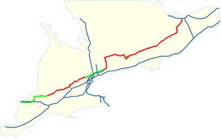
King's Highway 7, commonly referred to as Highway 7 and historically as the Northern Highway, is a provincially maintained highway in the Canadian province of Ontario. At its peak, Highway 7 measured 716 km (445 mi) in length, stretching from Highway 40 east of Sarnia in Southwestern Ontario to Highway 17 west of Ottawa in Eastern Ontario. However, due in part to the construction of Highways 402 and 407, the province transferred the sections of Highway 7 west of London and through the Greater Toronto Area to county and regional jurisdiction. The highway is now 535.7 km (332.9 mi) long; the western segment begins at Highway 4 north of London and extends 154.1 km (95.8 mi) to Georgetown, while the eastern segment begins at Donald Cousens Parkway in Markham and extends 381.6 km (237.1 mi) to Highway 417 in Ottawa.

Steeles Avenue

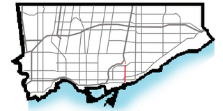
Steeles Avenue is an east–west street that forms the northern city limit of Toronto and the southern limit of York Region, Ontario, Canada. It stretches 77.3 km (48.0 mi) across the western and central Greater Toronto Area from Appleby Line in Milton in the west to the Toronto-Pickering city limits in the east, where it continues east into Durham Region as Taunton Road, which itself extends 58 km (36 mi) across the length of Durham Region to its boundary with Northumberland County.

King's Highway 48, also known as Highway 48, is a provincially maintained highway in southern Ontario that extends from Major Mackenzie Drive in Markham, through Whitchurch-Stouffville and East Gwillimbury, to Highway 12 south-east of Beaverton. The route is generally rural and straight, passing near several communities within the Regional Municipality of York. The route is 65.2 kilometres (40.5 mi) long. Most part of the road has a speed limit of 80 km/h (50 mph), except within town limits, where the speed limit is reduced to 60 km/h (37 mph) or 50 km/h (31 mph).

Viva Rapid Transit

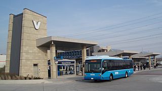
Viva is the bus rapid transit operations of York Region Transit in York Region, Ontario, Canada. Viva service forms the spine for YRT's local bus service, providing seamless transit service across York Region with connections to northern Toronto.

Milliken, Ontario Neighbourhood in Ontario, Canada

Milliken and Milliken Mills are neighbourhoods in the cities of Toronto and Markham. Milliken is situated in the north west section of Scarborough, whereas Milliken Mills is situated in the south-central portions of Markham. The neighbourhoods are centered on Kennedy Road and Steeles Avenue, the latter street serving as the boundary between the cities of Markham and Toronto.

York Region Paramedic Services

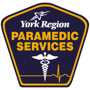
York Region Paramedic Services provides legislated land ambulance services and paramedic care for the local municipalities within York Region. Paramedic Services is a division of the Region's Paramedic and Seniors Service Branch. Prior to 2000, ambulance services were provided by 2 private operators, York County Hospital, Nobleton Volunteer Ambulance and Ontario's Ministry of Health. The patchwork of service also had York Region dispatched by 3 different Ministry of Health Communication Centres. Georgian CACC now dispatches the whole region on the Ontario Government leased Bell Mobility Fleetnet VHF trunked radio system. There are approximately 480 full-time paramedics serving the region. Paramedic Operations are based in East Gwillimbury, Ontario.

John Street is an east-west collector and arterial road in the city of Markham, Ontario, Canada. It is one of the oldest roads in the city of Markham and forms the backbone of the 200-year-old community of Thornhill.

Donald Cousens Parkway Arterial bypass of Markham

Donald Cousens Parkway or York Regional Road 48, also referred to historically as the Markham Bypass or Markham Bypass Extension, is a regionally maintained arterial bypass of Markham in the Canadian province of Ontario. Named for former Markham mayor Don Cousens in April 2007, the route initially travelled northward from Copper Creek Drive in Box Grove, south of Highway 407, to Major Mackenzie Drive. A southern extension to Steeles Avenue was later completed and the name Donald Cousens Parkway applied along the extension to Ninth Line. In addition to its role of funneling through-traffic around downtown Markham, the route serves as a boundary to residential development as land to the north and east are part of the protected Rouge National Urban Park and southwest limits of the planned Pickering Airport.

The city of Markham in Ontario, Canada, offers a complex transportation infrastructure. These include airports, highways, public transit, regional roads, municipality-funded roads, and train services.

The City of Vaughan in Ontario, Canada offers a complex transportation infrastructure, which includes highways, public transit, regional roads, municipality-funded roads, and train services.

Woodbine Avenue

Woodbine Avenue consists of three north–south road sections in the Greater Toronto Area, Canada:

  1. The southern section in Toronto begins near Ashbridges Bay on the shore of Lake Ontario, at Lake Shore Boulevard. Woodbine then continues north to O'Connor Drive.
  2. The middle section in Toronto begins, under the name Woodbine Heights Drive, across the Massey Taylor Creek, in the Parkview Heights neighbourhood. Following the southern alignment of Woodbine, it continues for four blocks and ends at the East Don Valley. Had the alignment of the O'Connor Bridge been north–south instead of southwest–northeast, this section would have been joined with the southern segment.
  3. The northern section runs from Steeles Avenue at the Toronto-Markham border to the shore of Lake Simcoe, ending at Lake Drive in Georgina. York Region designates this section as an arterial road numbered as York Regional Road 8. It runs parallel to Highway 404.

Secondary Highway 536, commonly referred to as Highway 536, was a provincially maintained secondary highway in the Canadian province of Ontario. This highway connected Highway 17 near Lively with Wellington Street at the Creighton Mine. Highway 536 followed most of what is now Municipal Road 24, north from Greater Sudbury Road 55. The route existed from 1956 until the formation of the Regional Municipality of Sudbury in 1973.

References

  1. 1 2 "Google Maps". Google. Retrieved 16 February 2019.
  2. https://www.veterans.gc.ca/eng/remembrance/memorials/canadian-virtual-war-memorial/detail/576604
  3. 1 2 "Tremain Map York". 1860. Retrieved 2018-02-24.
  4. O'Toole, Megan (April 18, 2011). "Calls for change to 'unlucky' Markham street name". National Post. Retrieved 2018-02-24.
  5. "Markham Street Name Origin Index" (PDF). Archived from the original (PDF) on 2014-03-30. Retrieved 2018-02-24.
  6. http://www.ruralroutes.com/5834.html