Related Research Articles

County Fermanagh is one of the thirty-two counties of Ireland, one of the nine counties of Ulster and one of six counties of Northern Ireland
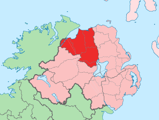
County Londonderry, also known as County Derry, is one of the six counties of Northern Ireland, one of the thirty-two counties of Ireland and one of the nine counties of Ulster. Before the partition of Ireland, it was one of the counties of the Kingdom of Ireland from 1613 onward and then of the United Kingdom after the Acts of Union 1800. Adjoining the north-west shore of Lough Neagh, the county covers an area of 2,118 km2 (818 sq mi) and today has a population of about 252,231.
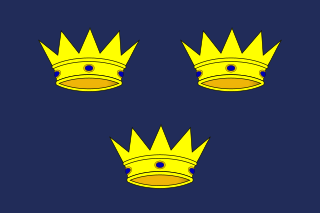
Munster is one of the four provinces of Ireland, located in the south of the island. In early Ireland, the Kingdom of Munster was one of the kingdoms of Gaelic Ireland ruled by a "king of over-kings". Following the Norman invasion of Ireland, the ancient kingdoms were shired into counties for administrative and judicial purposes. In later centuries, local government legislation has seen further sub-division of the historic counties.

Leinster is one of the four provinces of Ireland, situated in the southeast and east of Ireland.

County Tipperary is a county in Ireland. It is in the province of Munster and the Southern Region. The county is named after the town of Tipperary, and was established in the early 13th century, shortly after the Norman invasion of Ireland. It is Ireland's largest inland county and shares a border with eight counties, more than any other. The population of the county was 167,895 at the 2022 census. The largest towns are Clonmel, Nenagh and Thurles.
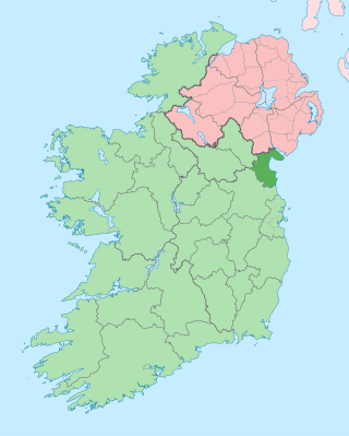
County Louth is a coastal county in the Eastern and Midland Region of Ireland, within the province of Leinster. Louth is bordered by the counties of Meath to the south, Monaghan to the west, Armagh to the north and Down to the north-east, across Carlingford Lough. It is the smallest county in Ireland by land area and the 17th most populous, with just over 139,100 residents as of 2022. The county is named after the village of Louth. Louth County Council is the local authority for the county.

Ennis is the county town of County Clare, in the mid-west of Ireland. The town lies on the River Fergus, north of where the river widens and enters the Shannon Estuary. Ennis is the largest town in County Clare, with a population of 27,923, making it the 6th largest town, and 11th largest urban settlement, as of the 2022 census. Dating from the 12th century the town's Irish name is short for Irish: Inis Cluana Rámhfhada, meaning "Island of the long rowing meadow", deriving from its location between two courses of the River Fergus.

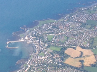
Portstewart is a small town in County Londonderry, Northern Ireland. It had a population of 7,854 people in the 2021 Census. It is a seaside resort neighbouring Portrush. Its harbour and scenic coastal paths form an Atlantic promenade leading to a two-miles beach, popular with holidaymakers in summer and surfers year-round.
Donaghadee is a small town in County Down, Northern Ireland. It lies on the northeast coast of the Ards Peninsula, about 18 miles (29 km) east of Belfast and about six miles (10 km) south east of Bangor. It is in the civil parish of Donaghadee and the historic barony of Ards Lower. It had a population of 6,869 people in the 2011 Census.

Kilkeel is a small town, civil parish and townland in County Down, Northern Ireland. It is the southernmost town in Northern Ireland. It lies within the historic barony of Mourne. Kilkeel town is the main fishing port on the Down coast, and its harbour is home to the largest fishing fleet in Northern Ireland. It had a population of 6,633 people at the 2021 census. The town contains the ruins of a 14th-century church and fort, winding streets and terraced shops. It lies just south of the Mourne Mountains.

Coalisland is a small town in County Tyrone, Northern Ireland, with a population of 5,682 in the 2011 Census. Four miles from Lough Neagh, it was formerly a centre for coal mining.

Lisdoonvarna is a spa town in County Clare in Ireland. The town is famous for its music and festivals. Although the music festival was discontinued in the 1980s, Lisdoonvarna still hosts its annual matchmaking festival each September. The population was 829 at the 2016 census.

Magherafelt is a town and civil parish in County Londonderry, Northern Ireland. It had a population of 9,071 at the 2021 Census. It is the biggest town in the south of the county and is the social, economic and political hub of the area. It is part of Mid-Ulster District.

Ballyjamesduff is a town in County Cavan, Ireland. A former market town, it was the winner of the 1966 and 1967 Irish Tidy Towns Competition.

Rathowen is a small village in County Westmeath, Ireland, on the N4 national primary route. Rathowen was designated as a census town by the Central Statistics Office for the first time in the 2016 census, at which time it had a population of 150 people. The population increased to 187 at the 2022 census.

Randalstown is a townland and small town in County Antrim, Northern Ireland, between Antrim and Toome. It has a very prominent disused railway viaduct and lies beside Lough Neagh and the Shane's Castle estate. The town is bypassed by the M22 motorway with junctions at both the eastern and western ends of the town. It had a population of 5,151 people in the 2021 Census.

Carrickfergus is a barony in County Antrim, Northern Ireland. It is bounded on the south-east by Belfast Lough, and otherwise surrounded by the barony of Belfast Lower. It is coextensive with the civil parish of Carrickfergus or St Nicholas and corresponds to the former county of the town of Carrickfergus, a county corporate encompassing Carrickfergus town.