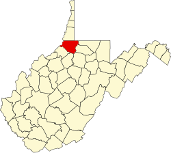
Littleton, West Virginia | |
---|---|
Census-designated place (CDP) | |
Location of Littleton, West Virginia | |
Coordinates: 39°42′5″N80°30′57″W / 39.70139°N 80.51583°W Coordinates: 39°42′5″N80°30′57″W / 39.70139°N 80.51583°W | |
Country | United States |
State | West Virginia |
County | Wetzel |
Area | |
• Total | 0.7 sq mi (1.7 km2) |
• Land | 0.7 sq mi (1.7 km2) |
• Water | 0.0 sq mi (0.0 km2) |
Elevation | 925 ft (282 m) |
Population | |
• Total | 198 |
• Density | 280/sq mi (120/km2) |
Time zone | UTC-5 (Eastern (EST)) |
• Summer (DST) | UTC-4 (EDT) |
ZIP code | 26581 |
Area code(s) | 304 |
FIPS code | 54-47788 [3] |
GNIS feature ID | 1542266 [4] |
Littleton is a census-designated place (CDP) in Wetzel County, West Virginia, United States. The population was 198 at the 2010 census. [2]
Some say the community derives its name from William Little, a pioneer settler, while others believe it was named after Harrison Little, a local reverend. [5] Littleton was formerly an incorporated town and was dissolved in 2004. [6]
Littleton is located at 39°42′5″N80°30′57″W / 39.70139°N 80.51583°W (39.701505, -80.515936). [1]
According to the United States Census Bureau, the town had a total area of 0.7 square miles (1.7 km2), all land.
As of the census [3] of 2000, there were 207 people, 73 households, and 48 families residing in the town. The population density was 1,149.1 inhabitants per square mile (444.0/km2). There were 98 housing units at an average density of 544.0 per square mile (210.2/km2). The racial makeup of the town was 96.62% White, and 3.38% from two or more races. Hispanic or Latino of any race were 0.48% of the population.
There were 73 households, out of which 37.0% had children under the age of 18 living with them, 37.0% were married couples living together, 16.4% had a female householder with no husband present, and 32.9% were non-families. 30.1% of all households were made up of individuals, and 16.4% had someone living alone who was 65 years of age or older. The average household size was 2.84 and the average family size was 3.41.
In the town the population was spread out, with 35.7% under the age of 18, 8.7% from 18 to 24, 26.6% from 25 to 44, 15.9% from 45 to 64, and 13.0% who were 65 years of age or older. The median age was 30 years. For every 100 females, there were 99.0 males. For every 100 females age 18 and over, there were 95.6 males.
The median income for a household in the town was $15,714, and the median income for a family was $15,469. Males had a median income of $20,417 versus $22,500 for females. The per capita income for the town was $6,036, which is the lowest in the state. About 52.7% of families and 64.6% of the population were below the poverty line, including 83.5% of those under the age of eighteen and 30.8% of those 65 or over.
Flatwoods is a town in Braxton County, West Virginia, United States, located approximately one mile from exit 67 of Interstate 79.
Anmoore is a town in Harrison County, West Virginia, United States. It is located at the intersection of WV 58 and Interstate 79. The population was 770 at the 2010 census.
Lumberport is a town in Harrison County, located in northern West Virginia, United States. The population was 876 at the 2010 census.
West Milford is a town in Harrison County, West Virginia, United States. The population was 630 at the 2010 census.
Jane Lew is a town in Lewis County, West Virginia, United States. The population was 409 at the time of the 2010 census.
Fairview is a town in Marion County, West Virginia, United States. The population was 408 at the 2010 census.
Farmington is a town in Marion County, West Virginia, United States. The population was 375 at the 2010 census. It is best known for being the site of the 1968 Farmington Mine disaster.
White Hall is a town in Marion County, West Virginia, United States. The population was 648 at the 2010 census. White Hall became incorporated in 1989. White Hall is right beside Fairmont and has many different stores and restaurants.
Worthington is a town in Marion County, West Virginia, United States. The population was 158 at the 2010 census. Worthington was incorporated in 1893 and named for Colonel George Worthington, an early settler. U.S. Route 19 passes through the town.
Blacksville is a town in Monongalia County, West Virginia, United States. The population was 171 at the 2010 census. It is included in the Morgantown, West Virginia Metropolitan Statistical Area.
Newburg is a town in Preston County, West Virginia, United States. The population was 329 at the 2010 census.
Auburn is a town in Ritchie County, West Virginia, United States. The population was 97 at the 2010 census.
Pennsboro is a city in Ritchie County, West Virginia, United States. The population was 1,171 at the 2010 census. The city is located at the junction of U.S. Route 50 and West Virginia Route 74; the North Bend Rail Trail also passes through the city.
Pullman is a town in Ritchie County, West Virginia, United States. The population was 154 at the 2010 census.
Flemington is a town in Taylor County, West Virginia, United States. The population was 312 at the 2010 census. Flemington was incorporated in 1922 by the West Virginia Circuit Court, and named for James Fleming, an early settler in the area originally from Hampshire County.
Middlebourne is a town in Tyler County, West Virginia, United States. The population was 815 at the 2010 census. It serves as the county seat of Tyler County.
Cowen is a town in Webster County, West Virginia, United States. The population was 541 at the 2010 census.
Pine Grove is a town in Wetzel County, West Virginia, United States. The population was 552 at the 2010 census. The community was named for a grove of pine trees near the original town site.
Smithfield is a town in Wetzel County, West Virginia, United States. The population was 145 at the 2010 census.
Paden City is a city in Tyler and Wetzel counties in the U.S. state of West Virginia, along the Ohio River. It was founded in 1902. The population was 2,633 at the 2010 census.