Los Angeles streets, 1-10

Last updated

This article covers streets in Los Angeles between and including 1st Street and 10th Street. Major streets have their own linked articles; minor streets are discussed here.

Los Angeles City in California

Los Angeles, officially the City of Los Angeles and often known by its initials L.A., is the most populous city in California, the second most populous city in the United States, after New York City, and the third most populous city in North America. With an estimated population of four million, Los Angeles is the cultural, financial, and commercial center of Southern California. The city is known for its Mediterranean climate, ethnic diversity, Hollywood and the entertainment industry, and its sprawling metropolis. Los Angeles is the largest city on the West Coast of North America.

Contents

These streets run parallel to each other, roughly east–west.

Streets change from west to east (for instance West 1st Street to East 1st Street) at Main Street.

Main Street (Los Angeles) major north-south thoroughfare in Los Angeles, California

Main Street is a major north-south thoroughfare in Los Angeles, California. It serves as the east-west postal divider for the city and the county as well.

All of these streets run through Downtown Los Angeles. In addition, many of the streets also run through Westlake and Boyle Heights.

Downtown Los Angeles Neighborhood of Los Angeles in Los Angeles, California

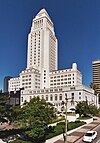
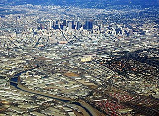
Downtown Los Angeles (DTLA) is the central business district of Los Angeles, California, as well as a diverse residential neighborhood of some 58,000 people. A 2013 study found that the district is home to over 500,000 jobs. It is also part of Central Los Angeles.

Westlake, Los Angeles Neighborhood of Los Angeles in California, United States of America

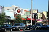
Westlake is a residential and commercial neighborhood in Central Los Angeles, California. It was developed in the 1920s, but many of its elegant mansions have been turned into apartments, and many new multiple-occupancy buildings have been constructed.

Boyle Heights, Los Angeles Neighborhood of Los Angeles

Boyle Heights is a neighborhood of almost 100,000 residents east of Downtown Los Angeles in the City of Los Angeles, California. The district has more than 20 public schools and 10 private schools.

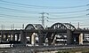
1st, 4th, 6th/Whittier, 7th, and Olympic have crossings over the Los Angeles River; the others do not.

Sixth Street Viaduct Bridge in Los Angeles, CA, US

The Sixth Street Viaduct, also known as the Sixth Street Bridge, was a viaduct bridge that connected the Arts District in Downtown Los Angeles with the Boyle Heights neighborhood. It spanned the Los Angeles River, the Santa Ana Freeway, and the Golden State Freeway (I-5), as well as Metrolink and Union Pacific railroad tracks and several local streets. Built in 1932, the viaduct was composed of three independent structures: the reinforced concrete west segment, the central steel arch segment over the river, and the reinforced concrete east segment. Over the years, the structure itself, surrounding areas, and the concrete banks of the Los Angeles River, became eyesores from years of residents vandalizing the area with graffiti, trash, human waste, and homeless encampments. In 1986, the Caltrans bridge survey found the Sixth Street Viaduct eligible for inclusion in the National Register of Historic Places.

Los Angeles River river in California that was the primary source of fresh water for the city but suffers pollution from agricultural and urban runoff.

The Los Angeles River starts in the Simi Hills and Santa Susana Mountains and flows through Los Angeles County, California, from Canoga Park in the western end of the San Fernando Valley, nearly 51 miles (82 km) southeast to its mouth in Long Beach. Several tributaries join the once free-flowing and frequently flooding river, forming alluvial flood plains along its banks. It now flows through a concrete channel on a fixed course, which was built after a series of devastating floods in the early 20th century.

Details

Streets

StreetWestEast# of lanesTraffic directionAdditional notesImage
1st Street North Croft Avenue Atlantic Boulevard
(Monterey Park)
2-6two-way Regional Connector Los Angeles City Hall (color) edit1.jpg
2nd StreetSouth Martel AvenueSouth Dangler Avenue
(East LA)
2two-way 2nd Street Tunnel
Regional Connector
Weller Court LA.jpg
3rd Street Alpine Drive
(Beverly Hills)
Woods Avenue
(East LA)
2-4westbound (Downtown)
two-way (elsewhere)
Third Street Los Angeles.jpg
4th Street South La Cienega Boulevard Hillview Avenue
(East LA)
2-4eastbound (Downtown)
two-way (elsewhere)
Subway Terminal Building.jpg
5th Street San Vicente Boulevard South McDonnell Avenue
(East LA)
2-4westbound (Downtown)
two-way (elsewhere)
Pershingsquare.jpg
6th Street San Vicente Boulevard
Saint Louis Avenue
Sixth Street Viaduct
Harding Avenue
(East LA)
2-4eastbound (Downtown)
two-way (elsewhere)
see also Whittier Boulevard Sixth Street Bridge over Los Angeles River.jpg
7th StreetSouth Norton AvenueSouth Indiana Street2-4two-way Macarthur Park.jpg
8th Street San Vicente Boulevard Olympic Boulevard 2-4westbound (Downtown)
two-way (elsewhere)
James M. Wood Boulevard
(9th Street)
Hauser BoulevardGladys Avenue2-4eastbound (Downtown)
two-way (elsewhere)
see also Olympic Boulevard
Olympic Boulevard
(10th Street)
5th Street
(Santa Monica)
Tobias Avenue
(Pico Rivera)
2-4two-way Tenth Street School.jpg

Related Research Articles

Transportation in Los Angeles complex multimodal regional, national and international hub for passenger and freight traffic

Los Angeles has a complex multimodal transportation infrastructure, which serves as a regional, national and international hub for passenger and freight traffic. The system includes the United States' largest port complex; an extensive freight and passenger rail infrastructure, including light rail lines and subway lines; numerous airports and bus lines; Transportation Network Companies; and an extensive freeway and road system. People in Los Angeles rely on cars as the dominant mode of transportation, but starting in 1990 Los Angeles Metro Rail has built over one hundred miles (160 km) of light and heavy rail serving more and more parts of Los Angeles.

Gold Line (Los Angeles Metro)

The Gold Line is a 31-mile (50 km) light rail line running from Azusa to East Los Angeles via Downtown Los Angeles serving several attractions, including Little Tokyo, Union Station, the Southwest Museum, Chinatown and the shops of Old Pasadena. The line, which is one of six in the Metro Rail system, entered service in 2003 and is operated by the Los Angeles County Metropolitan Transportation Authority (Metro). The Gold Line serves 27 stations.

Mid-Wilshire, Los Angeles Neighborhood of Los Angeles in California, United States

Mid-Wilshire is a neighborhood in the central region of Los Angeles, California. It is known for the Los Angeles County Museum of Art, the Petersen Automotive Museum, and the Miracle Mile shopping district.

Broadway (Los Angeles)

Broadway is a major thoroughfare in central Los Angeles and Los Angeles County, southern California. The Broadway Theater District in Downtown Los Angeles is the first and largest historic theater and cinema district listed on the National Register of Historic Places.

The Imperial Highway is a west-east thoroughfare in the counties of Los Angeles, Orange, San Diego, and Imperial in California. The main portion of the existing route begins at Vista Del Mar in Los Angeles near the Los Angeles International Airport and ends at the Anaheim - Orange line at Via Escola where it becomes Cannon Street. Formerly, the Route used to extend from Vista Del Mar to Calexico, where a portion of the highway still exists, but the Route was replaced with other highways, rendering the older portions of the Imperial Highway to fall out of use.

Olympic Boulevard (Los Angeles) road in Los Angeles, California

Olympic Boulevard is a major arterial road in Los Angeles, California. It stretches from Ocean Avenue on the western end of Santa Monica to East Los Angeles—farther than Wilshire Boulevard and most other streets.

Western Avenue (Los Angeles)

Western Avenue is a major four-lane street in the city of Los Angeles and through the center portion of Los Angeles County, California. It is one of the longest north–south streets in Los Angeles city and county, apart from Sepulveda Boulevard. It is about 29 miles (47 km) long. The avenue is known for prostitution, primarily between Melrose Avenue and 2nd Street.

3rd Street, Los Angeles

3rd Street in Los Angeles is a major east–west thoroughfare. The west end is in downtown Beverly Hills by Santa Monica Boulevard, and the east is at Alameda Street in downtown Los Angeles, where it shares a one-way couplet with 4th Street. East of Alameda it becomes 4th Street, where it heads to East Los Angeles, where it turns back into 3rd Street upon crossing Indiana Street. 3rd Street eventually becomes Pomona Boulevard in Monterey Park, where it then turns into Potrero Grande Drive and finally turns into Rush Street in Rosemead and ends in El Monte.

Purple Line (Los Angeles Metro) subway line in Los Angeles, operated by LACMTA

The Purple Line is a heavy rail subway line operating in Los Angeles, running between downtown and the Mid-Wilshire/Koreatown districts. It is one of six lines on the Metro Rail System, operated by the Los Angeles County Metropolitan Transportation Authority.

Regional Connector

The Regional Connector Transit Corridor is a light rail tunnel connection currently being built through Downtown Los Angeles to connect the current Metro Rail Blue and Expo Lines to the current Gold Line and Union Station. When completed, the project will provide a one-seat ride into the core of Downtown LA for passengers on these lines who currently need to transfer, and will reduce or eliminate transfers for many passengers traveling across the region via downtown.

Century Boulevard is a street in South Los Angeles, extending from Alameda Street in the east to the passenger terminals at Los Angeles International Airport in the west.

Temple Street (Los Angeles) street in Los Angeles, United States

Temple Street is a street in the City of Los Angeles, California. The street is an east-west thoroughfare that runs through Downtown Los Angeles parallel to the Hollywood Freeway between Virgil Avenue past Alameda Street to the banks of the Los Angeles River. It was developed as a simple one-block long lane by Jonathan Temple, a mid-19th Century Los Angeles cattle rancher and merchant.

1st Street, Los Angeles

1st Street is an east–west thoroughfare in Los Angeles and Monterey Park, California. It serves as a postal divider between north and south and is one of a few streets to run across the Los Angeles River. Though it serves as a major road east of downtown Los Angeles, it is a mostly residential street to the west.

This article covers streets in Los Angeles, California between and including 11th Street and 40th Street. Major streets have their own linked articles; minor streets are discussed here.

This article covers streets in Los Angeles, California between and including 41st Street and 250th Street. Major streets have their own linked articles; minor streets are discussed here.

The Los Angeles Avenues refer to a series of 50 numbered streets in Los Angeles, California in the Northeast and Eastside regions. They are all designated with the word "Avenue" followed by a number such as "Avenue 64." The Avenues are located in the Los Angeles neighborhoods of Lincoln Heights, Cypress Park, Montecito Heights, Glassell Park, Highland Park,Mt. Washington and Eagle Rock. They are not related to 2nd through 13th Avenues west of Arlington Street in Jefferson Park.

J (Los Angeles Railway) Los Angeles Railway line

J was a line operated by the Los Angeles Railway from 1911 to 1945, by Los Angeles Transit Lines from 1945 to 1958, and by the Los Angeles Metropolitan Transit Authority from 1958 to 1963

Los Angeles City Council District 8 is one of the 15 districts of the Los Angeles City Council, representing much of western South Los Angeles.

References

    See also