
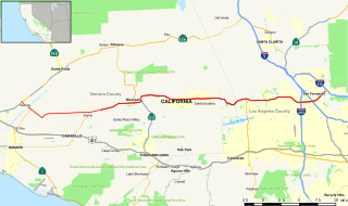
State Route 91 (SR 91) is a major east–west state highway in the U.S. state of California that serves several regions of the Greater Los Angeles urban area. A freeway throughout its entire length, it officially runs from Vermont Avenue in Gardena, just west of the junction with the Harbor Freeway, east to Riverside at the junction with the Pomona and Moreno Valley freeways.

State Route 133 is a state highway in the U.S. state of California, serving as an urban route in Orange County. It connects SR 1 in Laguna Beach through the San Joaquin Hills with several freeways in Irvine, ending at the SR 241, a toll road in the latter city. It is built as an expressway from SR 73 to Laguna Canyon Road, and past this, SR 133 is a freeway to I-5, and a tollway to SR 241 near the Santa Ana Mountains.
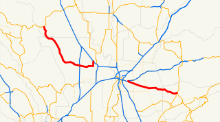
State Route 57 (SR 57), also known as the Orange Freeway for most of its length, is a north–south state highway in the Greater Los Angeles Area of California. It connects the interchange of Interstate 5 (I-5) and SR 22 near downtown Orange, locally known as the Orange Crush, to the Glendora Curve interchange with I-210 and SR 210 in Glendora. The highway provides a route across several spurs of the Peninsular Ranges, linking the Los Angeles Basin with the Pomona Valley and San Gabriel Valley.

State Route 111 is a state highway in the U.S. state of California. It is the main north-south route and retail corridor through the Coachella Valley, a part of the Colorado Desert in the southeastern corner of the state and a famous resort destination. It also runs through the Imperial Valley, and along the eastern shore of the Salton Sea. Its southern terminus is at the U.S.-Mexico border crossing in Calexico, and its northern terminus is at Interstate 10 at Whitewater.

State Route 160 is a state highway in the U.S. state of California consisting of two sections. The longer, southern, section is a scenic highway through the alluvial plain of the Sacramento River, linking SR 4 in Antioch with Sacramento via the Antioch Bridge. The northern section, separated from the southern by Sacramento city streets, is the North Sacramento Freeway, running from the 16th Street Bridge over the American River to Interstate 80 Business towards Roseville.

State Route 38 is a mostly rural and scenic state highway in the U.S. state of California, connecting Interstate 10 in Redlands with State Route 18 in the Big Bear Lake area. It is one of the primary routes into the San Bernardino Mountains. Despite the orientation of its alignment, SR 38 is assigned in a west–east direction.
State Route 2 (SR 2) is a state highway in the U.S. state of California that runs from the Los Angeles Basin and through the San Gabriel Mountains to the edge of the Victor Valley in the Mojave Desert. Officially, it begins at the intersection of Centinela Avenue in the City of Los Angeles limits adjacent to the city of Santa Monica and extends all the way to SR 138 east of Wrightwood. The highway currently is divided into three segments, and it briefly runs concurrently with U.S. Route 101 (US 101) and Interstate 210 (I-210) to connect the segments. The western section of the highway is an old routing of US 66; the eastern portion is known as the Angeles Crest Highway, while the middle section is known as the Glendale Freeway along with multiple surface streets around US 101.
State Route 118 is a state highway in the U.S. state of California that runs west to east through Ventura and Los Angeles counties. It travels from State Route 126 at the eastern edge of Ventura immediately northwest of Saticoy, then through Saticoy, in Ventura County east to Interstate 210 near Lake View Terrace in Los Angeles. SR 118 crosses the Santa Susana Pass and the northern rim of the San Fernando Valley along its route.

State Route 39 is a state highway in the U.S. state of California that travels through Orange and Los Angeles counties. Its southern terminus is at Pacific Coast Highway, in Huntington Beach. SR 39's northern terminus is at Islip Saddle on Angeles Crest Highway in the Angeles National Forest, but its northernmost 4.5-mile (7.2 km) segment has been closed to the public since 1978 due to a massive mud and rockslide. The repairs would cost a total or $100 million USD to repair the road. A portion of SR 39 from Stanton Avenue in Buena Park to Interstate 5 is now under the city of Buena Park's control, as Caltrans relinquished that portion in 2013. Since 2001, a portion of SR 39 that runs through the city of Stanton is being considered to be relinquished to the city. If so, the portion that runs through the city of Anaheim will still be state controlled.

State Route 243, or the Banning-Idyllwild Panoramic Highway, is a 30-mile two-lane state highway in the U.S. state of California that runs from Banning to Idyllwild in Riverside County. The highway is a connector between Interstate 10 (I-10) and SR 74. Along its route, it provides access to the San Bernardino National Forest. A road from Banning to Idyllwild was planned around the turn of the twentieth century, and was open by 1910. The road was added to the state highway system in 1970.
State Route 16 is a state highway in the northern region of the U.S. state of California that runs from Route 20 in Colusa County to Route 49 just outside Plymouth in Amador County, primarily crossing the Sacramento Valley. Much of the route through the Sacramento area is unsigned as it runs on a concurrency with the I-5 and US 50 freeways.

State Route 154 is a state highway in the U.S. state of California that runs from Los Olivos to Santa Barbara, crossing the San Marcos Pass in the Santa Ynez Mountains. Before U.S. Route 101 was built through the Gaviota Pass, SR 154 was the main throughway to Santa Barbara and the tri city area including use as a stagecoach route in early years. After being replaced by US 101 as the primary route between the Santa Ynez Valley and Santa Barbara, SR 154 now serves as a scenic bypass.

State Route 19, also known as Lakewood Boulevard and Rosemead Boulevard, is a state highway in the Los Angeles area of the U.S. state of California. The route is a north–south four-to-six lane suburban roadway, lying between the Long Beach Freeway (I-710) and San Gabriel River Freeway (I-605), and connecting the eastern parts of Long Beach and Pasadena via the Whittier Narrows. Since 1998, several pieces have been relinquished to local governments, and more transfers are authorized by state law. The portion of SR 19 north of the Whittier Narrows is officially State Route 164, once planned to be upgraded as the Rio Hondo Freeway, but has always been signed as part of SR 19.

State Route 66 is a state highway in the U.S. state of California that runs along a section of old U.S. Route 66 in Los Angeles and San Bernardino counties. It goes from State Route 210 in La Verne east to Interstate 215 in San Bernardino, passing through Claremont, Upland, Rancho Cucamonga, Fontana and Rialto along Foothill Boulevard. In San Bernardino, it is the part of Fifth Street west of H Street.

State Route 142, also known as Carbon Canyon Road for most of its length, is a state highway in the U.S. state of California that connects Brea in Orange County with Chino Hills in San Bernardino County. The eastern portion of the route is known as Chino Hills Parkway.

State Route 198 is an east–west state highway in the U.S. state of California that runs from U.S. Route 101 south of King City to Sequoia National Park. It connects the California Central Coast to the mid–Central Valley through Hanford and Visalia, although the most developed portion is in the Central Valley itself. SR 198 intersects the major north–south routes in the Central Valley, including Interstate 5 (I-5), SR 33, and SR 99.

State Route 70 is a state highway in the U.S. state of California, connecting SR 99 north of Sacramento with U.S. Route 395 near Beckwourth Pass via the Feather River Canyon. Through the Feather River Canyon, from SR 149 to US 395, SR 70 is the Feather River Scenic Byway, a Forest Service Byway that parallels the ex-Western Pacific Railroad's Feather River Route.

State Route 115 is a state highway in the U.S. state of California. It runs in Imperial County from Interstate 8 (I-8) southeast of Holtville to SR 111 in Calipatria. The routing was added to the state highway system in 1933, and was constructed by 1934; SR 115 was officially designated in the 1964 state highway renumbering.

State Route 127 is a state highway in the U.S. state of California that connects Interstate 15 in Baker to Nevada State Route 373 at the Nevada state line, passing near the eastern boundary of Death Valley National Park. The entire length of the highway closely follows the central portion of the former Tonopah and Tidewater Railroad and loosely follows the Amargosa River.

State Route 187 is a state highway in the U.S. state of California that runs along Venice Boulevard in Los Angeles from Lincoln Boulevard in Venice to Interstate 10 in the South Robertson district.


