Details
44th Street
Vernon Ave| From | Central Avenue |
|---|
44th Street has been renamed Vernon Avenue, and is served by Metro Local: line 105 and Metro Rapid: line 705. One Metro Rail light rail station:

Metro Local is a bus service type in Los Angeles County operated by the Los Angeles County Metropolitan Transportation Authority (Metro). This retronym designation was placed to differentiate it from the Metro Rapid service. Metro Local buses cover both local, limited-stop, and shuttle bus services.

Metro Rapid is a local express bus service in Los Angeles County, California with bus rapid transit characteristics. It operates in mixed traffic environments and has fewer stops than the Metro Local service. The system is mainly operated by Metro. Two routes are operated by Big Blue Bus, one by Culver CityBus and one by Torrance Transit. The Rapid program speeds up travel time for passengers, complementing the Metro Local bus network operated by the Metro as well as other bus routes operated by smaller agencies.
79th Street
79th Street has been renamed Nadeau Street.
96th Street
96th Street is a secondary street in South Los Angeles. Portions of it are renamed "Colden Avenue". It is also the site of the future LAX people mover station on Aviation Blvd and 96 Street.

South Los Angeles is a region in southern Los Angeles County, California, and mostly lies within the city limits of Los Angeles, just south of downtown.

A people mover or automated people mover (APM) is a type of small scale automated guideway transit system. The term is generally used only to describe systems serving relatively small areas such as airports, downtown districts or theme parks.
108th Street
108th Street is a major street in South Los Angeles, and was formerly served by Line 119
135th Street
135th Street is a major street in Hawthorne and Rosewood; it runs from Aviation Boulevard to McKinley Avenue. It is served by portions of Line 209.
151st Street
151st Street has been renamed Compton Boulevard/Somerset Boulevard in the east and Marine Avenue in the west. Compton Boulevard/Somerset Boulevard carries Metro Local lines 51 and 127. Marine Avenue carries portions of Metro Local lines 126 and 215. Two Metro stations:
161st Street
161st Street has been renamed Alondra Boulevard, served by Metro Local line 128.
174th Street
174th Street has been renamed Artesia Boulevard. It is served by Metro Local lines 130 and 344; Line 130 runs between Redondo Beach and Los Cerritos Center and Line 344 runs between Artesia Transit Center and Hawthorne Boulevard. One Metro station:
223rd Street
223rd Street is a major street in Carson and Harbor Gateway. It runs from Western Avenue to Alameda Street, where it becomes Wardlow Road upon entrance to Long Beach. One Metro station:
250th Street
250th Street, a major residential street in the city of Lomita, becomes Lomita Boulevard just east of Walnut. It is served by Torrance Transit line 9.
266th Street
266th Street is the highest numbered street in the system.
This page is based on this
Wikipedia article Text is available under the
CC BY-SA 4.0 license; additional terms may apply.
Images, videos and audio are available under their respective licenses.
Crenshaw Boulevard is a principal north-south thoroughfare in Los Angeles, California that runs through Crenshaw and other neighborhoods along a 23-mile route in the west-central part of the city.
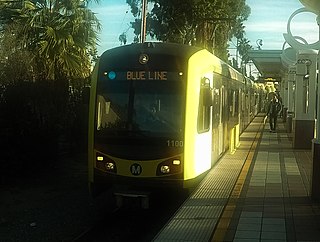
The Blue Line is a 22.0-mile (35.4 km) light rail line running north-south between Los Angeles and Long Beach, California, passing through Downtown Los Angeles, South Los Angeles, Watts, Willowbrook, Compton, Rancho Dominguez and Long Beach in Los Angeles County. It is one of six lines in the Metro Rail system. Opened in 1990, it is the system's oldest and third busiest line with an estimated 22.38 million boardings per year as of December 2017. It is operated by the Los Angeles County Metropolitan Transportation Authority.

Broadway is a major thoroughfare in central Los Angeles and Los Angeles County, southern California. The Broadway Theater District in Downtown Los Angeles is the first and largest historic theater and cinema district listed on the National Register of Historic Places.

Sepulveda Boulevard is a major street and transportation corridor in the City of Los Angeles and several other cities in western Los Angeles County, California. It is around 42.8 miles (68.9 km) in length, making it the longest street in the city and county of Los Angeles. The Boulevard is known as an area of prostitution.

Vermont Avenue is one of the longest running north/south streets in City of Los Angeles and Los Angeles County, California. With a length of 23.3 miles (37.5 km), is the third longest of the north/south thoroughfares in the region. For most of its length between its southern end in San Pedro and south of Downtown Los Angeles, it runs parallel to the west of the Harbor Freeway (I-110).

Artesia is an at grade light rail station on the Los Angeles County Metro Blue Line. It has an island platform, and is on the Blue Line right-of-way near Artesia Boulevard in the city of Compton, California. Artesia is a park and ride station with 380 parking spaces. The station is near the southern border of Compton, California near the unincorporated community of Rancho Dominguez. It is on Artesia Boulevard near the intersection of Alameda Street. It is also close to the Artesia Freeway(SR 91).

Atlantic Boulevard/Atlantic Avenue/Los Robles Avenue is a major north-south thoroughfare in eastern Los Angeles County, California.

Harbor Gateway Transit Center is a Metro Silver Line station and a large bus station at southern end of the Harbor Transitway located in the southwest corner of Interstate 110 and State Route 91 in Harbor Gateway close to Carson. The station has 12 bus bays and 900 park and ride spaces, and is the southern terminus of the Metro Silver Line. Many passengers connect to this station from other buses to transfer to the Silver Line. Public restrooms for passengers as began installation in October 2012 and opened in February 2013. The nextrip bus screens were installed in November 2012 and became fully functional in April 2013. The large hub is undergoing station improvements.
Artesia Boulevard is a west-east thoroughfare in the counties of Los Angeles and Orange.
Alameda Street is a north-south street in Los Angeles County, California. It is approximately 21 miles in length, running from Harry Bridges Boulevard in Wilmington; and through Carson, Compton, Lynwood, Watts, Vernon and Arts District to Spring and College in Chinatown. For much of its length, Alameda runs through present and former industrial corridors, and is paralleled by Southern Pacific Railway tracks.

Florence Avenue is a major east–west street in central Los Angeles County and South Los Angeles, in Southern California.
Long Beach Boulevard is a north–south thoroughfare in Los Angeles County.
This article covers streets in Los Angeles, California between and including 11th Street and 40th Street. Major streets have their own linked articles; minor streets are discussed here.

San Pedro Street is a major north-south thoroughfare in Los Angeles, California, running from Little Tokyo in Downtown Los Angeles to West Rancho Dominguez.
San Pedro Street was one of the earliest roadways, along with Alameda Street, between central Los Angeles and the Port of Los Angeles; much of the road's original alignment south of Jefferson Boulevard has been renamed Avalon Boulevard.
El Segundo Boulevard is a west-east thoroughfare in Los Angeles County. It has a total length of 11.9 miles. At one time, it was named "Ballona Avenue"
Dominguez Channel is a 15.7-mile-long (25.3 km) stream in southern Los Angeles County, California, that drains the Dominguez Watershed of 110 square miles (280 km2).

There are 9 routes assigned to the "N" zone of the California Route Marker Program, which designates county routes in California. The "N" zone includes county highways lying in Los Angeles and Orange counties.
