
Estes Park is a statutory town in Larimer County, Colorado, United States. A popular summer resort and the location of the headquarters for Rocky Mountain National Park, Estes Park lies along the Big Thompson River. Estes Park had a population of 5,858 at the 2010 census. Landmarks include The Stanley Hotel and The Baldpate Inn. The town overlooks Lake Estes and Olympus Dam.

Rocky Mountain National Park is an American national park located approximately 76 mi (122 km) northwest of Denver International Airport in north-central Colorado, within the Front Range of the Rocky Mountains. The park is situated between the towns of Estes Park to the east and Grand Lake to the west. The eastern and western slopes of the Continental Divide run directly through the center of the park with the headwaters of the Colorado River located in the park's northwestern region. The main features of the park include mountains, alpine lakes and a wide variety of wildlife within various climates and environments, from wooded forests to mountain tundra.

Middle Park is a high basin in the Rocky Mountains of north-central Colorado in the United States. It is located in Grand County, on the southwest slope of Rocky Mountain National Park, approximately 50 miles (80 km) west of Boulder.

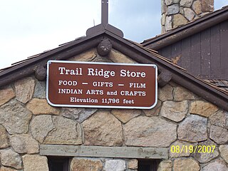
Rocky Mountain National Park's Alpine Visitor Center is located at 11,796 feet above sea level at Fall River Pass, one mile west of the highest point on Trail Ridge Road and four miles east of the Continental Divide at Milner Pass in the U.S. state of Colorado. It is the highest visitor center in the National Park System.

The Never Summer Mountains are a mountain range in the Rocky Mountains in north central Colorado in the United States consisting of seventeen named peaks. The range is located along the northwest border of Rocky Mountain National Park, forming the continental divide between the headwaters of the Colorado River in Rocky Mountain National Park to the local-east and the upper basin of the North Platte River to the local-west; the continental divide makes a loop in these mountains. The range is small and tall, covering only 25 sq mi (65 km2) with a north-south length of 10 mi (16 km) while rising to over 12,000 ft (3,700 m) at over ten distinct peaks. The range straddles the Jackson-Grand county line for most of its length, and stretches into Jackson and Larimer county at its northern end. A panoramic view of the range is available from sections of Trail Ridge Road in Rocky Mountain National Park. One of the northernmost peaks, Nokhu Crags, is prominently visible from the west side of Cameron Pass.

Lawn Lake Dam was an earthen dam in Rocky Mountain National Park, United States that failed on July 15, 1982, at about 6 a.m., in an event known as the flood of 1982. The sudden release of 30 million cubic feet of water resulted in a flash flood that killed three people camping in the park and caused $31 million in damage to the town of Estes Park, Colorado and other downstream areas.

Froggatt Edge is a gritstone escarpment in the Dark Peak area of the Peak District National Park, in Derbyshire, England, close to the villages of Froggatt, Calver, Curbar, Baslow and Grindleford. The name Froggatt Edge applies only to the northernmost section of the escarpment; the middle and southernmost sections are called Curbar Edge and Baslow Edge respectively. The escarpment, like many in this area, is easily accessible from Sheffield.

The Colorado-Big Thompson Project is a federal water diversion project in Colorado designed to collect West Slope mountain water from the headwaters of the Colorado River and divert it to Colorado's Front Range and plains. In Colorado, approximately 80% of the state's precipitation falls on the West Slope, in the Rocky Mountains, while around 80% of the state's growing population lives along the East Slope, between the cities of Fort Collins and Pueblo.
Meziadin Lake Provincial Park is a provincial park in British Columbia, Canada. It sits 40 miles (64 km) east of Stewart, British Columbia; inland from the Bear Pass. A beautiful mountain lake, surrounded by forest, it is also defined to the west by a ridge a tall mountains of the Coast Range. There are campsites, a beach and ample fish in the lake.
Fall River Pass is a mountain pass in northern Colorado, in the Rocky Mountains of the western United States. It is located in the Front Range, within Rocky Mountain National Park. The pass is traversed by U.S. Highway 34 on Trail Ridge Road between Granby and Estes Park. However, as at Milner Pass on the Continental Divide, the road does not descend after reaching the pass from the west, but instead continues to climb along a side ridge; thus, neither pass is the high point on Trail Ridge Road, which crests at 12,183 feet (3,713 m) elevation, east of Fall River Pass, still within Rocky Mountain National Park. On the other hand, the old, largely unpaved, and one-way-uphill Fall River Road does have its summit at Fall River Pass, where it joins the modern highway for the descent to the west.
The High Rockies, or high country, is a term for a region of the U.S. state of Colorado. It commonly includes Larimer County, Jackson County, Routt County, Grand County, Summit County, Eagle County, Lake County, and Pitkin County. Some notable towns there include Estes Park, Walden, Steamboat Springs, Grand Lake, Winter Park, Breckenridge, Dillon, Vail, Leadville, and Aspen. The geography of the High Rockies has some of the most rugged parts of the Rocky Mountains and consists of the Front Range and mountainous topography to the west, much of which is on or near the Continental Divide. Known for pine forests and winding roads, the former mining towns there have been reinvented by wilderness tourism such as hiking, cycling, fishing, and most especially both cross-country and alpine skiing. Notable ski resorts include Copper Mountain, Keystone Resort, Steamboat Ski Resort, Beaver Creek Resort, Buttermilk, Aspen Highlands, Snowmass, and Aspen Mountain. The High Rockies are also the location of Rocky Mountain National Park and Arapaho National Forest.

Cwm Idwal is a cirque in the Glyderau range of mountains in northern Snowdonia, the national park in the mountainous region of North Wales. Its main interest is to hill walkers and rock climbers, but it is also of interest to geologists and naturalists, given its combination of altitude, aspect (north-facing) and terrain. In a 2005 poll conducted by Radio Times, Cwm Idwal was ranked the 7th greatest natural wonder in Britain.

Drake is an unincorporated community in Larimer County, Colorado located in the Big Thompson Canyon between Estes Park, Colorado and Loveland, Colorado near Rocky Mountain National Park. A U.S. Post Office is also situated in the county ZIP Code 80515. The 2010 population of Drake was 1,010. The last birth of a child in Drake occurred on the upper floor of the Old Horse Stall Building; June 10, 2001.

Glen Haven is an unincorporated community and a U.S. Post Office in Larimer County, Colorado, United States. The Glen Haven Post Office has the ZIP Code 80532.
Beth Rodden is an American rock climber known for her ascents of hard single pitch trad routes. She was the youngest woman to climb 5.14a (8b+), and is one of the only women in the world to have redpointed a 5.14c (8c+) traditional climb. Rodden and fellow climber Tommy Caldwell were partners from 2000 to 2010, during which time they completed the second free ascent of The Nose, and Rodden made the first ascent of Meltdown, one of the hardest traditional climbs in the world.
KGRE-FM is a commercial radio station located in Estes Park, Colorado, broadcasting to the Fort Collins, Colorado area on 102.1 FM. KGRE-FM airs a Regional Mexican music format branded as El Tigre, simulcasting KGRE 1450 AM Greeley, Colorado.
History of Rocky Mountain National Park began when Paleo-Indians traveled along what is now Trail Ridge Road to hunt and forage for food. Ute and Arapaho people subsequently hunted and camped in the area. In 1820, the Long Expedition, led by Stephen H. Long for whom Longs Peak was named, approached the Rockies via the Platte River. Settlers began arriving in the mid-1800s, displacing the Native Americans who mostly left the area voluntarily by 1860, while others were removed to reservations by 1878.

Horseshoe Park is a flat at 8,524 feet (2,598 m) in elevation in Larimer County, Colorado. It is within the Rocky Mountain National Park, which lies between Estes Park to the east and Grand Lake, Colorado on the west. Horseshoe Park is home to bighorn sheep, elk and other wildlife, and it is a wetland sanctuary for wide variety of birds. Recreational activities include picnicking, hiking, cross-country skiing and snowshoeing. Roaring River, Lawn Lake and Crystal Lake are located here.

Upper Beaver Meadows is a montane meadow and visitor attraction in Rocky Mountain National Park in Colorado. The area is known as a good bird-watching spot and its trail leads to a number of other trails within the park. The trails may be used for hiking, snowshoeing, or cross-country skiing.
