
Longs Peak is a high and prominent mountain in the northern Front Range of the Rocky Mountains of North America. The 14,259-foot (4346 m) fourteener is located in the Rocky Mountain National Park Wilderness, 9.6 miles (15.5 km) southwest by south of the Town of Estes Park, Colorado, United States. Longs Peak is the northernmost fourteener in the Rocky Mountains of Colorado and the highest point in Boulder County and Rocky Mountain National Park. The mountain was named in honor of explorer Stephen Harriman Long and is featured on the Colorado state quarter.

Hans Florine is an American rock climber, who holds the record for the number of ascents of Yosemite Valleys El Capitan and is known for holding the speed record on The Nose of Yosemite’s El Capitan 8 different times. Hans' last speed record on The Nose was accomplished with Alex Honnold for climbing The Nose in 2:23:46, on June 17, 2012. In addition to climbing El Capitan over 175 times, Hans also holds the record for the number of ascents of The Nose climbing it more than 111 times.

Delaware Water Gap is a water gap on the border of the U.S. states of New Jersey and Pennsylvania where the Delaware River cuts through a large ridge of the Appalachian Mountains.

Sport climbing is a type of free climbing in rock climbing where the lead climber clips into pre-drilled permanent bolts for their protection while ascending a route. Sport climbing differs from the riskier traditional climbing where the lead climber has to insert temporary protection equipment while ascending.
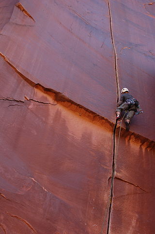
Rock climbing is a sport in which participants climb up, across, or down natural rock formations or indoor climbing walls. The goal is to reach the summit of a formation or the endpoint of a usually pre-defined route without falling. Rock climbing is a physically and mentally demanding sport, one that often tests a climber's strength, endurance, agility and balance along with mental control. Knowledge of proper climbing techniques and the use of specialized climbing equipment is crucial for the safe completion of routes.

Smith Rock State Park is a state park located in central Oregon's High Desert near the communities of Redmond and Terrebonne. The day-use area of the park is open daily from dawn to dusk. The park also has a camping area as well that accommodates tent camping only. Its sheer cliffs of tuff and basalt are ideal for rock climbing of all difficulty levels. Smith Rock is generally considered the birthplace of modern American sport climbing, and is host to cutting-edge climbing routes. It is popular for sport climbing, traditional climbing, multi-pitch climbing, and bouldering.

The Regular Northwest Face of Half Dome was the first Grade VI big wall climbing route in the United States. It was first climbed in 1957 by a team consisting of Royal Robbins, Mike Sherrick, and Jerry Gallwas. Its current aid climbing rating is VI 5.9 A1 or 5.12 for the free climbing variation. It is recognized in the historic climbing text Fifty Classic Climbs of North America and considered a classic around the world.

The Needles of the Black Hills of South Dakota are a region of eroded granite pillars, towers, and spires within Custer State Park. Popular with rock climbers and tourists alike, the Needles are accessed from the Needles Highway, which is a part of Sylvan Lake Road. The Cathedral Spires and Limber Pine Natural Area, a 637-acre (258 ha) portion of the Needles containing six ridges of pillars as well as a disjunct stand of limber pine, was designated a National Natural Landmark in 1976.

Competition climbing is a form of regulated rock climbing competition held indoors on purpose-built artificial climbing walls. The three standalone competition climbing disciplines are: lead climbing, bouldering, and speed climbing. A fourth discipline of "combined" is based on results in the three main disciplines. Competition climbing is sometimes called "sport climbing", which is the type of lead climbing performed in competition climbing.
John Long is an American rock climber and author. His stories have been translated into many languages.
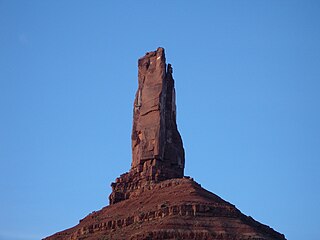
The Kor-Ingalls Route is a traditional rock climbing route located on Castleton Tower. Castleton Tower sits in Castle Valley North-East of Moab, Utah. The Route is recognized in the historic climbing text Fifty Classic Climbs of North America and considered a classic around the world.

The Salathé Wall is one of the original big wall climbing routes up El Capitan, a 3,000-foot (900 m) high granite monolith in Yosemite National Park. The Salathé Wall was named by Yvon Chouinard in honor of John Salathé, a pioneer of rock climbing in Yosemite. The route is recognized in the historic climbing text Fifty Classic Climbs of North America and is considered a classic around the world.

Fisher Towers are a series of towers made of Cutler sandstone capped with Moenkopi sandstone and caked with a stucco of red mud located near Moab, Utah. The Towers are named for a miner who lived near them in the 1880s. The Towers are world-renowned as a subject for photography and for its classic rock climbing routes.
The Diamond is the sheer and prominent east face of Longs Peak and named for the shape of the cliff. The face has a vertical gain of more than 900 feet (270 m) all above an elevation of 13,000 feet (4,000 m). It is a world-famous Alpine climb.
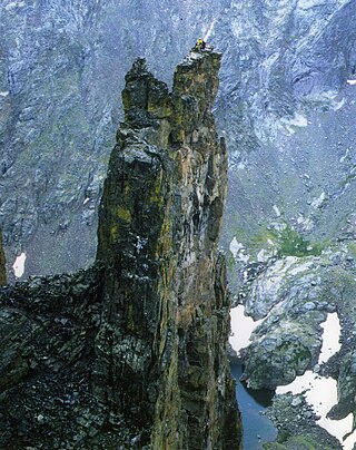
Petit Grepon is a semi-detached spire in Colorado's Rocky Mountain National Park. It is one of the "Cathedral Spires" which also includes: Sharkstooth, The Saber, and The Foil. The South Face route of Petit Grepon is described in the historic climbing text Fifty Classic Climbs of North America and considered a classic around the world.
The South Face of Petit Grepon is a popular technical climbing route on the Petit Grepon in Colorado's Rocky Mountain National Park. The South Face is recognized in the historic climbing text Fifty Classic Climbs of North America and considered a classic around the world.

Nelson Rocks is a large privately owned rock formation located in the North Fork Valley of Pendleton County, West Virginia, United States. The area is operated under the name of NROCKS Outdoor Adventures, and was previously known as Nelson Rocks Outdoor Center (NROC).
Poke-O-Moonshine Mountain, spelled Pokamoonshine on U.S. Geological Survey maps, and sometimes known as just Poke-O, is a minor peak of the Adirondack Mountains. The name is believed to be a corruption of the Algonquin words pohqui, meaning 'broken', and moosie, meaning 'smooth'. It is located in the town of Chesterfield, New York, United States, on New York state Forest Preserve land, part of the Taylor Pond Wild Forest complex within the Adirondack Park. Due to its location next to the pass through which most travelers from the north enter the range, it has been called the "gateway to the Adirondacks".
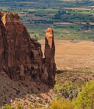
Sentinel Spire is a 5,500-foot-elevation (1,700-meter) sandstone pillar located in Colorado National Monument, in Mesa County of western Colorado, United States. This 200-foot freestanding tower is situated in Wedding Canyon, one-half mile east of the monument's visitor center, and 9 miles (14 km) west of the community of Grand Junction. It is also immediately south of Window Rock, and north of another climbing destination, Pipe Organ, both of which can be seen from viewpoints along Rim Rock Drive. The first ascent of the summit was made May 3, 1960, by Layton Kor, Harvey Carter, and John Auld via the class 5.10 route, Fast Draw. This was the day before the climbers also made the first ascent of nearby Kissing Couple. The first solo ascent was made by Ron Olevsky in March 1976, and the first free ascent was made by Andy Petefish and John Christenson in 1978. Some climbers refer to Sentinel Spire as Watusi Spear.
Coxcomb Peak is a 13,656-foot-elevation (4,162-meter) mountain summit located on the common boundary of Hinsdale County and Ouray County, in Colorado, United States. It is situated nine miles northeast of the community of Ouray, in the Uncompahgre Wilderness, on land managed by Uncompahgre National Forest. It is part of the San Juan Mountains which are a subset of the Rocky Mountains, and is situated west of the Continental Divide. Coxcomb ranks as the 171st-highest peak in Colorado, and topographic relief is significant as the south aspect rises 2,000 feet above Wetterhorn Basin in approximately one mile, and 4,400 feet above Cow Creek in three miles. Neighbors include Precipice Peak 2.7 miles to the north, Redcliff one-half mile north, Matterhorn Peak 2.3 miles to the east-southeast, and nearest higher neighbor Wetterhorn Peak 1.8 mile to the southeast. The mountain's descriptive name, which has been officially adopted by the United States Board on Geographic Names, was in use since at least 1906 when Henry Gannett published it in the Gazetteer of Colorado.
