
St. Vrain Creek is a tributary of the South Platte River, approximately 32.2 miles (51.8 km) long, in north central Colorado in the United States. It drains part of the foothills north of Boulder and the Colorado Piedmont area in the vicinity of Longmont.
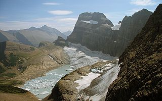
Gem Glacier is the smallest named glacier in Glacier National Park (U.S.). Located on the east side of the Continental Divide arête known as the Garden Wall, the glacier is situated on the cliff face above the better known Grinnell Glacier. Gem Glacier is a hanging glacier, and drapes down from the north face of the steep arete to which it is attached. Gem Glacier is only 5 acres (0.020 km2) in area and is far below the 25 acres (0.10 km2) threshold often cited as qualifying as an active glacier. Between 1966 and 2005, Gem Glacier lost 30 percent of its acreage and Grinnell Glacier lost 40 percent.

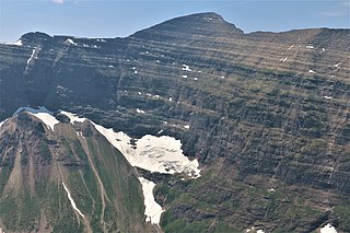
Swiftcurrent Glacier is in Glacier National Park in the U.S. state of Montana.The glacier is on the east side of the Continental Divide arête known as the Garden Wall. Swiftcurrent Glacier is one of several glaciers that are being monitored to determine stream flow alterations that occur due to glacial retreat. Compared to other glaciers in Glacier National Park, Swiftcurrent Glacier has experienced relatively slow retreat. As of 2005, the glacier had an area of 55 acres (0.22 km2), a 14 percent reduction since 1966.

Tyndall Glacier is a small cirque glacier in Rocky Mountain National Park in the U.S. state of Colorado. Tyndall Glacier is on the east side of the Continental Divide and in a cirque to the north of Hallett Peak. Tyndall Glacier is both an ice and a rock glacier, with the lower portions of the glacier being composed primarily of rock debris and a small portion of ice.

Stanton Glacier is a glacier in Flathead National Forest in the U.S. state of Montana. The glacier is situated in a cirque on the northeast slope of Great Northern Mountain. Stanton Glacier is one of several glaciers that have been selected for monitoring by the U.S. Geological Survey's Glacier Monitoring Research program, which is researching changes to the mass balance of glaciers in and surrounding Glacier National Park (U.S.). Stanton Glacier is 1 mile (1.6 km) northwest of Grant Glacier.
Andrews Glacier is an alpine glacier in a cirque below Otis Peak in Rocky Mountain National Park in the U.S. state of Colorado. The glacier extends from Andrews Pass at nearly 12,000 to 11,700 feet with some perennial snow extending to Andrews Tarn, a small proglacial lake. When images of the glacier taken in the early 1900s are compared with those of the early 2000s, Andrews Glacier is showing a negative glacier mass balance which indicates the glacier is retreating.

Chaney Glacier is in Glacier National Park in the U.S. state of Montana. The glacier is situated in a cirque to the southeast of Mount Kipp on the eastern side of the Continental Divide. Chaney Glacier is one of several glaciers that have been selected for monitoring by the U.S. Geological Survey's Glacier Monitoring Research program, which is researching changes to the mass balance of glaciers in and surrounding Glacier National Park. The glacier is being monitored using remote sensing equipment and repeat photography, where images of the glacier are taken from identical locations periodically.
Agassiz Glacier is in Glacier National Park in the U.S. state of Montana. It is named after Louis Agassiz, a Swiss-American glaciologist. The glacier is situated in a cirque to the southeast of Kintla Peak west of the Continental Divide. Agassiz Glacier is one of several glaciers that have been selected for monitoring by the U.S. Geological Survey's Glacier Monitoring Research program, which is researching changes to the mass balance of glaciers in and surrounding Glacier National Park.

Saint Mary's Glacier is a semi-permanent snowfield located in Arapaho National Forest in the U.S. state of Colorado. Saint Mary's Glacier is 2.5 mi (4.0 km) southeast of James Peak. The nearest community is the unincorporated Alice, Colorado and is accessible via a 1.5 mile hike from a parking lot in Alice.
Lupfer Glacier is in Glacier National Park in the U.S. state of Montana. The glacier is situated immediately to the east of Mount Phillips at an elevation between 6,500 ft (2,000 m) and 6,000 ft (1,800 m) above sea level. Lupfer Glacier covers an area of approximately 16 acres (0.065 km2) and does not meet the threshold of 25 acres (0.10 km2) often cited as being the minimum size to qualify as an active glacier. Between 1966 and 2005 Lupfer Glacier lost over 50 percent of its surface area.
Fissure Glacier is located in the U.S. state of Montana. The glacier is situated east of Lowary Peak in the Mission Range.
Fair Glacier is an alpine glacier located just west of Apache Peak, in Roosevelt National Forest in the U.S. state of Colorado. The glacier is immediately west of the Continental Divide on the opposite side of the divide from Isabelle Glacier.
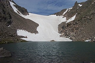
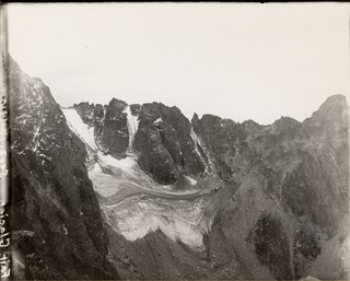
Isabelle Glacier is an alpine glacier located 0.28 mi (0.45 km) northeast of Apache Peak and 0.25 mi (0.40 km) southwest of Shoshoni Peak, in Roosevelt National Forest in the US state of Colorado. The glacier is immediately east of the Continental Divide on the opposite side of the divide from Fair Glacier. Isabelle Glacier is the source of the South Saint Vrain Creek and can be reach by trail and is a 8.4 mi (13.5 km) round-trip hike from the trailhead.
Mills Glacier is an alpine glacier near the base of the east mountain face of Longs Peak, in Rocky Mountain National Park in the U.S. state of Colorado.
Moomaw Glacier is an alpine glacier in Rocky Mountain National Park in the U.S. state of Colorado. Moomaw Glacier is almost 1 mi (1.6 km) northeast of Isolation Peak and the old terminal moraine of the glacier impounds Frigid Lake.
Peck Glacier is an alpine glacier in Roosevelt National Forest in the U.S. state of Colorado. Peck Glacier is .50 mi (0.80 km) northwest of Fair Glacier.
Rowe Glacier is an alpine glacier in Rocky Mountain National Park in the U.S. state of Colorado. It is 300 yd (270 m) north of Hagues Peak and the source of the North Fork Big Thompson River. Rowe Glacier was the first glacier to be identified in Colorado.
Taylor Glacier is a small cirque glacier in Rocky Mountain National Park in the U.S. state of Colorado. Taylor Glacier is on the east side of the Continental Divide and adjacent to Taylor Peak. Taylor Glacier is both an ice and a rock glacier, with the lower portions of the glacier being composed primarily of rock debris and a small portion of ice.
The Dove is a small cirque glacier or perennial snowfield located in Rocky Mountain National Park in the U.S. state of Colorado. The Dove is on the north slope of Longs Peak and near The Keyhole, which is along a popular climbing route to the summit.
Saint Vrains is a ghost town in Weld County, Colorado, United States.
