
Cedar Breaks National Monument is a U.S. National Monument located in the U.S. state of Utah near Cedar City. Cedar Breaks is a natural amphitheater, stretching across 3 miles (4.8 km), with a depth of over 2,000 feet (610 m). The elevation of the rim of the amphitheater is over 10,000 feet (3,000 m) above sea level. Rising above the rim is the prominent Brian Head, the peak of which lies a short distance outside of the National Monument boundary.

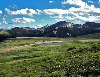
Rocky Mountain National Park is a national park of the United States located approximately 55 mi (89 km) northwest of Denver in north-central Colorado, within the Front Range of the Rocky Mountains. The park is situated between the towns of Estes Park to the east and Grand Lake to the west. The eastern and western slopes of the Continental Divide run directly through the center of the park with the headwaters of the Colorado River located in the park's northwestern region. The main features of the park include mountains, alpine lakes and a wide variety of wildlife within various climates and environments, from wooded forests to mountain tundra.

Sequoia National Park is a national park of the United States in the southern Sierra Nevada east of Visalia, California. The park was established on September 25, 1890, and today protects 404,064 acres of forested mountainous terrain. Encompassing a vertical relief of nearly 13,000 feet (4,000 m), the park contains the highest point in the contiguous United States, Mount Whitney, at 14,505 feet (4,421 m) above sea level. The park is south of, and contiguous with, Kings Canyon National Park; both parks are administered by the National Park Service together as Sequoia and Kings Canyon National Parks. UNESCO designated the areas as Sequoia-Kings Canyon Biosphere Reserve in 1976.

Trail Ridge Road is the name for the 48-mile (77 km) stretch of U.S. Highway 34 that traverses Rocky Mountain National Park from Estes Park, Colorado in the east to Grand Lake, Colorado in the west. Together with the connecting 6.9-mile (11 km) Beaver Meadow Road, Trail Ridge Road forms the 55-mile (89 km) Trail Ridge Road/Beaver Meadow National Scenic Byway, an All-American Road. With a high point at 12,183 feet (3,713 m) elevation, Trail Ridge Road is the highest continuous paved road in North America. The higher portion of Trail Ridge Road is closed from October to May.

Mount Blue Sky is the highest peak in the Mount Evans Wilderness in the Front Range of the Rocky Mountains of North America. The prominent 14,266.1-foot (4,348 m) fourteener is located 13.4 miles (21.6 km) southwest by south of Idaho Springs in Clear Creek County, Colorado, United States, on the drainage divide between Clear Creek in Arapaho National Forest and the North Fork South Platte River in Pike National Forest.

The San Francisco Peaks are a volcanic mountain range in the San Francisco volcanic field in north central Arizona, just north of Flagstaff and a remnant of the former San Francisco Mountain. The highest summit in the range, Humphreys Peak, is the highest point in the state of Arizona at 12,633 feet (3,851 m) in elevation. The San Francisco Peaks are the remains of an eroded stratovolcano. An aquifer within the caldera supplies much of Flagstaff's water while the mountain itself is in the Coconino National Forest, a popular recreation site. The Arizona Snowbowl ski area is on the western slopes of Humphreys Peak, and has been the subject of major controversy involving several tribes and environmental groups.

Walnut Canyon National Monument is a United States National Monument located about 10 mi (16 km) southeast of downtown Flagstaff, Arizona, near Interstate 40. The canyon rim elevation is 6,690 ft (2,040 m); the canyon's floor is 350 ft (110 m) lower. A 0.9 mi (1.4 km) long loop trail descends 185 ft (56 m) into the canyon passing 25 cliff dwelling rooms constructed by the Sinagua, a pre-Columbian cultural group that lived in Walnut Canyon from about 1100 to 1250 AD. Other contemporary habitations of the Sinagua people are preserved in the nearby Tuzigoot and Montezuma Castle national monuments.
Independence Pass, originally known as Hunter Pass, is a high mountain pass in central Colorado, United States. It is at elevation 12,095 ft (3,687 m) on the Continental Divide in the Sawatch Range of the Rocky Mountains. The pass is midway between Aspen and Twin Lakes, on the border between Pitkin and Lake counties.
The Powderhorn Wilderness is a 62,050-acre (251.1 km2) wilderness area in Hinsdale and Gunnison counties, Colorado, United States, located 5 miles (8.0 km) northeast of Lake City.

The Coconino National Forest is a 1.856-million acre United States National Forest located in northern Arizona in the vicinity of Flagstaff, with elevations ranging from 2,600 feet to the highest point in Arizona at 12,633 feet. Originally established in 1898 as the "San Francisco Mountains National Forest Reserve", the area was designated a U.S. National Forest by Pres. Theodore Roosevelt on July 2, 1908, when the San Francisco Mountains National Forest Reserve was merged with lands from other surrounding forest reserves to create the Coconino National Forest. Today, the Coconino National Forest contains diverse landscapes, including deserts, ponderosa pine forests, flatlands, mesas, alpine tundra, and ancient volcanic peaks.

Alpine Tunnel is a 1,772 ft (540 m) narrow gauge railroad tunnel located east of Pitkin, Colorado, on the former Denver, South Park and Pacific Railroad route from Denver to Gunnison. At an elevation of 11,523 feet (3,512 m), it was the first tunnel constructed across the Continental Divide in Colorado and was the highest railroad tunnel in North America at the time of its construction in 1882. The line was abandoned less than 30 years later, in 1910, after a series of accidents and problems in and around the tunnel. Now the tunnel is sealed, and the remaining trackbed serves as a trail for hikers and bicyclists.

The Weminuche Wilderness is a wilderness area in southwest Colorado managed by the United States Forest Service as part of the San Juan National Forest on the west side of the Continental Divide and the Rio Grande National Forest on the east side of the divide. The Weminuche Wilderness was designated by Congress in 1975, and expanded by the Colorado Wilderness Acts of 1980 and 1993. It is located 4 miles (6.4 km) southeast of the town of Silverton, 17 miles (27 km) northeast of Durango, and 8 miles (13 km) west of South Fork. At 499,771 acres (2,022.50 km2), it is the largest wilderness area in the state of Colorado. Elevation in the wilderness ranges from 7,700 feet (2,300 m) along the Animas River to 14,093 feet (4,296 m) at the summit of Windom Peak.

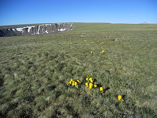
Summit Lake Park is a park located along Mount Blue Sky Scenic Byway about 64 miles (100 km) west of Denver, Colorado. The park is 160 acres (0.65 km2) in size and contains alpine tundra. Land to the east of the lake is in a state of permafrost which helps to prevent drainage of the area. During the summer, the park is filled with wildflowers, some of which have not been found anywhere else outside of the Arctic Circle. The park is named after Summit Lake, the headwaters of Bear Creek.

Arizona is a landlocked state situated in the southwestern region of the United States of America. It has a vast and diverse geography famous for its deep canyons, high- and low-elevation deserts, numerous natural rock formations, and volcanic mountain ranges. Arizona shares land borders with Utah to the north, the Mexican state of Sonora to the south, New Mexico to the east, and Nevada to the northwest, as well as water borders with California and the Mexican state of Baja California to the southwest along the Colorado River. Arizona is also one of the Four Corners states and is diagonally adjacent to Colorado.

The ecology of the Rocky Mountains is diverse due to the effects of a variety of environmental factors. The Rocky Mountains are the major mountain range in western North America, running from the far north of British Columbia in Canada to New Mexico in the southwestern United States, climbing from the Great Plains at or below 1,800 feet (550 m) to peaks of over 14,000 feet (4,300 m). Temperature and rainfall varies greatly also and thus the Rockies are home to a mixture of habitats including the alpine, subalpine and boreal habitats of the Northern Rocky Mountains in British Columbia and Alberta, the coniferous forests of Montana and Idaho, the wetlands and prairie where the Rockies meet the plains, a different mix of conifers on the Yellowstone Plateau in Wyoming, the montane forests of Utah, and in the high Rockies of Colorado and New Mexico, and finally the alpine tundra of the highest elevations.
Beatrice "Bettie" Willard was an American botanist who specialized in studies on the ecology and botany of high alpine tundra, as well as arctic tundra. Willard's studies influenced public policy with her studies, which centered on plant life at high altitudes. Willard was responsible for the establishment of the Beatrice Willard Alpine Tundra Research Plots above the treeline in Rocky Mountain National Park, now listed on the National Register of Historic Places. In later years she was an adviser to U.S. presidents Nixon and Ford as the first woman on the Council on Environmental Quality (CEQ).

Research Plot 2, located near Centennial Ave. and 18th St. N. on the North Dakota State University campus in Fargo, North Dakota. The plot was established in 1882 on land that was broken from native prairie sod. It has been sown to spring wheat continuously since that date. The plot was listed on the National Register of Historic Places in 1991 as Agricultural Research Site, but has historically been known as Research Plot 2.

Research Plot 30, is a historic agriculture site on the North Dakota State University campus in Fargo, North Dakota. When the pioneers broke up the grass prairie sod, flax was usually one of the first crops sown. If flax was sown continuously or with short rotations between subsequent flax crops, the flax became diseased and was called "flax sick" by farmers. The symptoms were wilting and dying flax plants during the growing season. The site is located near Centennial Avenue and 18th Street North. Flax was first planted at the site in 1894 by Professor Henry L. Bolley, a noted researcher in flax botany. By 1900, the flax plants were dead or dying. Bolley identified flax pathogens introduced by the plants themselves as the cause, and further identified resistant plants. Flax breeding programs from all over the world have sent material to NDSU to be tested for resistance to flax wilt in Plot 30.

The Valley View Leasing and Mining Company Mill, also known as the Matterhorn Mill, near Ophir, Colorado, is a flotation mill which was built in 1920 and was renovated in 1961. It was listed on the National Register of Historic Places in 2010.


