History of Rocky Mountain National Park

Last updated

History of Rocky Mountain National Park began when Paleo-Indians traveled along what is now Trail Ridge Road to hunt and forage for food. [1] [2] Ute and Arapaho people subsequently hunted and camped in the area. [3] [4] In 1820, the Long Expedition, led by Stephen H. Long for whom Longs Peak was named, approached the Rockies via the Platte River. [5] [6] Settlers began arriving in the mid-1800s, [7] displacing the Native Americans who mostly left the area voluntarily by 1860, [8] while others were removed to reservations by 1878. [4]

Contents

Lulu City, Dutchtown, and Gaskill in the Never Summer Mountains were established in the 1870s when prospectors came in search of gold and silver. [9] The boom ended by 1883 with miners deserting their claims. [10] The railroad reached Lyons, Colorado in 1881 and the Big Thompson Canyon Road—a section of U.S. Route 34 from Loveland to Estes Park—was completed in 1904. [11] The 1920s saw a boom in building lodges and roads in the park, culminating with the construction of Trail Ridge Road to Fall River Pass between 1929 and 1932, then to Grand Lake by 1938. [12]

Prominent individuals in the effort to create a national park included Enos Mills from the Estes Park area, James Grafton Rogers from Denver, and J. Horace McFarland of Pennsylvania. [13] The national park was established on January 26, 1915. [14]

Early history

Paleo-Indians

Restoration of a Columbian Mammoth Mammuthus columbi Sergiodlarosa.jpg
Restoration of a Columbian Mammoth

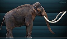
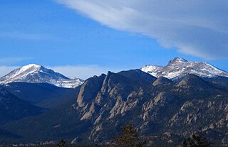
People have been visiting the area near Rocky Mountain National Park for at least 11,000 years, including the Lindenmeier and Dent sites where projectile points were found that were used to hunt Mammoth [15] and Bison antiquus . [1] Both Clovis and Folsom projectile points have been found in the park, [16] some near Trail Ridge. This indicates that there were early hunters, or Paleo-Indians, of large and now extinct mammals, like mastodons and bison antiquus, that traveled through the park. Their shelters were animal hide tents, brush huts, or rock shelters. [1] They traveled into the Rocky Mountain National Park area using a trail that is now Trail Ridge Road. [2]

The Paleo-Indians began hunting smaller, modern bison and looked for many sources of food in nature when they adopted the lifestyle of the Archaic period about eight thousand years ago. Projectile points have been found at Fall River Pass, on Flattop Mountain, at Forest Canyon Pass, on a slope above Chapin Pass, near Oldman Mountain, and other places in the park. Archeologist Wilfred M. Husted said, "Evidence indicates intermittent occupation of the Park rather than continuous occupation. Travel back and forth across the Continental Divide was the primary reason why Indians entered the mountains. Small camps indicate seasonal hunting in the valleys and on the mountains." [1]

Within the park there are archeological remains from about 3,850 to 3,400 B.C. of 42 low-walled stone structures or cairns, up to hundreds of feet in length, built for game drive systems. [17] Remains of such structures were found on Mount Ida, Tombstone Ridge, and on Trail Ridge Road. [18] These slight walls served as devices that permitted hunters to direct or herd game animals—like bison, sheep, deer, or elk— toward men waiting with weapons. Up to twenty-five people may have been needed to execute the game drive. Hunters may have killed the animals using darts, atlatl, spear throwers, or spears tipped with stone projectile points. [17] A game drive sites was used in this timeframe in an alpine area south of the park (like Mount Albion complex). Since they were temporary camping sites, it was assumed that people still came to the area to hunt and did not live in the mountainous region during the winter. [15]

Bows and arrows were used to hunt animals by 400 to 650 A.D., [15] [1] and pottery pieces have been found in the park that are dated to this period of time. [1] The Paleo-Indians also continued to use game drives to hunt for meat until about 1000 AD. [15] As hunter-gatherers, they also foraged for roots and berries for sustenance. [15]

Native Americans

Ute man Ute American Indian Mongoloid.png
Ute man

Between 1000 and 1300 AD, Ute people moved into the Rocky Mountain and western slope areas of Colorado, perhaps from the Great Basin of Utah. [3] The Ute, who were hunter-gatherers, traveled along Ute trail. Their belongings were carried by the Utes or were pulled by dogs with travois, until they had horses. The Utes camped in bands or small family groupings and stayed in the park area during the summer months and in Estes Park for the winter. Their diet included bison, elk, bighorn sheep, jackrabbit, antelope, deer, berries and roots. [3] When food was scarce, they ate tree bark. [8] In the early 1800s, the Arapaho pushed the Utes out of Estes Park. [8]

In the early 1800s, the northern Arapaho entered into the Rocky Mountain regions of Colorado. At first, they sought lodgepole pines for their tepees from the Kawuneeche Valley. They then spent more time in the Estes Park and surrounding area. The Arapaho also pressed for access to the North Park, Middle Park, and South Park areas, which had been controlled by the Utes. [4] There was a significant battle between the Arapaho and Ute at Grand Lake in which Ute women and children paddled a raft out to the middle of the lake for safety, but were drowned during a sudden storm. [19]

An old Arapaho camp was located at Marys Lake. They had names for many of the sites within the park, often based upon an event or residing animals, which was published in Arapaho Names and Trails. [20] The Arapaho left before 1860 when the area was settled by people of European descent. [8] By 1878, the northern Arapaho were forced into a reservation at Wind River Indian Reservation. [4]

An example of a modern cairn at Flattop Mountain Cairn on Flattop Mountain.jpg
An example of a modern cairn at Flattop Mountain

There were three main trails used by the Ute and Arapaho people to travel between Middle Park and Estes Park. One was called Dog Trail, because the Arapaho had dogs pull travois over the snowy trail, is now called Fall River trail. Child's trail has a spot where children had to get off their horses due to the steep terrain; that trail is now Ute Trail and Trail Ridge Road. Big Trail, which went over Flattop Mountain to the Kawuneeche Valley, was used by fast-traveling warriors. [21] Stone cairns were used by the Arapahos and the Utes to mark the forest trails. [22]

There are hundreds of sites with evidence of Native American visits, [23] including Tepee rings found along the Thompson River [24] and other signs of summer camps. [25] Stone and bone tools used for hunting, butchering, processing hides, and cooking have been found in the park. [26] Additionally, Native Americans carried river boulders to the top of Oldman Mountain, the site of their ceremonial vision quests. [25]

The Apache, Cheyenne, Sioux, and Shoshone periodically hunted or raided the area. [23] Comanche people may have also hunted in the Rocky Mountains for hundreds of years. [1]

19th-century explorers and settlers

Little has been recorded of Europeans who might have seen or visited the Rocky Mountain National Park area before the 19th century. [7] French fur trappers visited in 1700s and gave Native Americans firearms in trades. [7] A couple of French trappers called Longs Peak and Mount Meeker Les Deux Oreilles ("two ears") in 1799. [27] Don Pedro de Villasur led a group of one hundred men from New Spain up the South Platte River into Nebraska and may have seen the Front Range of Colorado. The Spaniards were attacked by unfriendly Pawnees, who killed 88 of the men, and the Spanish lost interest in traveling so far north again. [7]

American fur trappers came to Colorado in the early 19th century, but were seen as trespassers. James Pursley was trapping in the area, and he spotted gold in 1805. Joseph Bijeau—who was later a guide for the Long expedition—lived, hunted and trapped in the Rockies for six years. There were other trappers who worked along the Front Range. A. P. Chouteau and Julius De Munn traded with Native Americans for furs from 1811 to 1817, but were subject to having the furs they had acquired confiscated by Spanish patrols. Besides the threat of running into Spanish military patrols, the men were also subject to hostile Native American tribes. [7]

Long Expedition

Samuel Seymour, Longs Peak, 1820. Seymour, a member of Long's expedition, made a painting the first known depiction of the peak. Samuel Seymour, Longs Peak, 1820.tif
Samuel Seymour, Longs Peak , 1820. Seymour, a member of Long's expedition, made a painting the first known depiction of the peak.

Stephen Harriman Long of the U.S. Army Corps of Engineers, was engaged by President James Madison in 1819 to lead an expedition into the western frontier to document the topography, fauna, and flora encountered on the voyage to the headwaters of the Arkansas, Red River, and Platte Rivers. [5] The expeditionary team [lower-alpha 1] moved westward from the plains, [28] following the South Fork of the Platte River towards the mountains [6] and on the western horizon saw what Long identified the "highest peak" on June 30, 1820. [28] [29] [lower-alpha 2] By 1825, the name Longs Peak began appearing on maps. [28]

Rufus B. Sage

Rufus B. Sage traveled to the mountains in September 1843 and is believed to be the first white man to enter Estes Park. For a month, he hunted the abundant wildlife. [30] Sage described the area as a "concentration of beautiful lateral valleys, intersected by meandering watercourses, ridged by lofty ledges of precipitous rock, and hemmed in on the west by vast piles of mountains climbing beyond clouds." At the time of his visit, Ute and Arapaho lived in the area. [31] Sage published the earliest known description in Rocky Mountain Life, or Startling Scenes and Perilous Adventures in the Far West During an Expedition of Three Years. [32] He was one of the first people to write about the fur trapper's experiences in the vicinity. [33]

After the Mexican–American War (1846–1848) and during the gold rush, more people began to travel westward to the Rockies. [7]

Joel Estes

We stood on the mountain looking down at the headwaters of Little Thompson Creek, where the Park spread out before us. No words can describe our surprise, wonder and joy at beholding such an unexpected sight.

—Milton Estes said about their October 15, 1859 discovery. [7]

In October 1859, while on a hunting expedition, Joel Estes and his son Milton discovered land where "no signs that white men had ever been there before us." [34] In 1860, Joel Estes moved his family—which had included his wife Patsey, six children, five Black slaves, and a few friends—into two cabins that he built at the eastern edge of the park where Fish Creek, Lyons, and Loveland Roads converge. Estes brought his herd of cattle, [35] that were raised in the green pastures of the park. He hunted deer and elk and sold their meat and hides in Denver. [36] The Civil War broke out in 1861. During a trip that year to Missouri, where he was from, he freed his slaves. [7] In 1865, Charles F. Estes, son of Milton and Mary Flemming Estes, [37] was the first white child born in the park. [32] The winters were too harsh for Estes and he left the area in 1866. [36]

Griff Evans moved into the area lived in the Estes cabin. Between 1868 and 1873, he added a gable and made improvements to the cabin. [37] In 1926, the town of Estes Park erected a plaque in remembrance of the Estes family at the site of their cabin. [38]

William Byers

William Byers, editor of the Rocky Mountain News, visited Estes in 1864, and, climbed Mount Meeker when he was unable to find a route to the summit of Longs Peak. [36] His newspaper articles about his visit led to the naming of Estes Valley. [36] Byers, John Wesley Powell, and five other men made the first recorded ascent up Longs Peak in 1868. [39] [lower-alpha 3]

Joseph Wescott

Joseph Wescott moved to Grand Lake in the late 1860s after visiting Hot Sulphur Springs in Middle Park in the hopes of curing his crippling rheumatism. He built a cabin and hunted and fished for food. In the winter of 1867, though, the deep snows made it difficult for him to get the food he needed. He boiled the leather from a chair and supposedly from a pair of shoes for sustenance. He was saved by a hunting party. [41] Westcott was the first permanent resident of the area. [41]

Prior to Wescott, Philip Crenshaw built a cabin in 1858 and trapped animals for fur. [33] In 1868, tourists began arriving at Grand Lake. [41]

Growth

Estes Park became a tourist town beginning in the 1870s. [42] Byers and other adventurous writers came to the area and their published accounts of the area encouraged others to visit for its hunting, fishing, and scenery. [42] Frederick H. Chapin explored the area and published the book, Mountaineering in Colorado: The Peaks about Estes Park in 1889. A peak in the Mummy Range is named for Chapin and his wife named Ypsilon Mountain. [43]

People who moved to the area engaged in mining, ranching, and lodging. Some were also involved in the lumber industry. [42] The Griffith Sawmill that operated near Bierstadt Lake and a sawmill was established near Hidden Valley. [44]

Mining rush

Lulu City, Dutchtown, and Gaskill in the Never Summer Mountains were established in the 1870s when prospectors came to the area in search of gold and silver. [9] Joe Shipler staked two silver claims on Shipler mountain in 1879 and built two cabins along the Colorado River and the Lulu City trail. The town of Lulu at one point had 40 houses and a hotel, but the low-yield ore was unprofitable. The boom had ended by December 1883 when miners deserted their claims. [10] Dutchtown was abandoned by 1884.

Lord Dunraven

Lord Dunraven (1841-1926) 4thEarlOfDunraven.jpg
Lord Dunraven (1841-1926)

Windham Wyndham-Quin, 4th Earl of Dunraven and Mount-Earl, a famous sportsman, visited the area for the first time in 1872 [45] [lower-alpha 4] to hunt elk. [46] Two years later, he decided to purchase 8,000 acres along streams, which gave him access to a total of 15,000 acres, for a private game reserve [46] or cattle ranch. [45] He implemented a fraudulent scheme in which drifters made claims for 160 acres each under the Homestead Acts and acquired additional land through pre-emption rights. Dunraven then purchased the property from them for a nominal amount of money. [47]

Dunraven's land grab outraged locals. [46] Realizing that the private game reserve in Estes Park was not going to be a viable effort, Dunraven established a game park and hunting lodge in what is now Dunraven Glade, north of Estes Park. [46] He established a cattle ranch in Estes Park [46] called the "English Dairy", which had Swiss cattle that he brought into the area. [48] In July 1877, Dunraven opened the Estes Park Hotel, with a good view of the mountains. [45] Dunraven visited the area for the last time in the mid-1880s and abandoned much of his vast Estes Park claims. In 1885, he was made Undersecretary for the Colonies, which created increasing responsibilities to Queen Victoria. He also may have lost interest in Estes Park for a number of personal reasons. [45] Dunraven sold most of his lands and interests in the area in 1908 to F.O. Stanley and B.D. Sanborn. [45]

Albert Bierstadt

Albert Bierstadt, Estes Park and Longs Peak, 1876, Denver Art Museum was commissioned by the Earl of Dunraven Albert Bierstadt, Estes Park and Longs Peak, circa 1876.jpg
Albert Bierstadt, Estes Park and Longs Peak, 1876, Denver Art Museum was commissioned by the Earl of Dunraven

Albert Bierstadt, who may have been the first European to visit the summit of Mount Blue Sky, [49] Bierstadt was commissioned in 1876 by the Earl of Dunraven to make an exceptionally large canvas painting of Longs Peak and Estes Park for $15,000, equivalent to $412,219in 2022. He traveled throughout the area with Theodore Whyte, the earl's associate, and created sketches and paintings. The two men also looked for a suitable site, with a great view of Longs Peak, to construct an English hotel for the earl. [50] [43] Bierstadt took a particular interest in a lake, now called Bierstadt Lake. [49] Harold Marion Dunning, an early historian, said "that Bierstadt's favorite place for mountain sketches and material for some of his famous paintings was on the shore of the lake that now bears his name". [50] Bierstadt's painting of the lake is now in the Denver Art Museum's collection. [50]

Founding a national park

The Denver, Utah and Pacific Railroad reached Lyons, Colorado in 1881; and the Big Thompson Canyon Road was completed in 1904. Automobile stage lines offered transportation to Estes Park from Loveland in 1907 and from Lyons in 1909. [11]

Enos A. Mills, circa 1915 Enosmillsportrait cropped.jpg
Enos A. Mills, circa 1915
Dedication of Rocky Mountain National Park in 1916. (l to r): Stephen T. Mather, Robert Sterling Yard, Acting Superintendent Trowbridge, First Park Service Photographer Herford T. Cowling, and Horace M. Albright. RockyMountainNP Mather Yard.jpg
Dedication of Rocky Mountain National Park in 1916. (l to r): Stephen T. Mather, Robert Sterling Yard, Acting Superintendent Trowbridge, First Park Service Photographer Herford T. Cowling, and Horace M. Albright.

The movement to establish a national park in the Rocky Mountains in Colorado succeeded in 1915 because of the combined efforts of multiple groups of people over many years. [51] Prominent individuals in the effort included Enos Mills from the Estes Park area, James Grafton Rogers from Denver, and J. Horace McFarland of Pennsylvania. [13] Each of these men performed essential work for the cause. [52]

Enos Mills

Enos Mills, then a 14-year-old boy, moved to Estes Park in 1884. [53] He explored the mountains of the area and wrote many books and articles describing the region. [54] A resort owner, naturalist, and promoter of the conservation of nature, Mills pitched the idea of an "Estes National Park" in 1909, quickly earning the support of his fellow local businessmen in the form of the Estes Park Protective and Improvement Association. [52] He wrote essays predominantly for popular national magazines like The Saturday Evening Post, and these were published in book form during the more than five-year park campaign, promoting Colorado's Rocky Mountain region to the reading public: Wild Life on the Rockies (1909); The Spell of the Rockies (1911); In Beaver World (1913); and Rocky Mountain Wonderland (1915). [55] [56] Mills also toured the country speaking to audiences of the wonder and beauty of the Estes Park area, and gathered the support of influential friends as he went. [57]

Arapaho place names

The Colorado Geographical Society [lower-alpha 5] arranged for two Arapaho elders to return to the park in 1914 and share their names of places before the U.S. Geological Society printed maps of the park. Some of the places in the park that bear Native American names are Nokhu Crags ("rocks where the eagles nest"), Kawuneechee ("coyote") Valley, and Mount Neota ("mountain sheep's heart"). [59]

Bill signed

The bill passed Congress and was signed by President Woodrow Wilson on January 26, 1915. [14] A formal dedication ceremony was held on September 4, 1915 in Horseshoe Park. The park has expanded over the years, with the largest parcel — the Never Summer Range — added in 1929.

Developing a national park

The 1920s saw a boom in building lodges and roads in the park, culminating with the construction of Trail Ridge Road to Fall River Pass between 1929 and 1932, then to Grand Lake by 1938. [12] The Civilian Conservation Corps handled several building projects during the Great Depression and remnants of their camps can be found in the park today.[ citation needed ]

Rocky Mountain National Park was a place for downhill skiing. Hidden Valley (Ski Estes Park) operated between 1955 and 1991 along U.S. 34, five miles (8.0 km) west of Estes Park. The area had been skied by locals long before it opened as a ski area. [60]

Agnes Vaille

Not all leave Longs Peak alive and safe. There is a stone gazebo at the Keyhole formation with a plaque memorializing Agnes Vaille, a well-known climber in the 1920s. In January 1925, Vaille fell 100 ft (30 m) while descending the North Face. Vaille survived the fall with minor injuries, but was unable to walk. Her climbing partner, professional mountaineering guide Walter Kiener, went for help; but when rescuers arrived, Vaille had died of fatigue and hypothermia. One of the rescuers, Herbert Sortland, froze to death after breaking his hip while trying to rescue her. [61]

21st-century environmental events

On June 24, 2010, a wildfire burned over 1,500 acres (6.1 km2) of the park in Larimer County near Estes Park. Estes Park Fire Department believed that lightning may have started the fire.

In September 2013, both the park and the town of Estes Park were heavily damaged by a significant 500-year rain event. The park was closed to visitors September 12–19, 2013, and all roads leading to the park entrance from the east were closed for several days to several weeks. At one point, the only way to leave the town of Estes Park was via Trail Ridge Road, the park's scenic byway leading to the town of Grand Lake on the western side of the Continental Divide. The most lasting impacts inside the park were in the Alluvial Fan area, where flood waters, rocks, and debris washed away parking areas, and much of Fall River Road. [62] After repairs, the road reopened on July 2, 2015.

Notes

  1. Long, a topographical engineer, led a crew of 19, which included Titian Peale, a naturalist and artist; Samuel Seymour, a landscape painter; Thomas Say, a zoologist, and Edwin James, a physician, geologist, and botanist. [28] They were led by three French guides, including Joseph Bijeau who had lived, hunted, and trapped furs in the Rockies for six years. [7]
  2. The U S Corps of Topographical Engineers said that the group named the summit Longs Peak for their leader. [6] McDonald states that Long identified the "highest peak". [29] and it was not known as Longs Peak until 1825 when the name was used on maps. [28]
  3. J.W. Goss, a St. Vrain Valley settler, and Robert J. Woodward, a Boulder rancher, said that they climbed Longs Peak on June 16, 1865, but there was no evidence or reporting of their climb at the time. [40]
  4. A book by the National Park Service in 1919 states that Dunraven first came to the park in 1869, [32] but the current article about him on the National Park Service website states that he came to the United States in 1869 for his honeymoon, but visited cities on the eastern seaboard, New York and Richmond. [45]
  5. The Colorado Mountain Club was believed to have arranged for the Arapaho elders to visit the park, per Kenneth Jessen in Arapaho Indians shared knowledge of Rocky Mountain National Park, [20] while Perry said it was the Colorado Mountain Club [58]

Citations

  1. 1 2 3 4 5 6 7 Buchholtz, "Chap. 1" 1983a.
  2. 1 2 Perry 2008, p. 9; Buchholtz, "Chap. 1" 1983a.
  3. 1 2 3 Buchholtz, "Chap. 1" 1983a; Law 2015, pp. 53–54.
  4. 1 2 3 4 Law 2015, p. 76.
  5. 1 2 Buckley and Nokes 2016, p. 131.
  6. 1 2 3 U.S. Corps of Topographical Engineers.
  7. 1 2 3 4 5 6 7 8 9 Buchholtz, "Chap. 2" 1983b.
  8. 1 2 3 4 Law 2015, pp. 53–54.
  9. 1 2 Perry 2008, p. 18.
  10. 1 2 Perry 2008, pp. 50.
  11. 1 2 Cammerer, Arno B. (1934). Rocky Mountain National Park. Washington DC: United States Government Printing Office.
  12. 1 2 "History of Trail Ridge Road". nps.gov. National Park Service. Retrieved March 22, 2017.
  13. 1 2 Frank 2013, pp. 7–8; Buchholtz, "Chap. 5" 1983e.
  14. 1 2 "Brief Park History". nps.gov. National Park Service. Archived from the original on October 8, 2016. Retrieved March 22, 2017.
  15. 1 2 3 4 5 Perry 2008, p. 9.
  16. Perry 2008, p. 9; Uhler 2007.
  17. 1 2 Buchholtz, "Game drive system" 1983e.
  18. Perry 2008, pp. 11–12.
  19. Law 2015, p. 79.
  20. 1 2 Jennsen 2014.
  21. Law 2015, p. 24.
  22. Law 2015, p. 64.
  23. 1 2 History Colorado: Archaeology.
  24. Perry 2008, p. 14.
  25. 1 2 Uhler 2007.
  26. Perry 2008, pp. 15–16.
  27. McDonald 2004, p. 40; Evans 2010, p. 5.
  28. 1 2 3 4 5 6 Evans 2010, p. 5.
  29. 1 2 3 McDonald 2004, p. 40.
  30. Wuerthner 2001, p. 50.
  31. Harrigan 2013, pp. 122–123.
  32. 1 2 3 "National Park Service" 1919, p. 35.
  33. 1 2 Perry 2008, p. 19.
  34. Evans 2010, pp. 5–6.
  35. Evans 2010, p. 6; Buchholtz, "Chap. 2" 1983b; Perry 2008, p. 19, 20.
  36. 1 2 3 4 Evans 2010, p. 6.
  37. 1 2 Perry 2008, p. 20.
  38. Mills 1988, p. 308.
  39. "National Park Service" 1919, p. 35; Evans 2010, pp. 7.
  40. Evans 2010, pp. 6–7.
  41. 1 2 3 Buchholtz, "Chap. 3" 1983c.
  42. 1 2 3 Perry 2008, p. 45.
  43. 1 2 Perry 2008, p. 66.
  44. Perry 2008, pp. 46–48.
  45. 1 2 3 4 5 6 Atkins: Earl of Dunraven.
  46. 1 2 3 4 5 Dannen 1976.
  47. Dannen 1976; Atkins: Earl of Dunraven.
  48. Perry 2008, p. 46.
  49. 1 2 Byers 1890, p. 237.
  50. 1 2 3 Trail Gazette: Catch the Vision 2008.
  51. Frank 2013, pp. 7–8.
  52. 1 2 Frank 2013, p. 12; Buchholtz, "Chap. 5" 1983e.
  53. Malitz 2005, p. 45.
  54. National Park Service, Mills biography.
  55. Mills, Enos A.; Pickering, James H. (1989). "Introduction". The spell of the Rockies (reprint of 1911 ed.). Lincoln: University of Nebraska Press. pp. xxi–xxii. ISBN   0803281633.
  56. Mills, Enos A.; Pickering, James H. (1991). "Introduction". The Rocky Mountain wonderland (reprint of 1915 ed.). Lincoln: University of Nebraska Press. pp. xxxiv–xxxvii. ISBN   0803281730.
  57. Buchholtz, "Chap. 5" 1983e.
  58. Perry 2008, p. 17.
  59. Perry 2008, p. 17; Law 2015, p. 76.
  60. "Hidden Valley Ski Area" . Retrieved 2007-12-02.
  61. Nesbit, Paul. Longs Peak. 1990
  62. "Old Fall River Road a short-term flood casualty". Estes Park Trail Gazette. 12 December 2013. Retrieved 2013-12-23.

Related Research Articles

<span class="mw-page-title-main">Larimer County, Colorado</span> County in Colorado, United States

Larimer County is a county located in the U.S. state of Colorado. As of the 2020 census, the population was 359,066. The county seat and most populous city is Fort Collins. The county was named for William Larimer, Jr., the founder of Denver.

<span class="mw-page-title-main">Estes Park, Colorado</span> Town in Colorado, United States

Estes Park is a statutory town in Larimer County, Colorado, United States. The town population was 5,904 at the 2020 United States Census. Estes Park is a part of the Fort Collins, CO Metropolitan Statistical Area and the Front Range Urban Corridor. A popular summer resort and the location of the headquarters for Rocky Mountain National Park, Estes Park lies along the Big Thompson River. Landmarks include The Stanley Hotel and The Baldpate Inn. The town overlooks Lake Estes and Olympus Dam.

<span class="mw-page-title-main">Longs Peak</span> Mountain in Colorado, United States

Longs Peak is a high and prominent mountain in the northern Front Range of the Rocky Mountains of North America. The 14,259-foot (4346 m) fourteener is located in the Rocky Mountain National Park Wilderness, 9.6 miles (15.5 km) southwest by south of the Town of Estes Park, Colorado, United States. Longs Peak is the northernmost fourteener in the Rocky Mountains of Colorado and the highest point in Boulder County and Rocky Mountain National Park. The mountain was named in honor of explorer Stephen Harriman Long and is featured on the Colorado state quarter.

<span class="mw-page-title-main">Rocky Mountain National Park</span> National park in Colorado, United States

Rocky Mountain National Park is an American national park located approximately 55 mi (89 km) northwest of Denver in north-central Colorado, within the Front Range of the Rocky Mountains. The park is situated between the towns of Estes Park to the east and Grand Lake to the west. The eastern and western slopes of the Continental Divide run directly through the center of the park with the headwaters of the Colorado River located in the park's northwestern region. The main features of the park include mountains, alpine lakes and a wide variety of wildlife within various climates and environments, from wooded forests to mountain tundra.

<span class="mw-page-title-main">Trail Ridge Road</span> Colorado Scenic and Historic Byway

Trail Ridge Road is the name for the 48-mile (77 km) stretch of U.S. Highway 34 that traverses Rocky Mountain National Park from Estes Park, Colorado in the east to Grand Lake, Colorado in the west. Together with the connecting 6.9-mile (11 km) Beaver Meadow Road, Trail Ridge Road forms the 55-mile (89 km) Trail Ridge Road/Beaver Meadow National Scenic Byway, an All-American Road. With a high point at 12,183 feet (3,713 m) elevation, Trail Ridge Road is the highest continuous paved road in North America. The higher portion of Trail Ridge Road is closed from October to May.

<span class="mw-page-title-main">Mount Blue Sky</span> Mountain in Colorado, United States

Mount Blue Sky is the highest peak in the Mount Evans Wilderness in the Front Range of the Rocky Mountains of North America. The prominent 14,271-foot (4,350 m) fourteener is located 13.4 miles (21.6 km) southwest by south of Idaho Springs in Clear Creek County, Colorado, United States, on the drainage divide between Arapaho National Forest and Pike National Forest.

<span class="mw-page-title-main">Mount Bierstadt</span> Mountain in Colorado, United States

Mount Bierstadt is a 14,065-foot-high (4,287 m) mountain summit in the Front Range of the Rocky Mountains, in the U.S. state of Colorado. The fourteener is located in the Mount Evans Wilderness of Pike National Forest, 9.4 miles (15.1 km) south by east of the Town of Georgetown in Clear Creek County. It was named in honor of Albert Bierstadt, an American landscape painter who made the first recorded summit of the mountain in 1863.

<span class="mw-page-title-main">Never Summer Mountains</span> Mountain range in Colorado, US

The Never Summer Mountains are a mountain range in the Rocky Mountains in north central Colorado in the United States consisting of seventeen named peaks. The range is located along the northwest border of Rocky Mountain National Park, forming the continental divide between the headwaters of the Colorado River in Rocky Mountain National Park to the local-east and the upper basin of the North Platte River to the local-west; the continental divide makes a loop in these mountains. The range is small and tall, covering only 25 sq mi (65 km2) with a north–south length of 10 mi (16 km) while rising to over 12,000 ft (3,700 m) at over ten distinct peaks. The range straddles the Jackson-Grand county line for most of its length, and stretches into Jackson and Larimer county at its northern end. A panoramic view of the range is available from sections of Trail Ridge Road in Rocky Mountain National Park. One of the northernmost peaks, Nokhu Crags, is prominently visible from the west side of Cameron Pass.

<span class="mw-page-title-main">Mummy Range</span> Mountain range in northern Colorado, United States

The Mummy Range is a mountain range in the Rocky Mountains of northern Colorado in the United States. The range is a short subrange of the Front Range located in southwestern Larimer County northwest of the town of Estes Park. It is located largely within Rocky Mountain National Park, extending north from Trail Ridge Road approximately 15 mi (24 km). The Arapaho name is "nooku-bee3ei-no," which translates to "White Owls."

<span class="mw-page-title-main">Windham Wyndham-Quin, 4th Earl of Dunraven and Mount-Earl</span> Irish nobleman and Conservative politician

Windham Thomas Wyndham-Quin, 4th Earl of Dunraven and Mount-Earl,, styled Viscount Adare between 1850 and 1871, was an Anglo-Irish journalist, landowner, entrepreneur, sportsman and Conservative politician. He served as Under-Secretary of State for the Colonies under Lord Salisbury from 1885 to 1886 and 1886 to 1887. He also successfully presided over the 1902 Land Conference and was the founder of the Irish Reform Association. He recruited two regiments of sharpshooters, leading them in the Boer War and later establishing a unit in Ireland.

<span class="mw-page-title-main">Indian Peaks Wilderness</span>

The Indian Peaks Wilderness is a wilderness area in north central Colorado managed jointly by the United States Forest Service and the National Park Service within the Arapaho and Roosevelt National Forests and small parts of the southern section of Rocky Mountain National Park. It borders the James Peak Wilderness to the south, and straddles the Continental Divide. The area receives high visitation due to its proximity to the Denver metropolitan area.

The Trail Ridge Road/Beaver Meadow National Scenic Byway is a 55-mile (89 km) All-American Road and Colorado Scenic and Historic Byway located in Rocky Mountain National Park in Larimer and Grand counties, Colorado, USA. The byway consists of the 48-mile (77 km) Trail Ridge Road and the connecting 6.9-mile (11 km) Beaver Meadow Road. With a high point at 12,183 feet (3,713 m) elevation, Trail Ridge Road is the highest continuous paved road in North America. The higher portion of Trail Ridge Road is closed from October to May. The Rocky Mountain National Park Administration Building is a National Historic Landmark.

<span class="mw-page-title-main">U.S. Route 34 in Colorado</span> Highway in Colorado

U.S. Route 34 (US 34) is a part of the U.S. Highway System that travels from Granby, Colorado, to Berwyn, Illinois. In the U.S. state of Colorado, US 34 is a 260-mile-long (420 km) road that spans across northern Colorado. It begins at US 40 in Granby and ends at the Nebraska border, where it continues as US 34, east of Laird.

Prehistory of Colorado provides an overview of the activities that occurred prior to Colorado's recorded history. Colorado experienced cataclysmic geological events over billions of years, which shaped the land and resulted in diverse ecosystems. The ecosystems included several ice ages, tropical oceans, and a massive volcanic eruption. Then, ancient layers of earth rose to become the Rocky Mountains.

The Peak to Peak Scenic Byway is a 55-mile (89 km) National Forest Scenic Byway and Colorado Scenic and Historic Byway located in Gilpin, Boulder, Larimer counties, Colorado, USA. The Peak to Peak Highway was originally built in 1918 and provides views of the Front Range mountains in the Colorado Rocky Mountains. It was Colorado's first scenic highway. The Central City/Black Hawk Historic District is a National Historic Landmark.

<span class="mw-page-title-main">Bierstadt Lake</span> Lake in Colorado, United States

Bierstadt Lake is located in Larimer County, Colorado and within the Rocky Mountain National Park. Near McHenrys Peak and Longs Peak, there are "spectacular views" of the Continental Divide at the lake. The Bierstadt Lake Trailhead is located about 6.5 miles (10.5 km) from the turn-off at U.S. Route 36 into the Rocky Mountain National Park. During the summer, shuttle buses provide transportation to the trailhead.

<span class="mw-page-title-main">Horseshoe Park</span>

Horseshoe Park is a flat at 8,524 feet (2,598 m) in elevation in Larimer County, Colorado. It is within the Rocky Mountain National Park, which lies between Estes Park to the east and Grand Lake, Colorado on the west. Horseshoe Park is home to bighorn sheep, elk and other wildlife, and it is a wetland sanctuary for a wide variety of birds. Recreational activities include picnicking, hiking, cross-country skiing and snowshoeing. Roaring River, Lawn Lake and Crystal Lake are located here.

<span class="mw-page-title-main">Elkanah Lamb</span>

Elkanah J. Lamb was born in Indiana and moved westward through Iowa to Kansas and Nebraska during his early adulthood. He became a minister of the Church of the United Brethren and traveled through the Kansas and Nebraska frontier to preach to people in their homes or school houses. Lamb spent a year in Colorado as a missionary. During that time, he visited Estes Park and climbed Longs Peak. Lamb's slide on Longs Peak is named for his treacherous descent in 1871.

References