
Sourdough Glacier is in the Wind River Range, Bridger-Teton National Forest in the U.S. state of Wyoming. Sourdough Glacier is in the Bridger Wilderness, and is part of the largest grouping of glaciers in the American Rocky Mountains. The glacier extends from the north slope of Klondike Peak at an elevation range of 12,800 to 11,800 ft and flows into a proglacial lake.
J Glacier is located in Bridger-Teton National Forest, in the US state of Wyoming on the west of the Continental Divide in the Wind River Range. J Glacier is in the Bridger Wilderness, and is part of the largest grouping of glaciers in the American Rocky Mountains. J Glacier flows down from the northwest slope of Klondike Peak and a proglacial lake has formed at the toe of the glacier.

Minor Glacier is in Bridger-Teton National Forest, in the U.S. state of Wyoming on the west side of the Continental Divide in the northern Wind River Range. Minor Glacier is in the Bridger Wilderness and is part of the largest grouping of glaciers in the American Rocky Mountains. The glacier is situated below the west flank of Gannett Peak, the tallest mountain in Wyoming.
Gooseneck Glacier is located in the Fitzpatrick Wilderness, Shoshone National Forest, in the US state of Wyoming. The glacier is east of the Continental Divide in the northern Wind River Range and on the southeast flank of Gannett Peak, the tallest mountain in Wyoming. Gooseneck Glacier is separated from Dinwoody Glacier by a rocky outcropping and they are part of the largest grouping of glaciers in the American Rocky Mountains.

Stroud Glacier is west of the Continental Divide in the northern Wind River Range in the U.S. state of Wyoming. The glacier is located in the Bridger Wilderness of Bridger-Teton National Forest, and is among the largest grouping of glaciers in the American Rocky Mountains. The glacier is situated in a north facing cirque, below the summit of Bow Mountain.
Twins Glacier is west of the Continental Divide in the northern Wind River Range in the U.S. state of Wyoming. The glacier is located in the Bridger Wilderness of Bridger-Teton National Forest, and is among the largest grouping of glaciers in the American Rocky Mountains. The glacier is situated in a northeast facing cirque, below the summit of Winifred Peak.
Heap Steep Glacier is located east of the Continental Divide in the northern Wind River Range in the US state of Wyoming. The glacier is situated in the Fitzpatrick Wilderness of Shoshone National Forest, and is among the largest grouping of glaciers in the American Rocky Mountains. Heap Steep Glacier is in a north facing cirque, below the summit of Sunbeam Peak. A large terminal moraine and small proglacial lake are located below the glacier.
Harrower Glacier is located on the west side of the Continental Divide in the northern Wind River Range in the US state of Wyoming. The glacier is in the Bridger Wilderness of Bridger-Teton National Forest, and is among the largest grouping of glaciers in the American Rocky Mountains. Harrower Glacier flows to the north and is situated in a cirque, below the summit of Knife Point Mountain.

Tyndall Glacier is a small cirque glacier in Rocky Mountain National Park in the U.S. state of Colorado. Tyndall Glacier is on the east side of the Continental Divide and in a cirque to the north of Hallett Peak. Tyndall Glacier is both an ice and a rock glacier, with the lower portions of the glacier being composed primarily of rock debris and a small portion of ice.
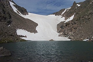
Andrews Glacier is an alpine glacier in a cirque below Otis Peak in Rocky Mountain National Park in the U.S. state of Colorado. The glacier extends from Andrews Pass at nearly 12,000 to 11,700 feet with some perennial snow extending to Andrews Tarn, a small proglacial lake. When images of the glacier taken in the early 1900s are compared with those of the early 2000s, Andrews Glacier is showing a negative glacier mass balance which indicates the glacier is retreating.

Kootenai Peak is located in the Lewis Range, Glacier National Park in the U.S. state of Montana. Kootenai Peak is in the northeastern section of Glacier National Park.

Chapman Peak is located in the Livingston Range, Glacier National Park in the U.S. state of Montana. Chapman Peak is situated along the Continental Divide. The mountain is named for Robert H. Chapman, one of the US Geological Survey topographers who worked on mapping Glacier Park between 1900 and 1904.

Arapaho Glacier is an alpine glacier in a cirque immediately southeast of North Arapaho Peak, in Roosevelt National Forest in the U.S. state of Colorado. The glacier is just east of the Continental Divide. Arapaho Glacier is the largest glacier in the state of Colorado and helps provide water for the city of Boulder, Colorado. The glacier has a negative glacier mass balance and lost over 52% of its surface area during the 20th Century.
Mills Glacier is an alpine glacier near the base of the east mountain face of Longs Peak, in Rocky Mountain National Park in the U.S. state of Colorado.
Moomaw Glacier is an alpine glacier in Rocky Mountain National Park in the U.S. state of Colorado. Moomaw Glacier is almost 1 mi (1.6 km) northeast of Isolation Peak and the old terminal moraine of the glacier impounds Frigid Lake.
Rowe Glacier is an alpine glacier in Rocky Mountain National Park in the U.S. state of Colorado. It is 300 yd (270 m) north of Hagues Peak and the source of the North Fork Big Thompson River. Rowe Glacier was the first glacier to be identified in Colorado.
The Saint Vrain Glaciers are small alpine glaciers located in Roosevelt National Forest in the U.S. state of Colorado. The glaciers are just south of Rocky Mountain National Park and east of the Continental Divide in northeast facing cirques.
Sprague Glacier is a small cirque glacier in Rocky Mountain National Park in the U.S. state of Colorado. Sprague Glacier is on the east side of the Continental Divide and .25 mi (0.40 km) southeast of Sprague Mountain. Several small alpine lakes are near the foot of the glacier.
Taylor Glacier is a small cirque glacier in Rocky Mountain National Park in the U.S. state of Colorado. Taylor Glacier is on the east side of the Continental Divide and adjacent to Taylor Peak. Taylor Glacier is both an ice and a rock glacier, with the lower portions of the glacier being composed primarily of rock debris and a small portion of ice.

Taylor Peak, elevation 13,158 ft (4,011 m), is a summit in the Front Range of north central Colorado. The peak is in Rocky Mountain National Park at the head of Loch Vale and just north of Taylor Glacier.
