
Saul is a village in County Down, Northern Ireland, within the civil parish of Saul and Ballee.

Drumbeg is a small village, townland and civil parish on the south bank of the River Lagan in County Down, Northern Ireland. The village is covered by the Lisburn City Council area and forms part of the suburban fringe of Belfast.

Lambeg is a small village and civil parish in County Antrim, Northern Ireland. Located between Belfast and Lisburn, it was once a small rural village, but is now within the Greater Belfast conurbation. Lambeg is also an electoral ward of Lisburn Council. In the 2001 Census it had a population of 60 people. The civil parish of Lambeg covers areas of County Down as well as County Antrim.

Drumbo is a small village, townland and civil parish in County Down, Northern Ireland. It is about 6 miles (10 km) south of Belfast city centre, 3 miles (5 km) east of Lisburn and 3 miles (5 km) west of Carryduff. It is in the historic barony of Castlereagh Upper.

Ardstraw is a small village, townland and civil parish in County Tyrone, Northern Ireland, three miles northwest of Newtownstewart. In the 2001 Census it had a population of 222 people.
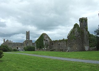
Quin is a village in southeast County Clare, Ireland. The name also refers to a civil parish in the barony of Bunratty Upper, and to an ecclesiastical parish of the same name. The main attraction in the vicinity is Quin Abbey, the ruins of Franciscan friary, which is open to the public. Although roofless, much of the structure remains and is relatively well-preserved. The abbey was built on the foundations of an earlier Norman castle; the foundations of three corner towers can still be seen.
Ballynahone Beg is a townland lying within the civil parish of Maghera, County Londonderry, Northern Ireland. It lies in the south-west of the parish, and is bounded by the townlands of; Ballynahone More, Clooney, Craigadick, Drumballyhagan, Drumballyhagan Clark, Fallagloon, Falgortrevy, Mullagh, and Tobermore. It was not apportioned to any of the London livery companies, being retained as church lands.

Craigadick is a townland lying within the civil parish of Maghera, County Londonderry, Northern Ireland. It lies in the west of the parish sharing a small boundary with Killelagh civil parish. It is bounded by the townlands of; Ballynahone Beg, Craigmore, Falgortrevy, Largantogher, Moneymore, Mullagh, Tamnymullan, and Tullyheran. It wasn't apportioned to any of the London livery companies, being kept as church lands.
Craigmore is a townland lying within the civil parish of Maghera, County Londonderry, Northern Ireland. It lies on the west boundary of the parish, and is bounded by the townlands of; Craigadick, Falgortrevy, Grillagh, Tamnymullan, and Tirnony. It wasn't apportioned to any of the London livery companies, being kept as church lands.
Falgortrevy is a townland lying within the Civil parishes in Ireland of Maghera, County Londonderry, Northern Ireland. It lies on the western boundary of the parish and is divided into two portions; Falgortrevy and Falgortrevy, separated by small portions of the townlands of Craigadick and Tullyheran. The detached portion is also bounded by the townlands of Craigmore and Tirnony, whilst the main portion is also bounded by the townlands of Ballynahone Beg and Fallagloon. It wasn't apportioned to any of the London livery companies, being kept as church lands.
Ballymacpeake Upper is a townland lying within the civil parish of Maghera, County Londonderry, Northern Ireland. It lies in the east of the parish on the boundaries of the civil parishes of Ballyscullion and Tamlaght O'Crilly. It is also bounded by the townlands of Ballymacombs Beg, Ballymacpeake Lower, Dreenan, Drumard, Drumlamph, Mullaghboy, and Rocktown. It was apportioned to the Vintners company.
Beagh (Spiritual) is a townland lying within the civil parish of Maghera, County Londonderry, Northern Ireland. It lies in the south of the parish on the north boundary of the civil parish of Termoneeny, and is bounded by the townlands of Carricknakielt, Curragh, Maghera civil parish~Curragh, Knocknakielt, Slaghtybogy, and Tamnymartin. It wasn't apportioned to any of the London livery companies, being kept as church lands.
Maghera is a parish in County Londonderry, Northern Ireland. It is bordered by the parishes of Ballynascreen, Ballyscullion, Desertmartin, Dungiven, Kilcronaghan, Killelagh, Magherafelt, Tamlaght O'Crilly, and Termoneeny. As a civil parish it lies within the former barony of Loughinsholin and as an ecclesiastical parish it lies within the Church of Ireland Diocese of Derry and Raphoe.

Drumcliff, or Drumcliffe, Dromcliffe is a civil parish in County Clare, Ireland. It includes the village of Inch and part of the town of Ennis.

Iveagh Upper, Lower Half is the name of a barony in County Down, Northern Ireland. It was created by 1851 with the division of the barony of Iveagh Upper into two. It lies in the centre of the county, and is bordered by six other baronies: Iveagh Upper, Upper Half and Lordship of Newry to the west; Mourne to the south; Kinelarty and Lecale Upper to the east; and Iveagh Lower, Upper Half to the north.
Clooney is a civil parish of County Clare, Ireland, located to the northeast of Ennis, south of Inchicronan. The area is marshy, with the Oysterman's Marsh Natural Heritage Area in the vicinity. Clooney-Quin GAA is a GAA club for the Catholic parish of Clooney and Quin.
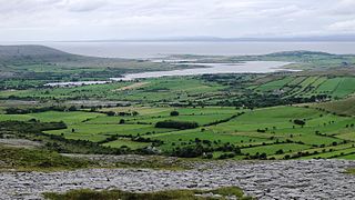
Oughtmama is a civil parish in County Clare. It lies in the Burren, a region in the northwest of the county. It contains many antiquities, including three early-medieval Christian churches, ruined castles, prehistoric cairns and ring forts and two Martello Towers built in the early 19th century.
Kilmanaheen is a civil parish in County Clare, Ireland. It contains the market town of Ennistymon.

Bright is a civil parish in County Down, Northern Ireland. It is situated in the historic barony of Lecale Upper. It is also a townland of 336 acres.

Maghera Churches and Round Tower is an ecclesiastical site in Maghera, County Down. It consists of the ruins of an 13th Century church, Maghera Parish Church and the stump of a 10th Century round tower. It is also the site of a monastery founded by St. Donard in the 6th century, and its graveyard confirms evidence that it was an early ecclesiastical site. Together the old church, round tower, and graveyard are a scheduled monument and monument in state care, referred to as "Maghera Church and Round Tower". The church built in 1825 is a functional Church of Ireland church and a listed building.


