Marcellon, Wisconsin

Last updated

Marcellon, Wisconsin
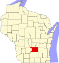
WIMap-doton-Marcellon.png
Location of Marcellon, Wisconsin
Coordinates: 43°35′58″N89°18′37″W / 43.59944°N 89.31028°W / 43.59944; -89.31028
Country Flag of the United States.svg  United States
State Flag of Wisconsin.svg  Wisconsin
County Columbia
Area
  Total35.8 sq mi (92.7 km2)
  Land35.5 sq mi (91.9 km2)
  Water0.3 sq mi (0.7 km2)
Elevation
[1]
928 ft (283 m)
Population
 (2000)
  Total1,024
  Density28.8/sq mi (11.1/km2)
Time zone UTC-6 (Central (CST))
  Summer (DST) UTC-5 (CDT)
FIPS code 55-49150 [2]
GNIS feature ID1583650 [1]

Marcellon is a town in Columbia County, Wisconsin, United States. The population was 1,024 at the 2000 census. The unincorporated community of Belle Fountain is located in the town.

Contents

Geography

According to the United States Census Bureau, the town has a total area of 35.8 square miles (92.7 km2), of which, 35.5 square miles (91.9 km2) of it is land and 0.3 square miles (0.7 km2) of it (0.78%) is water.

Demographics

As of the census [2] of 2000, there were 1,024 people, 362 households, and 287 families residing in the town. The population density was 28.8 people per square mile (11.1/km2). There were 380 housing units at an average density of 10.7 per square mile (4.1/km2). The racial makeup of the town was 98.93% White, 0.10% Asian, 0.10% Pacific Islander, 0.20% from other races, and 0.68% from two or more races. Hispanic or Latino of any race were 0.59% of the population.

There were 362 households, out of which 32.3% had children under the age of 18 living with them, 72.4% were married couples living together, 2.5% had a female householder with no husband present, and 20.7% were non-families. 15.7% of all households were made up of individuals, and 6.1% had someone living alone who was 65 years of age or older. The average household size was 2.83 and the average family size was 3.16.

In the town, the population was spread out, with 27.1% under the age of 18, 7.1% from 18 to 24, 26.8% from 25 to 44, 29.4% from 45 to 64, and 9.6% who were 65 years of age or older. The median age was 39 years. For every 100 females, there were 107.3 males. For every 100 females age 18 and over, there were 101.6 males.

The median income for a household in the town was $48,333, and the median income for a family was $50,625. Males had a median income of $31,759 versus $24,760 for females. The per capita income for the town was $19,488. About 6.7% of families and 8.2% of the population were below the poverty line, including 9.9% of those under age 18 and 13.5% of those age 65 or over.

Related Research Articles

<span class="mw-page-title-main">Elmore, Alabama</span> Town in Alabama, United States

Elmore is a town in Elmore County, Alabama, United States. Although initially incorporated in 1906, it lapsed and was not reincorporated again until 1997. At the 2010 census the population was 1,262, up from 199 in 2000. It is part of the Montgomery Metropolitan Statistical Area.

<span class="mw-page-title-main">Murtaugh, Idaho</span> City in Idaho, United States

Murtaugh is a city in Twin Falls County, Idaho, United States. The population was 115 at the 2010 census, down from 139 in 2000. It is part of the Twin Falls, Idaho Micropolitan Statistical Area.

<span class="mw-page-title-main">Winnebago, Illinois</span> Village in Illinois, United States

Winnebago is a village in Winnebago County, Illinois. It is part of the Rockford-Winnebago Metropolitan Statistical Area. The population was 3,101 at the 2010 census, up from 2,958 in 2000.

<span class="mw-page-title-main">Danville, Iowa</span> City in Iowa, United States

Danville is a city in Des Moines County, Iowa, United States. The population was 927 at the time of the 2020 census. It is part of the Burlington, IA–IL Micropolitan Statistical Area.

Detroit is a town in Somerset County, Maine, United States. The population was 885 at the 2020 census.

<span class="mw-page-title-main">Union Bridge, Maryland</span> Town in Maryland, United States

Union Bridge is a town in Carroll County, Maryland, United States. The population was 936 at the 2020 census.

<span class="mw-page-title-main">South Zanesville, Ohio</span> Village in Ohio, United States

South Zanesville is a village in Muskingum County, Ohio, United States, along the Muskingum River near the mouth of the Moxahala Creek. The population was 1,894 at the 2020 census. It is part of the Zanesville micropolitan area.

<span class="mw-page-title-main">Palmer Heights, Pennsylvania</span> Place in Pennsylvania, United States

Palmer Heights is a census-designated place (CDP) in Palmer Heights, Pennsylvania. The population of Palmer Heights was 3,762 at the 2010 census. Palmer Heights is part of the Lehigh Valley, which had a population of 861,899 and was the 68th-most populous metropolitan area in the U.S. as of the 2020 census.

<span class="mw-page-title-main">Barry Township, Pennsylvania</span> Township in Pennsylvania, United States

Barry Township is a township in Schuylkill County, Pennsylvania. Formed in 1822, it is named for American Revolutionary War Commander John Barry and was formed from parts of Norwegian and Schuylkill Townships.

<span class="mw-page-title-main">Cross Timber, Texas</span> Town in Texas, United States

Cross Timber is a town in Johnson County, Texas, United States. As of the 2010 census the population was 268.

<span class="mw-page-title-main">Granville, West Virginia</span> Town in West Virginia

Granville is a town in Monongalia County, West Virginia, United States. The population was 1,355 at the 2020 census. It is included in the Morgantown metropolitan area.

<span class="mw-page-title-main">Lester, West Virginia</span> Town in West Virginia, United States

Lester is a town in Raleigh County, West Virginia, United States. The population was 337 at the 2020 census. The community was named after Champ Lester, a local pioneer.

<span class="mw-page-title-main">Peru, Wisconsin</span> Town in Wisconsin, United States

The Town of Peru is a Town located in Dunn County, Wisconsin, United States. The population was 247 at the 2000 census. The unincorporated communities of Meridean and Red Cedar and the ghost towns of Old Tyrone and Old Meridean are located in the town.

<span class="mw-page-title-main">Lamartine, Wisconsin</span> Town in Wisconsin, United States

Lamartine is a town in Fond du Lac County, Wisconsin, United States. The population was 1,616 at the 2000 census. The unincorporated communities of Lamartine, Rogersville, and Woodhull are located in the town.

<span class="mw-page-title-main">Hortonia, Wisconsin</span> Town in Wisconsin, United States

Hortonia is a town in Outagamie County, Wisconsin, United States. The population was 1,097 at the 2010 census.

<span class="mw-page-title-main">Rock Springs, Wisconsin</span> Village in Wisconsin, United States

Rock Springs is a village in Sauk County, Wisconsin, United States, along the Baraboo River. The population was 362 at the 2010 census.

<span class="mw-page-title-main">Green Valley, Shawano County, Wisconsin</span> Town in Wisconsin, United States

Green Valley is a town in Shawano County, Wisconsin, United States. The population was 1,024 at the 2000 census. The census-designated place of Green Valley and unincorporated communities of Advance and Pulcifer are located in the town.

<span class="mw-page-title-main">Corinth (village), New York</span> Village in New York, United States

Corinth is a village in Saratoga County, New York, United States. The population was 2,562 at the 2020 census. The village takes its name from the Greek city of Corinth.

<span class="mw-page-title-main">Cross Plains (town), Wisconsin</span> Town in Dane County, Wisconsin

Cross Plains is a town in Dane County, Wisconsin, United States. The population was 1,419 at the 2000 census. The Village of Cross Plains is located partially within the town. The unincorporated community of Pine Bluff is located in the town.

<span class="mw-page-title-main">Dane (town), Wisconsin</span>

Dane is a town in Dane County, Wisconsin, United States. The population was 968 at the 2000 census. The unincorporated community of Lutheran Hill is located partially in the town.

References

  1. 1 2 "US Board on Geographic Names". United States Geological Survey. October 25, 2007. Retrieved January 31, 2008.
  2. 1 2 "U.S. Census website". United States Census Bureau . Retrieved January 31, 2008.

43°34′07″N89°15′56″W / 43.56861°N 89.26556°W / 43.56861; -89.26556