Mason City, Nebraska

Last updated

Mason City, Nebraska
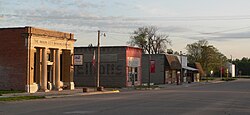
Mason City, Nebraska downtown 2.JPG
Mason City at sunrise
Custer County Nebraska Incorporated and Unincorporated areas Mason City Highlighted.svg
Location of Mason City, Nebraska
USA Nebraska relief location map.svg
Red pog.svg
Mason City
Location within Nebraska
Usa edcp relief location map.png
Red pog.svg
Mason City
Location within the United States
Coordinates: 41°13′20″N99°17′56″W / 41.22222°N 99.29889°W / 41.22222; -99.29889
Country United States
State Nebraska
County Custer
Township Algernon
Area
[1]
  Total0.48 sq mi (1.23 km2)
  Land0.48 sq mi (1.23 km2)
  Water0.00 sq mi (0.00 km2)
Elevation
[2]
2,264 ft (690 m)
Population
 (2020)
  Total151
  Density317.23/sq mi (122.37/km2)
Time zone UTC-6 (Central (CST))
  Summer (DST) UTC-5 (CDT)
ZIP code
68855
Area code 308
FIPS code 31-31115 [3]
GNIS feature ID2399271 [2]

Mason City is a village in Custer County, Nebraska, United States. The population was 171 at the 2010 census.

Contents

History

Mason City was platted in 1886 when the Burlington and Missouri River Railroad was extended to that point. [4] [5] The town was named for Oliver Perry Mason, a former Nebraska Supreme Court judge. [6]

Geography

According to the United States Census Bureau, the village has a total area of 0.47 square miles (1.22 km2), all land. [7]

Demographics

Historical population
CensusPop.Note
1900 241
1910 48099.2%
1920 4871.5%
1930 447−8.2%
1940 396−11.4%
1950 305−23.0%
1960 277−9.2%
1970 196−29.2%
1980 1960.0%
1990 160−18.4%
2000 17811.3%
2010 171−3.9%
2020 151−11.7%
U.S. Decennial Census [8]

2010 census

As of the census [9] of 2010, there were 171 people, 75 households, and 45 families living in the village. The population density was 363.8 inhabitants per square mile (140.5/km2). There were 93 housing units at an average density of 197.9 per square mile (76.4/km2). The racial makeup of the village was 94.2% White, 0.6% Native American, 1.2% Asian, and 4.1% from two or more races. Hispanic or Latino of any race were 2.3% of the population.

There were 75 households, of which 22.7% had children under the age of 18 living with them, 46.7% were married couples living together, 10.7% had a female householder with no husband present, 2.7% had a male householder with no wife present, and 40.0% were non-families. 34.7% of all households were made up of individuals, and 21.3% had someone living alone who was 65 years of age or older. The average household size was 2.28 and the average family size was 2.84.

The median age in the village was 47.4 years. 21.1% of residents were under the age of 18; 7.5% were between the ages of 18 and 24; 15.8% were from 25 to 44; 40.4% were from 45 to 64; and 15.2% were 65 years of age or older. The gender makeup of the village was 47.4% male and 52.6% female.

2000 census

As of the census [3] of 2000, there were 178 people, 72 households, and 49 families living in the village. The population density was 377.3 inhabitants per square mile (145.7/km2). There were 91 housing units at an average density of 192.9 per square mile (74.5/km2). The racial makeup of the village was 94.38% White, 3.37% Native American, and 2.25% from two or more races. Hispanic or Latino of any race were 0.56% of the population.

There were 72 households, out of which 30.6% had children under the age of 18 living with them, 61.1% were married couples living together, 4.2% had a female householder with no husband present, and 30.6% were non-families. 26.4% of all households were made up of individuals, and 20.8% had someone living alone who was 65 years of age or older. The average household size was 2.47 and the average family size was 3.02.

In the village, the population was spread out, with 27.0% under the age of 18, 5.6% from 18 to 24, 19.1% from 25 to 44, 24.2% from 45 to 64, and 24.2% who were 65 years of age or older. The median age was 44 years. For every 100 females, there were 79.8 males. For every 100 females age 18 and over, there were 80.6 males.

As of 2000 the median income for a household in the village was $26,719, and the median income for a family was $29,792. Males had a median income of $24,750 versus $21,786 for females. The per capita income for the village was $12,881. About 11.1% of families and 13.3% of the population were below the poverty line, including 20.5% of those under the age of eighteen and 25.7% of those 65 or over.
Related Research Articles

<span class="mw-page-title-main">Custer County, Nebraska</span> County in Nebraska, United States

Custer County is a county in the U.S. state of Nebraska. As of the 2020 United States Census, the population was 10,545. Its county seat is Broken Bow. The county was formed in 1877 and named after General George Armstrong Custer, who was killed at the Battle of Little Bighorn.

<span class="mw-page-title-main">Custer, Michigan</span> Village in Michigan, United States

Custer is a village in Mason County in the U.S. state of Michigan. The population was 272 at the 2020 census. The village is located within Custer Township.

<span class="mw-page-title-main">Custer Township, Mason County, Michigan</span> Civil township in Michigan, United States

Custer Township is a civil township of Mason County in the U.S. state of Michigan. The population was 1,321 at the 2020 census. The village of Custer is located within the township.

<span class="mw-page-title-main">Free Soil, Michigan</span> Village in Michigan, United States

Free Soil is a village in Mason County in the U.S. state of Michigan. The population was 158 at the 2020 census. The village is located within Free Soil Township.

<span class="mw-page-title-main">Scottville, Michigan</span> City in Michigan, United States

Scottville is a city in Mason County in the U.S. state of Michigan. The population was 1,356 at the 2020 census.

<span class="mw-page-title-main">Anselmo, Nebraska</span> Village in Custer County, Nebraska, United States

Anselmo is a village in Custer County, Nebraska, United States. The population was 145 at the 2010 census.

<span class="mw-page-title-main">Ansley, Nebraska</span> Village in Nebraska, United States

Ansley is a village in Custer County, Nebraska, United States. The population was 441 at the 2010 census.

<span class="mw-page-title-main">Arnold, Nebraska</span> Village in Nebraska, United States

Arnold is a village in Custer County, Nebraska, United States. The population was 597 at the 2010 census. The village was named for George Arnold, a pioneer settler.

<span class="mw-page-title-main">Berwyn, Nebraska</span> Village in Custer County, Nebraska, United States

Berwyn is a village in Custer County, Nebraska, United States. The population was 83 at the 2010 census.

<span class="mw-page-title-main">Broken Bow, Nebraska</span> City in Nebraska

Broken Bow is a city in Custer County, Nebraska, United States. The population was 3,559 at the 2010 census. It is the county seat of Custer County.

<span class="mw-page-title-main">Callaway, Nebraska</span> Village in Nebraska, United States

Callaway is a village in Custer County, Nebraska, United States. The population was 539 at the 2010 census.

<span class="mw-page-title-main">Comstock, Nebraska</span> Village in Custer County, Nebraska, United States

Comstock is a village in Custer County, Nebraska, United States. The population was 93 at the 2010 census.

<span class="mw-page-title-main">Merna, Nebraska</span> Village in Nebraska, United States

Merna is a village in Custer County, Nebraska, United States. The population was 363 at the 2010 census.

<span class="mw-page-title-main">Oconto, Nebraska</span> Village in Nebraska, United States

Oconto is a village in Custer County, Nebraska, United States. The population was 151 at the 2010 census.

<span class="mw-page-title-main">Sargent, Nebraska</span> City in Nebraska, United States

Sargent is a city in Custer County, Nebraska, United States. The population was 525 at the 2010 census.

<span class="mw-page-title-main">Waterloo, Nebraska</span> Village in Douglas County, Nebraska, United States

Waterloo is a village in Douglas County, Nebraska, United States. The population was 935 at the 2020 census.

<span class="mw-page-title-main">Memphis, Nebraska</span> Village in Nebraska, United States

Memphis is a village in Saunders County, Nebraska, United States. The population was 109 at the 2020 census.

<span class="mw-page-title-main">Weston, Nebraska</span> Village in Saunder County, Nebraska, United States

Weston is a village in Saunders County, Nebraska, United States. The population was 250 at the 2020 census.

<span class="mw-page-title-main">Bartlett, Nebraska</span> Village in and county seat of Wheeler County, Nebraska, United States

Bartlett is a village in, and the county seat of, Wheeler County, Nebraska, United States. The population was 117 at the 2010 census.

<span class="mw-page-title-main">Pringle, South Dakota</span> Town in South Dakota, United States

Pringle is a town in Custer County, South Dakota, United States. The population was 109 at the 2020 census.

References

  1. "ArcGIS REST Services Directory". United States Census Bureau. Retrieved September 18, 2022.
  2. 1 2 U.S. Geological Survey Geographic Names Information System: Mason City, Nebraska
  3. 1 2 "U.S. Census website". United States Census Bureau . Retrieved January 31, 2008.
  4. "Mason City, Custer County". Center for Advanced Land Management Information Technologies. University of Nebraska. Retrieved August 4, 2014.
  5. Burr, George L. (1921). History of Hamilton and Clay Counties, Nebraska, Volume 1. S.J. Clarke Publishing Company. p. 106.
  6. "Mason City | Visit Custer County, Nebraska". www.custertourism.com. Retrieved May 7, 2023.
  7. "US Gazetteer files 2010". United States Census Bureau. Archived from the original on February 20, 2011. Retrieved June 24, 2012.
  8. "Census of Population and Housing". Census.gov. Retrieved June 4, 2015.
  9. "U.S. Census website". United States Census Bureau . Retrieved June 24, 2012.