Maysville, Georgia

Last updated

Maysville, Georgia
Seal of Maysville, Georgia.png
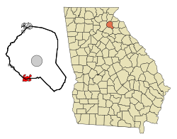
Banks County Georgia Incorporated and Unincorporated areas Maysville Highlighted.svg
Location in Banks County and the state of Georgia
Coordinates: 34°15′20″N83°33′08″W / 34.25556°N 83.55222°W / 34.25556; -83.55222
Country United States
State Georgia
Counties Banks, Jackson
Area
[1]
  Total4.72 sq mi (12.22 km2)
  Land4.66 sq mi (12.06 km2)
  Water0.06 sq mi (0.16 km2)
Elevation
[2]
889 ft (271 m)
Population
 (2020)
  Total1,867
  Density400.99/sq mi (154.83/km2)
Time zone UTC-5 (Eastern (EST))
  Summer (DST) UTC-4 (EDT)
ZIP code
30558
Area code 706
FIPS code 13-50484 [3]
GNIS feature ID2406117 [2]
Website cityofmaysvillega.org

Maysville is a town in Banks and Jackson counties in the U.S. state of Georgia. The population was 1,798 at the 2010 census, [4] up from 1,247 at the 2000 census.

Contents

History

The Georgia General Assembly incorporated Maysville as a town in 1879. [5]

Geography

According to the United States Census Bureau, the town has a total area of 4.3 square miles (11.2 km2), of which 4.2 square miles (11.0 km2) is land and 0.04 square miles (0.1 km2), or 1.27%, is water. [4]

Maysville is 70 miles (110 km) northeast of Atlanta. Towns within 10 miles (16 km) include Commerce, Gillsville, Lula, Jefferson, and Pendergrass. [6]

Climate

Maysville has a humid subtropical climate. The temperature peaks in July with an average high of 90°, but temperatures can get much colder during the winter months. The average low during January was 29°. [7] Maysville has even seen fair amounts of heavier than average snowfall in the past. An example of this occurred in March 2009 when several inches of snow fell across Banks County. [8]

Government

Richard Presley, Mayor of Maysville Richard Presley.jpg
Richard Presley, Mayor of Maysville

The governing legislative authority has two components. A mayor serves as the top executive along with four city council members. [9] The head of the local government is Mayor Richard Presley. [10]

City council

The legislative council serves as governing head, in conjunction with the mayor, over Maysville and its issues. it was established in March 2010 by House Bill 961. [11]

Qualifications

"The members of the city council shall serve for terms of four years and until the respective successors are elected and qualified. The term of office of each member of the city council shall begin on the first day of January immediately following the election of such member unless general law authorizes or requires the term to begin at the first organizational meeting in January or upon some other date. No person shall be eligible to serve as mayor or councilmember unless that person shall have been a resident of the city for 12 months prior to the date of the election of mayor or members of the city council; each shall continue to reside therein during that person´s period of service and to be registered and qualified to vote in municipal elections of this city.The mayor and councilmembers shall be elected by plurality vote as provided in Section 5.13 of this charter." [12]

Council meetings

The city council holds an organizational meeting on the first Monday of January following each election. [13] The meeting is called to order by the city clerk and the oath of office is administered to the newly elected members. [14] Special meetings of the city council may be held should the mayor request them. All councilmembers must be notified personally, or by telephone, at least 48 hours in advance of the meeting. [15]

Map of Maysville's wards Ward Map-06062011Plan MaysvilleWards.jpg
Map of Maysville's wards

Political wards

Maysville is apportioned into four voting wards. Members from the city's council [16] are elected into representing each assigned ward during council meetings.

Demographics

Historical population
CensusPop.Note
1880 116
1890 327181.9%
1900 45338.5%
1910 80577.7%
1920 795−1.2%
1930 619−22.1%
1940 514−17.0%
1950 5333.7%
1960 5533.8%
1970 5530.0%
1980 61911.9%
1990 72817.6%
2000 1,24771.3%
2010 1,79844.2%
2020 1,8673.8%
U.S. Decennial Census [17]

2020 census

In 2020 Maysville had 1,798 people. The population by county breakdown was as follows: 926 in Banks County and 872 in Jackson County. [18]


2010 census

As of the census of 2010, there were 1,798 people, 669 households, and 493 families residing in the town. There were 756 housing units, of which 87, or 11.5%, were vacant. The racial makeup of the city was 93.8% white, 2.2% African American, 0.4% Asian, 1.1% some other race, and 2.4% from two or more races. 2.6% of the population were Hispanic or Latino of any race. [19]

Of the 669 households, 35.9% had children under the age of 18 living with them, 58.7% were headed by married couples living together, 10.6% had a female householder with no husband present, and 26.3% were non-families. 24.1% of all households were made up of individuals, and 12.1% were someone living alone who was 65 years of age or older. The average household size was 2.66, and the average family size was 3.13. [19]

In the town, 25.4% of the population were under the age of 18, 7.9% were from 18 to 24, 26.5% from 25 to 44, 26.7% from 45 to 64, and 13.5% were 65 years of age or older. The median age was 38.4 years. For every 100 females, there were 92.7 males. For every 100 females age 18 and over, there were 88.3 males. [19]

For the period 2012–2016, the estimated median annual income for a household was $37,714, and the median income for a family was $40,313. The per capita income for the town was $18,105. Male full-time workers had a median income of $40,313, versus $33,438 for females. 21.5% of the population and 23.3% of families were below the poverty line. 23.7% of the population under the age of 18 and 14.7% of those 65 or older were living in poverty. [20]

2000 census

As of the census [3] of 2000, there were 1,247 people, 481 households, and 365 families residing in the town. The population density was 346.1 inhabitants per square mile (133.6/km2). There were 529 housing units at an average density of 146.8 per square mile (56.7/km2). The racial makeup of the town was 95.11% White, 2.57% African American, 0.08% Native American, 0.24% Asian, 0.96% from other races, and 1.04% from two or more races. Hispanic or Latino people of any race were 1.52% of the population.

There were 481 households, out of which 35.8% had children under the age of 18 living with them, 61.7% were married couples living together, 9.6% had a female householder with no husband present, and 24.1% were non-families. 21.6% of all households were made up of individuals, and 8.9% had someone living alone who was 65 years of age or older. The average household size was 2.58 and the average family size was 2.99.

In the town, the population was spread out, with 26.3% under the age of 18, 6.9% from 18 to 24, 32.7% from 25 to 44, 22.5% from 45 to 64, and 11.5% who were 65 years of age or older. The median age was 36 years. For every 100 females, there were 93.6 males. For every 100 females age 18 and over, there were 85.3 males.

The median income for a household in the town was $40,714, and the median income for a family was $47,368. Males had a median income of $34,063 versus $24,615 for females. The per capita income for the town was $17,153. About 4.5% of families and 6.6% of the population were below the poverty line, including 3.6% of those under age 18 and 21.4% of those age 65 or over.
Education

The portion in Banks County is in the Banks County School District. [21] Students there are zoned to Banks County High School.

The portion in Jackson County is in the Jackson County School District. [22]

Related Research Articles

<span class="mw-page-title-main">Mason County, Kentucky</span> County in Kentucky, United States

Mason County is a county located in the U.S. state of Kentucky. As of the 2020 census, the population was 17,120. Its county seat is Maysville. The county was created from Bourbon County, Virginia in 1788 and named for George Mason, a Virginia delegate to the U.S. Constitutional Convention known as the "Father of the Bill of Rights". Mason County comprises the Maysville, KY Micropolitan Statistical Area, which is included in the Cincinnati-Wilmington-Maysville, OH-KY-IN Combined Statistical Area.

<span class="mw-page-title-main">Franklin County, Georgia</span> County in Georgia, United States

Franklin County is a county located in the northeastern part of the U.S. state of Georgia. As of the 2020 census, the population was 23,424. The county seat is Carnesville. On February 25, 1784, Franklin and Washington became Georgia's eighth and ninth counties, with Franklin named in honor of patriot Benjamin Franklin.

<span class="mw-page-title-main">Banks County, Georgia</span> County in Georgia, United States

Banks County is a county located in the northeastern part of the U.S. state of Georgia. As of the 2020 census, the population was 18,035, down from 18,395 in 2010. The county seat is Homer. The Old Banks County Courthouse is located in Homer and listed on the National Register of Historic Places. A new county courthouse was constructed adjacent to the old one in 1983.

<span class="mw-page-title-main">Alto, Georgia</span> Town in Georgia, United States

Alto is a town in Banks and Habersham counties in the U.S. state of Georgia. As of the 2010 census, the town had a population of 1,172, up from 876 at the 2000 census.

<span class="mw-page-title-main">Gillsville, Georgia</span> City in Georgia, United States

Gillsville is a city in Banks and Hall counties in the U.S. state of Georgia. The population was 235 at the 2010 census.

<span class="mw-page-title-main">Lula, Georgia</span> City in Georgia, United States

Lula is a city in Hall and Banks counties in the U.S. state of Georgia. Most of the city is in Hall County, with a small eastern portion of the city located in Banks County. The population was 2,822 at the 2020 census. The Hall County portion of Lula is part of the Gainesville, GA Metropolitan Statistical Area. Lula is the home of RailRoad Days, a yearly festival held usually every May. Lula is the railroad junction between the Atlanta northeast line and the Athens north line of Norfolk Southern Railway.

<span class="mw-page-title-main">Bowman, Georgia</span> City in Georgia, United States

Bowman is a city in Elbert County, Georgia, United States. As of the 2020 census, the city had a population of 872.

<span class="mw-page-title-main">Fairmount, Georgia</span> City in Georgia, United States

Fairmount is a city in Gordon County, Georgia, United States. As of the 2010 census it had a population of 720. Gordon County is home to New Echota, which was once the Cherokee Nation's capital. It was the origin of the Cherokee written language and newspaper, the Cherokee Phoenix.

<span class="mw-page-title-main">Hoschton, Georgia</span> City in Georgia, United States

Hoschton is a city in Jackson County, Georgia, United States. The population was 1,377 at the 2010 census. As of 2018 the estimated population was 1,916.

<span class="mw-page-title-main">Talmo, Georgia</span> Town in Georgia, United States

Talmo is a town in Jackson County, Georgia, United States. The population was 257 at the 2020 census.

<span class="mw-page-title-main">Hiawassee, Georgia</span> City in Georgia, United States

Hiawassee is the county seat of Towns County, Georgia, United States. The population was 981 at the 2020 census. Its name is derived from the Cherokee—or perhaps Creek—word Ayuhwasi, which means meadow, Hiawassee is also known in the novel "Restart" by Gordon Korman.

<span class="mw-page-title-main">Maysville, Iowa</span> City in Iowa, United States

Maysville is a city in Scott County, Iowa, United States. The population was 156 at the time of the 2020 census.

<span class="mw-page-title-main">Concord, Kentucky</span> City in Kentucky, United States

Concord is a home rule-class city in Lewis County, Kentucky, in the United States. The population was 19 at the 2020 census, making it the second least populated city in Kentucky after South Park View It is part of the Maysville Micropolitan Statistical Area.

<span class="mw-page-title-main">Dover, Kentucky</span> City in Kentucky, United States

Dover is a home rule-class city in Mason County, Kentucky, United States. The population was 221 at the 2020 census, down from 252 in 2010. It is part of the Maysville Micropolitan Statistical Area.

<span class="mw-page-title-main">Maysville, Missouri</span> City in Missouri, United States

Maysville is a city in DeKalb County, Missouri, United States. The population was 1,095 at the 2020 census. Maysville is the county seat of DeKalb County.

<span class="mw-page-title-main">Maysville, North Carolina</span> Town in North Carolina, United States

Maysville is a town in Jones County, North Carolina, United States. The population was 818 at the 2020 census. It is part of the New Bern, North Carolina Metropolitan Statistical Area. This town was home to former MLB left fielder Louie Meadows.

<span class="mw-page-title-main">New Carlisle, Ohio</span> City in Ohio, United States

New Carlisle is a city in Bethel Township, Clark County, Ohio, United States. The population was 5,559 at the 2020 census. It is part of the Springfield, Ohio Metropolitan Statistical Area.

<span class="mw-page-title-main">Allenport, Washington County, Pennsylvania</span> Borough in Pennsylvania, United States

Allenport is a borough on the Monongahela River in Washington County, Pennsylvania, United States and part of the Pittsburgh metropolitan area since 1950. The population was 483 at the 2020 census.

<span class="mw-page-title-main">Falling Spring, West Virginia</span> Town in West Virginia, United States

Falling Spring is a town in Greenbrier County, West Virginia, United States. It is also known as Renick from the name of its post office. The population was 171 at the 2020 census.

<span class="mw-page-title-main">Germantown, Kentucky</span> City in Kentucky, United States

Germantown is a home rule-class city in Bracken and Mason counties in the U.S. state of Kentucky. The population was 146 at the 2020 census.

References

  1. "2020 U.S. Gazetteer Files". United States Census Bureau. Retrieved December 18, 2021.
  2. 1 2 U.S. Geological Survey Geographic Names Information System: Maysville, Georgia
  3. 1 2 "U.S. Census website". United States Census Bureau . Retrieved January 31, 2008.
  4. 1 2 "Geographic Identifiers: 2010 Demographic Profile Data (G001): Maysville town, Georgia". U.S. Census Bureau, American Factfinder. Archived from the original on February 12, 2020. Retrieved October 29, 2013.
  5. Acts Passed by the General Assembly of Georgia. J. Johnston. 1880. p. 309.
  6. "Maysville, Georgia (GA 30558) profile: population, maps, real estate, averages, homes, statistics, relocation, travel, jobs, hospitals, schools, crime, moving, houses, news, sex offenders". city-data.com.
  7. "Maysville, Georgia Climate". bestplaces.net.
  8. "Wintry Weather". The Banks County News. Vol. 40, no. 14. Mainstreet Newspapers, Inc. March 4, 2009. p. 1A.
  9. "Archived copy" (PDF). Archived from the original (PDF) on July 15, 2014. Retrieved July 7, 2014.{{cite web}}: CS1 maint: archived copy as title (link) | see lines 229-231
  10. "Mayor". City of Maysville. Retrieved July 7, 2014.
  11. http://www.gainesvilletimes.com/archives/31254/ | Date is March 27, 2010
  12. "Archived copy" (PDF). Archived from the original (PDF) on July 15, 2014. Retrieved July 7, 2014.{{cite web}}: CS1 maint: archived copy as title (link) | see lines 237-247
  13. "Archived copy" (PDF). Archived from the original (PDF) on July 15, 2014. Retrieved July 7, 2014.{{cite web}}: CS1 maint: archived copy as title (link) | see lines 343-344
  14. "Archived copy" (PDF). Archived from the original (PDF) on July 15, 2014. Retrieved July 7, 2014.{{cite web}}: CS1 maint: archived copy as title (link) | see lines 346-348
  15. "Archived copy" (PDF). Archived from the original (PDF) on July 15, 2014. Retrieved July 7, 2014.{{cite web}}: CS1 maint: archived copy as title (link) | see lines 353-360
  16. "City Council – City of Maysville, Georgia".
  17. "Census of Population and Housing". Census.gov. Retrieved June 4, 2015.
  18. "General Highway Map Jackson County Georgia" (PDF). Georgia Department of Transportation . Retrieved September 25, 2024.
  19. 1 2 3 "Profile of General Population and Housing Characteristics: 2010 Census Summary File 1 (DP-1): Maysville town, Georgia". American Factfinder. U.S. Census Bureau. Archived from the original on February 13, 2020. Retrieved May 3, 2018.
  20. "Selected Economic Characteristics: 2012-2016 American Community Survey 5-Year Estimates (DP03): Maysville town, Georgia". American Factfinder. U.S. Census Bureau. Archived from the original on February 13, 2020. Retrieved May 3, 2018.
  21. "2020 CENSUS - SCHOOL DISTRICT REFERENCE MAP: Banks County, GA" (PDF). U.S. Census Bureau . Retrieved May 7, 2023. - Text list
  22. "2020 CENSUS - SCHOOL DISTRICT REFERENCE MAP: Jackson County, GA" (PDF). U.S. Census Bureau. p. 5 (PDF p. 6/27). Retrieved May 7, 2023. - Text list