Bull Run or Bullrun may refer to:

The Battle of Cockpit Point, the Battle of Freestone Point, or the Battle of Shipping Point, took place on January 3, 1862, in Prince William County, Virginia, as part of the blockade of the Potomac River during the American Civil War.
The Siege and Battle of Corinth Sites are a National Historic Landmark District encompassing surviving elements of three significant American Civil War engagements in and near Corinth, Mississippi. Included are landscape and battlefield features of the Siege of Corinth, the Second Battle of Corinth, and the lesser Battle of Hatchie's Bridge on October 5, 1862. The district includes features located in both Alcorn County, Mississippi and Hardeman County, Tennessee, with some of the former preserved as part of Shiloh National Military Park. It was designated a landmark in 1991.

Manassas National Battlefield Park, located north of Manassas, in Prince William County, Virginia, preserves the site of two major American Civil War battles: the First Battle of Bull Run on July 21, 1861, and the Second Battle of Bull Run which was fought between August 28 and August 30, 1862. The peaceful Virginia countryside bore witness to clashes between the armies of the North (Union) and the South (Confederacy), and it was there that Confederate General Thomas J. Jackson acquired his nickname "Stonewall."

Aldie is an unincorporated community located between Chantilly and Middleburg in Loudoun County, Virginia. Aldie's historic heart is the Village of Aldie that is located on the John Mosby Highway in a gap between the Catoctin Mountains and Bull Run Mountains, through which the Little River flows. Aldie traditionally serves as the gateway to Loudoun Valley and beyond.

Buildings, sites, districts, and objects in Virginia listed on the National Register of Historic Places:

Fort Ethan Allen was an earthwork fortification that the Union Army built in 1861 on the property of Gilbert Vanderwerken in Alexandria County, Virginia, as part of the Civil War defenses of Washington. The remains of the fort are now within Arlington County's Fort Ethan Allen Park.

Hume is an unincorporated community in Fauquier County, Virginia. Hume is five miles south of Interstate 66's Exit 18 and is named for the local Hume family. It runs along Virginia State Route 688. It is east of the Rappahannock County line. The community has a post office and ZIP Code of 22639, and is home to a local winery.

Leesylvania State Park is located in the southeastern part of Prince William County, Virginia. The land was donated in 1978 by philanthropist Daniel K. Ludwig, and the park was dedicated in 1985 and opened full-time in 1992.

The Centreville Military Railroad was a 5.5-mile (8.9 km) spur running from the Orange and Alexandria Railroad east of Manassas Junction across Bull Run and up the south side of the Centreville Plateau. Built by the Confederate States Army between November 1861 and February 1862, it was the first exclusively military railroad. Ultimately, the Centreville Military Railroad reached a point near a modern McDonald's restaurant on Virginia State Route 28, south of the modern junction with U.S. Route 29 in Virginia.
The 4th Virginia Volunteer Cavalry Regiment was a cavalry regiment raised in Virginia for service in the Confederate States Army during the American Civil War. It fought mostly with the Army of Northern Virginia.

The Manassas Campaign was a series of military engagements in the Eastern Theater of the American Civil War.

Evergreen, also known as Evergreen Plantation Manor House, is a historic plantation house located near Haymarket, Prince William County, Virginia. It is known for its association with Edmund Berkeley (1824-1915), one of four brothers who led the 8th Virginia Infantry during the American Civil War and who later became a local philanthropist and led many veterans' peace and commemorative activities.
The Orange and Alexandria Railroad Bridge Piers are the historical remains of a bridge that carried the Orange and Alexandria Railroad across Bull Run between Fairfax and Prince William Counties, Virginia. The railroad, and this bridge location in particular, were of strategic interest to both Union and Confederate forces during the American Civil War. The bridge was rebuilt at least seven times during the war years. The piers are located just south of a modern railroad bridge.

The Mayfield Fortification is a historic American Civil War earthworks at 8401 Quarry Road in Manassas, Virginia. It is one of a series of fortifications constructed by the Confederate Army to defend the critical Manassas railroad junction in 1861. The fort consisted of earthworks with log revetments, and was built by local Confederate troops and slave labor. After 1862 the fort was sporadically occupied by Union forces.
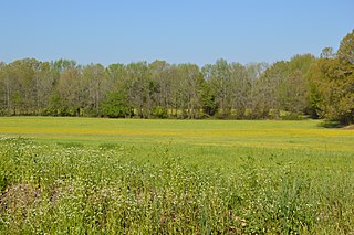
The Little River Rural Historic District encompasses a large rural landscape in northeastern Fauquier County. Covering some 23,000 acres (9,300 ha), the district extends from near The Plains in the south to near Middleburg in the north. On the east it is bounded by the Bull Run Mountains, and on the west by Cromwell's Run. The area's landscape typifies the characteristics of the Piedmont region of Virginia, and is devoid of high-density residential, commercial, or industrial activity. Land use is largely devoted to agricultural, equestrian, and hunting pursuits. There are a few places where mills historically operated, and there are three small village centers in the district. A portion of the Middleburg battlefield lies in the northern part of the district, and the district encompasses several previously listed areas, including the Burrland Farm Historic District, the Gen. William Mitchell House, the Waverly house, Old Denton, and Green Pastures.
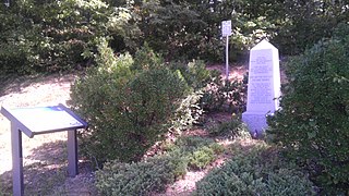
Signal Hill is a historic Confederate Army military site in Prince William County, Virginia. It is from this location, a signal station atop the hill, that Confederate observers in 1861 spotted Union Army troops attempting to cross Sudley Ford. The Confederate response to this maneuver began the First Battle of Bull Run.

The Broad Run–Little Georgetown Rural Historic District encompasses a large rural landscape in northeastern Fauquier County, Virginia, and a small portion of neighboring Prince William County, Virginia. The district covers about 9,500 acres (3,800 ha) of rolling hills, that has an agricultural history dating to the 18th century. It is roughly divided by the John Marshall Highway, and is bounded on the west by The Plains, the east by the Bull Run Mountains, and the south by Pignut Mountain.


