
The Fan is a district of Richmond, Virginia, so named because of the "fan" shape of the array of streets that extend west from Belvidere Street, on the eastern edge of Monroe Park, westward to Arthur Ashe Boulevard. However, the streets rapidly resemble a grid after they go through what is now Virginia Commonwealth University. The Fan is one of the easterly points of the city's West End section, and is bordered to the north by Broad Street and to the south by VA 195, although the Fan District Association considers the southern border to be the properties abutting the south side of Main Street. The western side is sometimes called the Upper Fan and the eastern side the Lower Fan, though confusingly the Uptown district is located near VCU in the Lower Fan. Many cafes and locally owned restaurants are located here, as well as historic Monument Avenue, a boulevard formerly featuring statuary of the Civil War's Confederate president and generals. The only current statue is a more modern one of tennis icon Arthur Ashe. Development of the Fan district was strongly influenced by the City Beautiful movement of the late 19th century.

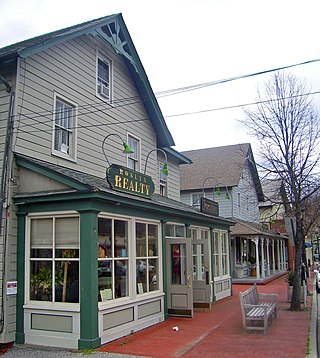
The Main Street Historic District encompasses the historic commercial center of Middletown, Connecticut, United States. Middletown was one of the most important ports on the Connecticut River during the colonial period, and Main Street "has been the center of community life since the earliest period of settlement". Today Main Street is home to a number of 19th century buildings, maintaining the bulk of its historic character. It was listed on the National Register of Historic Places in 1983.

The Sycamore Historic District is a meandering area encompassing 99 acres (400,000 m2) of the land in and around the downtown of the DeKalb County, Illinois county seat, Sycamore. The area includes historic buildings and a number of historical and Victorian homes. Some significant structures are among those located within the Historic District including the DeKalb County Courthouse and the Sycamore Public Library. The district has been listed on the National Register of Historic Places since May 2, 1978.

The Galena Historic District is a historic district located in the city of Galena, Illinois, United States. The historic district encompasses 85 percent of the city of Galena and includes more than 800 properties. The downtown area consists of three successive tiers made up of Main, Bench and Prospect Streets. Within the boundaries of the district are such notable homes as the Ulysses S. Grant Home and the Elihu B. Washburne House. The Galena Historic District was added to the U.S. National Register of Historic Places in 1969.
The Roslyn Village Historic District encompasses the center of that village in the U.S. state of New York. It includes within its boundaries the earlier Main Street Historic District, although that is considered a separate district by the National Park Service, which added the Roslyn Village district to the National Register of Historic Places in 1987.

The Fort Madison Downtown Commercial Historic District has a collection of late-19th century store fronts centered on Ave. G, from 6th to 9th Street, and Ave. H from 7th to 9th, in Fort Madison, Iowa. It was listed on the National Register of Historic Places in 2007.

There are nine historic districts in Meridian, Mississippi. Each of these districts is listed on the National Register of Historic Places. One district, Meridian Downtown Historic District, is a combination of two older districts, Meridian Urban Center Historic District and Union Station Historic District. Many architectural styles are present in the districts, most from the late 19th century and early 20th century, including Queen Anne, Colonial Revival, Italianate, Art Deco, Late Victorian, and Bungalow.
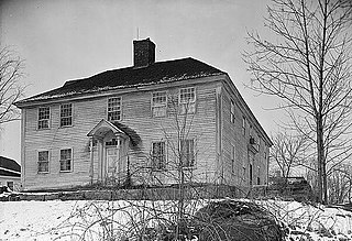
The North Stonington Village Historic District is a 105-acre (42 ha) historic district encompassing the historic center of the main village of North Stonington, Connecticut. The district includes a well-preserved small industrial village, which flourished in the years before the American Civil War, and declined afterward. The district was listed on the National Register of Historic Places in 1983.
The Enfield Village Historic District encompasses the historic 19th century village center of Enfield, New Hampshire. The district was listed on the National Register of Historic Places in 2010. Multiple buildings of the district were added to the New Hampshire State Register of Historic Places in 2012.

The Rochester Commercial and Industrial District encompasses the civic, commercial, and industrial heart of Rochester, New Hampshire. Oriented around the city's Central Square, the 6-acre (2.4 ha) district includes the city's major civic buildings, most of which are Classical Revival structures from the early 20th century, a number of commercial buildings dating as far back as the square's formation in the 1820s, and several late 19th-century industrial facilities. The district extends primarily along Main Street, from Bridge and Union Streets to Winter and Academy Streets, and includes properties extending along Wakefield and Hanson Streets, as well as other adjacent streets. The district was listed on the National Register of Historic Places in 1983.

The Downtown Bennington Historic District encompasses the historic commercial heart of Bennington, Vermont. Centered on the junction of Main, South, and North Streets, it exhibits a variety of commercial architectural styles from the early 19th to mid-20th century. It was listed on the National Register of Historic Places in 1980, and was enlarged in 2008.

The Danby Village Historic District encompasses much of the town center of Danby, Vermont. It is centered on a stretch of Main Street, roughly between Depot Street and Brook Road. The village has a cohesive collection of mid-19th century architecture, mostly residential, with a modest number of later additions. The district was listed on the National Register of Historic Places in 1983.

The Wallingford Main Street Historic District encompasses the historic portions of the village of Wallingford, Vermont. An essentially linear district extending along Main Street on either side of School Street, it has a well-preserved array of 19th and early-20th century residential, commercial, and civic buildings. It was listed on the National Register of Historic Places in 1984.

The Waterville Main Street Historic District encompasses the best-preserved portions of the historical commercial downtown area of Waterville, Maine. Developed most intensively in the late 19th and early 20th centuries, this area was the center of commerce for Waterville and the surrounding rural communities. It encompasses 25 properties on Main and Common Streets, including the Waterville Opera House and City Hall. It was listed on the National Register of Historic Places in 2012, and was slightly enlarged in 2016.

The Plainfield Village Historic District encompasses a significant portion of the village of Plainfield, Vermont. Located in northernmost Plainfield on United States Route 2, the village grew in the 19th century as a mill town and service community for the surround agricultural areas, and has a well-preserved collection of Greek Revival and Italianate architecture. It was listed on the National Register of Historic Places in 1983.

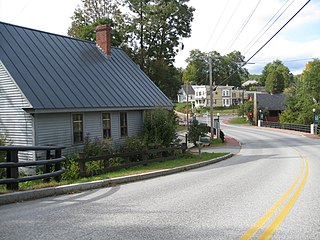
The Jeffersonville Historic District encompasses a significant portion of the village of Jeffersonville, the largest in the town of Cambridge, Vermont. The village, long the town's commercial heart, has a well-preserved array of 19th and early-20th century architecture. It was listed on the National Register of Historic Places in 1987.

The St. Johnsbury Historic District encompasses much of the historic civic and commercial center of St. Johnsbury, Vermont. Representing a significant expansion of the Railroad Street Historic District and the St. Johnsbury Main Street Historic District, it captures the historical tension and competition between Main Street and Railroad Street for primacy as the town's most important civic and commercial areas. The district was listed on the National Register of Historic Places in 1980.
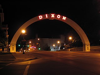
The Dixon Downtown Historic District is a historic district which encompasses 154 properties in downtown Dixon, Illinois. The district includes the city's commercial core, which includes buildings dating back to the 1850s. Dixon's commercial buildings are largely two-story brick structures and reflect the popular architectural styles of their era of construction; the Italianate style is most common in 19th-century buildings, while the Commercial style and revival styles such as Neoclassical and Beaux-Arts became popular after 1900. Many of Dixon's prominent government and community buildings also lie within the district, including the Lee County Courthouse, City Hall, its current and former post offices, and several churches. A residential section on the west side of the district includes Queen Anne and Craftsman style homes; the former style was popular in the late 19th century, while the latter was popular in the early 20th.

The Ottawa Commercial Historic District is a historic district in downtown Ottawa, Illinois. The district includes 195 buildings and structures, most of them commercial buildings, spread out over 26 city blocks. The oldest buildings in the district, located near the Illinois and Fox rivers, were built in the 1830s. The district expanded northward toward the Illinois & Michigan Canal over time, and the buildings in its northern half date to the mid-to-late 19th and early 20th centuries. The district's buildings include most popular Midwestern architectural styles from the mid-19th century through the mid-20th century; some of the most common are vernacular frame buildings from the early years of the district's growth, Italianate buildings from the mid-19th century, Commercial style buildings from the early 20th century, and International Style buildings from the mid-20th century.

The Elgin Downtown Commercial District is a historic district encompassing the commercial core of downtown Elgin, Illinois. The district includes 94 buildings, 76 of which are considered contributing buildings to its historic character. While development in downtown Elgin began in the 1830s, the oldest buildings in the district were built in the 1870s; most of the district's buildings were built in the late 19th and early 20th centuries, but its development continued through the 20th century. The majority of the buildings in the district are two- and three-story commercial buildings, but it also includes several taller commercial buildings, churches, a public library, and a power station. Most of the 19th-century buildings in the district have Italianate or Queen Anne designs, while the 20th-century buildings features styles such as Colonial Revival and Renaissance Revival.


