Musi River (India)

Last updated

Musi (Muchukunda) River
Muchukunda
View of Musi river from Nayapul.jpg
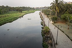
Musi river seen from Nayapul bridge in Hyderabad
Location
State Telangana
OriginAnanthagiri Hills, Vikarabad
Basin features
Bridges Purana Pul
Naya Pul

The Musi River is a major tributary of the Krishna River in the Deccan Plateau, flowing through Telangana, India. The river's historical name is Muchukunda. Hyderabad stands on the banks of the Musi River, which divides the historic Old City from the new city. The Musi River flows into Himayat Sagar and Osman Sagar, which are artificial lakes that act as reservoirs that once supplied the twin cities of Hyderabad and Secunderabad with drinking water. It originates in the Ananthagiri Hills, near Vikarabad. It generally flows towards the east, turning south at Chittaloor. It flows into the Krishna River at Vadapally near Miryalaguda in Nalgonda district.

Contents

Places of interest

Floods

SC - GHY Special (28140164286).jpg
Railway bridge over Musi river

The Musi river was the cause of frequent flood devastation of Hyderabad city until the early decades of the 20th century. On 28 September 1908, Hyderabad was flooded, which included 17 inches of rain in one day, killing around 15,000 people. [1]

Musi River is a tributary of the Krishna River in the Deccan Plateau Krishna River basin map.svg
Musi River is a tributary of the Krishna River in the Deccan Plateau

The modern era of the development of the twin cities began soon after these floods in 1908. This necessitated planned, phased development. [2] [3]

Abdallah Ahmed Bin Mahfooz submitted his report on 1 October 1909, with recommendations on preventing a recurrence of floods and improving civic amenities. However, there are conflicting reports that Sir M. Visvesvaraya was engaged by the erstwhile Nizam to help design the drainage system and prevent floods. Nizam VII constituted a City Improve Trust in 1912. He built a flood control system on the river. A dam was built in 1920 across the river, ten miles (16  km) upstream from the city called Osman Sagar. In 1927 another reservoir was built on Esi (a tributary of Musi) and named Himayat Sagar. These lakes prevented the flooding of the River Musi and are major drinking water sources for Hyderabad city. [3] [4]

Pollution

In 2022, the Musi river was the 22nd most polluted river in the world. [5]

References and notes

  1. Ifthekhar, J.S (28 September 2012). "Remembering the deluge of 1908". The Hindu. Retrieved 30 September 2012.
  2. Murali, D (22 April 2006). "Floods proved a blessing in disguise". The Hindu . Archived from the original on 8 November 2012. Retrieved 17 July 2012.
  3. 1 2 Shahid, Sajjad (30 September 2012). "Sitamber: the harbinger of torment". The Times of India . Archived from the original on 9 August 2013. Retrieved 30 September 2012.
  4. "Chequered past". The Hindu. 11 February 2004. Archived from the original on 17 January 2010. Retrieved 29 April 2015.
  5. Akbar, Syed (17 May 2022). "Lifeline Musi 22nd most toxic river in the world, virtual drug lab". The Times of India . Retrieved 21 February 2023.

17°22′N78°28′E / 17.367°N 78.467°E / 17.367; 78.467

Related Research Articles

<span class="mw-page-title-main">Krishna River</span> River in southern India

The Krishna River in the Deccan plateau is the third-longest river in India, after the Ganges and Godavari. It is also the fourth-largest in terms of water inflows and river basin area in India, after the Ganges, Indus and Godavari. The river, also called Krishnaveni, is 1,400 kilometres (870 mi) long and its length in Maharashtra is 282 kilometres. It is a major source of irrigation in the Indian states of Maharashtra, Karnataka, Telangana and Andhra Pradesh.

<span class="mw-page-title-main">Hyderabad State</span> Princely state in southern India (1724–1948)

Hyderabad State was a princely state in the south-central Deccan region of India with its capital at the city of Hyderabad. It is now divided into the present-day state of Telangana, the Kalyana-Karnataka region of Karnataka, and the Marathwada region of Maharashtra in India.

<span class="mw-page-title-main">Osman Sagar</span> Dam in Telangana, India

Osman Sagar is a reservoir in the Indian city of Hyderabad. The lake is around 46 km2, and the reservoir is around 29 km2, with total level of 1,790 feet and a capacity of 3.9 tmc ft.

<span class="mw-page-title-main">Mir Osman Ali Khan</span> Last and 7th Nizam of Hyderabad, 1911–1948

Osman Ali Khan, Asaf Jah VII was the last Nizam (ruler) of Hyderabad State, the largest state in the erstwhile British Indian Empire. He ascended the throne on 29 August 1911, at the age of 25 and ruled the State of Hyderabad between 1911 and 1948, until the Indian Union annexed it. He was styled as His Exalted Highness (H.E.H) the Nizam of Hyderabad, and was widely considered one of the world's wealthiest people of all time. With some estimates placing his wealth at 2% of U.S. GDP, his portrait was on the cover of Time magazine in 1937. As a semi-autonomous monarch, he had his mint, printing his currency, the Hyderabadi rupee, and had a private treasury that was said to contain £100 million in gold and silver bullion, and a further £400 million of jewels. The major source of his wealth was the Golconda mines, the only supplier of diamonds in the world at that time. Among them was the Jacob Diamond, valued at some £50 million, and used by the Nizam as a paperweight.

<span class="mw-page-title-main">Nizam Sagar Dam</span> Dam in Telangana, India

Nizam Sagar Dam is an Indian dam named after the Nizam of Hyderabad. It is a reservoir constructed across the Manjira River, a tributary of the Godavari River, between Achampet and BanjePally villages of the Kamareddy district in Telangana, India. It is located at about 144 km (89 mi) north-west of Hyderabad. Nizam Sagar is the oldest dam in the state of Telangana.

<span class="mw-page-title-main">Sriram Sagar Project</span> Dam in Telangana, India

The Sriram Sagar Project is also known as the Pochampadu Project is an Indian flood-flow project on the Godavari. The Project is located in Nizamabad district, 3 km away from National Highway 44. It has been described by The Hindu as a "lifeline for a large part of Telangana".

<span class="mw-page-title-main">Ranga Reddy district</span> District of Telangana in India

Ranga Reddy district is a district in the Indian state of Telangana. The district headquarters is located at Kongara Kalan Village, Ibrahimpatnam Mandal,. The district was named after the former deputy chief minister of the United Andhra Pradesh, K. V. Ranga Reddy. The district shares boundaries with Nalgonda, Yadadri Bhuvanagiri, Hyderabad, Medchal–Malkajgiri, Nagarkurnool, Mahabubnagar, Sangareddy and Vikarabad districts.

<span class="mw-page-title-main">Nagarjuna Sagar Dam</span> Dam in Andhra Pradesh & Nalgonda district, Telangana

Nagarjuna Sagar Dam is a masonry dam across the Krishna River at Nagarjuna Sagar which straddles the border between Palnadu district in Andhra Pradesh and Nalgonda district in Telangana. The dam provides irrigation water to the districts of Krishna, Guntur, Palnadu, Prakasam and parts of West Godavari districts of Andhra Pradesh and also Nalgonda, Suryapet, Khammam, Bhadradri Kothagudem districts of Telangana. It is also a source of electricity generation for the national grid.

<span class="mw-page-title-main">Himayat Sagar</span> Dam in Telangana, India

Himayat Sagar is an artificial lake about 20 kilometres (12 mi) from Hyderabad in the Ranga Reddy district of Telangana, India. It lies parallel to a larger artificial lake called Osman Sagar. The storage capacity of the reservoir is 2.9 tmc ft.

Mir Alam Tank is a reservoir in Hyderabad, Telangana, India. It is located to the south of Musi river. It was the primary source of drinking water to Hyderabad before Osman Sagar and Himayat Sagar were built. It is connected to National Highway 7, near Palm Valley (Tadbun).

<span class="mw-page-title-main">Geography of Hyderabad</span>

Hyderabad is located in central Telangana and is spread over an area of 2,500 km2. The city lies in the Deccan Plateau and rises to an average height of 536 m above the sea level. The city lies at 17.366° N latitude and 78.476° E longitude.

<span class="mw-page-title-main">Hussain Sagar</span> Heart-shaped lake in Hyderabad, Telangana, India

Hussain Sagar is a heart-shaped lake in Hyderabad, Telangana, India, built by Ibrahim Quli Qutb Shah in 1563. It is spread across an area of 5.7 square kilometres (2.2 sq mi) and is fed by the River Musi. A large monolithic statue of the Gautama Buddha, erected in 1992, stands on Gibraltar Rock in the middle of the lake. The lake separates the city centre of Hyderabad from the neighbourhood of Secunderabad. The maximum depth of the lake is 32 feet (9.8 m).

Manchirevula is a village and panchayat. It falls under Gandipet mandal in Ranga Reddy district, Telangana, India. This village falls within the 10 miles radius of Hyderabad city. Some facilities of the Telangana State Police Academy are located in southern Manchirevula.

Fox Sagar Lake, also Jeedimetla Cheruvu or Kolla Cheruvu, is a manmade lake. It is the largest waterbody in Secunderabad. It was once spread over an area of 290 acres (1.2 km2). As of 2014, due to encroachment, it only occupied a surface area of 126 acres (0.51 km2). The lake which is located Jeedimetla near Kompally was built in 1897 by Mahbub Ali Khan, Asaf Jah VI and as per some sources the lake occupies a surface area of 2 square kilometres and some sources claim that it is the second biggest lake in Hyderabad and was a popular spot for picnics. About 1014 illegal structures which have encroached the lake were identified by Telangana Irrigation Department in a report submitted to the National Green Tribunal in November 2022 and this makes Fox Sagar Lake as the third most encroached lake in Hyderabad.

<span class="mw-page-title-main">Ananthagiri Hills, Vikarabad district</span> Hills in Telangana, India

Ananthagiri Hills is located in Vikarabad district, Telangana, India. The water flows from these hills to Osman Sagar, also known as Gandipet lake, and Himayathsagar.

<span class="mw-page-title-main">Great Musi Flood of 1908</span> 1908 natural disaster in India

The Great Musi Flood was a devastating flood that occurred on 28 September 1908 in Hyderabad on the banks of the Musi River. The city of Hyderabad was the capital of the Hyderabad State, ruled by the Nizam, Mir Mahbub Ali Khan.

Hyderabad is the capital of the Indian state of Telangana. It is a historic city noted for its many monuments, temples, mosques and bazaars. A multitude of influences have shaped the character of the city in the last 400 years.

The Telangana Housing Board, formally known as City Improvement Board, is a public sector corporation under the Government of Telangana located in Hyderabad, Telangana. Its activities are to facilitate affordable housing to the citizens of Telangana. The board, which was formerly known as City Improvement Board until 1960, was conceived by Nizam Osman Ali Khan, Asaf Jah VII in 1911.

<span class="mw-page-title-main">2020 Hyderabad floods</span> Heavy rains resulting in flash flooding in Hyderabad, India

The 2020 Hyderabad floods were a series of floods associated with Deep Depression BOB 02 that caused extensive damage and loss of life as a result of flash flooding in Hyderabad, India in October 2020. Among the most affected areas were Balapur, Peerzadiguda, L. B. Nagar, parts of Old City such as Hafiz Baba Nagar, Al Jubail Colony, Omer colony, Osman Nagar, Nabeel Colony, Falaknuma, Chaderghat etc. The fourth tropical cyclone and third deep depression of the 2020 North Indian Ocean cyclone season, BOB 02 formed on 11 October over the west-central Bay of Bengal and slowly drifted towards the east coast of India over the following three days.