
Ivoryton is one of three villages in Essex, Connecticut in Middlesex County. Ivoryton Historic District, the historic district in the village, was listed on the National Register of Historic Places on April 15, 2014.

The Danielson Main Street Historic District encompasses the historic late 19th-century commercial business district of the borough of Danielson in the town of Killingly, Connecticut. It extends along Main Street, between the Five Mile River and Spring Street, including a few buildings on adjacent side streets, representing the area's growth as a commercial and civic center in the late 19th and early 20th centuries. It was listed on the National Register of Historic Places in 1992.

The Clinton Village Historic District encompasses the historic portion of the town center of Clinton, Connecticut. It is roughly linear and extends along East Main Street from the Indian River in the west to Old Post Road in the east. The area represents a well-preserved mid-19th century town center, with architecture dating from the late 17th to mid-20th centuries. The district was listed on the National Register of Historic Places in 1994.

The Georgetown Historic District is a historic district which covers the central portion the village of Georgetown, Connecticut. The district includes parts of Georgetown in the towns of Redding and Wilton and consists of the former Gilbert & Bennett manufacturing plant, institutional housing built for the plant workers, and other private homes.

The Southport Historic District in the town of Fairfield, Connecticut is a 225-acre (91 ha) area historic district that was listed on the National Register of Historic Places in 1971. It preserves a portion of the modern neighborhood and former borough of Southport, Connecticut. Since the British burnt almost all of Southport's structures in 1779, there is only one home built prior to that date, the Meeker House at 824 Harbor Road, which survives.

The Wilton Center Historic District in the town center area of Wilton, Connecticut, was established as a town historic district in 1970 and was listed on the National Register of Historic Places in 1992.

This is a list of National Register of Historic Places listings in New Haven, Connecticut.

The Downtown Norwich Historic District is a historic district representing the core of the downtown area of the city of Norwich, Connecticut in the United States. It was listed on the National Register of Historic Places in 1985. It includes 115 contributing buildings and one other contributing structure over a 64-acre (26 ha) area. Several buildings in the historic district are also individually listed on the National Register, including the Norwich Town Hall, the Telephone Exchange Building and the Carroll Building.
The North Stonington Village Historic District is a 105-acre (42 ha) historic district encompassing the historic center of the main village of North Stonington, Connecticut. The district includes a well-preserved small industrial village, which flourished in the years before the American Civil War, and declined afterward. The district was listed on the National Register of Historic Places in 1983.

The Chapel Street Historic District is a 23-acre (9.3 ha) historic district in the Downtown New Haven area of the city of New Haven, Connecticut. It was listed on the National Register of Historic Places in 1984. The district covers the southwestern corner of Downtown New Haven, including properties from Park Street to Temple Street between Chapel and Crown streets, and properties from High Street to Temple Street between George and Crown streets. It is bordered on the north by the New Haven Green and the Yale University campus. The western edge borders the Dwight Street Historic District. The eastern and southern edges of the district abut areas of more modern development.
The Upper State Street Historic District encompasses a well-preserved neighborhood commercial district of the late 19th century in the East Rock neighborhood of New Haven, Connecticut. The district is an irregular strip running NNE to SSW mainly along State Street in New Haven, one block west of Interstate 91, the highway which determines the district's eastern and southern borders. The district was listed on the U.S. National Register of Historic Places in 1984.

The Boston Post Road Historic District in Darien, Connecticut is a historic district that was listed on the National Register of Historic Places in 1982. At that time, it included 26 structures, of which 23 were contributing buildings. The district is defined by the First Congregational Church and the old town hall building, which was originally built as a school, and connected by the modern Boston Post Road when it was originally laid out in 1806. It also includes a row of 12 nineteenth-century houses and additional properties on Brookside Road and on Old Kings Highway including the Bates-Scofield House built in 1736 and used as an office by the Darien Historical Society.
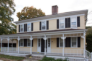
The Marvin Tavern, also known as Matthew Marvin House, is a historic house at 405 Danbury Road in Wilton, Connecticut. It is a 2-1/2 story wood frame structure, with a hip roof and a large central chimney. Although it was built c. 1760, its most prominent feature is its porch, added c. 1880, which features turned posts, a spindled frieze, and decorative jigsawn brackets. It is also of interest to architectural historians for a number of features, including its flared eaves, which are rare in the region before the 19th century.
This is a list of the properties and historic districts in Stamford, Connecticut that are listed on the National Register of Historic Places. The locations of National Register properties and districts for which the latitude and longitude coordinates are included below, may be seen in a Google map.

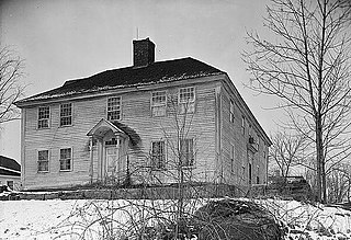
The John Whittlesey Jr. House is a historic house at 40 Ferry Road in Old Saybrook, Connecticut. With a construction history estimated to date to the 1690s, it includes in its structure one of Connecticut's oldest surviving buildings. It was listed on the National Register of Historic Places in 1984.

The Glastonbury Historic District encompasses a streetscape dating to the 17th century, along Main St. from Hebron Ave. to Talcott Rd. in Glastonbury, Connecticut. In addition to a significant number of 17th and 18th-century houses, it shows the architectural development of the town over time, with buildings spanning three centuries in construction dates. It was listed on the National Register of Historic Places in 1984.
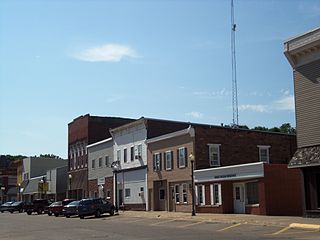
The Wilton Commercial Historic District is a nationally recognized historic district located in Wilton, Iowa, United States. It was listed on the National Register of Historic Places in 2016. At the time of its nomination it consisted of 47 resources, which included 32 contributing buildings, one contributing structure and 14 non-contributing buildings. Wilton got its start when the Mississippi and Missouri Railroad, later the Chicago, Rock Island and Pacific, was surveyed through this area in 1853. It was named for Wilton, Maine, the hometown of one of the founders.

The Cedar Rapids Central Business District Commercial Historic District is a nationally recognized historic district located in Cedar Rapids, Iowa, United States. It was listed on the National Register of Historic Places in 2015. At the time of its nomination it consisted of 60 resources, which included 46 contributing buildings, one contributing structure, 12 non-contributing buildings, and one non-contributing structure. Cedar Rapids was platted on the east bank of the Cedar River as Rapids City in 1841, and it was incorporated under the same name in 1849. Kingston was established on the west bank of the river in 1852. The two smaller communities consolidated in 1870 as Cedar Rapids. The streets were laid out parallel and perpendicular to the river, which flowed from the northwest to the southeast. The Chicago, Iowa and Nebraska Railroad was the first to arrive in the community in 1859 and the tracks were laid on Fourth Street on the eastern edge of the central business district. The first bridge across the river was built at Third Avenue in 1871.

The Downtown Seymour Historic District encompasses most of the historic downtown of Seymour, Connecticut. Sandwiched between Connecticut Route 8 and the tracks of the former Naugatuck Railroad line, now the Waterbury Branch, it developed in the mid-19th century as a successful industrial center dominated by the production of brass goods. The district was listed on the National Register of Historic Places in 1983.


