This is a list of the National Register of Historic Places listings in Itasca County, Minnesota. It is intended to be a complete list of the properties and districts on the National Register of Historic Places in Itasca County, Minnesota, United States. The locations of National Register properties and districts for which the latitude and longitude coordinates are included below, may be seen in an online map.
There are 20 properties and districts listed on the National Register in the county. A supplementary list includes one additional site that was formerly listed on the National Register.
This National Park Service list is complete through NPS recent listings posted August 18, 2023. [1]
[2] | Name on the Register | Image | Date listed [3] | Location | City or town | Description |
---|---|---|---|---|---|---|
1 | Bigfork Village Hall | October 17, 2012 (#12000871) | 200 Main Ave. 47°44′38″N93°39′17″W / 47.744009°N 93.654826°W | Bigfork | Fieldstone municipal hall built in 1936 with Works Progress Administration funds to provide a much-needed government and community center. [4] | |
2 | Bovey Village Hall | August 15, 1991 (#91001059) | 402 2nd St. 47°17′43″N93°24′58″W / 47.2952°N 93.415986°W | Bovey | Well-preserved example of a municipal hall built with federal assistance during the Great Depression, constructed 1934–5. Further noted as one of Minnesota's first Public Works Administration projects and for its eclectic period revival architecture. [5] | |
3 | Canisteo District General Office Building | April 22, 1982 (#82002970) | 200 Cole Ave. 47°17′11″N93°25′26″W / 47.286402°N 93.42399°W | Coleraine | 1908 brick office building, representative of mining company towns throughout the Mesabi Range. [6] Demolished in the summer of 2013 by the City of Coleraine and the Greenway School District. | |
4 | Central School | August 16, 1977 (#77000746) | 10 NW 5th St. 47°14′11″N93°31′45″W / 47.236427°N 93.529122°W | Grand Rapids | Landmark Richardsonian Romanesque school in use for 77 years, one of the first high schools in northern Minnesota outside of Duluth upon its completion in 1895, and one of the only intact 19th-century buildings remaining in Grand Rapids. [7] | |
5 | Church of the Good Shepherd | August 11, 1980 (#80002081) | Off U.S. Route 169 47°17′14″N93°25′46″W / 47.287224°N 93.429456°W | Coleraine | Finely crafted log church built in 1908 by U.S. Steel as a religious and social center for its managerial class, reflecting the strict social hierarchy maintained by the mining companies and the lavish support for those in the upper ranks. [8] | |
6 | Coleraine Carnegie Library | July 17, 1980 (#80002080) | Clemson and Cole Aves., S. 47°17′14″N93°25′28″W / 47.287195°N 93.424317°W | Coleraine | Carnegie library built in Neoclassical style in 1912 to educate and acculturate immigrant mine workers and their families, emblematic of the corporate paternalism of the region's iron mining companies. [9] | |
7 | Coleraine City Hall | June 18, 1992 (#92000800) | 302 Roosevelt Ave. 47°17′19″N93°25′30″W / 47.288476°N 93.42502°W | Coleraine | Renaissance Revival municipal hall built in 1910 to house Coleraine's government offices, fire department, jail, and auditorium as the community evolved from a mining company town to an incorporated village. [10] | |
8 | Coleraine Methodist Episcopal Church | April 22, 1982 (#82002971) | NW. Gayley and Cole Aves. 47°17′14″N93°25′41″W / 47.287144°N 93.428013°W | Coleraine | Largest church on the western Mesabi Range, built 1908–9 with a lower-level YMCA. Significant as a major example of Shingle style architecture in northern Minnesota and a key element of the planned community of Coleraine. [11] | |
9 | General Superintendent's House | April 22, 1982 (#82002972) | Cole Ave. 47°17′11″N93°25′22″W / 47.286507°N 93.422821°W | Coleraine | Large 1911 frame house representative of mining company housing for managers. [6] | |
10 | Frank Gran Farmstead | April 22, 1982 (#82002969) | County Highway 10 47°12′22″N93°18′21″W / 47.206111°N 93.305833°W | La Prairie vicinity | Early-20th-century farm of a prosperous Finnish immigrant, representing Itasca County's few substantial agricultural operations in a post-logging region more characterized by subsistence farms. [12] | |
11 | Hartley Sugar Camp | April 22, 1982 (#82002973) | Off County Highway 10 47°15′39″N93°23′55″W / 47.260833°N 93.398611°W | Bovey vicinity | Maple syruping complex with four log buildings constructed 1904–5 and a lodge built in 1909, a unique example of the hobby farms established by the era's wealthy Minnesotans. [13] | |
12 | Hill Annex Mine | August 1, 1986 (#86002126) | Off U.S. Route 169 47°19′51″N93°16′26″W / 47.33097°N 93.273754°W | Calumet vicinity | Open-pit iron mine complex established in 1912, one of the most productive on the Mesabi Range, whose surviving buildings illustrate the early mining process. [14] Now a state park. [15] | |
13 | Marcell Ranger Station | May 19, 1994 (#94000473) | Minnesota Highway 38 in Chippewa National Forest 47°35′46″N93°41′14″W / 47.596053°N 93.687345°W | Marcell Township | Well-preserved U.S. Forest Service administrative complex with five log structures built 1934–35, noted for its association with the expansion and development of Chippewa National Forest during the New Deal and for its fine National Park Service rustic architecture. [16] | |
14 | Old Cut Foot Sioux Ranger Station | August 7, 1974 (#74001026) | Hatchery Rd. in Chippewa National Forest 47°30′56″N94°02′02″W / 47.515536°N 94.033859°W | Squaw Lake vicinity | One of the United States' oldest surviving National Forest ranger stations, built in 1904. [17] Maintained as a visitor attraction. [18] | |
15 | Oliver Boarding House | April 22, 1982 (#82002977) | Jessie St. 47°19′18″N93°18′08″W / 47.321741°N 93.302153°W | Marble | Only boarding house operated by the Oliver Iron Mining Company remaining in the western Mesabi Range, built circa 1909 to address the constant housing shortages caused by the influx of mine workers. [19] | |
16 | Scenic State Park CCC/Rustic Style Service Yard | June 8, 1992 (#92000595) | Off County Highway 7 in Scenic State Park 47°42′16″N93°33′47″W / 47.704383°N 93.563175°W | Bigfork vicinity | Four structures built 1934–35, the only all-log support facilities remaining in a Minnesota state park. Also significant as examples of New Deal federal work relief, state park development, and National Park Service rustic architecture. [20] | |
17 | Scenic State Park CCC/WPA/Rustic Style Historic Resources | June 8, 1992 (#89001670) | Off County Highway 7 east of Bigfork 47°43′14″N93°34′10″W / 47.72042°N 93.569473°W | Bigfork vicinity | Six park facilities built 1934–35 (including one with original furniture and paintings) significant as examples of New Deal federal work relief, state park development, and National Park Service rustic log architecture. [21] | |
18 | Turtle Oracle Mound | August 27, 1974 (#74001027) | Address restricted [22] | Squaw Lake vicinity | Rare intaglio (inverse mound), shaped like a turtle, commemorating battles between the Dakota and Ojibwe in the 18th century. [23] | |
19 | White Oak Point Site | October 18, 1972 (#72000677) | Address restricted [22] | Zemple vicinity | Site almost continuously inhabited for more than 10,000 years. Features six burial mounds and the locations of an Ojibwe village and a British fur trading post. [24] | |
20 | Winnibigoshish Lake Dam | May 11, 1982 (#82004629) | County Highway 9 at the Mississippi River 47°25′45″N94°03′07″W / 47.429056°N 94.052024°W | Inger vicinity | Dam built 1899–1900, associated with the first and largest of the reservoirs created in the region as a federal project to control the flow of the Upper Mississippi River. Extends into Cass County. [25] |
[2] | Name on the Register | Image | Date listed | Date removed | Location | City or town | Description |
---|---|---|---|---|---|---|---|
1 | Itasca Lumber Company Superintendent's House | April 22, 1982 (#82002976) | February 4, 2019 | 506 5th St., SE. 47°19′39″N93°47′16″W / 47.327578°N 93.787639°W | Deer River | 1904 employee residence, the best surviving reminder of the region's largest lumber company, which played a major role in the development of Deer River and western Itasca County. [26] Demolished circa 2011. |
This is a list of sites in Minnesota which are included in the National Register of Historic Places. There are more than 1,700 properties and historic districts listed on the NRHP; each of Minnesota's 87 counties has at least 2 listings. Twenty-two sites are also National Historic Landmarks.
This is a list of the National Register of Historic Places listings in Saint Louis County, Minnesota. It is intended to be a complete list of the properties and districts on the National Register of Historic Places in Saint Louis County, Minnesota, United States. The locations of National Register properties and districts for which the latitude and longitude coordinates are included below, may be seen in an online map.
This is a list of the National Register of Historic Places listings in Stearns County, Minnesota. It is intended to be a complete list of the properties and districts on the National Register of Historic Places in Stearns County, Minnesota, United States. The locations of National Register properties and districts for which the latitude and longitude coordinates are included below, may be seen in an online map.
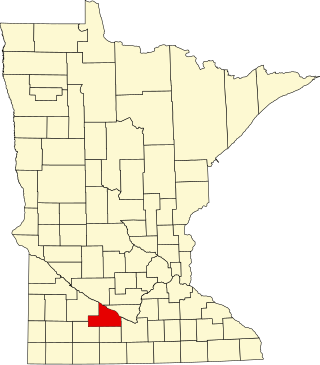
This is a list of the National Register of Historic Places listings in Blue Earth County, Minnesota. It is intended to be a complete list of the properties and districts on the National Register of Historic Places in Blue Earth County, Minnesota, United States. The locations of National Register properties and districts for which the latitude and longitude coordinates are included below, may be seen in an online map.
This is a list of the National Register of Historic Places listings in Brown County, Minnesota. It is intended to be a complete list of the properties and districts on the National Register of Historic Places in Brown County, Minnesota, United States. The locations of National Register properties and districts for which the latitude and longitude coordinates are included below, may be seen in an online map.
This is a list of the National Register of Historic Places listings in Morrison County, Minnesota. It is intended to be a complete list of the properties and districts on the National Register of Historic Places in Morrison County, Minnesota, United States. The locations of National Register properties and districts for which the latitude and longitude coordinates are included below, may be seen in an online map.
This is a list of the National Register of Historic Places listings in Otter Tail County, Minnesota. It is intended to be a complete list of the properties and districts on the National Register of Historic Places in Otter Tail County, Minnesota, United States. The locations of National Register properties and districts for which the latitude and longitude coordinates are included below, may be seen in an online map.
This is a list of the National Register of Historic Places listings in Pine County, Minnesota. It is intended to be a complete list of the properties and districts on the National Register of Historic Places in Pine County, Minnesota, United States. The locations of National Register properties and districts for which the latitude and longitude coordinates are included below, may be seen in an online map.
This is a list of the National Register of Historic Places listings in Lake County, Minnesota. It is intended to be a complete list of the properties and districts on the National Register of Historic Places in Lake County, Minnesota, United States. The locations of National Register properties and districts for which the latitude and longitude coordinates are included below, may be seen in an online map.
This is a list of the National Register of Historic Places listings in Rock County, Minnesota. It is intended to be a complete list of the properties and districts on the National Register of Historic Places in Rock County, Minnesota, United States. The locations of National Register properties and districts for which the latitude and longitude coordinates are included below, may be seen in an online map.
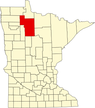
This is a list of the National Register of Historic Places listings in Cass County, Minnesota. It is intended to be a complete list of the properties and districts on the National Register of Historic Places in Cass County, Minnesota, United States. The locations of National Register properties and districts for which the latitude and longitude coordinates are included below, may be seen in an online map.
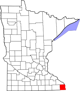
This is a list of the National Register of Historic Places listings in Cook County, Minnesota. It is intended to be a complete list of the properties and districts on the National Register of Historic Places in Cook County, Minnesota, United States. The locations of National Register properties and districts for which the latitude and longitude coordinates are included below, may be seen in an online map.
This is a list of the National Register of Historic Places listings in Houston County, Minnesota. It is intended to be a complete list of the properties and districts on the National Register of Historic Places in Houston County, Minnesota, United States. The locations of National Register properties and districts for which the latitude and longitude coordinates are included below, may be seen in an online map.
This is a list of the National Register of Historic Places listings in Koochiching County, Minnesota. It is intended to be a complete list of the properties and districts on the National Register of Historic Places in Koochiching County, Minnesota, United States. The locations of National Register properties and districts for which the latitude and longitude coordinates are included below, may be seen in an online map.
This is a list of the National Register of Historic Places listings in Aitkin County, Minnesota.
This is a list of the National Register of Historic Places listings in Becker County, Minnesota. It is intended to be a complete list of the properties and districts on the National Register of Historic Places in Becker County, Minnesota, United States. The locations of National Register properties and districts for which the latitude and longitude coordinates are included below may be seen in an online map.
This is a list of the National Register of Historic Places listings in Lyon County, Minnesota. It is intended to be a complete list of the properties and districts on the National Register of Historic Places in Lyon County, Minnesota, United States. The locations of National Register properties and districts for which the latitude and longitude coordinates are included below, may be seen in an online map.
This is a list of the National Register of Historic Places listings in Swift County, Minnesota. It is intended to be a complete list of the properties and districts on the National Register of Historic Places in Swift County, Minnesota, United States. The locations of National Register properties and districts for which the latitude and longitude coordinates are included below, may be seen in an online map.
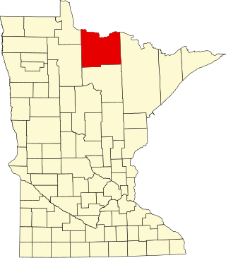
This is a list of the National Register of Historic Places listings in Beltrami County, Minnesota. This is intended to be a complete list of the properties and districts on the National Register of Historic Places in Beltrami County, Minnesota, United States. The locations of National Register properties and districts for which the latitude and longitude coordinates are included below, may be seen in an online map.
This is a list of the National Register of Historic Places listings in Dodge County, Minnesota. It is intended to be a complete list of the properties and districts on the National Register of Historic Places in Dodge County, Minnesota, United States. The locations of National Register properties and districts for which the latitude and longitude coordinates are included below, may be seen in an online map.
{{cite journal}}
: Cite journal requires |journal=
(help){{cite journal}}
: Cite journal requires |journal=
(help){{cite journal}}
: Cite journal requires |journal=
(help){{cite journal}}
: Cite journal requires |journal=
(help){{cite journal}}
: Cite journal requires |journal=
(help){{cite journal}}
: Cite journal requires |journal=
(help){{cite journal}}
: Cite journal requires |journal=
(help){{cite journal}}
: Cite journal requires |journal=
(help){{cite journal}}
: Cite journal requires |journal=
(help){{cite journal}}
: Cite journal requires |journal=
(help){{cite journal}}
: Cite journal requires |journal=
(help)