Navy Nagar | |
---|---|
Neighbourhood | |
Coordinates: 18°54′04″N72°48′36″E / 18.9012°N 72.8101°E | |
Country | India |
State | Maharashtra |
District | Mumbai City |
City | Mumbai |
Zone | 1 |
Ward | A |
Government | |
• Type | Municipal Corporation |
• Body | Brihanmumbai Municipal Corporation (MCGM) |
Elevation | 4 m (13 ft) |
Languages | |
• Official | Marathi |
Time zone | UTC+5:30 (IST) |
PIN | 400 005 |
Lok Sabha constituency | Mumbai South |
Vidhan Sabha constituency | Colaba |
Civic agency | BMC |
Navy Nagar is a cantonment area in Mumbai, India, and was established in 1796. [1] The area is owned and managed solely by the Indian Navy and entry to this area is highly restricted. Entry and exit points to the area are heavily manned by Naval Police.
Navy Nagar is located at the extreme south promontory of Mumbai city, and is linked to it through the Colaba Causeway. Entry into Navy Nagar is restricted as many important officials of the Indian Navy reside in the cantonment. It is Asia's largest naval armed forces personnel residential base. [2]
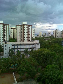
Navy Nagar houses the residences of Naval officers (also known as NOFRA) and sailors. Navy Nagar is divided into two different sections. Section one consists of "old navy nagar" and consists of smaller (generally five or lesser storied) buildings that were built up to the 1980s. "New navy nagar" consists of taller (14 storied) buildings, though a few older existing buildings are also included in it. The Tata Institute of Fundamental Research carries out research in higher sciences and the Indian Meteorological Department office (built in 1826) of Colaba are also located in Navy nagar.
Navy Nagar is maintained by the Indian Navy, law and order in the area is handled by the Naval Police and Military Police. The area is well maintained and has a large amount of greenery including an 18-hole golf course.
The region today called Navy Nagar originally consisted of an uninhabited island called "Old Woman's Island" (a distorsion of its older native name "Al Omani"), mostly covered with forests. [3] In 1743, the island of Colaba was leased to a British man called Richard Broughton at a sum of Rs. 200 per annum, a lease that was renewed in 1764. At that time, Colaba was well known for the variety of fish that were found in nearby waters, including bombil (the dried form of which is called "Bombay Duck"), rawas, halwa, turtles, crabs, prawns and lobsters. By 1796 Colaba became a cantonment for British troops. Gradually, troops began to build structures towards the southern end of the island, then called "Upper Colaba", and a meteorological observatory (today known as Colaba Observatory) was established in 1826. [4]
With the completion of the Colaba Causeway in 1838, these remaining two islands were joined to the rest of Mumbai. While Colaba became a centre of commerce with the opening of the Cotton Exchange at Cotton Green in 1844, the southern part of the island continued to remain mostly under the control of the defence.
During the subsequent construction of Colaba, a large network of bungalows called the "Sick Bungalows" (today INHS Aswini) were built. [5] The church today known as Afghan Church (after the First Afghan War of 1838) was consecrated in 1858 and work on the steeple was concluded in 1865. Horse-drawn tram-cars operated by Stearns and Kitteredge (whose offices are today's "Electric House") provided transport to this new developed area. Afghan Church was also built around this time, making it one of the earliest structures built in the area. The spire of the church was often used by sailors to get their bearing. [6]
Prong's Lighthouse, located at the southern tip of the island, was constructed in 1875, in the same year as Sassoon Docks were built by David Sassoon on reclaimed land to the north of Navy Nagar. [7] The development of a railway terminus (BB&CI Railways) in Colaba and land reclamation pushed existing indigenous kolis to the edges of the island, towards an area to the north of today's "New Navy Nagar". Meanwhile, structures and bungalows continued to be built sporadically in Navy Nagar to house members of the troops. In 1926, a motor bus route was introduced between Afghan church, located at the fringes of Navy Nagar and Crawford market. [8]
Navy Nagar truly started to be developed in the 1960s with the laying out of neat well planned roads, setting up of the Western naval command, construction of sailors quarters in the vicinity of a market for defence personnel (Sumitra market) and the building of accommodations for bachelors, a mess for officers (Command mess), a sports stadium and swimming pool (Kohli stadium), accommodations for the survivors of the naval ship INS Khukri (Khukri house) and the setting up of the TIFR. In the 1970s, A large circular canteen (INCS Canteen) was built for defence personnel along with residences for petty officers (buildings "A" to "K"), residences for officers (buildings "L" to "Z") and a school for their children (Kendriya Vidyalaya 1). Two cinemas were built specially for defence personnel - an open-air cinema for sailors (called "The Ground") and an enclosed cinema (called "Defence cinema"). In 1979, multi storied buildings were constructed to accommodate the growing numbers of officers, beginning with buildings called Swati, Meena and Bharani. All through, large open spaces with gardens were provided alongside these buildings. [9]
Six schools are located within the premises of the area:
Additionally, there is a school, Kendriya Vidyalaya No 3, located at R.C. Church (St. Joseph RC Church). [10]
The area is well connected by the public transport of B.E.S.T buses. Bus No 3 serves routes between Navy Nagar and JIJAMATA UDYAN. Bus No 11LTD serves routes between Navy Nagar and BANDRA COLONY BUS STATION. Bus No 125 serves routes between Navy Nagar and WORLI VILLAGE. Bus No 137 starts and ends at Navy Nagar. The nearest railway stations to the area are Churchgate Station and the Chhatrapati Shivaji Terminus Station.
Dadar ([d̪aːd̪əɾ]) is a densely populated residential and shopping neighbourhood in Mumbai. It is also a prominent railway and bus service hub with local and national connectivity. It is Mumbai’s first planned area and it a hub for the city's Marathi culture. It includes the Dadar West area.
Santacruz or Santa Cruz is a suburb of Mumbai. The Santacruz railway station on the Mumbai Suburban Railway, the domestic terminal (T1) of the Chhatrapati Shivaji Maharaj International Airport, and one campus of the University of Mumbai, are all located in Santacruz (East).
Colaba is a part of the city of Mumbai, India. It is one of the four peninsulas of Mumbai while the other three are Worli, Bandra and Malabar Hill. During Portuguese rule in the 16th century, the island was known as Kolbhat. After the British took over the island in the late 17th century, it was known as Kolio.
Cotton Green is a suburb of Mumbai, and a noted residential and commercial area east of Parel, in central Mumbai, 8 km north of Colaba. It is also the name of a railway station on the Mumbai suburban railway, which lies along the Harbour line, which is a part of the Central Railway.
Bhandup is a suburban locality in Mumbai, in the state of Maharashtra, India. The name Bhandup is derived from Bhandupeshwar, one of the names of the Hindu god Shiva. An old temple dedicated to Lord Shiva, the Bhandupeshwar Mahadev Mandir, is located in Bhandup (west) near Moti Bai Wadi IDUBS high school. Sonapur signal is north lead line on L.B.S. Marg and south is dockyard colony. Bhandup railway station is on the Central line of the Mumbai Suburban Railway network. A few fast trains stop at Bhandup station, mostly during the peak hours.
Wadala is a neighborhood in Mumbai. Wadala Road is a station on the Harbour Line of Mumbai's railway network.
Tata Institute of Fundamental Research (TIFR) is an Indian Research Institute under the Department of Atomic Energy of the Government of India. It is a public deemed university located at Navy Nagar, Colaba in Mumbai. It also has campus in Bangalore, International Centre for Theoretical Sciences (ICTS), and an affiliated campus in Serilingampally near Hyderabad. TIFR conducts research primarily in the natural sciences, the biological sciences and theoretical computer science.
Avadi is a municipal corporation in Tamil Nadu lying within the Chennai Metropolitan Area, located in the Thiruvallur district of Tamil Nadu. It is situated west of Chennai, about 22 kilometres (14 mi) from Chennai Central Railway Station. It is surrounded by major defence establishments and is home to various universities and engineering colleges. The city is served by Avadi Railway Station of the Chennai Suburban Railway. As of 2011, Avadi had a population of 345,996, which is 10th most populous place in Tamil Nadu. It is home to the Heavy Vehicles Factory (HVF), Ordnance Factory Board (ODF) which houses Engine Factory and Combat Vehicles Research and Development Establishment (CVRDE). The lake in Avadi was known as Paaleripattu, which is now found only in very old land documents.
Sainikpuri is a residential neighbourhood in the northeastern part of Hyderabad City. It falls under Kapra mandal of Medchal-Malkajgiri District, and is currently administered under GHMC East Zone. It started as a co-operative housing society venture for retired army personnel, but now has houses which belong to other defence services as well as civilians. Late Brig M. K Rao, Late Brig S.N.Docca and Late Lt. Col. Tiwari Singh were the first few to have got plots in the society and had a vision to develop the colony into an elite area. The housing plots originally allotted to the members of the Sainikpuri co-operative society were of the size of 700–1,000 square yards each. Owing to this reason, most residences have large lawns and gardens. Roads are well laid and numbered. Avenues are lined with a variety of flowering and fruiting trees, and are ideal for morning and evening walks. The sprawling cantonment area, as well as The College of Defence Management (CDM) which is a premier establishment of the Indian armed forces, are in the vicinity of Sainikpuri. The old buildings are now slowly giving way to multi-storied apartments, and it is becoming a costlier affair to acquire living space in this area.
Ramakrishna Puram popularly known as R.K. Puram, is a residential colony in Delhi. Named after the saint Sri Ramakrishna, it houses many high-profile corporate houses.
The Church of St John the Evangelist, better known as the Afghan Church, is a church of Anglican heritage, that belongs to the Mumbai diocese of the Church of North India. Located in Mumbai, Maharashtra, India, it was built by the British between 1847 and 1858 to commemorate the dead of the First Afghan War and the disastrous 1842 retreat from Kabul. Memorials at the rear of the nave also record casualties from the Second Anglo-Afghan War. The foundation stone was laid in 1847; it was consecrated in 1858, and work on the steeple finished in 1865.
Dehu Road Cantt, is a military cantonment in the city of Pune, India which was established in October 1958. The Dehu Ordnance Depot and Dehu Ammunition Depot was setup in the 1940s.
Khadki is a cantonment in the city of Pune, India. It has now flourished as a quasi-metropolis & centered in the northern region of the city.
Jalahalli is a suburb in northern part of Bengaluru is one of the greenest areas of Bengaluru. It is mainly divided into Jalahalli East and Jalahalli West. Gangamma Circle is the junction between the roads connecting Jalahalli East, Jalahalli West, Jalahalli Village, and Jalahalli Cross. The National Academy of Customs and Narcotics in Bengaluru is located here.
Colaba Causeway, officially known as Shahid Bhagat Singh Road, is a commercial street, and a major causeway or land link between Colaba and the Old Woman's Island in the city of Mumbai, India.
Four Bungalows is a neighbourhood in Mumbai. It is located about three kilometres from Andheri station and is in the vicinity of Lokhandwala Complex and Seven Bungalows.
Captain Mahendra Nath Mulla, MVC was an officer of the Indian Navy. As the Commanding Officer of INS Khukri, he chose to go down with his ship when his ship was sunk during the Indo-Pakistani War of 1971.
INS Shikra, formerly known as INS Kunjali, is an Indian naval air station located at Colaba in Mumbai, Maharashtra. It is a heliport.
Marve Island was among a group of islands that lay to the west of Salsette island near Mumbai, India. Manori and Gorai on Dharavi Island lay to its north while Erangal and Madh on Madh Island lay to its south.