
Congleton is a market town and civil parish in the unitary authority of Cheshire East in Cheshire, England. It is on the River Dane, 21 miles (34 km) south of Manchester and 13 miles (21 km) north of Stoke on Trent. At the 2021 census, it had a population of 30,015.

Congleton was, from 1974 to 2009, a local government district with borough status in Cheshire, England. It included the towns of Congleton, Alsager, Middlewich and Sandbach. The headquarters of the borough council were located in Sandbach.

Waresley is a village and former civil parish, now in the parish of Waresley-cum-Tetworth, in Cambridgeshire, England. Waresley lies approximately 11 miles (18 km) south of Huntingdon and 5 miles (8 km) south-east of the town of St Neots. Waresley is situated within Huntingdonshire which is a non-metropolitan district of Cambridgeshire as well as being a historic county of England.
Catworth is a village and civil parish in Cambridgeshire, England. Catworth lies approximately 9 miles (14 km) west of Huntingdon. The civil parish covers an area of 3,094 acres. Catworth village has two parts, Catworth, at the top of the hill, and Little Catworth, at the bottom. Catworth is situated within Huntingdonshire which is a non-metropolitan district of Cambridgeshire as well as being a historic county of England.

Stibbington is a village in Cambridgeshire, England, located approximately 6 miles (10 km) west of Peterborough city centre in the civil parish of Sibson-cum-Stibbington. It is situated in the far north-west corner of Huntingdonshire, which is a non-metropolitan district of Cambridgeshire, as well as a historic county of England.

Alpraham is a village and former civil parish, now in the parish of Alpraham and Calveley, in the Cheshire East district, in the ceremonial county of Cheshire, England. It is on the A51 road between Nantwich and Chester, seven miles north-west of Nantwich. The population is around 400.

Antrobus is a civil parish and village in Cheshire, England, about 7 miles (11 km) south of Warrington. It lies within the unitary authority of Cheshire West and Chester, and had a population of 832, reducing to 791 at the 2011 Census, and to 767 in the 2021 Census. The parish is the most northeasterly point of Cheshire West and Chester, and as such borders both Warrington and Cheshire East. As well as Antrobus village centre itself, the parish includes other large hamlets at Frandley, about 1 mi (1.6 km) south-west from the main village, and Crowley, about 2 mi (3.2 km) to the north-east.
Barthomley is a village and ancient parish, and is now a civil parish in the unitary authority of Cheshire East and the ceremonial county of Cheshire, England. According to the 2001 and the 2011 census' the parish had a population of 202. The village is situated near junction 16 of the M6 motorway and by the border with Staffordshire. It is about three miles south-west of Alsager.
Blakenhall is a small village and former civil parish, now in the parish of Doddington and District, in the unitary authority area of Cheshire East and the ceremonial county of Cheshire, England, about 7 miles (11 km) south-east of Nantwich. It lies on the county boundary with Staffordshire. The parish has an area of 654 hectares and also includes the small settlements of The Den and Gonsley Green, with a total population of 125 in 2001. Nearby villages include Wybunbury in Cheshire and Betley and Wrinehill in Staffordshire. Blakenhall was first recorded in the Domesday survey as Blachenhale, and the parish had one of Cheshire's early ironworks in the 17th and 18th centuries. The area is rural and predominantly agricultural, with small areas of ancient woodland and the nature reserve of Blakenhall Moss, a rejuvenating lowland raised bog. The Crewe-to-Stafford railway line runs through the parish and it is on the proposed route of HS2.
Eccleston is a village and former civil parish, now in the parish of Eaton and Eccleston, in the borough of Cheshire West and Chester, in the ceremonial county of Cheshire, England. The village is approximately 2.7 miles (4.3 km) to the south of the city of Chester, near to the River Dee. The village is situated on the estate of the Duke of Westminster who maintains his ancestral home at nearby Eaton Hall.
Astbury was one of the eight ancient parishes of the Macclesfield Hundred of Cheshire, England. It included two chapelries and ten townships. The chapelry of Congleton was an ancient borough and became a municipal borough in 1835. Under the Poor Law Amendment Act 1886 the townships and chapelries became civil parishes in their own right. Nine of the townships became part of Congleton Rural District in 1894. whereas Eaton became part of Macclesfield Rural District. At the same time, the Chapelry of Buglawton was made an Urban Sanitary District before being abolished in 1936. On its abolition 2,865 acres (11.59 km2) were transferred to Congleton, 32 acres (130,000 m2) to Eaton and 14 acres (57,000 m2) to North Rode.

Norbury is a hamlet and former civil parish, now in the parish of Marbury and District, in the Cheshire East district, in the ceremonial county of Cheshire, England. It included the small settlements of Gauntons Bank, Hurst Green, Swanwick Green, Norbury Common and Holtridge, with a total population of 194 people in 2011. The hamlet of Norbury lies around 5 miles (8 km) north of Whitchurch, Shropshire. Nearby villages include No Man's Heath, Marbury and Wrenbury.

Church Lawton is a village and civil parish in the unitary authority area of Cheshire East and in the ceremonial county of Cheshire in England. Its eastern boundary forms part of the county boundary between Cheshire and Staffordshire. As the village is near Stoke-on-Trent, it has a Stoke postcode. In addition to ribbon development connecting Kidsgrove with Scholar Green, the parish also contains the hamlets of Lawton Gate, Lawton Heath and Lawton Heath End, and the Lawton Hall estate. According to the 2001 census, the population of the entire parish was 2,201.

Brereton is a civil parish in the Cheshire East district, in the ceremonial county of Cheshire, England. At the 2011 census, the population was 1,190. Brereton is mentioned in the Domesday book as the Manor of Bretune. The civil parish includes the hamlets of Brereton Green, Brereton Heath, Smethwick Green, Medhurst Green, Sandlow Green and Davenport.

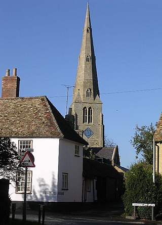
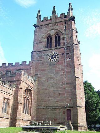
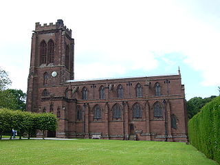
St Mary's Church is an Anglican parish church in the village of Newbold Astbury, Cheshire, England. It is recorded in the National Heritage List for England as a designated Grade I listed building, and its architecture has been praised by a number of writers.

Moreton cum Alcumlow is a small civil parish in the unitary authority of Cheshire East and the ceremonial county of Cheshire, England. In the census of 2001 it was recorded as having a population of 150. The civil parish holds a parish council meeting under a grouping scheme with the adjacent civil parish of Newbold Astbury, and so it is consequently called Newbold Astbury-cum-Moreton Parish Council. Within the civil parish is the small village of Ackers Crossing, and Alcumlow Hall and Great Moreton Hall.

Clutton is a village and civil parish in the unitary authority of Cheshire West and Chester and the ceremonial county of Cheshire, England. It lies nine miles from Wrexham and 11 miles from Chester. It had a population of 371 according to the 2011 census.
Sibson is a village in Cambridgeshire, England. Sibson lies approximately 6 miles (10 km) west of Peterborough city centre. Sibson is in the civil parish of Sibson-cum-Stibbington. Sibson is situated within Huntingdonshire which is a non-metropolitan district of Cambridgeshire as well as being a historic county of England. Sibson Aerodrome is 1 km south of the village.

Woolley is a hamlet and former civil parish, now in the parish of Barham and Woolley, in Cambridgeshire, England. Woolley lies approximately 5 miles (8 km) west of Huntingdon. The hamlet is in Huntingdonshire, which is a non-metropolitan district of Cambridgeshire as well as being a historic county of England. In 1931 the parish had a population of 29.
Newbold Astbury is a civil parish in Cheshire East, England. It contains 25 buildings that are recorded in the National Heritage List for England as designated listed buildings. Of these, one is listed at Grade I, the highest grade, three are listed at Grade II*, the middle grade, and the others are at Grade II. The major settlement in the parish is the village of Astbury; its listed buildings include the church and associated structures, houses and cottages, and a telephone kiosk. The Macclesfield Canal runs through the parish, and there are five listed buildings associated with this, three bridges, an aqueduct, and a milestone. Otherwise the parish is rural, and the listed buildings are farmhouses, farm buildings, and a boundary stone.

