
Austerson is a civil parish in the unitary authority of Cheshire East and the ceremonial county of Cheshire, England, lying immediately south of the town of Nantwich and north of the village of Audlem. Predominantly rural with scattered farms, the civil parish includes the small settlement of Old Hall Austerson at SJ656493, about two miles south of Nantwich centre. In 2001, the total population was a little under 150, increasing to 194 at the 2011 Census. Nearby villages include Broomhall Green, Hack Green, Hankelow, Sound Heath and Stapeley.

Basford is a hamlet and former civil parish, now in the parish of Weston and Crewe Green, in the unitary authority area of Cheshire East and the ceremonial county of Cheshire, England, lying immediately south of Crewe. Nearby villages include Shavington, Weston, Hough and Chorlton. The population was 256 in 2011. Basford was first recorded in the Domesday survey and had a moated manor. The modern parish is bisected by the A500 and the Crewe-to-Stafford railway line, and includes Basford Hall Sorting Sidings.

Buerton is a village at SJ685435 and civil parish in the unitary authority of Cheshire East and the ceremonial county of Cheshire, England, about 7 miles south of the town of Nantwich and 1½ miles east of the village of Audlem, on the border with Shropshire. The parish also includes the small settlements of Hankins Heys, Moblake, Pinder's End and Three Wells, as well as parts of Chapel End, College Fields, Kinsey Heath, Longhill, Raven's Bank, Sandyford and Woolfall. In 2001, the total population was a little under 500, which had increased marginally to 503 at the 2011 Census. Nearby villages include Adderley, Audlem, Bridgemere, Hankelow, Hatherton, Hunsterson and Woore.

Bulkeley is a village and former civil parish, now in the parish of Bulkeley and Ridley, in the unitary authority area of Cheshire East and the ceremonial county of Cheshire, England. The village is on the A534 road, 9 miles (14 km) west of Nantwich. In the 2011 census it had a population of 239.

Burland is a village and former civil parish, now in the parish of Burland and Acton, in the unitary authority area of Cheshire East and the ceremonial county of Cheshire, England, about 2+1⁄2 miles west of Nantwich. The civil parish also included the small settlements of Burland Lower Green, Burland Upper Green, Hollin Green and Stoneley Green, as well as parts of Gradeley Green and Swanley. The eastern part of the village of Ravensmoor also falls within the civil parish.
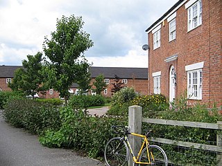
Woolstanwood is a village and civil parish in the unitary authority of Cheshire East and the ceremonial county of Cheshire, England, which lies immediately to the west of Crewe, 1½ miles from the centre. The parish also includes the settlements of Brassey Bank and Marshfield Bank. Nearby villages include Wistaston and Worleston.

Brindley is a village and civil parish in Cheshire, England. The village lies 3¾ miles to the west of Nantwich. The parish also includes the settlements of Brindley Lea, Ryders Bank and part of Radmore Green, with a total population of about 150. Nearby villages include Barbridge, Burland, Haughton and Faddiley.

Chorlton is a village and former civil parish, now in the parish of Hough and Chorlton, in the unitary authority area of Cheshire East and the ceremonial county of Cheshire, England. The village lies 4 miles (6.4 km) to the south east of Crewe. Nearby villages include Hough, Shavington, Weston and Wybunbury in Cheshire and Betley in Staffordshire. In 2011 the parish had a population of 897.

Crewe Green is a small village and former civil parish, now in the parish of Weston and Crewe Green, in the unitary authority area of Cheshire East and the ceremonial county of Cheshire, England. The village lies 1½ miles to the east of the centre of Crewe. The parish also includes a dispersed settlement of houses and farms called Slaughter Hill, the Jacobean mansion of Crewe Hall, and the industrial estates of Crewe Hall Enterprise Park and Crewe Hall Farm. Nearby villages include Haslington and Stowford.
Faddiley is a small village and civil parish in the unitary authority of Cheshire East and the ceremonial county of Cheshire, England. The village is located 4 miles to the west of Nantwich. The parish also includes the small settlements of Larden Green and Woodhey or Woodhey Green, with a total population of just over 150, measured at 163 during the 2011 Census. Nearby villages include Brindley, Burland, Chorley, Haughton and Ravensmoor.

Hough is a village and former civil parish, now in the parish of Hough and Chorlton, in the unitary authority area of Cheshire East and the ceremonial county of Cheshire, England. The village is 3 miles (4.8 km) south of Crewe and 4 miles (6.4 km) east of Nantwich. The parish also included part of the settlement of Goodalls Corner. The total population is a little over 800, measured at 808 in the 2011 Census. Nearby villages include Basford, Chorlton, Shavington, Weston and Wybunbury.

Hunsterson is a hamlet and former civil parish, now in the parish of Doddington and District, in the unitary authority area of Cheshire East and the ceremonial county of Cheshire, England. The hamlet is located 2¾ miles to the north east of Audlem and 6 miles to the south of Crewe. The parish also included the settlements of Brown Moss, Four Lane End, Foxes Bank and Whittaker's Green. In 2011 the parish had a population of 163. Nearby villages include Audlem, Buerton, Hatherton and Hankelow.

Peckforton is a scattered settlement and civil parish in the unitary authority of Cheshire East and the ceremonial county of Cheshire, England. The settlement is located 6.5 miles (10.5 km) to the north east of Malpas and 7.5 miles (12.1 km) to the west of Nantwich. The civil parish covers 1,754 acres (710 ha), with an estimated total population of 150 in 2006. The area is predominantly agricultural. Nearby villages include Bulkeley to the south, Beeston to the north, Higher Burwardsley to the west, Spurstow to the east and Bunbury to the north east.

Rope is a scattered settlement and civil parish in the unitary authority of Cheshire East and the ceremonial county of Cheshire, England. It lies immediately to the south of Crewe, with the centre of the parish being around 2¼ miles from the centre of Crewe. Nearby villages include Shavington, Willaston and Wistaston. The civil parish has a total population of just over 2150, reducing to 2,034 at the 2011 Census.

Shavington cum Gresty is a civil parish in the unitary authority of Cheshire East and the ceremonial county of Cheshire, England. It lies to the south of Crewe. It includes the large village of Shavington, which lies 2+1⁄2 miles south of Crewe, as well as the smaller settlements of Dodds Bank, Park Estate, Puseydale, Sugar Loaf and part of Goodall's Corner. Nearby villages include Basford, Hough, Willaston, Wistaston and Wybunbury. The total population of the civil parish is a little under 5,000.

Spurstow is a village and civil parish in the unitary authority of Cheshire East and the ceremonial county of Cheshire, England, which is located 6½ miles to the north west of Nantwich. The parish also includes the settlement of Spurstow Sketh and part of Radmore Green. The total population is a little over 400 people. Nearby villages include Bunbury, Haughton and Peckforton. The parish is mentioned in the Domesday Book of 1086 and contains a salt spring, which was formerly used as a spa.

Stapeley is a hamlet and former civil parish, now in the parish of Stapeley and District, in the unitary authority area of Cheshire East and the ceremonial county of Cheshire, England. The hamlet lies 2¼ miles to the south east of Nantwich. The parish also included the small settlements of Broad Lane and Butt Green, and parts of Artle Brook, Haymoor Green and Howbeck Bank, as well as a recent residential development north of the A5301 adjacent to Nantwich. In 2008, the total population was estimated to be a little under 3000, increasing to 3,336 at the 2011 Census. Nearby villages include Shavington, Willaston and Wybunbury.

Stoke is a former civil parish, now in the parish of Stoke and Hurleston, in the unitary authority area of Cheshire East and the ceremonial county of Cheshire, England. The parish was predominantly rural with a total population of 201 in 2001, measured with the inclusion of Hurleston at 324 in the 2011 Census. The largest settlement was Barbridge, which lies 3½ miles to the north west of Nantwich. The parish also included the small settlements of Stoke Bank and Verona. Nearby villages include Aston juxta Mondrum, Burland, Calveley, Haughton, Rease Heath and Wardle.

Walgherton is a village and civil parish in the unitary authority of Cheshire East and the ceremonial county of Cheshire, England. The village lies at SJ697489 by the junction of the A51 and B5071 roads, 3½ miles to the south east of Nantwich and 4½ miles to the south of Crewe. The civil parish also includes the small settlement of Hussey's Nook. The total population is just under 130 people. Sand has been extracted at Hough Mill Quarry. The remainder of the parish is predominantly agricultural. Nearby villages include Hatherton, Stapeley and Wybunbury.
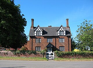
Weston is a former civil parish in Cheshire East, England. It contained 17 buildings that are recorded in the National Heritage List for England as designated listed buildings. Of these, one is listed at Grade II*, the middle of the three grades, and the others are at Grade II. The parish contained the villages of Weston and Englesea-Brook, and the southern part of the Crewe Hall estate. The listed buildings include houses, cottages and a lodge in the Crewe estate.. Elsewhere there are houses and cottages, a public house, a church, and a signpost. In Englesea-Brook the former Primitive Methodist church is now a museum, and its founder has a memorial in the churchyard opposite.


