Norbury, Cheshire

Last updated

Norbury
Terraced cottages, Norbury - geograph.org.uk - 380607.jpg
Terraced cottages in Norbury hamlet
Cheshire UK location map.svg
Red pog.svg
Norbury
Location within Cheshire
Population194 (2011)
OS grid reference SJ563468
Civil parish
Unitary authority
Ceremonial county
Region
Country England
Sovereign state United Kingdom
Post town WHITCHURCH
Postcode district SY13
Dialling code 01948
Police Cheshire
Fire Cheshire
Ambulance North West
UK Parliament
List of places
UK
England
Cheshire
53°01′23″N2°39′07″W / 53.023°N 2.652°W / 53.023; -2.652 ,

Norbury is a hamlet and former civil parish, now in the parish of Marbury and District, [1] in the Cheshire East district, in the ceremonial county of Cheshire, England. It included the small settlements of Gauntons Bank, Hurst Green, Swanwick Green, Norbury Common and Holtridge, [2] with a total population of 194 people in 2011. The hamlet of Norbury lies around 5 miles (8 km) north of Whitchurch, Shropshire. Nearby villages include No Man's Heath, Marbury and Wrenbury. [3] [4]

Contents

History

Former chapel on Norbury Town Lane Former chapel, Norbury - geograph.org.uk - 380634.jpg
Former chapel on Norbury Town Lane

Norberie was a small manor at the time of the Domesday survey in 1086. It was then held by William Malbank, Baron of Wich Malbank (Nantwich), and had been held by Earl Harold before the Norman Conquest. The record is combined with the nearby manors of Wirswall and Marbury. [5] [6] [7] The Anglo-Saxon manor is believed to have been a fortified farmstead. [8]

There were three Nonconformist chapels in the 19th century, all now defunct. [2] A Wesleyan Methodist chapel was constructed in 1834 on Norbury Town Lane in Norbury hamlet, and appears in John Marius Wilson's gazetteer entry of 1870–72. [2] [9] [10] Another Wesleyan Methodist chapel, also on Norbury Town Lane, dates from 1899 and closed in 1975. [11] A Congregationalist chapel was built in 1868 on Common Lane in Norbury Common. [2] [12]

Governance

Norbury is administered by the Marbury & District Parish Council, jointly with the adjacent civil parishes of Marbury cum Quoisley and Wirswall. [13] From 1974 the civil parish was served by Crewe and Nantwich Borough Council, which was succeeded on 1 April 2009 by the new unitary authority of Cheshire East. [14] Norbury falls in the parliamentary constituency of Eddisbury, [4] which has been represented by Edward Timpson since 2019, after being represented by Antoinette Sandbach (2015–19). [15]

Norbury was formerly a township in the parish of Marbury, [16] from 1866 Norbury was a civil parish in its own right, [17] on 1 April 2023 the parish was abolished to form "Marbury and District". [18]

Geography and transport

Llangollen Canal at Marbury Lock Marbury Lock - geograph.org.uk - 213694.jpg
Llangollen Canal at Marbury Lock

The civil parish has an area of 628 hectares (1,550 acres). [4] The terrain is undulating with low hills. The hamlet of Norbury stands on a low hill, and the high point of the parish is at an elevation of 112 metres (367 ft) immediately to its west, with a trig point and a covered reservoir. The Llangollen Canal runs along or just inside the southern boundary, before cutting into the south-east corner of the parish. At an elevation of 72–73 metres (236–240 ft), it forms the parish's low point. Steer Brook flows out of Bar Mere in Bickley to run along part of Norbury's western boundary; it then runs immediately south of the canal, turning southwards near the eastern boundary to join Marbury Brook. There are also numerous unnamed drains as well as occasional small ponds and meres within the area (although Norbury Meres lie in the adjacent parish of Cholmondeley). There are several small areas of woodland, including Canal Covert around the canal and Steer Brook, Handley Park Covert, and Norbury Common in the north-west corner of the parish, near Common Farm. [3] [4]

The A49 runs north–south just to the west of the parish, connecting via Marbury Road and Snab Lane with a network of lanes within Norbury parish. Two lanes lead towards Wrenbury: Frith Lane runs east to Cholmondeley Lane just outside Wrenbury village, and Holtridge Lane runs north to connect with the same lane further west. Another two lanes go south to Marbury: Marbury Road and School Lane, via two road bridges over the canal: Steer Bridge (carrying Marbury Road) and Church Bridge (School Lane). A lock, Marbury Lock, is located at Church Bridge. [3] [4]

Stokes Cottage, Swanwick Green Stokes Cottage, Swanwick Green.jpg
Stokes Cottage, Swanwick Green

Demography

The population has declined since the 19th century; historical population figures are 330 (1801), 403 (1851), 330 (1881), 289 (1901) and 241 (1951). [2] [19] According to the 2001 census, the civil parish had a population of 190, [2] remaining steady at 194 in 87 households at the 2011 census. [20] [21]

Landmarks

Brook Farmhouse, Gauntons Bank Brook Farm, Gauntons Bank - geograph.org.uk - 189363.jpg
Brook Farmhouse, Gauntons Bank

Several buildings in the civil parish are listed at grade II, the lowest of the three grades. [22] The oldest listed building may be Stokes Cottage in Swanwick Green, a timber-framed longhouse with brick infill and a thatched roof; it dates from the 16th or early 17th century. [23] Another candidate is Brook Farmhouse in Gauntons Bank, part of which originally dates from the late 16th century, and was subsequently extended several times. The original building is timber framed with brick infill and a tiled roof. [24]

The Holtridge in Holtridge is a T-shaped, red-brick farmhouse dating originally from the early 17th century; it has a 20th-century oriel window. [25] Olive Cottage in Norbury Common is a timber-framed building with brick infill and a thatched roof; it dates originally from the mid-17th century. [26] Church Bridge on the Llangollen Canal dates from the late 18th or early 19th century; its single span is constructed of red sandstone. [27]

Education

There are no educational facilities in Norbury. The civil parish falls within the catchment areas of Brine Leas School in Nantwich, and Wrenbury Primary School. [4]

See also

Related Research Articles

<span class="mw-page-title-main">Acton, Cheshire</span> Human settlement in England

Acton is a small village and former civil parish, now in the parish of Burland and Acton, lying immediately west of the town of Nantwich, in the unitary authority area of Cheshire East and the ceremonial county of Cheshire, England. The civil parish covered 762 acres (3.08 km2) and also included the small settlement of Dorfold and part of Burford, with an estimated population of 340 in 2006. It is administered jointly with the adjacent civil parishes of Henhull and Edleston. Historically, Acton refers to a township and also to an ancient parish in the Nantwich Hundred covering a wide area to the west of Nantwich. The area is agricultural, with dairy farming the main industry. Around a third of the area falls within the Dorfold Estate. Historically, agriculture was the major employer, but it has now been overtaken by the service industries, with many residents commuting significant distances outside the parish to work.

<span class="mw-page-title-main">Broomhall, Cheshire</span> Human settlement in England

Broomhall is a civil parish in the unitary authority of Cheshire East and the ceremonial county of Cheshire, England. The main line of the Shropshire Union Canal runs through the parish and the River Weaver forms part of its boundary. The main settlement is the hamlet of Broomhall Green, which lies on the A530 about 3.5 miles (5.6 km) south-west of Nantwich. The civil parish has an area of 539 hectares, and also includes part of the small settlement of Sandford, with a total population of around 200 in 2011. Nearby villages include Aston, Sound, Wrenbury and Audlem. Broomhall appears in the Domesday survey and the name was also historically spelled Bromhall.

<span class="mw-page-title-main">Buerton, Cheshire East</span> Human settlement in England

Buerton is a village at SJ685435 and civil parish in the unitary authority of Cheshire East and the ceremonial county of Cheshire, England, about 7 miles south of the town of Nantwich and 1½ miles east of the village of Audlem, on the border with Shropshire. The parish also includes the small settlements of Hankins Heys, Moblake, Pinder's End and Three Wells, as well as parts of Chapel End, College Fields, Kinsey Heath, Longhill, Raven's Bank, Sandyford and Woolfall. In 2001, the total population was a little under 500, which had increased marginally to 503 at the 2011 Census. Nearby villages include Adderley, Audlem, Bridgemere, Hankelow, Hatherton, Hunsterson and Woore.

<span class="mw-page-title-main">Bulkeley</span> Human settlement in England

Bulkeley is a village and former civil parish, now in the parish of Bulkeley and Ridley, in the unitary authority area of Cheshire East and the ceremonial county of Cheshire, England. The village is on the A534 road, 9 miles (14 km) west of Nantwich. In the 2011 census it had a population of 239.

<span class="mw-page-title-main">Burland</span> Human settlement in England

Burland is a village and former civil parish, now in the parish of Burland and Acton, in the unitary authority area of Cheshire East and the ceremonial county of Cheshire, England, about 2+12 miles west of Nantwich. The civil parish also included the small settlements of Burland Lower Green, Burland Upper Green, Hollin Green and Stoneley Green, as well as parts of Gradeley Green and Swanley. The eastern part of the village of Ravensmoor also falls within the civil parish.

<span class="mw-page-title-main">Marbury, Cheshire</span> Human settlement in England

Marbury is a small village located at SJ560457 in the civil parish of Marbury and District, formerly Marbury cum Quoisley, within the unitary authority of Cheshire East and the ceremonial county of Cheshire, England. It is administered jointly with the adjacent civil parishes of Norbury and Wirswall. The village lies around 3 miles (5 km) north east of Whitchurch in Shropshire and 7 miles (11 km) south west of Nantwich in Cheshire. Nearby villages include Malpas, No Man's Heath, Norbury, Wirswall and Wrenbury. The civil parish bordered Shropshire and covers 2,168 acres (877 ha); it also contains the small settlements of Hollins Lane, Marley Green and Quoisley, as well as parts of Hollyhurst and Willeymoor. The total population was just under 250 in 2001, and – combined with Wirswall – 352 in 2011.

<span class="mw-page-title-main">Wrenbury-cum-Frith</span> Human settlement in England

Wrenbury-cum-Frith is a village and civil parish in the unitary authority of Cheshire East, and the ceremonial county of Cheshire, England. It lies on the River Weaver, around 8.5 miles south-west of Crewe.

<span class="mw-page-title-main">Wirswall</span> Human settlement in England

Wirswall is a village and former civil parish, now in the parish of Marbury and District, in the unitary authority area of Cheshire East and the ceremonial county of Cheshire, England, located at SJ544441 near the Shropshire border, around 1½ miles north of Whitchurch. The historical township had an area of 973 acres (3.94 km2). The civil parish also included the settlements of Bradeley Green, Wicksted and part of Willey Moor.

<span class="mw-page-title-main">Cholmondeston</span> Village in Cheshire, England

Cholmondeston is a village and civil parish in the unitary authority of Cheshire East and the ceremonial county of Cheshire, England. The village lies 5 miles (8 km) to the northwest of Nantwich. Nearby villages include Aston juxta Mondrum, Barbridge, Calveley and Wettenhall. The Middlewich Branch of the Shropshire Union Canal and the Crewe–Chester railway line run through the civil parish. The area is predominantly rural, with a total population of around 150 in 2001, increasing to 175 at the 2011 Census.

<span class="mw-page-title-main">Chorlton, Cheshire East</span> Human settlement in England

Chorlton is a village and former civil parish, now in the parish of Hough and Chorlton, in the unitary authority area of Cheshire East and the ceremonial county of Cheshire, England. The village lies 4 miles (6.4 km) to the south east of Crewe. Nearby villages include Hough, Shavington, Weston and Wybunbury in Cheshire and Betley in Staffordshire. In 2011 the parish had a population of 897.

<span class="mw-page-title-main">Hatherton, Cheshire</span> Hamlet and civil parish, Cheshire, England, UK

Hatherton is a hamlet and civil parish in the unitary authority of Cheshire East and the ceremonial county of Cheshire, England. The hamlet is on the B5071 at SJ687474, 2+34 miles (4.4 km) to the north east of Audlem and 3+34 miles (6.0 km) to the south east of Nantwich. The civil parish has an area of 673 hectares and also includes the small settlements of Birchall Moss, Broomlands and part of Artlebrook, with a total population of 360 in 2011. Nearby villages include Hankelow, Stapeley, Walgherton, Wybunbury, Blakenhall and Buerton. The A529 runs through the parish and the River Weaver forms the western boundary.

<span class="mw-page-title-main">Hunsterson</span> Human settlement in England

Hunsterson is a hamlet and former civil parish, now in the parish of Doddington and District, in the unitary authority area of Cheshire East and the ceremonial county of Cheshire, England. The hamlet is located 2¾ miles to the north east of Audlem and 6 miles to the south of Crewe. The parish also included the settlements of Brown Moss, Four Lane End, Foxes Bank and Whittaker's Green. In 2011 the parish had a population of 163. Nearby villages include Audlem, Buerton, Hatherton and Hankelow.

<span class="mw-page-title-main">Minshull Vernon</span> Human settlement in England

Minshull Vernon is a hamlet and civil parish in the unitary authority of Cheshire East and the ceremonial county of Cheshire, England. The hamlet lies 3 miles (5 km) to the north west of Crewe, south east of Winsford and south west of Middlewich. The parish also includes the small settlements of Bradfield Green, Eardswick, Hoolgrave, Minshull Hill, Walley's Green and Weaver Bank. The total population of the civil parish is somewhat over 200, measured at 391 in the Census 2011. Nearby villages include Church Minshull, Warmingham and Wimboldsley.

<span class="mw-page-title-main">Sound, Cheshire</span> Human settlement in England

Sound is a hamlet and civil parish in the unitary authority of Cheshire East and the ceremonial county of Cheshire, England. The hamlet is located 3+14 miles (5.2 km) to the south west of Nantwich. The civil parish covers 1,089 acres (441 ha) and also includes the small settlements of Newtown and Sound Heath, with a total population at the 2011 Census of 239. Nearby villages include Aston, Ravensmoor and Wrenbury.

<span class="mw-page-title-main">Walgherton</span> Human settlement in England

Walgherton is a village and civil parish in the unitary authority of Cheshire East and the ceremonial county of Cheshire, England. The village lies at SJ697489 by the junction of the A51 and B5071 roads, 3½ miles to the south east of Nantwich and 4½ miles to the south of Crewe. The civil parish also includes the small settlement of Hussey's Nook. The total population is just under 130 people. Sand has been extracted at Hough Mill Quarry. The remainder of the parish is predominantly agricultural. Nearby villages include Hatherton, Stapeley and Wybunbury.

<span class="mw-page-title-main">Edleston</span> Human settlement in England

Edleston is a former civil parish, now in the parish of Burland and Acton, in the unitary authority area of Cheshire East and the ceremonial county of Cheshire, England, which lies immediately to the south west of Nantwich. For administrative purposes, it was combined with adjacent civil parishes of Acton and Henhull to form a total area of 765 hectares. The parish was predominantly rural with scattered farms and houses, with the exception of a new housing estate at the eastern end of the parish east of the canal. Nearby villages include Acton and Ravensmoor.

<span class="mw-page-title-main">Poole, Cheshire</span> Village in Cheshire, England

Poole is a civil parish in the unitary authority of Cheshire East and the ceremonial county of Cheshire, England, which lies to the north west of Nantwich and to the west of Crewe. The Shropshire Union Canal runs through the parish. Nearby villages include Acton, Aston juxta Mondrum, Barbridge, Stoke Bank, Rease Heath and Worleston.

<span class="mw-page-title-main">Swanley, Cheshire</span>

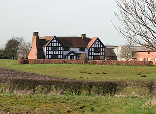
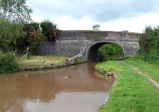
Swanley is a hamlet at SJ618523 in the unitary authority of Cheshire East and the ceremonial county of Cheshire, England. It mainly falls within the civil parish of Burland, with a part in Baddiley. Swanley lies around 2+12 miles (4.0 km) to the west of Nantwich and immediately north of the hamlet of Stoneley Green. Nearby villages include Burland, Acton and Ravensmoor. A dry moated site is located near the 16th-century Swanley Hall, and there are two 17th-century buildings. The Llangollen Canal runs through the hamlet, with two locks, two bridges and a marina.

<span class="mw-page-title-main">Hankelow</span> Human settlement in England

Hankelow is a village and civil parish in the unitary authority of Cheshire East and the ceremonial county of Cheshire, England. The village lies on the A529, around 1.25 miles (2.0 km) north east of Audlem and 4.5 miles (7.2 km) south of Nantwich. The civil parish has an area 369 hectares and also includes the small settlement of The Dell and part of Corbrook, with a total population of just over 260 in 2011. Nearby villages include Aston, Broomhall Green, Sound, Hatherton and Buerton in Cheshire and Woore in Shropshire.

<span class="mw-page-title-main">Listed buildings in Wrenbury cum Frith</span>

Fourteen buildings and other structures in the English civil parish of Wrenbury cum Frith have been officially designated as listed buildings for their "special architectural and historic interest". Three of the listed buildings are classified as being in grade II* and the remainder in grade II; the parish has no grade-I-listed buildings.

References

  1. "Marbury and District". Mapit. Retrieved 6 July 2023.
  2. 1 2 3 4 5 6 Norbury (near Malpas), UK & Ireland Genealogy, retrieved 4 March 2020
  3. 1 2 3 Crewe & Nantwich: Whitchurch & Tattenhall (OS Explorer series 257), Ordnance Survey, 2000, ISBN   0-319-21893-7
  4. 1 2 3 4 5 6 Search at Cheshire East Council Public Map Viewer (accessed 3 March 2020)
  5. Husain, frontispiece
  6. "Cheshire L–Z", The Domesday Book Online, retrieved 3 March 2020
  7. Anna Powell-Smith; J. J. N. Palmer; et al., "Land of Gilbert the hunter", Open Domesday, retrieved 3 March 2020
  8. Bu'Lock pp. 61–62
  9. "Norbury, Cheshire", A Vision of Britain through Time, University of Portsmouth , retrieved 3 March 2020
  10. Norbury Town Lane, Norbury, Methodist (Wesleyan), UK & Ireland Genealogy, retrieved 4 March 2020
  11. Norbury Town Lane, Norbury, Methodist (Wesleyan), UK & Ireland Genealogy, retrieved 4 March 2020
  12. Common Lane, Norbury Common, Norbury, Congregationalist, UK & Ireland Genealogy, retrieved 4 March 2020
  13. Local History Group & Latham (ed.), p. 138
  14. The Cheshire (Structural Changes) Order 2008, The National Archives, 4 March 2008, retrieved 3 March 2020
  15. Eddisbury Parliamentary constituency, BBC, retrieved 3 March 2020
  16. "History of Norbury, in Crewe and Nantwich and Cheshire". A Vision of Britain through Time . Retrieved 6 July 2023.
  17. "Relationships and changes Norbury Tn/CP through time". A Vision of Britain through Time. Retrieved 6 July 2023.
  18. "Cheshire East Registration District". UKBMD. Retrieved 9 October 2023.
  19. "Norbury Tn/CP: Population Statistics: Total Population: Table view", A Vision of Britain through Time, University of Portsmouth , retrieved 3 March 2020
  20. "Civil Parish population 2011", Neighbourhood Statistics, Office for National Statistics, retrieved 16 March 2016
  21. UK Census (2011), "Local Area Report – Norbury Parish (E04010983)", Nomis, Office for National Statistics , retrieved 4 March 2020
  22. Listed Buildings, Historic England, retrieved 4 March 2020
  23. Historic England, "Stokes Cottage (1357117)", National Heritage List for England , retrieved 3 March 2020
  24. Historic England, "Brook Farmhouse, Norbury (1357116)", National Heritage List for England, retrieved 3 March 2020
  25. Historic England, "The Holtridge, Norbury (1066618)", National Heritage List for England, retrieved 4 March 2020
  26. Historic England, "Olive Cottage, Norbury (1066617)", National Heritage List for England, retrieved 4 March 2020
  27. Historic England, "Church Bridge, Norbury (1137020)", National Heritage List for England, retrieved 3 March 2020
Sources

Commons-logo.svg Media related to Norbury, Cheshire at Wikimedia Commons