Rostherne

Last updated

Rostherne
Rostherne - Saint Mary's Church.jpg
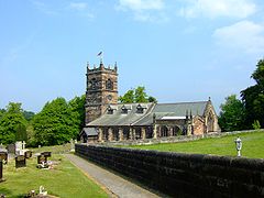
Saint Mary's Church, Rostherne
Cheshire UK location map.svg
Red pog.svg
Rostherne
Location within Cheshire
Population160 (2001 census)
OS grid reference SJ744837
Civil parish
Unitary authority
Ceremonial county
Region
Country England
Sovereign state United Kingdom
Post town KNUTSFORD
Postcode district WA16
Dialling code 01565
Police Cheshire
Fire Cheshire
Ambulance North West
UK Parliament
List of places
UK
England
Cheshire
53°21′00″N2°22′59″W / 53.350°N 2.383°W / 53.350; -2.383

Rostherne is a village and former civil parish, now in the parish of Millington and Rostherne, [1] in the unitary authority area of Cheshire East and the ceremonial county of Cheshire, England (grid reference SJ743835 ). In 2001 the parish had a population of 160.

Contents

To the north of the village is Rostherne Mere and to the south is Tatton Park. The A556 road passes to its west.

History

In the 11th century Rostherene was called Rodestorne, said to mean the Lake of the Holy Cross, from the Anglo-Saxon Rodes, meaning cross and the northern word torne or tarne meaning lake. At the time of the Domesday Book the parish belonged to Gilbert de Venables, Baron of Kinderton, who displaced Ulviet the Saxon as owner of the lands, although there was then only one rateable field in the parish, one team and two acres of wood, the whole only being worth four shillings a year. By 1286 almost all of Rostherne had become part of the Tatton estate, having been sold to Massey of Tatton, except for a portion retained by the Leghs. [2]

On 1 April 2023 the parish was abolished to form "Millington and Rostherne". [3]

Buildings

St Mary's Church, Rostherne, is a Grade I listed building, [4] whose rectory was for many centuries in the possession of the Leighs of West Hall, High Legh.

Notable people

See also

Related Research Articles

<span class="mw-page-title-main">Disley</span> Village in Cheshire, England

Disley is a village and civil parish in Cheshire, England. It is located on the edge of the Peak District in the Goyt valley, south of Stockport and close to the county boundary with Derbyshire at New Mills. The population at the 2011 Census was 4,294. To the north, the River Goyt and the Peak Forest Canal, which opened in 1800, pass along the edge of the village. Today, it is a dormitory village retaining a semi-rural character.

<span class="mw-page-title-main">High Legh</span> Human settlement in England

High Legh is a village, civil and ecclesiastical parish in the unitary authority of Cheshire East and the ceremonial county of Cheshire, England. It is Six miles (10 km) north west of Knutsford, seven miles (11 km) east of Warrington and twelve miles (19 km) south west of Manchester City Centre. The population of the entire civil parish was estimated at 1,705 in 2019.

<span class="mw-page-title-main">Northenden</span> Suburb in Manchester, Greater Manchester, England

Northenden is a suburb of Manchester, Greater Manchester, England, with a population of 14,771 at the 2011 census. It lies on the south side of the River Mersey, 4.2 miles (6.8 km) west of Stockport and 5.2 miles (8.4 km) south of Manchester city centre, bounded by Didsbury to the north, Gatley to the east, Sale to the west and Wythenshawe to the south.

<span class="mw-page-title-main">St Peter's Church, Prestbury</span> Church in Cheshire, England

St Peter's Church is the parish church of Prestbury, Cheshire, England. It is probably the fourth church on the site. The third, the Norman Chapel, stands in the churchyard. The church is recorded in the National Heritage List for England as a designated Grade I listed building. The Norman Chapel, the lychgate and west wall, the Hearse House, and the sundial in the churchyard are listed at Grade II. It is a Church of England parish church in the diocese of Chester, the archdeaconry of Macclesfield, and the deanery of Macclesfield.

<span class="mw-page-title-main">Cheshire East</span> Borough in England

Cheshire East is a unitary authority area with borough status in Cheshire, England. The local authority is Cheshire East Council. Towns within the area include Crewe, Macclesfield, Congleton, Sandbach, Wilmslow, Handforth, Knutsford, Poynton, Bollington, Alsager and Nantwich. The council is based in the town of Sandbach.

<span class="mw-page-title-main">St Mary's Church, Astbury</span> Church in Cheshire, England

St Mary's Church is an Anglican parish church in the village of Newbold Astbury, Cheshire, England. It is recorded in the National Heritage List for England as a designated Grade I listed building, and its architecture has been praised by a number of writers.

<span class="mw-page-title-main">St Wilfrid's Church, Mobberley</span> Church in Cheshire, England

St Wilfrid's Church stands to the north of the village of Mobberley, Cheshire, England. The church is recorded in the National Heritage List for England as a designated Grade I listed building. It is an active Anglican parish church in the diocese of Chester, the archdeaconry of Macclesfield and the deanery of Knutsford. Alec Clifton-Taylor includes it in his list of 'best' English parish churches.

<span class="mw-page-title-main">St Mary's Church, Rostherne</span> Church in Cheshire, England

St Mary's Church lies between the village of Rostherne and Rostherne Mere in Cheshire, England. The church is recorded in the National Heritage List for England as a designated Grade I listed building. It is an active Anglican parish church in the diocese of Chester, the archdeaconry of Macclesfield and the deanery of Knutsford. Its benefice is united with that of Holy Trinity, Bollington.

<span class="mw-page-title-main">St Oswald's Church, Winwick</span> Church in Cheshire, England

St Oswald's Church, is in the village of Winwick, Cheshire, England. The church is recorded in the National Heritage List for England as a designated Grade I listed building. It is an active Anglican parish church in the diocese of Liverpool, the archdeaconry of Warrington and the deanery of Winwick.

<span class="mw-page-title-main">Swettenham</span> Village in Cheshire, England

Swettenham is a village and civil parish in the unitary authority of Cheshire East and the ceremonial county of Cheshire, England. According to the 2001 Official UK Census, the population of the entire civil parish was 248, increasing to 291 at the 2011 Census. The civil parish includes the hamlet of Kermincham.

<span class="mw-page-title-main">St Mary's Church, Disley</span> Church in Cheshire, England

St Mary's Church is an Anglican parish church in the diocese of Chester, the archdeaconry of Macclesfield and the deanery of Chadkirk. It is on a hill overlooking the village of Disley, Cheshire, England. It is recorded in the National Heritage List for England as a designated Grade II* listed building. Its benefice is combined with that of St John, Furness Vale.

<span class="mw-page-title-main">Baguley Hall</span> Building in Greater Manchester, UK

Baguley Hall is a 14th-century timber-framed building in Baguley, Greater Manchester, North West England.

<span class="mw-page-title-main">St Mary's Chapel, High Legh</span> Church in Cheshire, England

St Mary's Chapel is a former Anglican parish church in the village of High Legh, Cheshire, England. It is recorded in the National Heritage List for England as a designated Grade II* listed building.

<span class="mw-page-title-main">Millington, Cheshire</span> Human settlement in England

Millington is a former civil parish, now in the parish of Millington and Rostherne, in the Cheshire East district, in the ceremonial county of Cheshire, England. The parish was 8 miles (13 km) from Warrington and 3 miles (5 km) from Altrincham. Its name is a "relic of Saxon clanship – the ton or town of the Millings". The parish is primarily agricultural, with a number of farms including Moss House Farm, Newhall Farm, Mereside Farm, Boothbank Farm and Stonedelph Farm. Millington has been recently described on Britain Streets as a "hamlet or isolated settlement in the inhabited countryside". Millington is situated within the market town Macclesfield. The M56 motorway was close to the parish, which allows travel into areas of Warrington and Manchester, 13 miles (21 km) and 14 miles (23 km) away respectively. In 2011 the parish had a population of 234.

<span class="mw-page-title-main">Tatton, Cheshire</span> Human settlement in England

Tatton is a former civil parish, now in the parish of Millington and Rostherne, in the Cheshire East district and ceremonial county of Cheshire in England. It lay to the north of Knutsford and mostly covered Tatton Park. At the 2001 census, it had a population of 35. The parish did not have a parish council.

High Legh is a civil parish in Cheshire East, England. It contains 12 listed buildings, which are designated by English Heritage and recorded in the National Heritage List for England. Of these, two are listed at Grade II*, the middle grade, and the others are at Grade II. Apart from the village of High Legh, the parish is mainly rural. Most of the listed buildings are houses, cottages, and farmhouses, some of them dating back to the 16th and 17th centuries, and timber-framed. The other listed buildings are a chapel and a church.

Mere is a civil parish in Cheshire East, England. It contains nine buildings that are recorded in the National Heritage List for England as designated listed buildings, all of which are at Grade II. This grade is the lowest of the three gradings given to listed buildings and is applied to "buildings of national importance and special interest". The parish is almost entirely rural. The listed buildings include Mere Old Hall and associated structures, structures associated with Mere New Hall, cottages, a farmhouse, a hotel, and an AA telephone booth.

Millington is a former civil parish in Cheshire East, England. It contained four buildings that are recorded in the National Heritage List for England as designated listed buildings, all of which are at Grade II. This grade is the lowest of the three gradings given to listed buildings and is applied to "buildings of national importance and special interest". The parish was entirely rural, and the listed buildings consist of two farmhouses, a cottage and a former chapel.

Rostherne is a former civil parish in Cheshire East, England. It contained nine buildings that are recorded in the National Heritage List for England as designated listed buildings. Of these, one is listed at Grade I, the highest grade, and the others are at Grade II. Apart from the settlement of Rostherne, the parish was rural. The listed buildings consist of houses and cottages, a lodge, and a church with a tomb and sundial in the churchyard.

References

  1. "Millington and Rostherne". Mapit. Retrieved 6 July 2023.
  2. Manchester Faces and Places. Manchester: JG Hammond & Co Ltd. October 1894. pp. 5–6.
  3. "Cheshire East Registration District". UKBMD. Retrieved 9 October 2023.
  4. Historic England. "Church of St Mary, Rostherne (Grade I) (1230301)". National Heritage List for England . Retrieved 25 September 2018.

Commons-logo.svg Media related to Rostherne at Wikimedia Commons