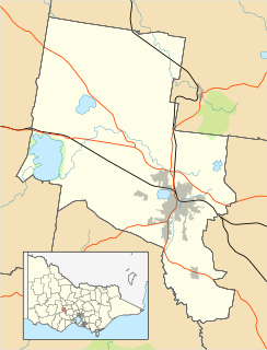
Ballarat is a city in the Central Highlands of Victoria, Australia. In 2018, Ballarat had a population of 105,471, making it the third-largest city in both Victoria and inland Australia.

Deer Park is a suburb of Melbourne, Victoria, Australia, 17 km west of Melbourne's Central Business District, located within the City of Brimbank local government area. Deer Park recorded a population of 18,126 at the 2016 Census.
Bell Park is a residential suburb of Geelong, Victoria, Australia. It is located 3 km north-west of the Geelong city centre and is bordered to the north by the Ballarat rail line, to the east by Thompson Road, to the south by the Midland Highway and to the west by Anakie Road.

Creswick is a town in west-central Victoria, Australia 18 kilometres north of Ballarat and 122 km northwest of Melbourne, in the Shire of Hepburn. It is 430 metres above sea level. At the 2016 census, Creswick had a population of 3,170. Creswick was named after the Creswick family, the pioneer settlers of the region.

Alfredton is a suburb of Ballarat, Victoria, Australia, west of the CBD. The population at the 2016 census was 9,220 making it the third most populated in the Ballarat urban area.

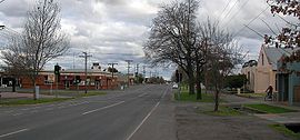
Ballarat East is a suburb of Ballarat in Victoria, Australia. From 1857 until 1921 the suburb was its own town with its own council, the East Ballarat Town Council. The suburb covers a large area east of the City of Ballarat. It is the oldest area in Ballarat and was the site of many goldmines, as well as the Eureka Rebellion.

Lake Wendouree is a suburb of Ballarat, Victoria, Australia located immediately west of the Ballarat central business district. It encompasses the man-made recreational lake Lake Wendouree, after which it is named. At the 2016 census, Lake Wendouree had a population of 2,882.
Black Hill is a suburb of Ballarat, Victoria, Australia in the northeast of the city. It is named after the major landmark, Black Hill, on which there was extensive and highly profitable open-cut gold mining from the early 1850s during the Victoria gold rush. The hill was originally given its indigenous name, Bowdun, by surveyor William Urquhart.
Lake Gardens is a relatively new suburb on the western rural-urban fringe of Ballarat, Victoria Australia located near Lake Wendouree and directly behind the Ballarat Botanical Gardens from which the suburb draws its name. The suburb is bounded by Gillies Street to the east, O'Donnell's Road to the west and Gregory Street West to the north. The population at the 2016 census was 1,695.

Redan is an inner suburb of Ballarat, Victoria, Australia immediately south of Ballarat Central. The population at the 2016 census was 2,889.

Sebastopol is a southern suburb on the rural-urban fringe of Ballarat, Victoria, Australia. It is the second most populated area in urban Ballarat with a population of 10,032 at the 2016 census.
Soldiers Hill is a suburb of Ballarat, Victoria, Australia located directly north of the Central Business District. At the 2016 census, Soldiers Hill had a population of 2,803.
Bakery Hill is an inner city suburb of Ballarat in Victoria, Australia. It is the smallest suburb in the city of Ballarat in terms of both area and population, which at the 2016 census was just 164 people. The area is a mix of residential and commercial, as it has been since it came into existence at the beginning of the gold rush. In the present time it is mainly known for its restaurants and pubs, as well as fast food. The suburb boundaries are that of Mair, East, Barkly, Steinfield and Peel Streets.
Golden Point is a suburb of Ballarat, Victoria, Australia located south-east of the CBD. It is the oldest settlement in Greater Ballarat. Gold was discovered at Poverty Point on 21 August 1851 by John Dunlop and James Regan, sparking the Ballarat gold rush. Golden Point was the site of what was known as the Ballarat diggings, and for at least a decade the focal point of the original Ballarat township was Main Street. At the 2016 census, Golden Point had a population of 2,107.

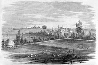
Mount Pleasant is the oldest residential suburb of Ballarat, Victoria, Australia. It is located on the southern extremity of the city between the Yarrowee Creek and the White Horse Range. Physically it is largely cut off from the rest of Ballarat which contributes to a sense of a suburb apart. The traditional Wathaurung country was first settled in 1836 when the Yuille brothers established a sheep run that included the sheltered corner under the escarpment later named Mount Pleasant. In those days, before there was a town at Ballarat, Buninyong was the nearest township. When the gold rush of 1851 brought thousands of diggers to nearby Golden Point, Mount Pleasant was left alone as no gold was initially found there. Its peacefulness made it attractive to a number of Cornish miners and their families who had come to Australia to settle permanently. These Wesleyans were the founders of the community. As devout and sober church people they sought a place to live away from the drunken mayhem of the diggings around Main Road.
Eureka is a small eastern suburb of Ballarat, Victoria, Australia – (AU). It was originally part of Ballarat East but became its own suburb in 1946 in recognition of the area's significance to Australian history. Eureka is bordered by Specimen Creek to the north, Canadian Creek to the south, Queen and Joseph streets to the west and Kline and Stawell Street to the east. The suburb takes its name from the Eureka Lead – a lead is an ancient river bed that contains gold – of the Eureka Mining Company and is most notable as the site of the historic event of the Eureka Rebellion. This was the site where the rebel miners flew the Eureka Flag for the first time; a flag that has since become a symbol of the working class and trade union movement and, at times, Australian republicanism.
Delacombe is a large and rapidly growing industrial/residential suburb on the south west rural-urban fringe of Ballarat, Victoria, Australia. The population at the 2016 census was 6,297 making it the fourth most populated in the Ballarat urban area.
Mount Clear is a semi-rural suburb of Ballarat, Victoria, Australia south of the CBD in the Canadian Creek Valley. At the 2016 census, Mount Clear had a population of 3,390.
Bullarook is a locality in the Central Highlands in Victoria, near Ballarat.

Happy Valley is a town located in the Local Government Area of the Golden Plains Shire. It shares the same name with Happy Valley in Northern Victoria.