The Harry S. Truman National Historic Site preserves the longtime home of Harry S. Truman, the 33rd president of the United States, as well as other properties associated with him in the Kansas City, Missouri metropolitan area. The site is operated by the National Park Service, with its centerpieces being the Truman Home in Independence and the Truman Farm Home in Grandview. It also includes the Noland home of Truman's cousins, and the George and Frank Wallace homes of Bess Truman's brothers. The site was designated a National Historic Site on May 23, 1983.

This is a list of the National Register of Historic Places listings in St. Louis County, Missouri.

This is a list of properties and historic districts in Missouri on the National Register of Historic Places. There are NRHP listings in all of Missouri's 114 counties and the one independent city of St. Louis.

Ward Parkway is a boulevard in Kansas City, Missouri, United States. Ward Parkway begins at Brookside Boulevard on the eastern edge of the Country Club Plaza and travels west 2.8 miles along Brush Creek as U.S. Route 56 before turning south near Kansas-Missouri state line. It continues south for 4 miles, terminating at Wornall Road near Bannister Road. A short spur, Brush Creek Parkway, connects Ward Parkway to Shawnee Mission Parkway at State Line Road.
Nichols House may refer to:
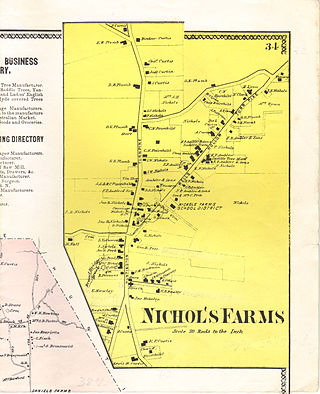
Nichols Farms is a historic area within the town of Trumbull, Connecticut. The Nichols Farms Historic District, which encompasses part of the area, is listed on the National Register of Historic Places.
Brookside is a collection of neighborhoods located in Kansas City, Missouri, bounded by 55th Street on the North, Gregory on the South, Ward Parkway on the West, and Troost on the East. The neighborhood contains the Brookside Shopping District.

The Centre Harbor Village Historic District encompasses the historic village of Center Harbor, New Hampshire. It consists of a small cluster of properties located north of Plymouth Street and Main Street, as well as the Nichols Memorial Library, and the Kona Fountain, which is located in the center of that intersection. It was added to the National Register of Historic Places in 1983.
This is a list of the National Register of Historic Places listings in Carter County, Missouri.

This is a list of the National Register of Historic Places listings in St. Charles County, Missouri.

This is a list of the National Register of Historic Places listings in Taney County, Missouri.
Missouri State Fair Speedway is a half-mile (.805 km) dirt oval race track located at the Missouri State Fair grounds in Sedalia, Missouri. The track was built along with the fairgrounds in 1901 as a one-mile (1.6-km) horse racing track. The first auto races were held in 1914 and 1915. Cars returned from 1935 until 1941, and again from 1946 until 1985 and 1989 until the mile was abandoned in 1998. One USAC National Championship race was held on the mile in 1970, won by Al Unser.

This is a list of the National Register of Historic Places listings in Shannon County, Missouri.
Nelle Elizabeth Nichols Peters (1884–1974) was one of Kansas City's most prolific architects.

This is a list of the National Register of Historic Places listings in Atchison County, Missouri.

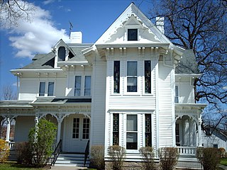
Samuel Nichols House is a historic residence located in rural Muscatine County, Iowa, United States near the town of Nichols. It has been listed on the National Register of Historic Places since 1978.
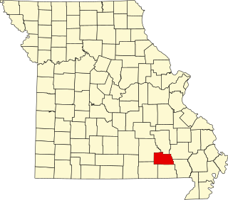
The Osage Farms Resettlement Properties in Pettis County, Missouri is a National Register of Historic Places multiple property submission located at Pettis County, Missouri. The submission includes 10 national historic districts and 2 individual properties listed on the National Register of Historic Places. The properties included were built by the Resettlement Administration / Farm Security Administration in 1937 as model farms and known as Osage Farms. Model farmsteads typically included a 1+1⁄2-story frame dwelling, barn, poultry house and privy.

Walter Klepzig Mill and Farm is a historic farm and sawmill and national historic district located in the Ozark National Scenic Riverways near Eminence, Shannon County, Missouri. The district encompasses three contributing buildings, three contributing sites, and one contributing structure associated with an early-20th century Ozark farm and mill. It developed between about 1912 and 1936 and includes the mill and its related hydraulic system ; a spring house and smokehouse ; foundations of a 1923 farmhouse and barn ; and two post-1934 chicken coops and a ruin of a post-1934 machine shed.

The Ijem Avenue Commercial Historic District is a historic district in Nichols, Iowa. It was listed on the National Register of Historic Places in 2020. It is composed of 12 one and two-story commercial buildings that date from the late nineteenth to the mid-twentieth century. It also includes one modern infill building. Nichols is a small town in western Muscatine County and was an important railroad shipping point and market town from about 1885 to about 1920. It was located along the Burlington, Cedar Rapids and Northern Railway, which came to town in 1871, and the Muscatine and Western Railroad, which arrived two years later. The two railroads intersected on the west side of the central business district, and both were incorporated into the Chicago, Rock Island and Pacific Railroad in the 1880s. The brick commercial buildings in the historic district were built during this period of time. They are attached one and two-story brick structures. The oldest buildings reflect the Italianate style with their arched windows, while the later buildings reflect the Neolassical and Commercial styles.


