North-South Motorway

Last updated

North-South Motorway
South Australia
15 - 4A9 Port River Expy-M2 North South Mwy interchange signage.jpg
Signage at the interchange of the M2 North South Motorway/A9 Port River Expressway/A13 Salisbury Highway.
General information
Type Motorway
Route number(s) AUS Alphanumeric Route M2.svg M2 [1]
Major junctions
 
Highway system

The North-South Motorway is an incomplete planned motorway traversing the inner western suburbs of Adelaide from Wingfield in the north to Bedford Park in the south. It is planned to be a non-stop north-south route overlaying the same motor traffic corridor as South Road by grade separation. The motorway is to be the central section of Adelaide's North–South Corridor, being flanked north and south by the Northern Expressway (including the Northern Connector under construction) and Southern Expressway, respectively.

Adelaide City in South Australia

Adelaide is the capital city of the state of South Australia, and the fifth-most populous city of Australia. In June 2017, Adelaide had an estimated resident population of 1,333,927. Adelaide is home to more than 75 percent of the South Australian population, making it the most centralised population of any state in Australia.

Wingfield, South Australia Suburb of Adelaide, South Australia

Wingfield is a suburb situated north of Adelaide. It lies between the Port River Expressway on the north and Grand Junction Road on the south. The suburb borders Dry Creek to its north and east, bounded by the Gawler railway line and Adelaide-Port Augusta railway line on the east. The North-South Motorway and Dry Creek-Port Adelaide railway line both cross the suburb. Wingfield is named after R. W. Wingfield, the private secretary to Governor of South Australia, William Jervois.

Bedford Park, South Australia Suburb of Adelaide, South Australia

Bedford Park is a southern suburb of Adelaide in South Australia.

Contents

Purpose

The Australian Government, through the Nation Building Program project, committed $500 million and the South Australian Government $432 million to the North–South Corridor over five years. This funding allocation recognised that South Road is the only continuous link between the northern and southern suburbs as well as the spine connecting Adelaide’s major inter-modal transport hubs – Adelaide Airport, Islington Rail Terminal, Port Adelaide and Outer Harbor. [2]

South Australia State of Australia

South Australia is a state in the southern central part of Australia. It covers some of the most arid parts of the country. With a total land area of 983,482 square kilometres (379,725 sq mi), it is the fourth-largest of Australia's states and territories by area, and fifth largest by population. It has a total of 1.7 million people, and its population is the second most highly centralised in Australia, after Western Australia, with more than 77 percent of South Australians living in the capital, Adelaide, or its environs. Other population centres in the state are relatively small; Mount Gambier, the second largest centre, has a population of 28,684.

North–South Corridor, Adelaide road route in and beyond Adelaide, South Australia

The North–South Corridor is a series of road projects currently under construction or planning which travel through Adelaide, South Australia that will eventually form a continuous link from Old Noarlunga in the outer southern metropolitan Adelaide suburbs through to Nuriootpa in the inner northern rural area around the Barossa Valley, a distance of over 100 km, aiming to be without a single stop by 2030.

Adelaide Airport airport in Adelaide, Australia

Adelaide Airport is the principal airport of Adelaide, South Australia and the fifth-busiest airport in Australia, servicing just over eight million passengers in the financial year ending 30 June 2017. Located adjacent to West Beach, it is approximately 6 km (3.7 mi) west of the city centre. It has been operated privately by Adelaide Airport Limited under a long-term lease from the Commonwealth Government since 29 May 1998.

Planning

As of October 2018 the planned motorway is divided into five sections for the purposes of construction, three of which are unconstructed or incomplete. From north to south the sections are labelled:

South Road Superway

General information
Opened 13 March 2014
Major junctions
A9 Salisbury Highway, Wingfield, Adelaide
Australian national highway A2.svg South Road, Regency Park, Adelaide
Location(s)
Major suburbs / towns Dry Creek, Wingfield, Angle Park, Regency Park
Highway system

The South Road Superway is an elevated motorway in the northern suburbs of the South Australian capital city of Adelaide. [1] The 2.8 km elevated roadway rises just north of Taminga Street, Regency Park and goes over Days Road, before access ramps at Grand Junction Road, then continues over Cormack Road and the Dry Creek railway line to join the intersection of the Port River Expressway, Salisbury Highway and in the future, the Northern Connector. In 2009, an announcement was made to build an $812-million elevated roadway above South Road from just north of Regency Road to the end of South Road where it joins to the Port River Expressway and Salisbury Highway. It was constructed over a 4 km section of South Road at a cost of A$812 million and opened in early 2014. The Superway was the biggest single investment in a road project in South Australia's history. [3] The Superway was the second stage of the North–South Corridor upgrade and delivered a 4.8 kilometre section of freeway grade road, including a 2.8 kilometre elevated roadway, from the Port River Expressway to Regency Road. Along the way, it passes over the Dry Creek-Port Adelaide railway line, Cormack Road, Grand Junction Road and Days Road, with exits at Grand Junction Road and Days Road. The Superway will continue northwards through the Dry Creek salt pans once the Northern Connector is completed at its northern end.

Regency Park is an inner-northern suburb of Adelaide, 8 km from the City Centre, in the state of South Australia, Australia. It is located in the City of Port Adelaide Enfield, and is adjacent to Wingfield, Angle Park, Ferryden Park, Kilburn, Prospect, Dudley Park and Croydon Park. It is bounded to the north by Grand Junction Road, east by the Gawler railway line, south by Regency Road and to the west by Days and South Roads. The postcode for Regency Park is 5010.

Grand Junction Road is the longest east–west thoroughfare in the Adelaide metropolitan area, and is located approximately 8 kilometres north of the Adelaide city centre. Travelling from the Port Adelaide region, it is mostly a double-lane sealed road running 21 kilometres to the base of the Adelaide Hills. The western end at the intersection of Old Port Road, 300 metres east of a causeway which separates the Port River from West Lakes. The 2.4 kilometre section of road that continues west of Old Port Road to Semaphore South is named Bower Road. The eastern end of Grand Junction Road is in the suburb of Hope Valley, at the intersection of Hancock Road and Lower North East Road, just before the latter proceeds into the Adelaide Hills, past Anstey Hill Recreation Park and on towards the towns of Houghton and Inglewood.

The Dry Creek to Port Adelaide railway is an eight-kilometre east–west line running through Adelaide’s north-western suburbs. The line is managed by the Australian Rail Track Corporation (ARTC) and is an important link between Port Adelaide, Pelican Point and the main interstate rail routes which link Adelaide with Melbourne, Perth, Darwin and Sydney. Prior to 1988, a limited local passenger service operated, stopping at five intermediate stations along the line. Since May 1988, the line has been freight-only.

Construction

South Australian civil engineering and construction company, Bardavcol, was awarded the early works local roads contract for the South Road Superway, with the design and construction contract awarded to Urban Superway Joint Venture, comprising the John Holland Group, Macmahon Contractors and Leed Engineering & Construction. [4]

John Holland Group

The John Holland Group is a construction, tunnelling, rail, building and services provider with operations in Australia, New Zealand, South East Asia and the Middle East. Headquartered in Melbourne, it is a 100% owned subsidiary of China Communications Construction Company, a Chinese state owned enterprise.

Construction of the local connector roads was completed in early 2011, with the completion of construction of Gallipoli Drive. This road replaced South Road as the main distributor road in the area during construction. Construction of the superway proper commenced in early 2011. [5] Construction was completed March 2014. The southbound lanes opened early February 2014, with the left turn entry from Port River Expressway opening on 31 January 2014. [6] The northbound lanes opened on 13 March 2014. [7]

The South Road Superway taking shape at Days Road intersection, in April 2012 NSCSouthSup1.jpg
The South Road Superway taking shape at Days Road intersection, in April 2012

T2T exits

LGALocationkmmiDestinationsNotes
Port Adelaide Enfield Wingfield 00.0AUS Alphanumeric Route A9.svg Salisbury Highway (A9) east / Port River Expressway (A9) west   Port Adelaide, Outer Harbor, Salisbury Northern terminus: continues as AUS Alphanumeric Route A9.svg Salisbury Highway to Australian national highway A1.svg Port Wakefield Road. Will continue to Northern Connector from late 2019
1.91.2Australian national highway A16.svg Grand Junction Road   Regency Park Southbound exit, Northbound entry only
Regency Park 3.42.1 South Road   Regency Park Northbound exit, southbound entry only
4.83.0AUS Alphanumeric Route A2.svg South Road  Adelaide CBD Southern terminus: continues as AUS Alphanumeric Route A2.svg South Road

Regency Road to Pym Street

Connecting the South Road Superway to the T2T lowered motorway, this short section of road currently has two traffic light intersections (including Regency Road), a controlled pedestrian crossing, and access to local side streets. It was reported in May 2017 that completion of this section would cost $400 million, with construction beginning at the start of 2019 and completed by the middle of 2022. This would complete 47 km of freeway from Gawler to the River Torrens. The state government said it was seeking 85% of the cost to be funded by the federal government, which had not committed to the spend. [8] Completion of this section was committed by the state and federal governments on 1 May 2018. The announcement stated that the cost would be A$354m but did not state an expected completion date. It will include an overpass of Regency Road and a pedestrian and cycling connection over the freeway near Pym Street. There will be three lanes each way on the non-stop road and another two lanes each way on the surface road to provide access to community and businesses. [9]

T2T lowered motorway

Southbound on North-South Motorway, about to go under the Port Road bridge.jpg
In the lowered motorway of the North-South Motorway in Adelaide, two days after the Torrens to Torrens section opened to traffic. This photo is southbound, showing the Port Road bridge
General information
Opened 29 September 2018
Major junctions
Pym Street, Croydon Park
Torrens River, West Hindmarsh
Location(s)
Major suburbs / towns Ridleyton, Croydon, Hindmarsh
Highway system

Around 2007, there were plans to construct a tunnel under Grange Road, Port Road and the Outer Harbor railway line, and construction was to start after the underpass had finished, but these plans were later scrapped. In 2013 the State Labor government in partnership with the Federal Labor government announced an upgrade from Torrens Road to the Torrens River, upgrading approximately 4 km. The upgrade would feature a new, lowered road under Grange and Port Roads. This will provide a non-stop route through the area for passing traffic and reduce delays to east-west travel. A parallel surface road along the length of the lowered road to connect the majority of local roads and arterial roads to South Road as they do now and a rail overpass of South Road for the Outer Harbor line to ensure the service doesn't interrupt traffic along the new route. Construction started in 2015, with the project expected to be completed by the end of 2018. [10] [11]

The project work was extended in December 2015 to include an underpass of Torrens Road, at no additional project cost or time. [12]

The lowered motorway opened to traffic on 29 September 2018. [13] [14] [15]

The northbound entrance to the Torrens River to Torrens Road upgrade of the North South Motorway (Adelaide), two days after it opened for traffic. Northbound entrance to Torrens to Torrens.jpg
The northbound entrance to the Torrens River to Torrens Road upgrade of the North South Motorway (Adelaide), two days after it opened for traffic.

Exits and interchanges

LGALocationkmmiDestinationsNotes
Port Adelaide Enfield Croydon Park South Road North-South Motorway is below-grade, between the carriageways of unnumbered South Road at ground level. Continues north as AUS Alphanumeric Route A2.svg South Road (A2)
Charles Sturt Croydon, Ridleyton Northbound entrance, southbound exit leading from/to Port Road intersection only
Ridleyton, Croydon, Hindmarsh Outer Harbor railway line
Hindmarsh, West Hindmarsh South Road North-South Motorway is below-grade, between the carriageways of unnumbered South Road at ground level. Continues south as AUS Alphanumeric Route A2.svg South Road (A2)

River Torrens to Anzac Highway

As of October 2018 no funding has been allocated to construction of the Torrens to Anzac Highway portion of the planned road corridor. This section contains it some of the busiest intersections of inner suburban Adelaide, as it goes directly past the city. It includes intersections with Henley Beach Road and Sir Donald Bradman Drive. In 2018, the possibility was raised that this section could be completed by tunnelling under the existing alignment due to the tight spaces between expensive and heritage listed properties. [16]

Anzac Highway to Darlington

Although the Anzac Highway to Darlington portion of the road corridor is intended to be upgraded to include non-stop north-south traffic flow before 2030, As of October 2018 there are no detailed plans and no funding has been allocated to construction. [17] Issues with this section include the intersection of South and Daws Roads in St Marys and the 5 intersections within less than a kilometre around Castle Plaza in Edwardstown. The Gallipoli Underpass at Anzac Highway, which is only considered an interim solution, and the grade separated junction at Cross Road, including the Seaford railway line, are anticipated to be upgraded separately in advance of the rest of this section of road. [18] :16

In August 2018, the possibility was raised that this section could be completed by tunnelling under the existing alignment. [16]

Gallipoli Underpass

Going under the Gallipoli Underpass, heading south in April 2012 NSCSouthAnz1.jpg
Going under the Gallipoli Underpass, heading south in April 2012

In 2005, along with the decision to make a free flowing South Road, a decision was made to build an underpass for South Road to go under Anzac Highway. Construction of this started in 2007, and it was named the Gallipoli Underpass, in line with the ANZAC theme. The underpass opened in March 2009, and to cut down on delays due to construction, an overpass was also built within the same time frame for the Glenelg Tram line just half a kilometre to the south, which also opened in 2009, significantly removing delays from this area.

Emerson Overpass

Approaching the Emerson Overpass, heading south in April 2012 NSCSouthCross1.jpg
Approaching the Emerson Overpass, heading south in April 2012

Between 1982 and 1984, the Emerson Crossing was built, taking South Road over Cross Road and the Seaford railway line. For a long time, this was the only grade separation on South Road, and one of very few in South Australia, removing congestion with Cross Road traffic and the railway line. Increasing frequency of commuter trains are resulting in vehicle bottlenecks that are anticipated to worsen as queues on the exit ramps to Cross Road can extend into the through lanes on South Road. The rail crossing could be closed for up to 20 minutes in the peak hour. [18] :54

Darlington Interchange

The two new bridges for carrying South Road over the Southern Expressway as part of the Darlington Upgrade of the North-South Corridor. They were built off-site the transported into position in one weekend Northbound bridges on South Road at Darlington Upgrade.jpg
The two new bridges for carrying South Road over the Southern Expressway as part of the Darlington Upgrade of the North-South Corridor. They were built off-site the transported into position in one weekend

In 2010, it was announced that an interchange would be built in Darlington, to provide better access to the Southern Expressway, as well as Flinders Medical Centre, Sturt Road and Ayliffes Road. This project was the basis for the Southern Expressway getting the go-ahead for duplication, but then in 2011, this project was scrapped, due to budget issues.

The plan was revived in 2014, [19] with early works commencing late in 2014 for an expected completion in 2018. [20]

This is the part of the bridge from South Road to Ayliffes Road that was built on the median strip and moved into to place using multi-wheeled lifters. The rest of the bridge will be built the "conventional way". Part of the Darlington Upgrade. Partially built Ayliffes Road access bridge.jpg
This is the part of the bridge from South Road to Ayliffes Road that was built on the median strip and moved into to place using multi-wheeled lifters. The rest of the bridge will be built the "conventional way". Part of the Darlington Upgrade.

A joint venture ("Gateway South") of Fulton Hogan and Laing O'Rourke was awarded the major works contract for the project in January 2016. The scope was expanded from earlier plans and will now upgrade 3.3 kilometres (2.1 mi) of Main South Road by creating a lowered non-stop road with surface-level service roads. There will be three lanes each way connecting from the Southern Expressway and the lowered road, which will pass underneath Flinders Drive (access to Flinders University and Flinders Medical Centre), Sturt Road, a bridge connecting Mimosa Terrace (Clovelly Park) and Sutton Road (Bedford Park) mainly for local traffic, grade separation at the Ayliffes Road and Shepherds Hill Road junction, and at Tonsley Boulevard. It will also provide separate cycling and pedestrian paths on each side of the corridor. The associated Flinders Link Project will extend the Tonsley railway line across this corridor to Flinders Medical Centre. [21]

See also

Australia road sign W5-29.svg Australian Roadsportal

Related Research Articles

Adelaide Metro South Australian public transport authority

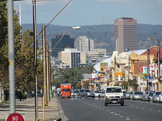
Adelaide Metro is the public transport system of Adelaide, the capital city of South Australia. It is an intermodal system offering an integrated network of bus, tram, and train service throughout the metropolitan area to 63 million riders annually, with an average daily ridership of 173,000 people. The system has evolved heavily over the past fifteen years, and patronage increased dramatically during the 2014–15 period, a 5.5 percent increase on the 2013 figures due to electrification of frequented lines.

O-Bahn Busway

The O-Bahn Busway is a guided busway that is part of the bus rapid transit system servicing the northeastern suburbs of Adelaide, South Australia. The O-Bahn system was conceived by Daimler-Benz to enable buses to avoid traffic congestion by sharing tram tunnels in the German city of Essen.

Southern Expressway (South Australia) expressway in Adelaide, South Australia

The Southern Expressway is an 18.5 km (11.5 mi) freeway in the southern suburbs of Adelaide, South Australia, between Bedford Park and Old Noarlunga.

Controlled-access highway Highway designed exclusively for high-speed vehicular traffic, with all traffic flow and ingress/egress regulated

A controlled-access highway is a type of highway which has been designed for high-speed vehicular traffic, with all traffic flow ingress- and egress-regulated. Common English terms are freeway, motorway and expressway. Other similar terms include Interstate and parkway. Some of these may be limited-access highways, although this term can also refer to a class of highway with somewhat less isolation from other traffic.

South Road, Adelaide road in Adelaide, South Australia

South Road, also known as Main South Road, is a major north–south conduit in Adelaide and Fleurieu Peninsula in South Australia. It is one of Adelaide's most important arterial and bypass roads.

Transport in Adelaide

The metropolitan area of Adelaide, South Australia is served by a wide variety of transport. Being centrally located on the Australian mainland, it forms a hub for east-west and north-south routes. The road network includes major expressways such as the Southern Expressway, the South Eastern Freeway, the Port River Expressway, the Northern Expressway and the South Road Superway. The city also has a public transport system managed by Adelaide Metro, consisting of a contracted bus system including the O-Bahn Busway, six metropolitan railway lines, and the Glenelg-Adelaide-Hindmarsh Tram. According to a study conducted by the Australian Bureau of Statistics, Adelaide has the highest passenger vehicle travel to work (84%) and the second lowest proportion of people walking to work (2.9%)–something that is being combated by the South Australian government in an effort to increase citizen ridership and use of public transport.

Metropolitan Adelaide Transport Study

The Metropolitan Adelaide Transport Study, or "MATS Plan" as it became known, was a comprehensive transport plan released in 1968 proposing a number of road and rail transport projects for the metropolitan area of Adelaide, South Australia.

National Highways Development Project project to upgrade major highways in India

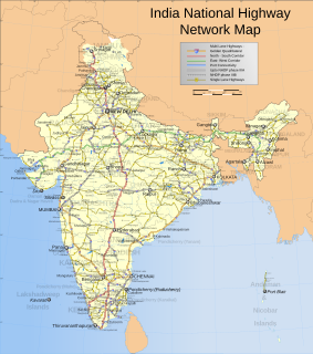
The National Highways Development Project (NHDP) is a project to upgrade, rehabilitate and widen major highways in India to a higher standard. The project was started in 1998 under the leadership of then Prime Minister, Atal Bihari Vajpayee. National Highways account for only about 2% of the total length of roads, but carry about 40% of the total traffic across the length and breadth of the country. This project is managed by the National Highways Authority of India (NHAI) under the Ministry of Road, Transport and Highways. The NHDP represents 49,260 km of roads and highways work and construction in order to boost economic development of the country. The government has planned to end the NHDP program in early 2018 and consume the ongoing projects under a larger Bharatmala project.

The Port River Expressway is a 5.5-kilometre (3.4 mi) freeway-grade road. The expressway links Port Adelaide and the LeFevre Peninsula to the northern suburbs of Adelaide and major interstate routes via Salisbury Highway (A13) to Port Wakefield Road (A1) and the Max Fatchen Expressway (M20) to Perth, Darwin and Sydney.

M4 Western Motorway Motorway in Sydney

The M4 Western Motorway is a 46-kilometre-long (29 mi) dual carriageway motorway in western Sydney, New South Wales, Australia. The partially-tolled motorway stretches from North Strathfield in the east, where it connects with the Great Western Highway/Parramatta Road as the A4 to Glenbrook in west, where it continues as the Great Western Highway as the A32.

Port Road, Adelaide road in Adelaide

Port Road is a major road in Adelaide, South Australia connecting the Adelaide city centre with Port Adelaide. It is 12 km (7.5 mi) long, and has a very wide median strip, giving a total width of approximately 70 m.

Hunter Expressway freeway in New South Wales

The Hunter Expressway is a 39.5-kilometre (24.5 mi) long dual carriageway freeway in New South Wales, Australia. It was previously known as the F3 to Branxton link or Kurri Kurri Corridor during the planning stage. It has two lanes in each direction, running generally north west from the Pacific Motorway at the Newcastle Link Road interchange to the eastern end of the Belford Bends Deviation on the New England Highway north of Branxton. The road allows traffic to bypass the Maitland area, Lochinvar, Greta and Branxton. The expressway opened on 22 March 2014.

This is a list of freeways in Australia, sorted by states and territories and their corresponding routes. This list includes tollways / toll roads such as the CityLink freeway system in Melbourne. This list has over 70 entries. The only jurisdiction in Australia without freeways is the Northern Territory. Victoria has the largest and densest freeway network in Australia.

The Northern Connector is a 15 kilometre long expressway under construction in Adelaide, South Australia. It will connect the North-South Motorway at Wingfield to the Northern Expressway (M2) as part of an ongoing plan to develop a continuous freeway grade road between Old Noarlunga and Nuriootpa known as the North–South Corridor. The road will be built with three lanes in each direction and provide a faster, safer and less congested route over the section of the North-South Corridor between South Road and the Northern Expressway. Construction began in January 2016 with completion in December 2019.

Hobart Area Transportation Study

The Hobart Area Transportation Study was a comprehensive transport plan released in 1965 for the purpose of examining the transport needs of the Australian Hobart metropolitan area over the proceeding 20 years. The study predicted the majority of the proposed traffic corridors would need to be operational by the 1985 target year.

NorthConnex is a 9-kilometre (5.6 mi) motorway tunnel under construction in northern Sydney, New South Wales, Australia. When completed in 2020, it will connect the M1 Pacific Motorway to the M2 Hills Motorway. It was previously known as the F3 to M2 link, then the M1 to M2 link after alpha numeric route numbers began to be used in New South Wales. The road has also colloquially been referred to as the "missing link", because its construction will complete the combination of the Sydney Orbital Network and its north-south motorway links to the National Highway.

York Civil was a South Australian construction and civil engineering company based in Adelaide, South Australia. It was founded in 1990 by Ian Tarbotton, who remains an owner and director along with Dominic Vieceli. It began with only 10 employees, but said it had over 400 by 2017 with offices in four states and 190 when it was wound up in August 2018.

References

  1. 1 2 Department of Planning, Transport and Infrastructure (13 March 2014). "Use the South Road Superway and save time: Northbound lanes to open on Thursday night" (PDF). Media Release. Government of South Australia. Archived (PDF) from the original on 7 May 2014. Retrieved 7 May 2014.
  2. Australian Government (26 June 2010). "Nation Building - Economic Stimulus Plan" . Retrieved 26 June 2010.
  3. Infrastructure SA (21 May 2010). "South Road Superway: Demography" . Retrieved 26 June 2010.
  4. Infrastructure SA (30 April 2010). "Project Overview: Demography" . Retrieved 29 June 2010.
  5. Infrastructure SA (30 April 2010). "Project official webpage" . Retrieved 29 June 2010.
  6. Infrastructure SA (30 April 2010). "Project official webpage" . Retrieved 2 February 2014.
  7. "South Road Superway". Department of Planning, Transport and Infrastructure. 14 March 2014. Retrieved 1 September 2014.
  8. Wills, Daniel (15 May 2017). "South Rd upgrade: Construction to start between Regency Rd and Pym St". The Advertiser. Retrieved 28 February 2018.
  9. "Regency Road to Pym Street". Department of Planning, Transport and Infrastructure . Retrieved 30 April 2018.
  10. "North-South Corridor: Torrens Road to River Torrens". Department of Planning, Transport and Infrastructure, Government of South Australia. 5 August 2015. 145594. Retrieved 8 August 2015.
  11. "T2T". T2T Alliance. 31 July 2015. Retrieved 8 August 2015.
  12. "Torrens Road to Torrens River Project Scope Extension". Department of Planning, Transport and Infrastructure. Retrieved 12 December 2015.
  13. "Torrens to Torrens Part of South Road Upgrade to Open This Weekend". AdelaideNow. Retrieved 1 October 2018.
  14. "TORRENS ROAD TO RIVER TORRENS LOWERED MOTORWAY TO OPEN TO TRAFFIC" (PDF). Government of South Australia. 28 September 2018.
  15. "North-South Corridor open to traffic". RoadsOnline.com.au. 1 October 2018.
  16. 1 2 Smith, Matt (10 August 2018). "State Government puts the possibility of tunnels back on the table for North-South corridor". The Advertiser. Retrieved 3 September 2018.
  17. "South Road Planning (Anzac Highway to Southern Expressway)". Department of Planning, Transport and Infrastructure. Retrieved 6 April 2016.
  18. 1 2 "North–South Corridor The 10 year Strategy" (PDF). Department of Planning, Transport and Infrastructure. May 2015. K-Net #9526649, V1. Retrieved 6 April 2016.
  19. "Darlington Upgrade Project". Department of Planning, Transport and Infrastructure. 5 September 2014. Retrieved 19 December 2014.
  20. "What's next". Department of Planning, Transport and Infrastructure. 3 December 2014. Retrieved 19 December 2014.
  21. "Darlington Upgrade Project". Department of Planning, Transport and Infrastructure . Retrieved 3 September 2018.