Portrush Road, Adelaide

Last updated

National Highway A17

Portrush Road / Lower Portrush Road / Ascot Avenue / Taunton Road / Hampstead Road

Portrush Road, Adelaide
Australia Greater Adelaide location map.svg
Red pog.svg
North end
Red pog.svg
South end
Coordinates
General information
Type Highway
Length15 km (9.3 mi)
Route number(s) AUS Alphanumeric Route A17.svg A17 (2017-present)
Former
route number
Australian national highway A17.svg National Highway A17 (1998-2017)
Major junctions
North endAUS Alphanumeric Route A16.svg Grand Junction Road
Northfield, Adelaide
 
South endAUS Alphanumeric Route M1.svg South Eastern Freeway
Glen Osmond, Adelaide
Location(s)
Major settlementsHampstead RoadTaunton RoadAscot AvenueLower Portrush RoadPortrush Road
Highway system

Portrush Road is a major bypass route in Adelaide, the capital of South Australia, and is allocated route A17. [1]

Contents

Route description

It runs north–south through the south-eastern and eastern suburbs of Adelaide, at the foot of the Adelaide Hills. The southern end is at the beginning of National Route M1 , the South Eastern Freeway (the major route from Melbourne and the south-east of South Australia), which is also the intersection with the south-eastern ends of Cross Road (State Route A3 ) and Glen Osmond Road (State Route A1 ).

Portrush Road extends north from there to Payneham Road (State Route A11 ), crossing the four major arterial routes from the south-eastern and eastern suburbs into the city: Greenhill Road, Kensington Road, The Parade and Magill Road. Portrush road carries approximately 36,000 vehicles per day, including heavy freight trucks. [2] It is an authorised route for trucks up to 26 metres (85 ft) B-double and 25 metres (82 ft) vehicle carrier size. [3]

Had the Metropolitan Adelaide Transport Study of the 1960s progressed, a Hills Freeway would have been constructed to link the South Eastern Freeway to the Port of Adelaide. This would have subsequently removed the freight that utilises Portrush Road (and the A17 Route altogether) today.

A17

At Payneham Road, the A17 turns north-west and changes name to Lower Portrush Road. As it crosses the River Torrens, it changes name to Ascot Avenue. At the intersection with North East Road (State Route A10 ), it changes name to Taunton Road. At the end of Taunton Road, it turns north again joining Hampstead Road, continuing north and terminating at the intersection with Grand Junction Road, (National Route A16 ).

The A17 (Portrush Road - Hampstead Road) and the A16 (Grand Junction Road) constitute the major heavy road transport route through suburban Adelaide from Port Adelaide and anywhere north of Adelaide to the South East of South Australia and the adjacent state of Victoria.

History

Portrush Road was named by Nathaniel A. Knox after Portrush in Northern Ireland. Knox owned land near the intersection with Greenhill Road, in the area now occupied by the suburbs of Glenunga and Glenside. [4]

In a 1949 street directory, the southern end of Portrush Road had its current route to Kensington Road. North of Kensington Road, it took the name Kensington Terrace, then Wellington Road north of the Magill Road intersection to Payneham Road. What is now Lower Portrush Road (including the bridge over the River Torrens) did not exist at all. Ascot Avenue was a minor street running off of North East Road which did not exactly line up with Taunton Road on the other side of North East Road. The nearest bridge over the River Torrens was the Felixstow Bridge on Felixstow Road, which is now O.G. Road. [5] Lower Portrush Road and the bridge across the Torrens was opened in November 1970. [6]

Major intersections in National Route A17

LGALocation [7] kmmiDestinationsNotes
City of Unley, City of Mitcham, City of Burnside Glen Osmond, Myrtle Bank, Urrbrae 00.0AUS Alphanumeric Route A1.svg Glen Osmond RoadAdelaide city centre / AUS Alphanumeric Route A3.svg Cross RoadGlenelg / AUS Alphanumeric Route M1.svg South Eastern FreewayMurray Bridge Southern end of Portrush Road and southern terminus of A17
Burnside Toorak Gardens, Tusmore, Linden Park, Glenside AUS Alphanumeric Route B26.svg Greenhill RoadEastwood
City of Burnside, City of Norwood Payneham & St Peters Kensington, Marryatville, Norwood, Toorak Gardens Kensington RoadAdelaide city centre
Beulah Park, Kensington, Norwood The Parade
Maylands, Trinity Gardens, Beulah Park, Norwood AUS Alphanumeric Route B27.svg Magill RoadAdelaide city centre
Norwood Payneham & St Peters Marden, Payneham AUS Alphanumeric Route A11.svg Payneham RoadCampbelltown, Adelaide city centre
  • Portrush Road south
  • Lower Portrush Road northwest
Marden O-Bahn Busway
City of Norwood Payneham & St Peters, Town of Walkerville Vale Park, Marden River Torrens
  • Lower Portrush Road southeast
  • Ascot Avenue northwest
Town of Walkerville, City of Port Adelaide Enfield Manningham, Vale Park AUS Alphanumeric Route A10.svg North East RoadModbury
  • Ascot Avenue southeast
  • Taunton Road northwest
City of Port Adelaide Enfield, City of Prospect Broadview, Manningham Hampstead Road – North East Road towards city centre
  • Taunton Road southeast
  • Hampstead Road north
Port Adelaide Enfield Broadview, Greenacres, Manningham Regency RoadRegency Park / Muller Road
Gepps Cross, Northfield, Clearview AUS Alphanumeric Route A16.svg Grand Junction Road (A16) – Gepps Cross / Briens RoadNorthern end of Hampstead Road and northern terminus of A17
  •       Route transition

See also

Australia road sign W5-29.svg   Australian Roadsportal

Related Research Articles

South Eastern Freeway

The South Eastern Freeway is a 76 kilometre controlled-access highway in South Australia. It carries traffic over the Adelaide Hills between Adelaide and the River Murray, near Murray Bridge, connecting via the Swanport Bridge to the Dukes Highway which is the main road route to Victoria. It is often referred to by South Australians simply as the Freeway, as it was the first freeway in South Australia, and is still the longest, and the only one with "Freeway" in its name rather than "Expressway" or "Highway". It is a part of the National Highway network linking the state capital cities Adelaide to Melbourne and signed as National Highway M1. The South Eastern Freeway includes 500-metre-long twin-tube tunnels in the descent towards Adelaide, the first of their kind on the National Highway. It is designated as the M1.

O-Bahn Busway Guided busway in Adelaide, Australia

The O-Bahn Busway is a guided busway that is part of the bus rapid transit system servicing the northeastern suburbs of Adelaide, South Australia. The O-Bahn system was conceived by Daimler-Benz to enable buses to avoid traffic congestion by sharing tram tunnels in the German city of Essen.

Norwood, South Australia Suburb of Adelaide, South Australia

Norwood is a suburb of Adelaide, about 4 km (2.5 mi) east of the Adelaide city centre. The suburb is in the City of Norwood Payneham & St Peters, whose predecessor was the oldest South Australian local government municipality.

City of Burnside Local government area in South Australia

The City of Burnside is a local government area in the South Australian city of Adelaide stretching from the Adelaide Parklands into the Adelaide foothills with an area of 2,753 hectares. It was founded in August 1856 as the District Council of Burnside, the name of a property of an early settler, and was classed as a city in 1943. The LGA is bounded by Adelaide, Adelaide Hills Council, Campbelltown, Mitcham, Norwood Payneham and St Peters and Unley.

Transport in Adelaide

The metropolitan area of Adelaide, South Australia is served by a wide variety of transport. Being centrally located on the Australian mainland, it forms a hub for east–west and north–south routes. The road network includes major expressways such as the Southern Expressway, the South Eastern Freeway, the Port River Expressway, the Northern Expressway and the South Road Superway. The city also has a public transport system managed by Adelaide Metro, consisting of a contracted bus system including the O-Bahn Busway, six metropolitan railway lines, and the Glenelg-Adelaide-Hindmarsh Tram. According to a study conducted by the Australian Bureau of Statistics, Adelaide has the highest passenger vehicle travel to work (84%) and the second lowest proportion of people walking to work (2.9%)–something that is being combated by the South Australian government in an effort to increase citizen ridership and use of public transport.

Metropolitan Adelaide Transport Study

The Metropolitan Adelaide Transport Study, or "MATS Plan" as it became known, was a comprehensive transport plan released in 1968 proposing a number of road and rail transport projects for the metropolitan area of Adelaide, South Australia.

Fullarton Road is a main road in the South Australian capital city of Adelaide.

History of the City of Burnside History of area in Adelaide, Australia

The history of the City of Burnside, a local government area in the metropolitan area of Adelaide, spans three centuries. Prior to European settlement Burnside was inhabited by the Kaurna people, who lived around the creeks of the River Torrens during the winter and in the Adelaide Hills during the summer.

The Port River Expressway is a 5.5-kilometre (3.4 mi) freeway-grade road. The expressway links Port Adelaide and the LeFevre Peninsula to the northern suburbs of Adelaide and major interstate routes via Salisbury Highway (A9) to Port Wakefield Road (A1) and the Max Fatchen Northern Expressway (M2) to Perth, Darwin and Sydney.

Glen Osmond Road, Adelaide

Glen Osmond Road is a major section of the Princes Highway and state Highway 1 in the city of Adelaide, South Australia. Connecting the Adelaide city centre with the Adelaide Hills via the South Eastern Freeway; Glen Osmond Road carries half of Adelaide's freight traffic and is the major commuter route from the southern Adelaide Hills. It has intersections at Greenhill Road, Fullarton Road, Cross Road and Portrush Road.

Buses in Adelaide Adelaide buses information

Buses in Adelaide comprise the most extensive service of the South Australian capital's public transport system, the Adelaide Metro. A large fleet of diesel and natural gas powered buses operate services which typically terminate in the city-centre or at a suburban interchange. Buses get priority on many roads and intersections, with dedicated bus lanes and 'B'-light bus only phases at many traffic lights.

East Torrens Messenger is a weekly suburban newspaper in Adelaide, part of the Messenger Newspapers group. The East Torrens' area is bounded by Hackney Road to the west, the River Torrens Valley to the north, Magill Road to the south and the Athelstone foothills in the east.

Lower North East Road is an arterial road in the northeastern suburbs of Adelaide, South Australia. From west to east, it consists of North Terrace through Kent Town, Payneham Road and Lower North East Road proper. It links the north-eastern corner of Adelaide to Houghton in the Adelaide Hills, and is an urban alternative to North East Road.

Adelaide has two city ring routes, that loop around the Adelaide city centre and North Adelaide, known as the Inner and Outer Ring Routes.

Regency Road is a main east-west road connecting the inner northern suburbs of Adelaide, South Australia. Located approximately 6 kilometres (3.7 mi) north of the city centre, it spans from Arndale Shopping Centre, Kilkenny in the west, to Broadview in the east, continuing eastwards as Muller Road, to end at North East Road in Klemzig. Regency Road has major intersections at Torrens Road, South Road, Churchill Road, Prospect Road, Main North Road and Hampstead Road.

The East Torrens Football Association (ETFA) was an Australian rules football competition based in the eastern and north-eastern suburbs of Adelaide, South Australia until it merged with the North Adelaide District Football Association to form the Norwood-North Football Association at the end of the 1968 season. It was formed in 1916 for the purpose of “fostering junior football in the Norwood district."

District Council of East Torrens Local government area in South Australia

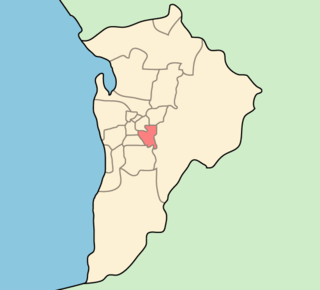
The District Council of East Torrens was a local government council of South Australia from 1853 to 1997.

City of Kensington and Norwood Local government area in South Australia

The City of Kensington and Norwood, originally the Corporate Town of Kensington and Norwood, was a local government area in South Australia from 1853 to 1997, centred on the inner eastern Adelaide suburbs of Kensington and Norwood. In November 1997 it amalgamated with the City of Payneham and the Town of St Peters to form the City of Norwood Payneham & St Peters.

References

  1. 2003 Adelaide Street Directory, 41st Edition. UBD (A Division of Universal Press Pty Ltd). 2003. ISBN   0-7319-1441-4.
  2. "Greenways and bike boulevards". Department of Planning, Transport and Infrastructure, Government of South Australia. 12 March 2015. Norwood-Magill Bicycle Boulevard. Retrieved 3 April 2015. Portrush Road is a busy freight route carrying an average of 36,000 motor vehicles per day.
  3. "RAVnet - Heavy vehicle routing, South Australia". Department of Planning, Transport and Infrastructure, Government of South Australia. Retrieved 3 April 2015.
  4. "Portrush Road". The Mail (Adelaide) . 17 (844). South Australia. 28 July 1928. p. 14. Retrieved 28 October 2016 via National Library of Australia.
  5. "Gregory's Street Directory of Adelaide and Suburbs" (1949 ed.). Retrieved 10 July 2016 via Open Street Map Australia.
  6. Notes for the Opening of the Portrush Road Bridge at Marden, 13 November 1970, retrieved 10 July 2016
  7. "Property Location Browser". Government of South Australia. Archived from the original on 12 October 2016. Retrieved 10 July 2016.
Portrush Road facing north, passing by Glenunga and Linden Park. Portrush pano.jpg
Portrush Road facing north, passing by Glenunga and Linden Park.