Port Wakefield Road

Last updated

Port Wakefield Road

Port Wakefield Road
Coordinates
General information
Type Highway
Length92 km (57 mi)
Route number(s) AUS Alphanumeric Route A1.svg A1 (2017-present)
Former
route number
  • Australian national highway A1.svg National Highway A1 (1998-2017)
  • Australian national highway 1.svg National Highway 1 (1974-1998)
  • Australian national route 1.svg National Route 1 (1955-1974)
Major junctions
North endAUS Alphanumeric Route A1.svg Augusta Highway
Port Wakefield, South Australia
 
South endAUS Alphanumeric Route A1.svgAUS Alphanumeric Route A20.svg Main North Road
Gepps Cross, Adelaide
Location(s)
Major settlements Two Wells, Virginia, Cavan, Gepps Cross
Highway system

Port Wakefield Road and Port Wakefield Highway are an important South Australian highway. They connect Adelaide to the Yorke Peninsula, Port Augusta, northern and western South Australia, the Northern Territory and Western Australia. They are designated National Highway A1 and a part of the National Highway. They are named after Port Wakefield, the first government town north of Adelaide. Historically, the whole route was named Port Wakefield Road, however following the opening of the Northern Expressway, the route north of that junction was named Port Wakefield Highway.[ citation needed ]

Contents

Location

Port Wakefield Road branches off of Main North Road at Gepps Cross in the northern suburbs of Adelaide. The route is dual-carriageway for its entire length to Port Wakefield and bypasses all of the small towns along its former route. The original bypass of Port Wakefield is now built up with roadhouses and other businesses, leading to calls to build a new bypass further east. [1]

History

The four-span bridge opened in 1926 over the Gawler railway line at Cavan was replaced with two dual carriageway bridges in 1980. [2] At the same time Virginia and Two Wells were bypassed. [3]

In 2011 an upgrade including road widening of nine kilometres of Port Wakefield Road between Salisbury Highway and Waterloo Corner Road was completed as part of the Northern Expressway project. [4]

In February 2020, the northbound ramp from Port Wakefield Road to the Northern Expressway was closed permanently as part of the final stages of opening the Northern Connector, the project name for the northernmost part of the North–South Motorway, a new freeway west of Port Wakefield Road, connecting the southern end of the Northern Expressway to the northern end of the South Road Superway. Northbound traffic to the Northern Expressway needs to use an earlier entrance to the North–South Motorway or join the Northern Expressway later via Waterloo Corner Road and Heaslip Road. [5]

The contract for detailed design and construction of duplication of the highway through Port Wakefield and grade-separated intersection with the Copper Coast Highway was let in March 2020 to the Port Wakefield to Port Augusta Alliance, a consortium of CPB Contractors, Aurecon and GHD Group. This consortium is also responsible for the duplication of Joy Baluch AM Bridge in Port Augusta. [6] [7]

Major intersections

LGALocation [8] km [9] miDestinationsNotes
Port Adelaide Enfield Blair AtholEnfieldGepps Cross tripoint 00.0AUS Alphanumeric Route A16.svg Grand Junction Road (A16 west, east)  Port Adelaide, Northfield, Holden Hill
AUS Alphanumeric Route A20.svg Main North Road (A20 north-east)  Elizabeth, Gawler, Nurioopta
AUS Alphanumeric Route A1.svg Main North Road (A1 south)  North Adelaide
Southern terminus of Port Wakefield Road; continues south as AUS Alphanumeric Route A1.svg Main North Road
Five-way traffic light intersection
Gepps Cross–Dry Creek boundary1.20.75AUS Alphanumeric Route A22.svg Cavan Road (A22)  Dry Creek, Kilburn
Salisbury Cavan 2.31.4Churchill Road North (west)  Dry Creek
Montague Road (east)  Pooraka, Para Vista
Dry Creek–Mawson Lakes boundary4.02.5AUS Alphanumeric Route A9.svg Salisbury Highway (A9)  Port Adelaide, Salisbury Diamond interchange
BolivarParalowie 9.45.8AUS Alphanumeric Route A18.svg Bolivar Road (A18), to AUS Alphanumeric Route A18.svg Kings Road (A18)  Modbury
Waterloo Corner 13.08.1Waterloo Corner Road  Salisbury, St Kilda
Playford 15.7–
17.0
9.8–
10.6
AUS Alphanumeric Route M2.svg Northern Expressway (M2 northeast)  Gawler, Renmark
AUS Alphanumeric Route M2.svg Northern Connector (M2 southwest)
Partial interchange: southbound entrances to Northern Expressway and Northern Connector, no northbound entrances to either
Virginia, Waterloo Corner 17.610.9Old Port Wakefield Road  Virginia
Virginia, Buckland Park 2314Angle Vale Road  Virginia, Angle Vale, Gawler
Adelaide Plains Two Wells 3019AUS Alphanumeric Route B77.svg Mallala Road (B77)  Two Wells, Mallala, to AUS Alphanumeric Route B77.svg Gawler Road (B77)  Gawler
Wakefield Port Wakefield 87.354.2AUS Alphanumeric Route A1.svg Augusta Highway (A1 north)  Snowtown, Port Augusta
AUS Alphanumeric Route B84.svg Port Wakefield–Auburn Road (B84 north-east)  Balaklava
North Street (west)  Port Wakefield
Northern terminus of Port Wakefield Road; continues north as AUS Alphanumeric Route A1.svg Augusta Highway
1.000 mi = 1.609 km; 1.000 km = 0.621 mi

Towns

Approximate road distances (in kilometres) of towns along the Port Wakefield Road from Main North Road, Adelaide Portwakefieldrd.png
Approximate road distances (in kilometres) of towns along the Port Wakefield Road from Main North Road, Adelaide

Port Wakefield Road passes through the northern Adelaide Plains. To the west of the road is the coastal fringe of upper Gulf St Vincent, including a number of fishing and holiday villages. To the east is rich cropping and farming land.

The list of towns on or near the road include:

See also

Australia road sign W5-29.svg   Australian Roadsportal

Related Research Articles

Princes Highway

The Princes Highway is a major road in Australia, extending from Sydney to Adelaide via the coast through the states of New South Wales, Victoria and South Australia. It has a length of 1,941 kilometres (1,206 mi) or 1,898 kilometres (1,179 mi) via the former alignments of the highway, although these routes are slower and connections to the bypassed sections of the original route are poor in many cases.

Pacific Highway (Australia)

The Pacific Highway is a 780-kilometre-long (485 mi) national highway and major transport route along the central east coast of Australia, with the majority of it being part of Australia's Highway 1. It no longer includes former sections of the highway between Brunswick Heads and Brisbane that have been legally renamed Pacific Motorway or Gold Coast Highway. As such, the highway stops short of the Queensland border near the Gold Coast.

Sturt Highway

The Sturt Highway is an Australian national highway in New South Wales, Victoria, and South Australia. The Sturt Highway is an important road link for the transport of passengers and freight between Sydney and Adelaide and the regions situated adjacent to the route.

Princes Motorway

The Princes Motorway is a 55-kilometre (34 mi) predominantly dual carriage untolled motorway that links Sydney to Wollongong and further south through the Illawarra region to Albion Park Rail. Part of the Australian Highway 1 network, the motorway is designated with the route number M1.

Southern Expressway (South Australia)

The Southern Expressway is an 18.5 km (11.5 mi) freeway in the southern suburbs of Adelaide, South Australia, between Bedford Park and Old Noarlunga. It is the southern part of the North–South Corridor which extends the full length of Adelaide and is being built to urban freeway standard.

Pacific Motorway (Brisbane–Brunswick Heads)

The Pacific Motorway is a motorway in Australia between Brisbane, Queensland, and Brunswick Heads, New South Wales, through the New South Wales–Queensland border at Tweed Heads.

Main North Road Road in South Australia

Main North Road is the major north-south arterial route through the suburbs north of the Adelaide City Centre in the city of Adelaide, South Australia. It continues north through the settled areas of South Australia and is a total of 307 kilometres (191 mi) long, from North Adelaide to 21 kilometres (13 mi) out of Port Augusta. It follows the route established in the early years of the colony by explorer John Horrocks and was a major route for farmers and graziers to reach the capital, passing through rich farmland and the Clare Valley wine region. In 2011, the section of road between Gawler to Wilmington was renamed Horrocks Highway.

Port Wakefield, South Australia Town in South Australia

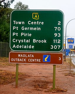
Port Wakefield is a town at the mouth of the River Wakefield, at the head of the Gulf St Vincent in South Australia. It was the first government town to be established north of the state capital, Adelaide. Port Wakefield is situated 98.7 kilometres from the Adelaide city centre on the Port Wakefield Highway section of the A1 National Highway.

South Road, Adelaide

South Road, also known as Main South Road, is a major north–south conduit in Adelaide and Fleurieu Peninsula in South Australia. It is one of Adelaide's most important arterial and bypass roads.

The Port River Expressway is a 5.5-kilometre (3.4 mi) freeway-grade road. The expressway links Port Adelaide and the LeFevre Peninsula to the northern suburbs of Adelaide and major interstate routes via Salisbury Highway (A9) to Port Wakefield Road (A1) and the Max Fatchen Northern Expressway (M2) to Perth, Darwin and Sydney.

Northern Expressway

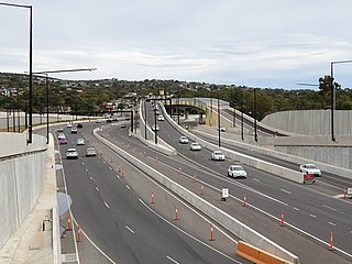
The Northern Expressway, also known as the Fatchen Northern Expressway, is a 23 kilometre long controlled-access highway in Adelaide, South Australia. It travels from Gawler to Port Wakefield Road. The road has been built to four-lane standard and provides a faster route between Adelaide and Gawler, whilst reducing the amount of traffic on Main North Road, which passes through the heart of the northern suburbs and is interspersed with frequent traffic lights. It also allows freight vehicles to avoid residential areas and go straight to Port Wakefield Road. Since March 2020, the North–South Motorway continues west of Port Wakefield Road and intersects the Port River Expressway (A9) to reach the harbour at Port Adelaide. These are the northernmost two parts of the North–South Corridor.

Gawler Bypass is a major north–south route in the outer northern suburbs of the city of Adelaide, South Australia. It had the national designation of National Highway A20 north of the Northern Expressway, while south of this intersection it had the state designation of A52. From late 2016, the entire length was designated A20, corresponding to the Northern Expressway being designated M2.

North–South Motorway

The North–South Motorway is an incomplete planned motorway traversing the inner western suburbs of Adelaide from Waterloo Corner in the north to Bedford Park in the south. Progressively constructed in stages since 2010, once complete it will replace the adjacent South Road as Adelaide's main north-south roadway and form the central section of the North–South Corridor, being flanked north and south by the Northern Expressway and Southern Expressway, respectively.

North–South Corridor, Adelaide

The North–South Corridor is a series of component motorways travelling through Adelaide, South Australia that will eventually form a continuous link from Old Noarlunga in the outer southern metropolitan Adelaide suburbs through to Gawler in northern metropolitan Adelaide, comprising a distance of 78km. Under South Australia's road route system, the corridor is signed as route M2.

Augusta Highway Highway in South Australia

The Augusta Highway is the part of Australia's ring route located in South Australia between Port Wakefield and Port Augusta. It was named Augusta Highway in 2011, and was formerly known simply as Highway One and also as the Princes Highway, despite not being continuous to the Princes Highway in the southeast of the state.

Copper Coast Highway

The Copper Coast Highway is a highway in South Australia which branches off from the Augusta Highway 2 km north of Port Wakefield and heads northwest across the top of Yorke Peninsula to Kadina and ends at the Spencer Gulf town of Wallaroo.

Yorke Highway

The Yorke Highway is the main road from Adelaide to the southern parts of the Yorke Peninsula in South Australia. It runs from the northeast to the southwest of the peninsula. It branches off of the Copper Coast Highway after rounding the top of Gulf St Vincent, runs down the coast to Ardrossan then inland through Maitland to the Spencer Gulf coast at Hardwicke Bay then through Warooka to the south coast at Marion Bay and Stenhouse Bay on Investigator Strait.

The Joy Baluch AM Bridge is a bridge across Spencer Gulf between Port Augusta and Port Augusta West in South Australia. It carries Highway 1 and is a key road link on both east–west and north–south road routes in Australia. The western end leads to Eyre Peninsula, the Eyre Highway and the Stuart Highway. The eastern end leads to the Augusta Highway towards Adelaide, Victoria and New South Wales.

References

  1. "Mid North and Yorke Peninsula" (PDF). Strategic Infrastructure Plan. Government of South Australia. April 2005. Archived from the original (PDF) on 11 May 2006. Retrieved 3 August 2006.
  2. Port Wakefield Road Closed The News 4 September 1926 page 8
  3. Upgrading for Adelaide's northern outlets Australian Transport March 1980 page 19
  4. "AusLink Projects: Northern Expressway". AusLink . Government of Australia. 14 July 2006. Archived from the original on 7 November 2007. Retrieved 3 August 2006.
  5. "Northern Expressway on-ramp – closure and detour" (PDF). North-South Corridor Northern Connector Project notification. Department of Planning, Transport & Infrastructure. February 2020. Archived (PDF) from the original on 29 February 2020. Retrieved 29 February 2020.
  6. "Port Wakefield Overpass and Highway Duplication". Department of Planning, Transport & Infrastructure . Retrieved 9 May 2020.
  7. McCormack, Michael (1 March 2020). "PORT WAKEFIELD AND JOY BALUCH UPGRADES ARE SIGNED, SEALED AND SOON TO BE DELIVERED" (PDF) (Press release). Retrieved 9 May 2020 via Department of Planning, Transport & Infrastructure.
  8. A.J.Miazzo (16 December 2013). "Naming of State Rural Roads - Mid North" (PDF). Government of South Australia. Rack Plan 869. Archived from the original (PDF) on 4 September 2014. Retrieved 17 November 2016.
  9. Google (12 June 2014). "Port Wakefield Road" (Map). Google Maps . Google. Retrieved 12 June 2014.