Novena, Singapore

Last updated

Novena
Other transcription(s)
   Chinese 诺维娜
   Malay Novena
   Tamil நொவீனா
Novena Square 3.JPG
Novena Square 2.JPG
NCID and CHI.jpg
Novena Church 3.JPG
Sun Yat Sen Nanyang Memorial Hall 5, Aug 06.JPG
Novena in Central Region, Singapore.svg
Location in Central Region
Singapore location map (main island).svg
Red pog.svg
Novena
Location of Novena within Singapore
Coordinates: 1°19′15.09″N103°50′32.75″E / 1.3208583°N 103.8424306°E / 1.3208583; 103.8424306
CountryFlag of Singapore.svg  Singapore
Region Central Region
CDCs
Town councils
  • Bishan-Toa Payoh Town Council
  • Holland-Bukit Panjang Town Council
  • Jalan Besar Town Council
  • Tanjong Pagar Town Council
Constituencies
DGP exhibited
PA incorporated
  • 22 January 1999 [1]
Government
  MayorsCentral Singapore CDC

North West CDC


  Members of ParliamentBishan-Toa Payoh GRC

Holland-Bukit Timah GRC

Jalan Besar GRC

Tanjong Pagar GRC

Area
[2]
  Total8.98 km2 (3.47 sq mi)
  Rank34th
Population
 (2019) [2] [3]
  Total49,210
  Rank25th
  Density5,500/km2 (14,000/sq mi)
   Rank26th
Demonym Official
  • Novena resident
Ethnic groups (2015)
[3]
   Chinese 38,840
   Malays 2,110
   Indians 4,210
  Others2,830
Postal district
8, 11, 12

Novena is a planning area located within the Central Region of Singapore. Novena is bounded by Toa Payoh to the north, Bukit Timah to the west, Tanglin to the south and Kallang to the east. While Novena is not classified as a "new town" by the Housing and Development Board (HDB), the estate of Whampoa within the subzone of Balestier constitutes part of the Kallang/Whampoa New Town.

Contents

The vicinity is named after the Novena prayer devotions to Our Mother of Perpetual Help, originally established by the Redemptorist Order that settled and propagated within the area. In later years, the Tan Tock Seng Hospital was set in 1844, one of the oldest and busiest hospitals in Singapore.

Etymology

Novena Church in the evening Church of St. Alphonsus Singapore 2011.jpg
Novena Church in the evening

Novena and its associated roads, buildings and Mass Rapid Transit station are named after Novena Church (canonically the Church of Saint Alphonsus Liguori) located in the area. [4]

Balestier Road was named after Joseph Balestier, an American diplomat who served in Singapore in the 1800s. [5]

Infrastructure

Housing

Land in Novena is very expensive because of its close proximity to the Central Area. There are few HDB flats in Novena; most houses in the area are condominiums or private housing. [6]

Healthcare

Novena is home to the largest concentration of hospitals and medical centres in Singapore. [7]

An integrated academic medical complex termed HealthCity Novena, is centred around Tan Tock Seng Hospital, and supported by step-down facilities such as the Integrated Care Hub, Ren Ci Hospital and Dover Park Hospice as well tertiary national medical centres including the National Centre for Infectious Diseases, National Neuroscience Institute and National Skin Centre. [8] [9] The Clinical Sciences Building of the Lee Kong Chian School of Medicine and various leisure and public spaces complete the complex. [10]

A number of private healthcare providers are situated next to Tan Tock Seng Hospital. The private cluster is anchored by Mount Elizabeth Novena Hospital, with standalone outpatient clinics leveraging on network effects setting up in Novena Medical Centre, Novena Specialist Centre and Royal Square Novena.

Commercial

VeloCity@Novena Square and Square 2/Novena Medical Centre Novena SquareIMG 8340.jpg
VeloCity@Novena Square and Square 2/Novena Medical Centre

Central to this area is Novena Square, a mixed used development situated directly above the Novena MRT station. Novena Medical Centre is located at levels 8 to 11 of the Square 2 shopping centre. Adjacent to Novena Square's Office Tower is a sports-themed mall called Novena Velocity. Opposite Novena Square, and across the Junction of Newton Road, Moulmein Road and Thomson Road, is United Square Shopping Mall, a children-oriented mall, with shops catering to infants, kids and parents. Shops located in the Novena area include Starbucks (one in United Square and another in Novena Square), Cold Storage, Decathlon and the newly opened Don Don Donki at Square 2, a Japanese Discount Store. Banks located in the Novena area include POSB and UOB. Novena has seen major improvements in terms of new shops opening in the area since Square 2 and Velocity commenced business in recent years.

Novena Square

Velocity@Novena Square, formerly known as Novena Square, is a sports and lifestyle mall with a new building extension. It lies directly above Novena MRT station. It was opened in December 2000, and owned by Novena Square Investments. There are 160 stores and spans 3 floors.

Square 2

Square 2 is located at the Novena MRT station. It was opened on 10 December 2007, and it is developed and owned by Far East Organization. It has over 180 specialty stores, selling food and beverage, fashion and accessories, education and enrichment, as well as beauty & wellness services, spanning five floors.

Education

Novena has a total of three primary schools, three secondary schools, three private schools and two schools offering tertiary education as of 2024. The list is as follows:

Primary schools

Secondary schools

Tertiary institutions

Other schools

Transportation

Novena is accessible by MRT, with buses serving the city, nearest neighbouring estates and is close proximity to the expressway. The area has no bus interchange, the nearest being in Toa Payoh. However, Saint Michael's Bus Terminal can be found along Balestier.

See also

Related Research Articles

<span class="mw-page-title-main">Ang Mo Kio</span> Planning Area and HDB Town in Singapore

Ang Mo Kio is a planning area and residential town situated in the North-East region of Singapore. Located approximately 11 km (6.8 mi) north of the Downtown Core district, Ang Mo Kio is the 3rd most populated planning area in the North-East region and ranks 8th in terms of population in the country overall. The planning area is located at the south-western corner of the North-East region, bordered by the planning areas of Yishun to the north, Sengkang to the north-east, Serangoon to the east, Bishan to the south and the Central Water Catchment to the west.

<span class="mw-page-title-main">Geylang</span> Planning Area and HDB town in Central Region, Singapore

Geylang is a planning area and township located on the eastern fringe of the Central Region of Singapore, bordering Hougang and Toa Payoh in the north, Marine Parade in the south, Bedok in the east, and Kallang in the west.

<span class="mw-page-title-main">Kallang</span> Planning Area and HDB Town in Central Region ----, Singapore

Kallang is a planning area and residential zone located in the Central Region of Singapore.

<span class="mw-page-title-main">Bishan, Singapore</span> Planning Area and HDB Town in Central Region, Singapore

Bishan, also known as Peck San, Bishan New Town or Bishan Town, is a planning area and matured residential town located at the northernmost portion of the Central Region of Singapore. Statistically, the area is ranked the 38th biggest in terms of geographical size and the 22nd most populated planning area in the country. It is located at the most Central point of Singapore, and it comprises Upper Thomson, Marymount, Shunfu, Sin Ming, Bishan North and Bishan East. There are also many private residential properties in Bishan. Bishan is ranked 15th in terms of population density. Apart from its boundary with the Central Water Catchment in the west, Bishan borders three other planning areas: Ang Mo Kio to the north, Toa Payoh to the south, and Serangoon to the east.

Simei is an estate located in Tampines Town in the Eastern Region of Singapore. The name Simei is pinyin for "Four Beauties" in Chinese. Formerly known as Tampines South, it was officially renamed to Simei in 1985.

<span class="mw-page-title-main">Toa Payoh</span> Planning Area and HDB Town in Central Region ----, Singapore

Toa Payoh is a planning area and mature residential town located in the northern part of the Central Region of Singapore. Toa Payoh planning area borders Bishan and Serangoon to the north, the Central Water Catchment to the northwest, Kallang to the south, Geylang to the southeast, Novena to the west and Hougang to the east. Toa Payoh New Town is situated in the western portion of the Toa Payoh planning area. The latter occupies a much larger area, encompassing estates such as Potong Pasir and Bidadari.

<span class="mw-page-title-main">Tan Tock Seng Hospital</span> Hospital in Singapore

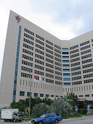
Tan Tock Seng Hospital is a tertiary referral hospital in Singapore, located in Novena. The hospital has 45 clinical and allied health departments, 16 specialist centres and is powered by more than 8,000 healthcare staff. Tan Tock Seng Hospital is Singapore's second-largest acute care general hospital with over 1,500 beds. TTSH has the busiest trauma centre in the country; 100 trauma cases are seen every day and 100 trauma surgeries are performed daily.

<span class="mw-page-title-main">Toa Payoh MRT station</span> Mass Rapid Transit station in Singapore

Toa Payoh MRT station is an underground Mass Rapid Transit (MRT) station on the North South line (NSL) in Toa Payoh, Singapore. Located in the town centre of Toa Payoh, it is integrated with the Toa Payoh Bus Interchange and the HDB Hub, headquarters of the Housing and Development Board. The station is underneath the intersection of three roads: Lorong 1 Toa Payoh, Lorong 2 Toa Payoh and Lorong 6 Toa Payoh.

<span class="mw-page-title-main">Novena MRT station</span> Mass Rapid Transit station in Singapore

Novena MRT station is an underground Mass Rapid Transit (MRT) station on the North South Line. Located along Thomson Road in Novena, Singapore, the station is located near landmarks such as Tan Tock Seng Hospital, Mount Elizabeth Novena Hospital and United Square. Planned as part of Phase One of the MRT system, under the working name Thomson, the station's name was changed to Novena in November 1982, after the Novena Church. Construction of the station commenced in January 1984, and the station opened in December 1987.

<span class="mw-page-title-main">Future developments in Singapore</span>

This article shows the notable future developments in Singapore. Most of them are currently under construction with most to be completed within the next five years.

<span class="mw-page-title-main">Balestier</span> Subzone of Novena Planning Area in Singapore

Balestier is a sub zone located in the planning area of Novena in the Central Region of Singapore. The main road, Balestier Road, links Thomson Road to Serangoon Road and the road continues on as Lavender Street. The area is home to rows of shophouses, such as the Sim Kwong Ho shophouses, the Balestier Art Deco shophouses, 412-418 Balestier Road, and 601-639 Balestier Road, low-rise apartments and commercial buildings as well as a shopping mall known as Shaw Plaza. Balestier also has another mall, Zhongshan Mall. There are several lighting and electrical shops along Balestier Road, which is also home to the Ceylon Sports Club and the Indian Association. The area is known for its food such as bak kut teh and chicken rice. In the area, there are several apartments, condominiums, and budget hotels.

<span class="mw-page-title-main">National Healthcare Group</span> Singapore group of healthcare institutions

The National Healthcare Group (NHG) is a group of healthcare institutions located in Singapore. The group was formed in 2000 and operates several hospitals, national specialty centers and polyclinics. Tan Tock Seng Hospital is the largest hospital in the group and serves as the flagship hospital for the cluster.

<span class="mw-page-title-main">National Centre for Infectious Diseases</span> Specialised hospital in Singapore

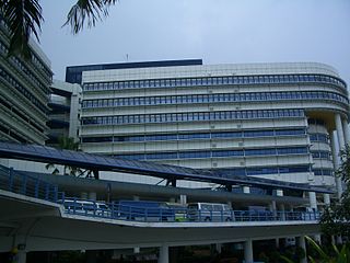
The National Centre for Infectious Diseases, previously known as the Communicable Disease Centre, is a national public health institute under the Ministry of Health of Singapore. Located next to Tan Tock Seng Hospital in Novena, all patients within the city-state who are affected with a highly contagious disease are also quarantined at the NCID and is used to control an outbreak of such diseases. The executive director of the hospital is Professor Yee-Sin Leo.

<span class="mw-page-title-main">Lavender, Singapore</span> Subzone of Kallang Planning Area in Central Region, Singapore

Lavender is a subzone within the planning area of Kallang, Singapore, as defined by the Urban Redevelopment Authority (URA). Lavender is composed of an area bounded by Tessensohn Road in the north; Balestier Road, Lavender Street and Crawford Street in the east; the Rochor River and Rochor Canal in the south; as well as Syed Alwi Road, Serangoon Road and Rangoon Road in the west.

Moulmein–Kallang Group Representation Constituency was a four-member Group Representation Constituency (GRC), comprising several city suburbs surrounding the Central Area of Singapore as well as a sizeable portion of the Central Business District. It existed from 2011 to 2015.

<span class="mw-page-title-main">Whampoa, Singapore</span> Housing zone in Balestier, Novena, Singapore

Whampoa is a housing estate located in the subzone of Balestier, which is a part of Novena planning area in Singapore, as defined by the Urban Redevelopment Authority. Within the context of the Housing and Development Board (HDB), however, Whampoa forms part of the Kallang/Whampoa New Town, together with the various housing precincts located in the adjacent Kallang planning area. This makes Kallang/Whampoa the only HDB new town that encompasses two planning areas, namely Novena and Kallang.

<span class="mw-page-title-main">Bendemeer, Singapore</span> Subzone of Kallang Planning Area in Central Region, Singapore

Bendemeer is a subzone within the planning area of Kallang, Singapore, as defined by the Urban Redevelopment Authority (URA). Its boundary is made up of the Pan Island Expressway (PIE) in the north; Serangoon Road, the Kallang River, Sungei Whampoa and Bendemeer Road in the east; Lavender Street and Balestier Road in the south; and the Central Expressway (CTE) in the west.

<span class="mw-page-title-main">Kampong Java</span> Subzone of Kallang Planning Area in Central Region, Singapore

Kampong Java is a subzone within the planning area of Kallang, Singapore, as defined by the Urban Redevelopment Authority (URA). It is bounded by the Central Expressway (CTE) in the west; Balestier Road in the north; Tessensohn Road, Race Course Road, Gloucester Road, Northumberland Road and Tekka Lane in the east; and Bukit Timah Road in the south.

<span class="mw-page-title-main">Health City Novena</span> Healthcare quarter in Singapore

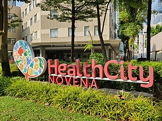
Health City Novena is an integrated healthcare hub located in Novena, Singapore. It anchors the country's Central Regional Health System. By co-locating healthcare services along the spectrum from acute care through rehabilitation to long term care, it aims to enhance collaboration among healthcare institutions.

References

  1. 1 2 "Singapore Infopedia – Development guide plan". National Library Board.
  2. 1 2 City Population – statistics, maps and charts | Novena
  3. 1 2 "Statistics Singapore - Geographic Distribution - 2018 Latest Data" . Retrieved 11 February 2019.
  4. Savage, Victor R. (2013). Singapore street names : a study of toponymics. Brenda S. A. Yeoh. Singapore. p. 636. ISBN   978-981-4484-74-9. OCLC   868957283.{{cite book}}: CS1 maint: location missing publisher (link)
  5. Singapore, National Library Board. "Joseph Balestier | Infopedia". eresources.nlb.gov.sg. Retrieved 19 February 2016.
  6. "Novena District Guide". Streetdirectory.com . Retrieved 20 July 2015.
  7. PropertyGuru (24 February 2017). "Eye on Novena: Bridging the past and future". Yahoo News.
  8. "500-bed rehab hub next to TTSH to open in five years | the Straits Times". The Straits Times. 22 March 2017.
  9. "HealthCity Novena". www.ttsh.com.sg. Retrieved 5 November 2023.
  10. "Speech by Health Minister Gan Kim Yong at the official launch of Health City Novena". www.moh.gov.sg. Ministry of Health.