Hancock County is a county located in the U.S. state of Maine. As of the 2020 census, the population was 55,478. Its county seat is Ellsworth. The county was incorporated on June 25, 1789, and named for John Hancock, the first governor of the Commonwealth of Massachusetts.

Brooksville is a town on Penobscot Bay in Hancock County, Maine, United States. As of the 2020 census, the town population was 935. It contains the villages of North Brooksville, South Brooksville, West Brooksville, Brooksville Corner, and Harborside.

Castine is a town in Hancock County in eastern Maine, United States. The population was 1,320 at the 2020 census. Castine is the home of Maine Maritime Academy, a four-year institution that graduates officers and engineers for the United States Merchant Marine and marine related industries.

The Penobscot Expedition was a 44-ship American naval armada during the Revolutionary War assembled by the Provincial Congress of the Province of Massachusetts Bay. The flotilla of 19 warships and 25 support vessels sailed from Boston on July 19, 1779, for the upper Penobscot Bay in the District of Maine carrying an expeditionary force of more than 1,000 American colonial marines and militiamen. Also included was a 100-man artillery detachment under the command of Lt. Colonel Paul Revere.

State Route 15 (SR 15) is a numbered state highway in Maine, United States. SR 15 runs over 180 miles (290 km) from Stonington in the south to Jackman in the north.

The Pentagoet Archeological District is a National Historic Landmark District located at the southern edge of the Bagaduce Peninsula in Castine, Maine. It is the site of Fort Pentagoet, a 17th-century fortified trading post established by fur traders of French Acadia. From 1635 to 1654 this site was a center of trade with the local Abenaki, and marked the effective western border of Acadia with New England. From 1654 to 1670 the site was under English control, after which it was returned to France by the Treaty of Breda. The fort was destroyed in 1674 by Dutch raiders. The site was designated a National Historic Landmark in 1993. It is now a public park.

Defence was an American Revolutionary War privateer that was part of the 1779 Penobscot Expedition, during the American Revolutionary War. A brigantine, she was built that year in Beverly, Massachusetts, and was scuttled near Stockton Springs, Maine in the later stages of the expedition. The wreck site was excavated in the 1970s, and was listed on the National Register of Historic Places in 1975.
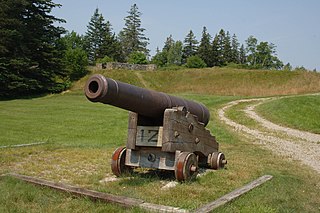
Fort George was a palisaded earthwork fort built in 1779 by Great Britain during the American Revolutionary War in Castine, Maine. Located at a high point on the Bagaduce Peninsula, the fort was built as part of an initiative by the British to establish a new colony called New Ireland.
The Tarr–Eaton House is an historic house at 906 Harpswell Neck Road in Harpswell, Maine. Built before 1783 and enlarged about 1840, it is a well-preserved 18th-century Cape with added Greek Revival features, and one of Harpswell's few surviving pre-Revolutionary War buildings. It was listed on the National Register of Historic Places in 2001.
Castine is a census-designated place (CDP) in the town of Castine in Hancock County, Maine, United States. The CDP population was 1,029 at the 2010 census, out of 1,366 people in the town as a whole.
New Ireland was a Crown colony of the Kingdom of Great Britain twice established in modern-day Maine after British forces captured the area during the American Revolutionary War and again during the War of 1812. The colony lasted four years during the Revolution, and eight months during the War of 1812. At the end of each war the British ceded the land to the United States under the terms of the Treaty of Paris and the Treaty of Ghent, respectively.

State Route 166 (SR 166) is part of Maine's system of numbered state highways, located in the southern coastal part of the state adjacent to the mouth of the Penobscot River. It runs just under fifteen miles (24 km) between the town of Castine and Orland at U.S. Route 1 (US 1) and SR 3/SR 15.

The Castine Historic District encompasses the entire southern tip of the peninsula on which the town of Castine, Maine is located. Covering about 1,800 acres (730 ha), this area was a center of colonial conflicts dating to the early 17th century, and was the site of military action during the American Revolutionary War and the War of 1812. Bypassed by the railroads, it has retained a village feel reminiscent of the early 19th century. It was listed on the National Register of Historic Places in 1973.

State Route 199 (SR 199) is part of Maine's system of numbered state highways, located in Hancock County. The route is almost completely within the town of Penobscot except for its southernmost 0.14 miles (0.23 km) near its terminus at SR 166A, which is in Castine. The route is 10.44 miles (16.80 km) long.

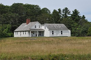
The John Perkins House is a historic house museum on the grounds of the Wilson Museum at 120 Perkins Street in Castine, Maine. Built in 1765 on Court Street, it is one of the oldest houses in Castine, and a well-preserved example of Georgian architecture; it was moved to its present location in 1968-69 and restored. The house was listed on the National Register of Historic Places in 1969. It is open for tours on a limited basis during July and August; the Gallery located in the basement is open from May to September.
The Von Mach Site is an archaeological site in Brooksville, Maine. Located on the south bank of the Bagaduce River opposite Castine, the principal feature of the site is a large shell midden, yielding evidence of a long period of human habitation. When excavated by pioneering Maine archaeologist Warren K. Moorehead in the 1920s, he described one of the ceramic finds at this site among the most finely decorated he had found anywhere on the New England coast. The site was listed on the National Register of Historic Places in 1989.

The Penobscot Expedition Site is a submerged historic archaeological area in the waters of the Penobscot River between Bangor and Brewer, Maine. The area is the site of the abandonment and loss of many vessels in the disastrous 1779 Penobscot Expedition, an American Revolutionary War expedition in which the rebellious Americans lost an entire fleet of ships. The site was listed on the National Register of Historic Places in 1973; it has been of interest to salvagers and later archaeologists since the early 19th century.

Chimney Farm is a historic farm property at 617 East Neck Road in Nobleboro, Maine. The heart of the farm is an early 19th-century farmhouse, which was from 1931 to their respective deaths home to the writers Henry Beston (1888–1968) and Elizabeth Coatsworth (1893–1986). Both were prominent regional award-winning writers, and the farm property played a prominent role on some of their writings. It was listed on the National Register of Historic Places in 2007.

State Route 175 (SR 175) is a state highway entirely in Hancock County, Maine that travels for 37.8 miles (60.8 km). The shape of the route is an unusual U-shape and travels along the peninsula surrounded by Blue Hill Bay, Eggemoggin Reach, and Bagaduce River. The route is signed as north-south but has two northern termini: at State Routes 15, 172, and 176 in Blue Hill, and at SR 166 in Penobscot. The transition point of the directional signage occurs about 2+1⁄2 miles (4.0 km) from the Blue Hill terminus.

Cape Rosier is a cape on the south central coast of the U.S. state of Maine, extending into the Atlantic Ocean. The peninsula reaches south and westward from the mainland into Penobscot Bay. It constitutes the western part of the town of Brooksville, in Hancock County, cut off from the rest of the town at a narrow neck where Orcutt Harbor extends from Eggemoggin Reach northward, and nearly reaches Smith Cove on the north side of the cape. To the west, it forms a part of the estuary of the Penobscot River. The head of the cape is at 44°18'43.2"N 68°49'36.6"W.

