Okolona, Arkansas

Last updated

Okolona, Arkansas
Okolona, AR 001.jpg
Arkansas Highway 182 in Okolona, January 2018
Clark County Arkansas Incorporated and Unincorporated areas Okolona Highlighted 0551530.svg
Location of Okolona in Clark County, Arkansas.
Coordinates: 34°0′2″N93°20′15″W / 34.00056°N 93.33750°W / 34.00056; -93.33750
Country United States
State Arkansas
County Clark
Area
[1]
  Total0.79 sq mi (2.05 km2)
  Land0.79 sq mi (2.05 km2)
  Water0.00 sq mi (0.00 km2)
Elevation
[2]
371 ft (113 m)
Population
 (2020)
  Total97
  Density122.32/sq mi (47.25/km2)
Time zone UTC-6 (Central (CST))
  Summer (DST) UTC-5 (CDT)
ZIP code
71962
Area code 870
FIPS code 05-51530
GNIS feature ID0052980 [2]

Okolona is a town near the western edge of Clark County, Arkansas, United States. The population was 147 at the 2010 census. [3]

Contents

The Battle of Elkin's Ferry of the Civil War was fought here during April 3–4, 1864, as a part of the Camden Expedition. Union forces, led by Maj. Gen. Fred Steele, sought to ford the Little Missouri River, as the local roads were impassable. The force reached Elkin's Ferry before the Confederate cavalry brigades, led by Brig. Gen. John S. Marmaduke, and the Confederates were defeated.

Okolona has several churches; the Saint Clair Baptist Church, Okolona Baptist Church, Okolona First United Methodist Church, and Center Grove United Methodist Church.

Geography

Okolona is located in western Clark County at 34°0′2″N93°20′15″W / 34.00056°N 93.33750°W / 34.00056; -93.33750 (34.000589, -93.337362). [4] Arkansas Highway 51 passes through the community, leading northeast 21 miles (34 km) to Arkadelphia, the county seat, and south 8 miles (13 km) to Interstate 30.

According to the United States Census Bureau, the town has a total area of 0.77 square miles (2.0 km2), all land. [3]

Demographics

Historical population
CensusPop.Note
1910 399
1920 49223.3%
1930 460−6.5%
1940 52514.1%
1950 458−12.8%
1960 344−24.9%
1970 233−32.3%
1980 200−14.2%
1990 113−43.5%
2000 16041.6%
2010 147−8.1%
2020 97−34.0%
U.S. Decennial Census [5]

As of the census [6] of 2000, there were 160 people, 70 households, and 45 families residing in the town. The population density was 79.2/km2 (204.8/mi2). There were 86 housing units at an average density of 42.6/km2 (110.1/mi2). The racial makeup of the town was 68.12% White and 31.88% Black or African American.

There were 70 households, out of which 22.9% had children under the age of 18 living with them, 57.1% were married couples living together, 5.7% had a female householder with no husband present, and 35.7% were non-families. 34.3% of all households were made up of individuals, and 12.9% had someone living alone who was 65 years of age or older. The average household size was 2.29 and the average family size was 2.96.

In the town, the population was spread out, with 20.0% under the age of 18, 9.4% from 18 to 24, 24.4% from 25 to 44, 24.4% from 45 to 64, and 21.9% who were 65 years of age or older. The median age was 42 years. For every 100 females, there were 100.0 males. For every 100 females age 18 and over, there were 91.0 males.

The median income for a household in the town was $30,833, and the median income for a family was $35,000. Males had a median income of $30,500 versus $17,500 for females. The per capita income for the town was $14,318. None of the families and 0.6% of the population were living below the poverty line.

An old school building in Okolona, January 2018 Okolona, AR 003.jpg
An old school building in Okolona, January 2018

Education

Public education for elementary and secondary school students is provided by the Gurdon School District with area students graduating from Gurdon High School. [7]

It was served by the Okolona School District until that district was dissolved on July 1, 1987. The Gurdon district was one of several absorbing territory from the former Okolona district. [8]

See also

Related Research Articles

<span class="mw-page-title-main">Almyra, Arkansas</span> Town in Arkansas, United States

Almyra is a town in Arkansas County, Arkansas, United States. The population was 283 at the 2010 census.

<span class="mw-page-title-main">Big Flat, Arkansas</span> Town in Arkansas, United States

Big Flat is a town in Baxter and Searcy counties in the U.S. state of Arkansas. The population was 88 at the 2020 census.
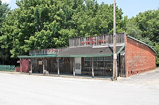
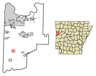
<span class="mw-page-title-main">Caddo Valley, Arkansas</span> Town in Arkansas, United States

Caddo Valley is a town in Clark County, Arkansas, United States. The population was 635 at the 2010 census.

<span class="mw-page-title-main">Gum Springs, Arkansas</span> Town in Arkansas, United States

Gum Springs is a town in Clark County, Arkansas, United States. The population was 120 at the 2010 census, down from 194 in 2000.

<span class="mw-page-title-main">Whelen Springs, Arkansas</span> Town in Arkansas, United States

Whelen Springs is a town in Clark County, Arkansas, United States. The population was 92 at the 2010 census. From 1930 through 1939 the town thrived, being a main hub of operations for the then powerful Ozan Lumber Company.

<span class="mw-page-title-main">Tull, Arkansas</span> Town in Arkansas, United States

Tull is a town in Grant County, Arkansas, United States. The population was 448 at the 2010 census, up from 358 in 2000. It is part of the Central Arkansas region.

<span class="mw-page-title-main">Oil Trough, Arkansas</span> Town in Arkansas, United States

Oil Trough is a town in Independence County, Arkansas, United States. The population was 260 at the 2010 census. The town is believed to have acquired its name in the early 19th century from a trough used to render bear fat, which was sold to customers in New Orleans.

<span class="mw-page-title-main">LaGrange, Arkansas</span> Town in Arkansas, United States

LaGrange is a town in Lee County, Arkansas, United States. The population was 89 at the 2010 census, down from 122 at the 2000 census.

<span class="mw-page-title-main">Black Springs, Arkansas</span> Town in Arkansas, United States

Black Springs is a town in Montgomery County, Arkansas, United States. The population was 96 at the 2020 census.

<span class="mw-page-title-main">Oden, Arkansas</span> Town in Arkansas, United States

Oden is a town in Montgomery County, Arkansas, United States. As of the 2020 census, its population was 180, down from 232 in 2010.

<span class="mw-page-title-main">Cale, Arkansas</span> Town in Arkansas, United States

Cale is a town in Nevada County, Arkansas, United States. The population was 75 at the 2000 census. It is part of the Hope Micropolitan Statistical Area.

<span class="mw-page-title-main">Rosston, Arkansas</span> Town in Arkansas, United States

Rosston is a town in south-central Nevada County, Arkansas, United States. The population was 265 at the 2000 census. It is part of the Hope Micropolitan Statistical Area.

<span class="mw-page-title-main">Casa, Arkansas</span> Town in Arkansas, United States

Casa is a town in Perry County, Arkansas, United States. Located in Central Arkansas, the town initially grew due to the mining of coal, harvesting of timber and cultivation of cotton. The Great Depression reduced the population greatly, and the community's economy never recovered. The population was 171 at the 2010 census.

<span class="mw-page-title-main">Daisy, Arkansas</span> Town in Arkansas, United States

Daisy is a town in Pike County, Arkansas, United States. Its population is 88 as of the 2020 census. Daisy is also the home of Daisy State Park.

<span class="mw-page-title-main">Wickes, Arkansas</span> City in Arkansas, United States

Wickes is a city in Polk County, Arkansas, United States. The population was 754 at the 2010 census.

<span class="mw-page-title-main">Ulm, Arkansas</span> Town in Arkansas, United States

Ulm is a town in Prairie County, Arkansas, United States. The population was 205 at the 2000 census.

<span class="mw-page-title-main">O'Kean, Arkansas</span> Town in Arkansas, United States

O'Kean is a town in Randolph County, Arkansas, United States. The population was 192 at the 2020 census.

<span class="mw-page-title-main">Griffithville, Arkansas</span> Town in Arkansas, United States

Griffithville is a town in White County, Arkansas, United States. Windle Porter is the current mayor. The population was 262 at the 2000 census.

<span class="mw-page-title-main">Corinth, Arkansas</span> Town in Arkansas, United States

Corinth is a town in Yell County, Arkansas, United States. The population was 65 at the 2000 census. It is part of the Russellville Micropolitan Statistical Area.

Okolona is a former census-designated place (CDP) in southern Louisville/Jefferson County, Kentucky, United States. It is centered on the intersection of Preston Highway and the Outer Loop. The population was 17,807 at the 2000 census. When the government of Jefferson County merged with the city of Louisville, Kentucky in 2003, residents of Okolona also became citizens of Louisville Metro. As a result, Okolona is said to be a neighborhood within the city limits of Louisville.

References

  1. "2020 U.S. Gazetteer Files". United States Census Bureau. Retrieved October 29, 2021.
  2. 1 2 U.S. Geological Survey Geographic Names Information System: Okolona, Arkansas
  3. 1 2 "Geographic Identifiers: 2010 Demographic Profile Data (G001): Okolona town, Arkansas". U.S. Census Bureau, American Factfinder. Archived from the original on February 12, 2020. Retrieved June 16, 2014.
  4. "US Gazetteer files: 2010, 2000, and 1990". United States Census Bureau. February 12, 2011. Retrieved April 23, 2011.
  5. "Census of Population and Housing". Census.gov. Retrieved June 4, 2015.
  6. "U.S. Census website". United States Census Bureau . Retrieved January 31, 2008.
  7. "SCHOOL DISTRICT REFERENCE MAP (2010 CENSUS): Clark County, AR." U.S. Census Bureau. Retrieved on May 26, 2018.
  8. "ConsolidationAnnex_from_1983.xls Archived 2015-09-12 at the Wayback Machine ." Arkansas Department of Education. Retrieved on October 13, 2017.

Commons-logo.svg Media related to Okolona, Arkansas at Wikimedia Commons