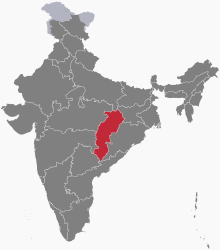
Chhattisgarh is a landlocked state in Central India. It is the ninth largest state by area, and with a population of roughly 30 million, the seventeenth most populous. It borders seven states – Uttar Pradesh to the north, Madhya Pradesh to the northwest, Maharashtra to the southwest, Jharkhand to the northeast, Odisha to the east, Andhra Pradesh and Telangana to the south. Formerly a part of Madhya Pradesh, it was granted statehood on 1 November 2000 with Raipur as the designated state capital.
Raipur district is a district in the Chhattisgarh state of India. Its administrative headquarters is the city of Raipur. The district is rich in mineral resources and there are many wildlife sanctuaries. With a population of 2 million, it is the most populous district of Chhattisgarh.

Dantewada District, also known as Dantewara District or Dakshin Bastar District, is a district in the Indian state of Chhattisgarh. Dantewada is the district headquarters. The district is part of Bastar Division. Until 1998, Dantewada District was a tehsil of the larger Bastar District.

Rajnandgaon is a district of the state of Chhattisgarh in central India. The administrative headquarters the district is Rajnandgaon town.

Jagdalpur is a city located in the southern part of Chhattisgarh state in India. It is the administrative headquarters of the Bastar district and Bastar division. Before the independence of India, it also served as the capital of the erstwhile princely state of Bastar. It is the fourth largest city of Chhattisgarh. A city known For its Distinct art and culture, the Tourism capital of Chhattisgarh and one of the Fastest Growing City of State.It is also known as ' Mumbai Of Chhattisgarh ' for its diverse demographics and second biggest financial hub in the state after Raipur.

The Eastern Highlands moist deciduous forests, presently known as East Deccan moist deciduous forests, is a tropical and subtropical moist broadleaf forests ecoregion in east-central India. The ecoregion covers an area of 341,100 square kilometers (131,700 sq mi), extending across portions of Andhra Pradesh, Chhattisgarh, Jharkhand, Madhya Pradesh, Maharashtra, Odisha, and Telangana states.
Sanjay National Park is a national park in Manendragarh-Chirmiri-Bharatpur district of Chhattisgarh and Singrauli district of Madhya Pradesh, India. It covers an area of 2,300 km2 (890 sq mi) and is a part of the Sanjay-Dubri Tiger Reserve. It is located in the Narmada Valley dry deciduous forests ecoregion.

The Narmada Valley dry deciduous forests are a tropical dry forest ecoregion of central India. The ecoregion lies mostly in Madhya Pradesh state, but extends into portions of Chhattisgarh, Maharashtra, Karnataka and Uttar Pradesh states.

The following outline is provided as an overview of, and topical guide to, India:
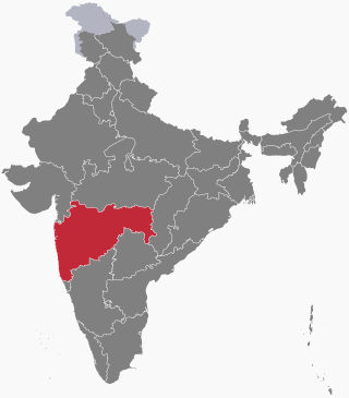
The following outline is provided as an overview of and topical guide to Maharashtra:
The following outline is provided as an overview of and topical guide to Tamil Nadu:
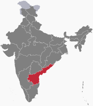
The following outline is provided as an overview of and topical guide to Andhra Pradesh:
Veer Narayan Singh (1795–1857) was a landlord from Sonakhan, in the present-day Indian State of Chhattisgarh. He spearheaded the 1857 rebellion in Chhattisgarh.

The following outline is provided as an overview of and topical guide to Telangana:

Tourism is an important part of the economy of the Indian state of Chhattisgarh, India's tenth largest state. The state has many ancient monuments, rare wildlife, carved temples, Buddhist sites, palaces, water falls, caves, rock paintings and hill plateaus.

The following outline is provided as an overview of and topical guide to Arunachal Pradesh:
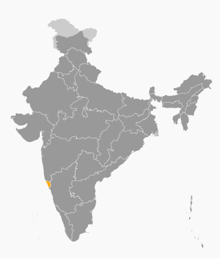
The following outline is provided as an overview of and topical guide to Goa:

The following outline is provided as an overview of and topical guide to Jharkhand:
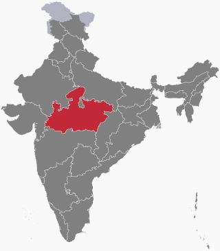
The following outline is provided as an overview of and topical guide to Madhya Pradesh: